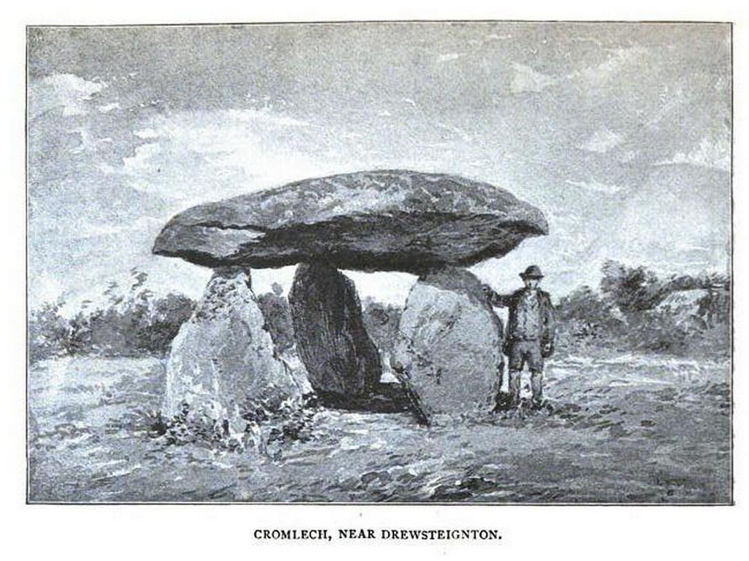
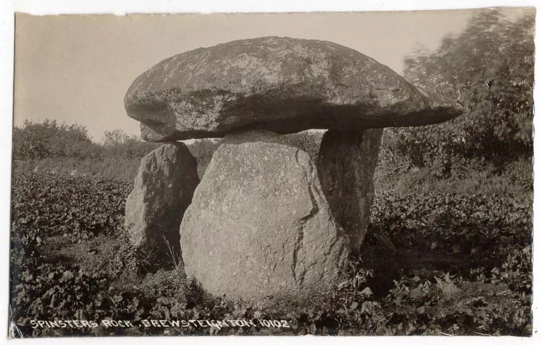
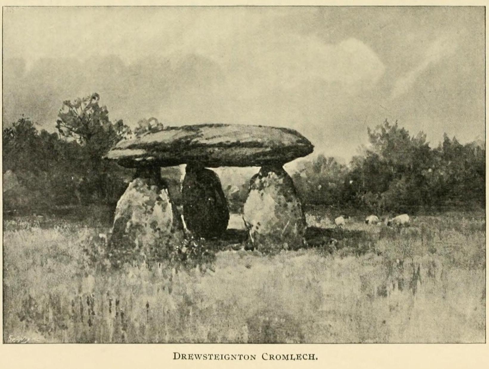
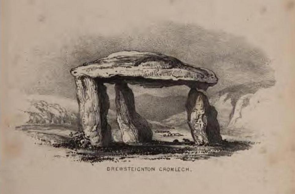
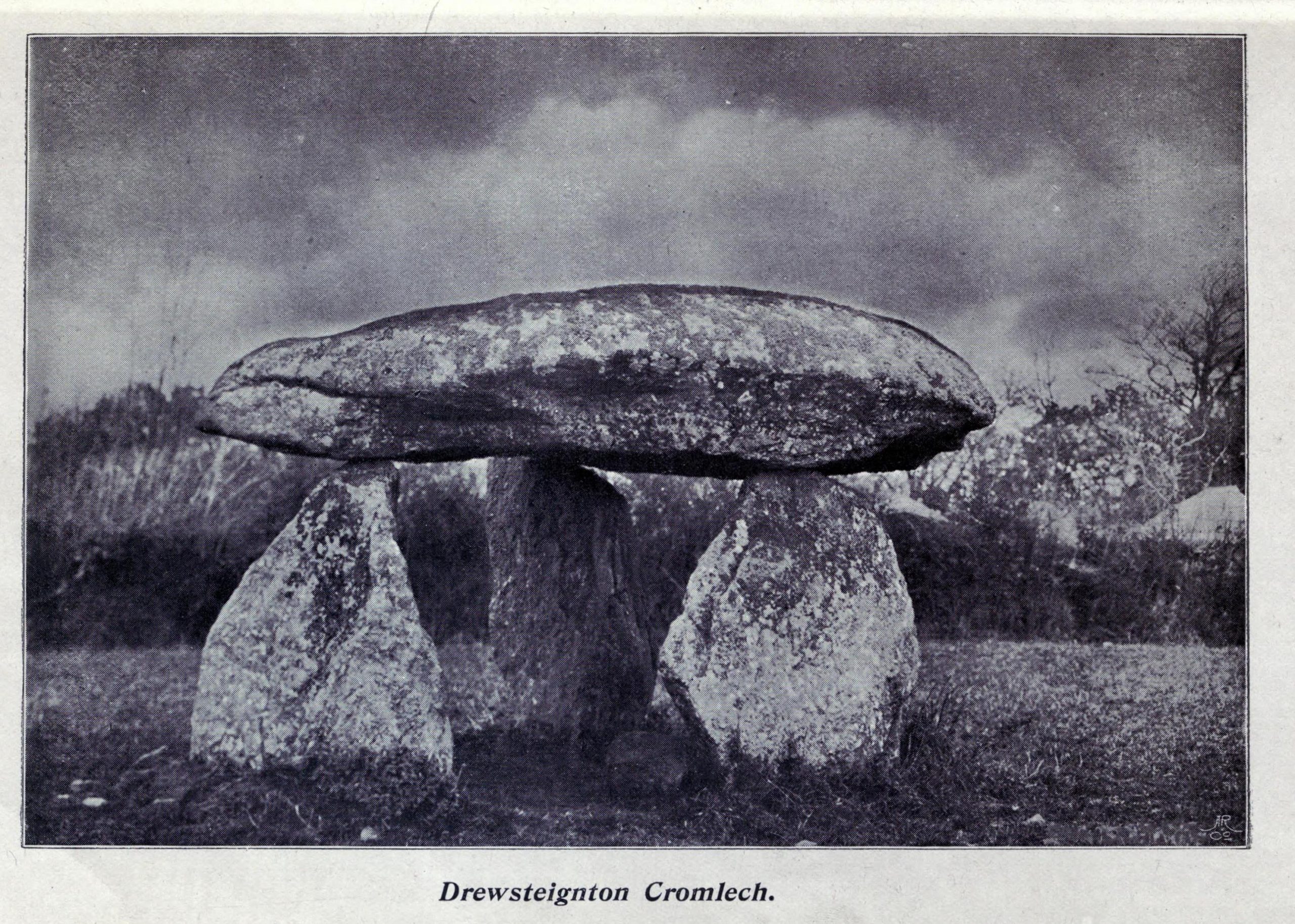
Highlighted on Benjamin Donn’s map of Devon in 1765, this impressive neolithic dolmen consists of three large granite support stones between 5 ft 7 in and 7 ft 7 in tall, surmounted by a large capstone measuring 15 feet by 10 feet. It collapsed in 1862 but was restored later the same year.
Folklore
In Murray’s (1851) Handbook for Travellers he told the following tale of the site:
This interesting old monument derives its name from a whimsical tradition that three spinsters (who were spinners) erected it one morning before breakfast; but “may we not,”* says Mr. Rowe (Peramb. of Dartmoor), “detect in this legend of the three fabulous spinners the terrible Valkyriur of the dark mythology of our Northern ancesters – the Fatal Sisters, the choosers of the slain, whose dread office was to ‘weave the warp and weave the woof of destiny.'”
Polwhele informs us that the legend varies, in that for the three spinsters some have substituted three young men and their father, who brought the stones from the highest part of Dartmoor; and in this phase of the legend has been traced an obscured tradition of Noah and his three sons.
.. The hill on which it stands commands an excellent view of Cawsand Beacon. About 100 yds. beyond the cromlech on the other (N.) side of the lane, is a pond of water, of about 3 acres, called Bradmere Pool, prettily situated in a wood. It is said to be unfathomable, and to remain full to the brim during the driest seasons, and some regard it as artificially formed and of high antiquity – in short a Druidical pool of lustration connected with the adjacent cromlech..
.. The country-people have a legend of a passage formed of large stones leading underground from Bradmere to the Teign, near the logan stone..
References:
Baring-Gould, Sabine, A Book of Dartmoor, London 1900.
Crossing, William, Gems in a Granite Setting, Western Morning News: Plymouth 1905.
Falcon, T.A., Dartmoor Illustrated, James G. Comin: Exeter 1900.
Murray, John, A Hand-book for Travellers in Devon & Cornwall, John Murray: London 1851.
Ormerod, G. Waring, Notes on Rude Stone Remains Situate on the Easterly Side of Dartmoor, privately printed 1873.
Page, John Lloyd Warden, An Exploration of Dartmoor and its Antiquities, Seeley: London 1892.
Worth, R. Hansford, Worth’s Dartmoor, David & Charles: Newton Abbot 1967.
Acknowledgements:Huge thanks for use of the Ordnance Survey map in this site profile, reproduced with the kind permission of the National Library of Scotland.
In an Address to the Scottish Society of Antiquaries in the middle of the 19th century, Sir James Simpson (1862) pointed out the outright destruction and vandalism that incoming land-owners (english mainly, and probably christians too) had inflicted on the monuments of the Scottish people. Stone circles and two cromlechs, he said, that had existed in this part of West Lothian for thousands of years, were recently destroyed when Simpson was alive. One of them was here at Kipps. He told:
“In 1813 the cromlech at Kipps was seen by Sir John Dalzell, still standing upright. In describing it, in the beginning of the last century, Sir Bobert Sibbald states that near this Kipps cromlech was a circle of stones, with a large stone or two in the middle; and he adds, “many such may be seen all over the country.” They have all disappeared; and latterly the stones of the Kipps circle have been themselves removed and broken up, to build, apparently, some neighbouring field-walls, though there was abundance of stones in the vicinity equally well suited for the purpose.”
Simpson suggested, quite rightly, that efforts should be made to resurrect the old monument. In his day the fallen remnants of the ‘cromlech’ that had stood inside the circle were still in evidence and it was highlighted on the early OS-map of the region; and when the northern antiquarian Ratcliffe Barnett (1925) came walking here earlier in the 20th century he told he could still see “the remains of an ancient cromlech, which stood within a circle of stones.” Around the same time, the Royal Commission (1929) lads looked for these remains but seemed to have gone to the wrong site, “a quarter-mile northwest of Kipps Farm”, where they nevertheless found,
“a tumbled mass of boulders containing about thirty stones, one being erect; they vary from 6 by 3 by 1½ feet by 4 by 3 by 2½ feet, and are probably the remains of a cairn.”
When the renowned chambered tomb explorer Audrey Henshall (1972) followed up the directions of the Royal Commission, she was sceptical of giving any prehistoric provenance to the rocks there, describing them simply as geological “erratics.”
The very place-names Kipps may derive from the monument, for as Angus MacDonald (1941) told, “the word seems to come from Gaelic caep, ‘a block’”, but the word can also mean “a sharp-pointing hill, a jutting point, or crag on a hill”, and as the house and castle at Kipps is on an outlying spur, this could be its meaning.
Folklore
Local lore told how lads and lassies would use the stones as a site to promise matrimony with each other, by clasping their hands through a gap on the top boulder. Using holes in or between stones to make matrimonial bonds, where the stone is the witness to the ceremony, occurs at many other sites and became outlawed by the incoming christian cult, which took people away from the spirits of rock, waters and land.
References:
Barnett T. Ratcliffe, Border By-Ways & Lothian Lore, John Grant: Edinburgh 1925.
Duns, J., “Notes on a Burial Mound at Torphichen, and an Urn found near the ‘Cromlech’ at Kipps, Linlithgowshire”, in Proceedings of the Society of Antiquaries, Scotland, volume 12, 1878.
Henshall, Audrey S., The Chambered Tombs of Scotland – volume 2, Edinburgh University Press 1972.
This fascinating looking carving (in my personal Top 10 of all-time favourites cup-and-rings in the UK!) was unfortunately destroyed sometime between 1918 and 1920. A huge pity, as the design on the rock is almost unique in its ‘linear’ system of cups running a considerable length across the surface of the stone (like the similar design found at Old Bewick in Northumberland).
Wilson’s 1851 drawing of the Witches’ Stone
Simpson’s 1866 drawing of the Witches Stone
Shown first of all on Kirkwood’s Environs of Edinburgh map in 1817 (above), this legendary rock was found amidst a cluster of other cup-and-ring stones at Tormain (some are still there) and was initially said by Daniel Wilson (1851) to have been the giant capstone of a cromlech that once stood here, but whose structure had fallen away. This idea is implied in the earliest drawing we have of the stone in Wilson’s magnum opus (above); Sir J.Y. Simpson (1867) gave us a similar impression with his drawing a few years later. But upon visiting the Witches Stone just as his book was going to the press, Mr Wilson visited the site and proclaimed that he “altogether doubted if they are the remains of a cromlech”, and what rested here were more probably just fascinating geological remains, with even more fascinating carvings on top!
In the years that followed Wilson’s initial description, the Witches Stone was visited and described by a number of eager antiquarians. Simpson (1867) gave us a quite revealing account, telling:
“On the farm of Bonnington, about a mile beyond the village of Ratho…are the remains of ‘this partially ruined cromlech’…with the capstones partially displaced, as if it had slid backwards upon the oblique plane of the huge stones or stone which still supports it. Two or three large blocks lie in front of the present props. Its site occupies a most commanding view of the valley of the Almond, and of the country and hills beyond. The large capstone is a block of secondary basalt or whinstone, about twelve feet long, ten in breadth and two in thickness. Its upper surface has sculptured along its median line a long row of some twenty-two cup-cuttings; and two more cup-cuttings are placed laterally: one, half a foot to the left of the central row and at its base; the other, two feet to the right of the tenth central cup and near the edge of the block. The largest of the cups are about three inches in diameter and half an inch in depth; but most of them are smaller and shallower than this…”
A few years later another early petroglyph authority, J. Romilly Allen (1882), visited the Witches Stone and found “an Ordnance bench mark (had been) cut on the stone itself”! He then continued with his own description of this once-important megalithic site:
“The Witch’s Stone is a natural boulder of whinstone, rounded and smoothed by glacial action, whoso upper surface slopes at an angle of about 35° with the horizon. The length of the sloping face is 8 feet and at the top is a flat place 2 feet wide. The breadth of the stone is 11 feet 3 inches at the upper end, and 4 feet at the lower end. The thickness varies from 2 to 3 feet. The highest part of the stone is 6 feet 6 inches above the ground, and the lowest 1 foot 6 inches. It rests on what has originally been a portion of the same boulder, but is now a mass of whinstone broken up into several fragments, which serve as supports to prop up the stone above. Viewed from the north side the whole presents the appearance of a cromlech, the upper stone forming the cap, and the disintegrated portion below the supports. This notion, however, will be clearly seen to be erroneous on looking at it from the opposite side, as shown on the accompanying sketch…where the crack separating the two portions of the boulder is very apparent… The sculpturings consist of twenty-four cups varying in diameter from 1½ to 3 inches. Twenty-two of these cups are arranged in an approximately straight line along the sloping face of the stone, and divide it into two almost equal parts. The two remaining cups lie, one 7½ inches to the left of the lowest cup of the central row, and the other 2 feet 3 inches to the right of the ninth cup up the stone… The field in which the Witch’s Stone is situated is called “Knock-about.” The sloping face of the stone has been much polished by the practice of people climbing on to the top and sliding down. Some of the cups are almost obliterated in consequence. The stone forms a very prominent feature in the view, and must always have attracted attention from its peculiar shape.”
Some twenty years after Allen, the megalithomaniac Fred Coles (1903) came and checked the Witches Stone out for himself and, as happens, had a few additional things to say about the place:
“Although this huge boulder and its cup-marks have been more than once figured and described, I found, on a close examination of the broad surface of the Stone, that none of the illustrations showed the cup-marks in their exact relation to each other, nor in their true relation to the contour of the Stone. The drawing shown above…was made after a careful measurement by triangulation of the Stone; and it is claimed to be the first that shows that the cups, two and twenty in number, are not disposed in one continuous line, but that thirteen follow each other from the high south edge of the stone for a distance of exactly 6 feet, and nine others lie a few inches to the west, occupying a space 3 feet long of the overcurving edge of the north end. It is further shown that, at a point 2 feet 3 inches west of the ninth cup-mark, there is another one quite as large as the largest in the rows near the middle of the Stone. The south edge (A B) has slipped a little down from its original height, the boulder being frost-split horizontally; its height there above ground is 8 feet. The northern and narrower end is about 2 feet above ground, and does not touch the ground, as it rests upon its lower portion, beyond which it projects a few inches. The cup-marks run due north.”
Fred Coles 1903 drawing
If the Witches Stone was in fact a natural outcrop stone and not a cromlech, this very last point telling that “the cup-marks run due north” probably had much greater importance than a mere compass-bearing to the people who etched this carving. For in pre-christian religious structures across the northern hemisphere, north is commonly representative of death and the land of the gods. In magickal rites “it is the place of greatest symbolic darkness,” as neither sun nor moon ever rise or set there. Additionally, north is the place where, in shamanic traditions, the heavens are tied to the Earth: the cosmic axis itself that links heaven, Earth and underworld. In early neolithic traditions this mythic structure was probably endemic. Whether its magickal relevance was intended here, at this stone, we will probably never know…
Folklore
Folklore tells that the Witches Stone was one of the sites used in magickal rites by the Scottish occultist, Michael Scot. J.R. Allen’s (1882) description of “the sloping face of the stone has been much polished by the practice of people climbing on to the top and sliding down,” may relate to folk memory of fertility rites once practiced here, as found at similarly carved rocks in the UK and across the world.
McLean, Adam, The Standing Stones of the Lothians, Megalithic Research Publications: Edinburgh no date (c.1978).
Morris, Ronald W.B., The Prehistoric Rock Art of Southern Scotland, BAR: Oxford 1981.
Royal Commission on the Ancient & Historical Monuments of Scotland, Inventory of Monuments and Constructions in the Counties of Midlothian and West Lothian, HMSO: Edinburgh 1929.
Simpson, James, Archaic Sculpturings of Cups, Circles, etc., Upon Stones and Rocks in Scotland, England and other Countries, Edmonston & Douglas: Edinburgh 1867.
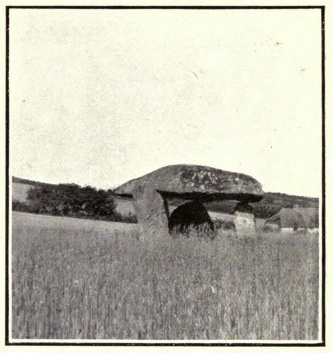
From Tregele village, take the minor southeast road towards Llanfechell, until you pass the second dirt-track on your right (both tracks take you to a local farm). The second track takes you to the aptly-named farmhouse of ‘Cromlech’ – which is where you need to ask the farmer (a friendly chap) if you can have a gander at his rocks! To which he should say, “Aye…it’s over there in the field.” You can’t really miss ’em!
Archaeology & History
This was once an impressive prehistoric tomb by the size of things, but has been knocked about a bit over the centuries. Even when Glyn Daniel (1950) described it, he said that “at present this site consists of nothing more than a number of large stones lying in a field — some flat and others slightly tilted.” And it hasn’t changed much since then! One of the earliest descriptions of Foel Fawr was by John Skinner (1908) in his fine tour around Anglesey in the early 19th century, where he told:
Skinner’s 1804 drawing
Foel Fawr tomb
“From hence passing by an old mansion named Cromlech now tenanted by a farmer we came to the spot where many large stones were lying scattered promiscuously on the ground and one nearly square measuring nine feet across leaning against some uprights about six feet high. From the appearance of this place I should rather imagine that it had been the interior or cistfaen of a carnedd and this opinion seems somewhat confirmed by the accounts of the common people who remember great quantities of stone having been removed to form a wall.”
References:
Daniel, Glyn E., The Prehistoric Chamber Tombs of England and Wales, Cambridge University Press 1950.
Skinner, John, Ten Days’ Tour through the Isle of Anglesey, December 1802, Charles J. Clark: London 1908.

")
")
sm")
")

