Blakey Topping, Allerston, North Yorkshire

Sacred Hill:  OS Grid Reference – SE 8731 9377
Getting Here

Blakey Topping (James Elkington)

From Pickering, take the A169 towards Whitby. When you get to the Car Park at the ‘Hole-of-Horcum’ – (you can’t miss it), park the car and walk North along the side of the road towards Whitby. After 60 yds, take the track East. Follow this for approximately a mile until the track splits. Take the concrete track left towards the farmhouse of ‘Newgate Foot’. Go through the yard past the house on the right, and you will come to a stream and a gate and there, ahead of you, rises Blakey Topping…

Archaeology & History

The giant hill of Blakey Topping was recorded as early as 1233 CE and in a simplistic style just means the ‘black mound’; but this derivation has additional ingredients, implying it as a ‘black meeting-place’ or moot.  Black in the etymological sense also implies ‘shining’ and it may also relate to the northern airt of black (meaning death, darkness, north, etc), when you’re stood at the ruined stone circle 400 yards to the south. But I’m speculating here…

Several 19th century antiquarians suggested there may have once been a cairn on top of the hill, but others who’ve explored this idea seem to have put it to bed.

Folklore

This great hill is well recognised amongst local people and, to this day, its animistic creation myths and other folklore elements are still spoken.  When the photographer James Elkington recently visited the nearby standing stones, he bumped into the old farmer who told him how his father had seen the faerie-folk on the hill many years back.  And its modern reputation as a gorgeous site adds to such lore, which dates way back.

In Frank & Harriett Elgee’s (1933) archaeology work, they narrated the old creation myth that local people used to tell of this great hill,

“A witch story related by a native 25 years ago attempts to explain two conspicuous natural features two miles apart on Pickering Moor; Blakey Topping, an isolated hill, and the Hole of Horcum, a deep basin-shaped valley. The local witch had sold her soul to the devil on the usual terms, but when he claimed it, she refused to give it up, and flew over the moors, with the devil in hot pursuit. Overtake her he could not, so he grabbed up a handful of earth and flung it at her. he missed his aim and she escaped.  The Hole of Horcum remains to prove where he tore up the earth and Blakey Topping where it fell to the ground.

“From our point of view the significance of this story lies in the fact that between the Hole and the Topping there is a Bronze Age settlement site at Blakey Farm, with its stone circle. The rough trackway leading from the Hole to the circle is known as the Old Wife’s Way, presumably also marking the witch’s flight. This, together with other Old Wife’s Ways, preserves as it were Bronze Age church tracks”.
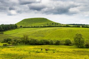
Looking up from the SW (James Elkington)

A relative variation on this tells that the Hole of Horcum was made by the local giant, Wade. He was having a row with his wife, Bell, and got so angry that he scooped out a lump of earth and threw it at her.  The huge geological feature known as the Hole of Horcum is the dip left where he scooped out the earth, and Blakey topping, the clod itself, resting in situ where it landed.  A christian appropriation of the story replaces Wade and his wife with their ‘devil’: a puerile element unworthy of serious consideration.

In more recent times, the old geomancer Guy Ragland Phillips (1976; 1985) found that a number of alignments, or leys (known as a ‘node’), centred on Blakey Topping: twelve in all, reaching out and crossing numerous holy wells, prehistoric tumuli, standing stones, etc.  The precision of the alignments is questionable, yet the matter of the hill being a centre-point, or omphalos, would seem moreso than not.

References:

  1. Elgee, F. & H.W., The Archaeology of Yorkshire, Methuen: London 1933.
  2. Phillips, Guy Ragland, Brigantia, RKP: London 1976.
  3. Phillips, Guy Ragland, The Unpolluted God, Northern Lights: Pocklington 1987.
  4. Smith, A.H., The Place-Names of the North Riding of Yorkshire, Cambridge University Press 1928.

Links:

  1. Mountains, Myths and Moorlands

Acknowledgements:  Big thanks to the photographer, James Elkington, for use of his photos in this profile. Cheers mate.

© Paul Bennett & James ElkingtonThe Northern Antiquarian


Beinn na Caillich cairn, Broadford, Skye

Chambered Cairn:  OS Grid Reference – NG 6291 2377

Getting Here

Henshall’s plan of Beinn na Caillich tomb

From Broadford town, head northwest outta town up the A87 for a mile, turning left and stopping by the electricity station just 100 yards along.  Follow the line of cables down, SE, through the trees, dead straight for about 600 yards (crossing the large stream about halfway) till you notice an open gap through the trees on your right where, 40 yards in, there’s a large circular arena which has been kept aside amidst which a scattered mound is clearly visible.  In this opening in the trees…this is where the tomb/s rest…

Archaeology & History

Sited a mile east on lowlands beneath the shadow of Beinn na Cailleach mountain, with its host of heathen legends and lore, is reputed to be the prehistoric remains of an important ancestral burial site, under dominion of the cailleach’s eye.  In Audrey Henshall’s (1972-2) magnum opus she describes the remains of what may be two separate tombs here as “difficult to interpret”; even “questioning whether they do in fact represent the ruins of a chambered cairn” as has been ascribed.  The site is still included in the Canmore survey, where they cite the same reference as I do here, but add no additional data to Henshall’s query.  There is obviously something to be seen here, but until excavation of the site has been done, the exact nature of what lies here cannot be clarified.  Miss Henshall wrote:

“There is a setting of stones forming about a third of the west side of a circle which would have a diameter of about 30ft if complete; its greatest N to S measurement is 23ft. The stones are thin slabs 4 to 5in thick, up to 3ft 6in long, set on their long sides and projecting up to 2ft above the turf.  The stones have probably been reduced in size due to natural fracturing as the stone readily flakes away. Within this setting, which might be interpreted as the kerb of a cairn, there is a rise of about 1ft above ground level and the grass grows greener, but except for this and a number of boulders lying about the site, there is no sign of cairn material. This is curious as there is no obvious reason for removing it.

“Inside the ‘kerb’ there is a horse-shoe setting of five similar slabs, just visible except for two on the S side which project 1ft 2in due to some peat on their N side having been removed. The enclosed area is 7ft wide by 7ft 6in long, open on the E end.  On this side, 14ft from the W end of the setting, is a larger stone, set on end, 2ft 8in high.  This might be regarded as a portal stone except that it is set opposite the centre of the open end of the horse-shoe setting, and there is a low thin slab projecting westwards from the middle of its W face.  E of this there lie a number of flat slabs and boulders, the larger (some measuring 3ft 8in by 3ft and 4 by 2ft) marked on the plan, but they do not suggest the form of the original structure.

“A stone is set radially to the kerb, 15ft 8in to the N.  It is on its long edge, 4ft 11in long and 2ft 2in high.  Twenty eight feet S of the kerb there is a circular setting of small boulders, 6ft 6in across inside, and part of another concentric setting can be traced 6ft outside these.”

References:

  1. Henshall, Audrey, The Chambered Tombs of Scotland – volume 2, Edinburgh University Press 1972.

© Paul BennettThe Northern Antiquarian


Beinn na Cailleach, Kylerhea, Skye

Sacred Mountain:  OS Grid Reference – NG 770 229

Also Known as:

  1. Beinn na Caillich

Getting Here

As you drive down the A87 road towards Broadford from the Kyle, just before Breakish there’s a small road on the left that runs down to Glen Arroch, where the forest lines the hill.  A couple of miles beyond the end of the forest, watch out for the TV mast on the slopes on the right-hand side of the road.  Stop here and go up the slopes on the left-side of the road (north), to the peak of Sgurr na Coinnich; and once here you’ll see the high rocky peak of Beinn na Cailleach a half-mile to your northeast.  

Folklore

The legend of this sacred mountain was described at some length in Otta Swire’s (1961) excellent work on the Isle of Syke.  She wrote:

“”As you drive down the road towards Broadford, three peaks can be seen to the north; the first two are Beinn na Greine (2,000 feet) and Scurr na Coinnich (2,401 feet); the third and most northerly is Beinn na Caillich (2, 396 feet). This last must not be confused with the Beinn na Caillich near Broadford, which is one of the Red Cuchullins although, just to make it more confusing, on the summit of our Beinn na Caillich, as on that of her larger sister, tradition has placed a woman’s grave. This time it is that of a giantess, one of the Fiennes: beneath her body is a large crock filled with gold and jewels, for she was a great lady, no less than Grainnhe herself, wife of Fionn, and at her burial every man of the Fiennes, for love of her and of their leader, cast their rarest jewels into the earthenware crock to do her honour. Her story, as is so usual in Celtic legend, is a sad one. Grainne is the daughter of the King of Morven and is reputed the fairest and truest princess in all Alban, so the Grey Magician, who hates all that is good, carries her off. One day, as Fionn and his men rest after hunting, an old, old woman, wrapped in the red mantle that denoted royal blood, comes to him, tells him of the theft of Grainnhe and begs him to rescue her. He agrees, whereupon she gives him a fir twig and three small pebbles, all highly magic; she then goes out of sight ‘on an eddy of the western wind, growing smaller as she went until she seemed no bigger than a butterfly, a honey bee, a red spider on a thin rope of its web, and a speck of dust in the sun’. Fionn sets out and after many adventures, during which he is assisted by several talking animals, he finds the Grey Magician’s palace and escapes with Grainnhe. Thanks to the old woman’s gifts, forests and mountains rise behind the fugitives, but before they can reach the Red river, to cross which is safety, the Magician overcomes the old woman’s charms. They reach the river bank only to find they cannot cross, and Fionn’s magic is exhausted. But Grainnhe has a jewel, a charm against death; as long as she wears it in her hair no evil can harm her; alternatively it will give her one wish and vanish. She takes it from her hair to wish for a boat and immediately sees, as in a vision, the fate to which she will condemn herself if she gives up her talisman. But Fionn is in peril through his efforts to save her, and already she loves him, so she lays the jewel on the water. A boat at once appears and takes them to safety.

Fionn and Grainnhe are married and live in great happiness until Grainnhe’s son is about to be born. Then come messengers to Fionn to tell him that sea-pirates are attacking his small dark-skinned allies, the Sons of Morna, who have sent to remind him of his pledge to assist them. Fionn longs to remain with Grainnhe but will not break his vow. He and his men spend three days defeating the sea-pirates and when he returns Grainnhe and her baby are gone, carried off by the Grey Magician. Fionn learns from his ‘tooth’ that she has been turned into a hind. He searches for her for many years, but she has been sent to run with the deer in lone Glen Affaric and he never finds her. Twelve years later, when the Fiennes are hunting, their hounds pick up a scent and follow it to a small copse; Bran, who is leading, is the first to enter it, whereupon, to the surprise of all, he turns at bay, teeth bared against the Fiennes and his fellow hounds of the pack and will allow no one but Fionn to pass him. Fionn finds him guarding a wild boy, with long hair and wild, beautiful, frightened eyes, who can make only such sounds as deer make. Fionn adopts him and teaches him human speech. Needless to say, he is Grainnhe’s son, but Grainnhe, the beautiful white hind of whom her son talks, is never found. After her death the Grey Magician permits her son to take her body, once more that of a woman, for burial, and the Fiennes make her grave on the summit of Beinn na Caillich, where she once ran as a hind.

It is recounted of this boy that he had in the centre of his forehead a tuft of deer’s fur where his mother’s tongue had licked him, and that it was from her that he got his gift of poetry. Once he was shipwrecked on Fladda and a party of hunters on the island offered him a share of their venison stew, to whom he made indignant reply: ‘When everyone picks his mother’s shank-bone, I will pick my mother’s slender shank-bone.’  The boy was Ossian.”

References:

  1. Bernbaum, Edwin, Sacred Mountains of the World, Sierra Club: San Francisco 1990.
  2. Swire, Otta F., Skye: The Island and its Legends, Blackie & Sons: Glasgow 1961.

© Paul BennettThe Northern Antiquarian 


Ben Ledi, Callander, Stirlingshire

Sacred Mountain:  OS Grid Reference – NN 562 097

Getting Here

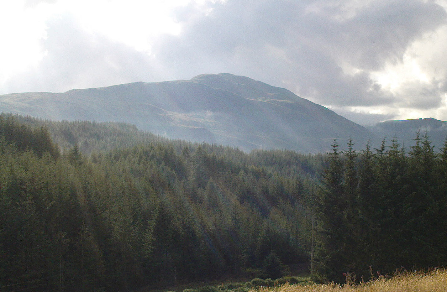
The hazy peak of Ben Ledi

From the tourist-infested (but lovely) town of Callander, look west to the largest of the nearby mountains — that’s where you’re heading!  You can keep along the A84 road out of the town for 4-5 miles (past the Falls and Pass of Leny) till you reach the parking spot on your left.  Cross the river and go up into the signposted woodland.  Keep walking up thru the trees until the rocky mass emerges above you.  You can either keep to the path and follow the long walk round the mountain, or go straight up the crags above you.  The top’s in sight!

Folklore

Getting up here is no easy task if you’re unfit — but it’s well worth the effort for the journey alone!  And in bygone centuries it seems, local people made it a particular pilgrimage at specific times during the year.  Even the name of this great hill has some supposed affinity with holy issues; though some modern english etymologists put a dampener on such things.  In Charles Rogers’ (1853) excellent Victorian exposition, he told that,

Benledi is an abbreviation of the Celtic Ben-le-dia, signifying the hill of God.”

But whether the old heathens who named most of these ancient mountains would echo his oft-repeated derivation is another thing altogether!  However, there are other decidedly pre-christian events that used to be enacted here, for the summit of Ben Ledi was, tradition tells, where the sun god was worshipped.  It would seem, however, that this tradition is a somewhat watered-down version of it as a site of cosmological and social renewal. (see Eliade 1974) For akin to the annual pilgrimage that happens upon Croagh Patrick in County Mayo, Ireland, here upon Ben Ledi,

“For three days and three nights…the inhabitants of the district in those primitive times convened, at the period of summer solstice, on the summit of the mountain, to join in the rites of heathen worship.”

More recent lore tells the date of such sacred gatherings was Beltane.  Also a short distance to the north of the summit of Ben Ledi is a small loch known as Lochan-nan-corp.  Mr Rogers again tells us that,

“Here two hundred persons, who were accompanying a funeral from Glenfinglas to the churchyard of St. Bride, suddenly perished; the ground had been covered with snow and the company were crossing the lake on the ice, when it at once gave way.”

It seems a most unusual event.  But the tale itself implies that a corpse route passed by the way of this high summit, down to the heathen chapel of St. Bride at the bottom of its eastern face: a huge undertaking in itself with probably archaic origins.  Does anyone know owt more about this?

References:

  1. Eliade, Mircea, The Myth of the Eternal Return, Princeton University Press 1974.
  2. Eliade, Mircea, Patterns in Comparative Religion, Sheed & Ward: London 1958.
  3. Roger, Charles, A Week at Bridge of Allan, Adam & Charles Black: Edinburgh 1853.

© Paul Bennett, The Northern Antiquarian


Allt na Ceardaich Knoll, Killin, Perthshire

Cup-Marked Stone:  OS Grid Reference – NN 564 364

Getting Here

Truly troublesome if you aint into walking.  Many ways up, but the easiest has to be the zigzagging trackway up from the valley bottom just by The Green a few hundred yards past Lochay Power Station, up the southern edge of Creag na Cailleach. At the end of the trackway, take the stream uphill for a few hundred yards and watch out for the rocky rise to your right (east).  Head for it and check out the rocks there.  You’ll find it!

Archaeology & History

Allt na Ceardaich01
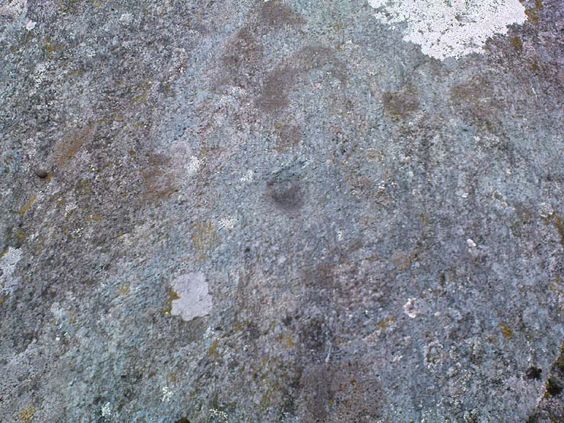
Single cup-marked rock below Creag na Cailleach

I’m not sure that anything’s previously been written about this curious single cup-marked boulder. I say ‘curious’, simply because of the location and position of the clear cup-mark on this near-gigantic piece of embedded stone.  We walked upon the rocky outcrop south of Creag na Cailleach (above the tree-line where the land levels out) and first saw the cup-marking at the top-end of this huge rock (amidst a number of others) on the large rise a coupla hundred yards west of Allt na Ceardaich.  And as the carved cup was on the top-end of the boulder, I was expecting to find much more of the rock with other motifs scattering its body — but was amazed to find that this was the only single cup-marking on an otherwise huge stone.  A mixture of bewilderment and disappointment came over me as I shook my head in disbelief that only a single cup had been scribed into an otherwise massive rock.

Allt na Ceardaich02
Close-up of the cup-marking

However, the light was poor with low cloud and it was nearing sunset, so there may have been other aspects to this carving which we missed out on.  One other ‘possible’ cup-mark might have been done, but it seemed very dubious even in the poor light.  I was all for having another look at it the following day; but wandering halfway up a mountain just to see if this was the only cup-marking on this outcrop was summat my daughter wasn’t into doing!  So the site must await another mad cup-and-ring-crazed traveller on another day to get a more detailed inspection!  George – are you out there anytime soon!?

© Paul Bennett, The Northern Antiquarian


Creag na Cailleach, Killin, Perthshire

Sacred Mountain:  OS Grid Reference – NN 5640 3715

Also known as:

  1. Creag na Caillich

Getting Here

Another silly-sounding directional pointer!  Get to the now tourist-infested town of Killin (best in Winter, when the town is quiet and you get to know the locals a lot better) and travel through it as if you’re going to follow Loch Tay up its western side.  As you’re going out of the village towards the Bridge of Lochay Hotel (an excellent place), you’ll see an amphitheatre of mountains in the background.  The tallest of the hills on the left is where you’re heading.  Go straight up the hillside and follow your nose!

Creag na Cailleach, Perthshire
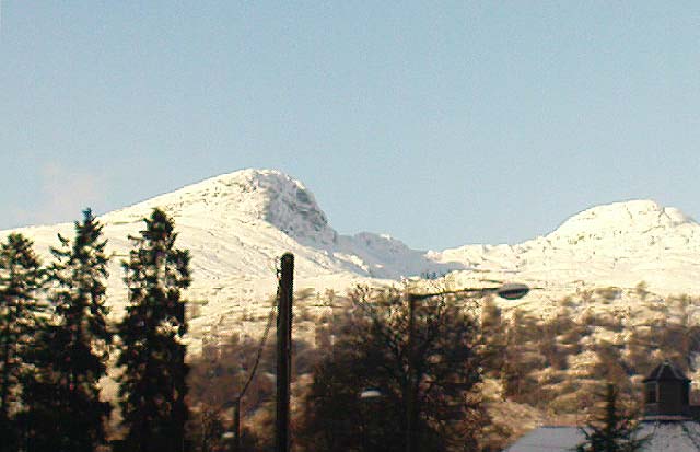
Creag na Cailleach, Killin

The hill guards the entrance to the legendary Glen Lochay (Valley of the Black Goddess).  There are many ways to climb her, but my first venture here took me up the waterfalls and steepish burn of Allt na Ceardaich.  Once on the level, I found myself surrounded by that amphitheatre I mentioned, from which – on my first visit – I took up the sheer face of this great mountain. (to be honest it’s nowt special if you’re into mountaineering and stuff) From the tops you’ve got a damn good view all round.  But respect this old hill, as danger awakens to idiots who would think themselves champions.

Folklore

Here, where axes were quarried by ancient man from beneath Her rocky slopes, this ‘Hill of the Old Woman’, or ‘Hag’, was one of the abodes of the primal Mother Goddess in olden times, so says her name.  Her ‘dark’ aspect seemed manifest one time when I climbed her with a rather stupid man in tow.  Following one of the streams back into the valley below, he thought it wise to copy my gazelle-nature as I sprang without thought, quickly, from rock to rock, bouncing at speed down the fast-flowing stream  (which takes a lotta weird practice and very strong ankles!), in spite of the advice to do otherwise – and in doing so he broke his leg in three places and, to make it worse, had to spend the night there in complete agony!

Don’t tell me there’s no ‘dark’ goddess to some of these great places!

Axe production has been found to have occurred as early as 2500 BC.  There have been numerous flint finds hereabouts aswell – but considering this is a mountain, you’d expect to find something on or about Her slopes!

I’ve just been back up here as the first good snow fell upon the hills and the white cover brought the elements out of her form in a way I’d not seen before.  Tis a wonderful place the Creag na Cailleach; and, it seems, a site that played a now forgotten part in the ancient name of the glen, Lochay, which was the living abode of the Black Goddess in more archaic days.  Twouldst be good to hear some of the authentic old stories from old locals that were once known of this ancient deity in the glens.  If anyone knows of such tales, let us know before they are lost forever…

References:

  1. Ritchie, P.R., ‘The Stone Implement Trade in Third Millenium Scotland,’ in Coles & Simpson’s, Studies in Ancient Europe, Leicester University Press 1968.

Acknowledgements:  Huge thanks to Lindsay Campbell for her hospitality, food and roof hereby.

© Paul Bennett, The Northern Antiquarian