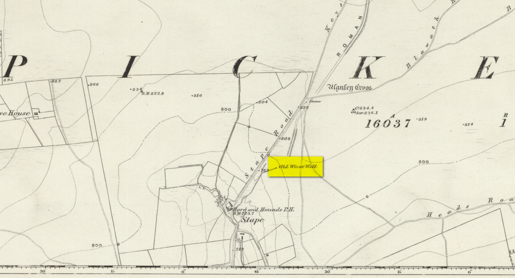
The history of the site is scanty to say the least. It first seems to have been recorded when the Ordnance Survey lads came here in the 1840s, although they left no record as to why the site was given such a dedication. It’s a decidedly pre-christian title as the name “old Wife” is usually indicative in northern counties as being related to the primal Earth deity of northern England and lowland Scotland (when we reach the Highlands and Ireland, She becomes known—amongst other names—as the cailleach). However, apart from its name we have no additional information. Neither the holy wells writer Edna Whelan (1989; 2001), nor hydrolatry researcher Graeme Chappell were been able to find anything about the place in their own researches. And so we must go on name alone…
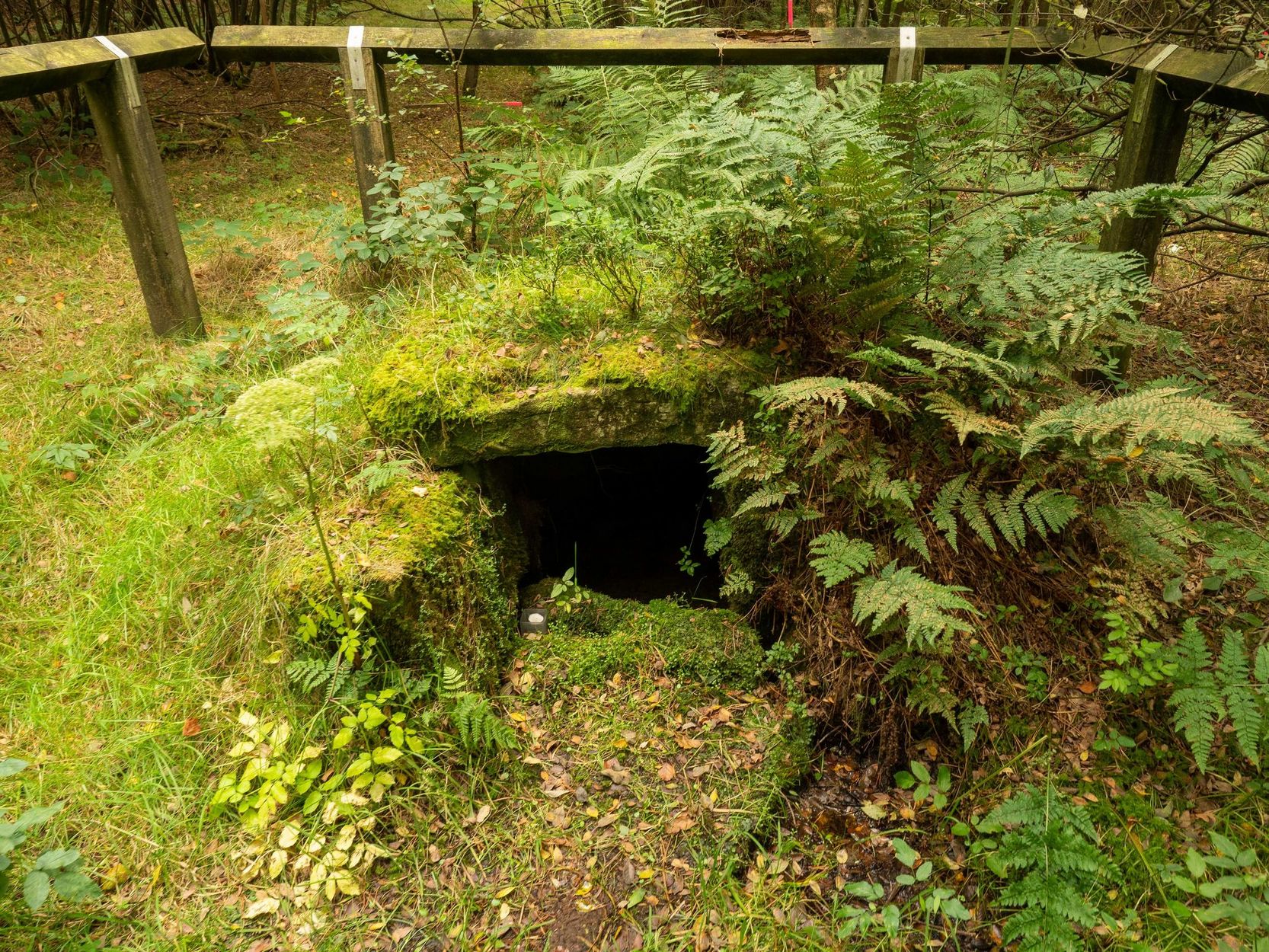
The waters bubble up into a small stone-lined chamber with the words Nattie Fontein carved into the lintel. This is something of a mystery in itself, for, as Edna Whelan (1989) told,
“it would be most unusual for the word fonten to be used for a spring in North Yorkshire: ‘keld’ is the local word. The rather roughly inscribed word may be a corruption of Fons Natalis, the name of a Celtic water nymph.”
Graeme Chappell (2000) meanwhile, noticed in a visit to the site in June 1999,
“that the N and A in “NATTIE” are carved in such a way that the word could be read as “MATTIE FONTEIN” perhaps meaning “Mother Fountain”. This might then be another reference to the Old Wife?”
He then goes on to note how,
“the latin word ‘natalis‘ meaning ‘birth’ and its link with the roman Festival ‘Dies Natalis Sol Invictus‘ (day of the birth of the unconquered sun) which took place on the 25th December. Natalis also gave rise to the welsh word ‘Nadolig‘ – meaning Christmas.”
This Yuletide element has an intriguing relationship with the name of the well; for to the west of Yorkshire’s borders into Cumbria there was annual gathering known as Old Wives’ Saturday that took place on the first Saturday after Christmas, or first Saturday of the New Year in a person’s house or inn, where a feast was had to bring in the New Year; but there is no known written lore of such a tradition here.
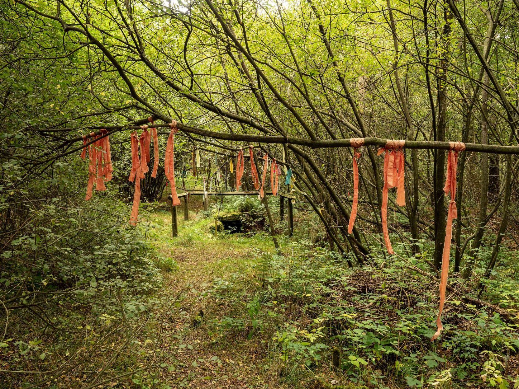
Nowadays the old tradition of hanging rags on the trees surrounding the well as offerings to the spirit of the place (known as memaws in parts of Yorkshire, and clooties in Scotland) has become a regular practice of those who hold such sites as sacred in their own way. Whelan mentioned seeing memaws here in the 1908s, but the Northern Antiquarian contributor Jon Barker told that, “The rags are a comparatively recent addition to the well, it is not a tradition there. When I used to go in the ’60s therewere no rags.”
On an even more curious note: very recently (from when this profile was written), the Northern Antiquarian contributor and photographer James Elkington visited Old Wives’ Well for the first time. It was a grey overcast day and when he arrived here, there was a woman ahead of him at the head of the well. I’ll let him tell the rest of it in his own words:
The Old Wives Well, Stape (James Elkington)Old Wives Well at Stape (James Elkington)
“In front of the well was a lady dressed in what looked like a white nighty, she had her back to me. There was a candle lit nearby, and her hands were in the water moving slowly about like she was washing something. She had long dark shoulder length hair. As I was about 25 feet away I was sure she wasn’t aware of me, and I thought it would make a good photograph. I quietly put my bag on the ground and got my camera out, and looked up and…she was gone! I couldn’t have taken my eye off her for more than 5 or 6 seconds. I looked all around and there was no sign of her. Even if she had legged it through the woods I would have seen her. I think it was then that I realized that I may have had ‘an encounter’. I quickly took three pics of the Well and got the hell out of there!”
He rang me once he had regained his senses in a somewhat emotional state and recounted over and over what had just happened. Whether this was a visual manifestation of the genius loci of the we can’t say. But such encounters are not unknown at numerous sacred water sites all over the world. We can only hazard a guess that this is what he was fortunate to encounter.
Just a few hundred yards north is the old Mauley or Malo Cross, which may or may not have had some mythic relationship with our Old Wives…
Take the same route as if you’re visiting the small Carlin Stone (a few hundred yards further along): along the B822 road between Kippen and Fintry, stop at Balafark farm and cross the road above the farm to take the track into the forest. 1km along, note the small green track, off the main central track, slightly up on the rise on your right, which bends round and then goes (eventually) to the other side of the forest. Once you reach the gate at its edge, walk left 285 yards (261m) along the fence.
Archaeology & History
The Wife and the Carlin on the 1865 OS-map
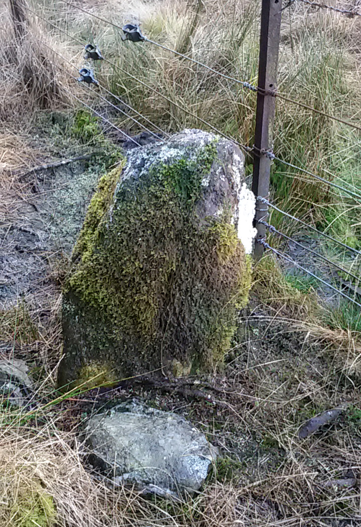
Described in the Ordnance Survey’s (1870) Book of Reference (volume 47) as “a flat rock on the boundary between Perth and Stirling,” the rock is certainly not flat—and any geographical relationship it had with Perth has long since gone. Instead, the stone in question here is an upright one—although it’s not much more than two feet tall. However, on the other side of the present-day fence there is a small flat stone in the ground; but it is the moss-covered upright that is our ‘Wife with the Bratty Plaid.’ A smaller curious-looking quartz-lined stone also lies next to this old Wife…
The Wife, looking east
The Wife, looking west
Marked on the ancient boundary line, this small but sturdy standing stone probably has a prehistoric pedigree, although we cannot be certain without an excavation. It is shown on the earliest OS-maps from the 1860s, but we have no notifications from any literary sources telling the tale behind the stone’s fascinating name: meaning simply, the ‘wife wearing the tartan shawl.’ When Marion Woolley and I came here the other day, we tried to see if a simulacrum of such a figure was hiding in the moss-covered upright—but unlike the notable simulacrum at MacBeth’s Stone, we struggled somewhat here. It was possible, from certain angles (if we didn’t stand on our heads and poke each other in the eyes!) to see this ‘wife in a shawl’, but twas a struggle…
There’s every likelihood that whatever the old tale once was about this petrified ancestral stone, it would have had some mythic relationship with the Old Wife known as the Carlin, or cailleach, a few hundred yards to the west, at the Carlin Stone. As yet however, their histories remain hidden in the sleep of the Earth…
Take the B822 road between Kippen and Fintry, stopping at Balafark farm. On the other side of the road, above the farm, take the track into the forest. Naathen…. 1120 yards (1.02km) along, note the small green track, off the main central track, slightly up on the rise on your right. It bends round and then goes (eventually) straight to the edge of the forest. Once you reach the edge, go left all along the fence until it meets the large gate 800 yards WSW. 20 yards past the gate, a small stone is along the fence-line. This is the Carlin!
Archaeology & History
Carling Stone, looking east
Found along the same boundary line as another stone with similar mythic virtues (called the ‘Wife with the Bratty Plaid’), when Marion Grace Woolley and I visited the site earlier, we found only a small upright, barely a foot tall, right in line with the ancient boundary along a newly made fence. Thankfully, whoever built the fence, understood the nature of the stone, and left it in the ground where it belongs. We know not for sure exactly how old this stone might be, but it its name and position suggest very old – probably prehistoric.
The Carlin is another word for the Cailleach: the prima mater or great Earth goddess in Irish, Scottish and northern English animistic traditions. Her virtues are immense, representing the cycles of the natural world, a creation giant, healer and a whole host of other elements inherent to the natural world. Although She tends to be represented as the Winter hag, the Cailleach changes Her faces and attributes as the cloaks of the seasons go by, annually, cyclically, year after year after year. She’s as much the cloak of the Winter as She is the fertility of Spring, the warmth of the Summer and the fruits of Autumn.
Carling Stone, looking west
Whatever traditions there might have been at this small Carlin Stone are now long forgotten it seems. We find no bodach (Her husband) in immediate attendance. However, the existence of the small standing stone called the ‘Wife with the Bratty Plaid,’ several hundred yards to the east along the same ancient boundary line, implies there would have been a traditional perambulation along this boundary, and during such annual ritual walks, tales or words may have been said here. Does anyone know more…?
Standing Stone? (destroyed): OS Grid Reference – SE 2428 2329
Archaeology & History
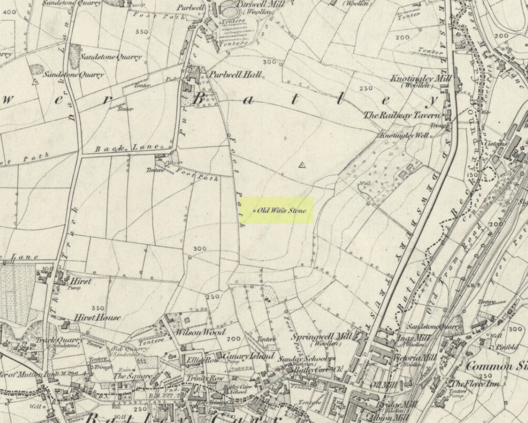
Old Wifes Stone on 1854 map
My first hint at the existence of this once valuable archaeological relic came as a result of me seeking out the history and folklore of some hitherto unknown, forgotten holy wells in the Batley and Dewsbury area. I located the material I was looking for on the old wells, but my fortuitous discovery of this site, the Old Wife’s Stone, blew me away!
It was the place-name of ‘Carlinghow’ about one mile northwest of the grid-reference above that initially caught my attention. From an antiquarian or occultist’s viewpoint, it’s intriguing on two counts: the first is the element ‘how‘ in Carlinghow, which can mean a variety of things, but across the Pennines tends to relate to either an ancient tribal or council meeting place, or a prehistoric burial cairn: an element that wasn’t lost in the giant archaeology survey of West Yorkshire by Faull & Moorhouse (1981). But the first part of this place-name, ‘carling‘, was the exciting element to me; for it means ‘old woman,’ ‘old hag,’ ‘witch’ or cailleach! The cailleach (to those who don’t know) was the prima mater: the Great Mother deity of our pre-christian British ancestors. Meaning that Carlinghow hill was a hugely important sacred site no less—right in the heart of industrial West Yorkshire! What is even more intriguing—or perhaps surprising—is that we have no record of such a powerful mythic creature anywhere in local folklore… Or so it first seemed…
Memory told me that no such prehistoric remains were recorded anywhere in that area—and certainly no prehistoric tombs. I scoured through my library just to triple-check, and found the archaeological records as silent as I first thought. Just to make sure I spent a day at the Central Library, where again I found nothing… So then I explored the region on the modern OS-maps, only to find that much of the area where the Carlinghow place-name existed was, surprisingly, still untouched by housing and similar modern pollutants. This was a great surprise to say the least. And so to check for any potential archaeological sites which might once have been in the Carlinghow area, I turned to the large-scale 1850 OS-maps (6-inch to the mile).
This is when I came across the Old Wife’s Stone, marked in the middle of fields on the outskirts of old Batley. There was no notice of it being a standing stone, or a simple boulder, or archaeological relic—nothing. But its place-name compatriot of ‘Carlinghow’ was the rising hill about a mile to the northwest. In days of olde, if Carlinghow was indeed the ‘burial tomb of the Old Woman’ or ‘meeting place of the cailleach’ (or whatever variants on the theme it may have been), it may have marked the setting sun on the longest day of the year if you had been standing at the Old Wife’s Stone – a midsummer sunset marker no less. (There are other ancient and legendary sites scattering northern England and beyond that are dedicated to the Cailleach, like the Old Woman Stone in Derbyshire, the Old Wife’s Neck in North Yorkshire, the Carlin Stone in Stirlingshire, the Old Woman Stone at Todmorden, Carlin Stone of Loch Elrig and many more.)
As if these curious ingredients weren’t enough to imply something existed in the heathen pantheon of Batley before the Industrialists swept away our indigenous history, we find echoes of the ‘Old Woman’ yet again, immediately east; this time where the animism of water and trees enfolded Her mythos in local rites and traditions, thankfully captured by the pens of several writers, and transmuted into another guise—but undeniably Her! But that, as they say, is for another day and another site profile…
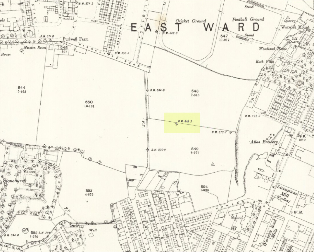
Position of stone in 1894
So is our Old Wife’s Stone (or for that matter, Carlinghow’s old tomb) still in evidence? A school has been built where it was highlighted on the 1854 OS-map and, from the accounts of local people, seems to have long since disappeared. The stone looks to have been incorporated into a length of walling, sometime between 1854 and 1888, and a bench-mark of “BM 318.2” carved onto it. But when the Ordnance Survey lads re-surveyed the area in 1905, this had gone. I have been unable to find any more information about this site and hope that, one day, a fellow antiquarian or occult historian might be able to unravel more of its forgotten mythic history.
References:
Faull, M.L. & Moorhouse, S.A. (eds), West Yorkshire: An Archaeological Survey to 1500 AD – volume 1, WYMCC: Wakefield 1981.
Goodall, Armitage, Place-Names of South-west Yorkshire, Cambridge University Press 1914.
Keighley, J.J., ‘The Prehistoric Period’, in Faull & Moorhouse, 1981.
o’ Crualaoich, Gearoid, The Book of the Cailleach, Cork University Press 2004.
Smith, A.H., English Place-Name Elements – volume 2, Cambridge University Press 1956.
Smith, A.H., The Place-Names of the West Riding of Yorkshire – volume 2, Cambridge University Press 1961.
Wright, Joseph, English Dialect Dictionary – volume 1, Henry Frowde: London 1898.
Acknowledgements: Many thanks for the assistance of Simon Roadnight and Julia King in the Batley History Group.
Sacred Well (destroyed): OS Grid Reference – NO 32898 50521
Also Known as:
Carling Well
Archaeology & History
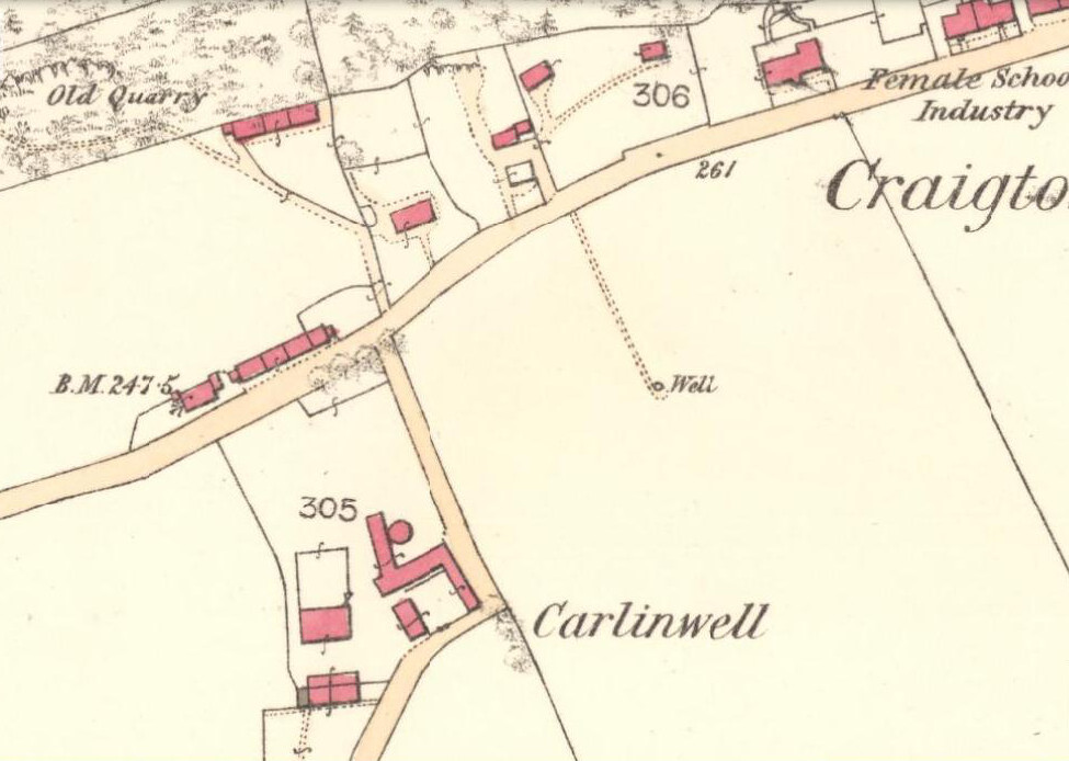
Carlin Well on the 1865 OS-map
Also known as the Carling Well, this place was shown on the earliest Ordnance Survey maps near the middle of the field next to Carlinwell Farm. On that map (as we see here) the water source had a singular track leading straight from the road to the well and no further. But by 1900 both the track and the well had been covered over and seemingly destroyed. A great pity…for if the place-name and dialect analysis is correct, this was once another sincere site dedicated to the cailleach, or Old Woman, or witch of Gaelic legend: the prima Mater of indigenous Scottish, Irish and northern myth.
The dip in the field where Carlin Well once appeared
The word “carlin/g” is explored in some detail in William Grant’s (1941) magnum opus, giving all possible derivations as found in Scotland. Whilst one definition relates the word to being “the last sheaf of corn in the harvest field”, this element relates to the wider mythic virtues of the cailleach Herself. It’s general form relates specifically to a “woman, generally an old woman and often in a disparaging sense”; aswell as “properly an old crone, but now generally in sense of a big woman.” Again, these are attributes central to the cailleach Herself. The derivation of “a witch” is widely known, and is a term used across the northern lands in stories of pre-christian lore and Creation Myths, specific to the cailleach. One more derivation tells of the word relating to a corruption of Yule plays (possibly relating once again to Nature’s cyclical traditions as enacted by our peasant ancestors which would once more have been attributed to the cailleach) and another saying how the word was used as a derogatory term to insult men!
But unless good evidence to the contrary can be show, this covered site is, in all probability, another example of a place that was dedicated to the primary heathen female deity, or Earth goddess, as She was known throughout the northern lands of England and Scotland.
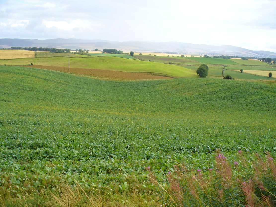
Carling Well field, looking north
The field in which the well once emerged has a distinct ‘bowl’ shape to it, exactly where the Carlin Well is shown on the map—and this large bowl can be seen clearly from the A926 road above, as shown in the photo here. When we visited the site a week ago, the field was still full of crops so we didn’t explore the site; and we could find no one at the adjacent farm of the same name, who we hoped might have been able to give us further information. If anyone has any further information about the place, please let us know!
References:
Grant, William (ed.), The Scottish National Dictionary – volume 2, SNDA: Edinburgh 1941.