Holy Well (destroyed): OS Grid Reference – NS 6983 4138
Archaeology & History
St Brides Chapel & Well on the 1864 OS-map
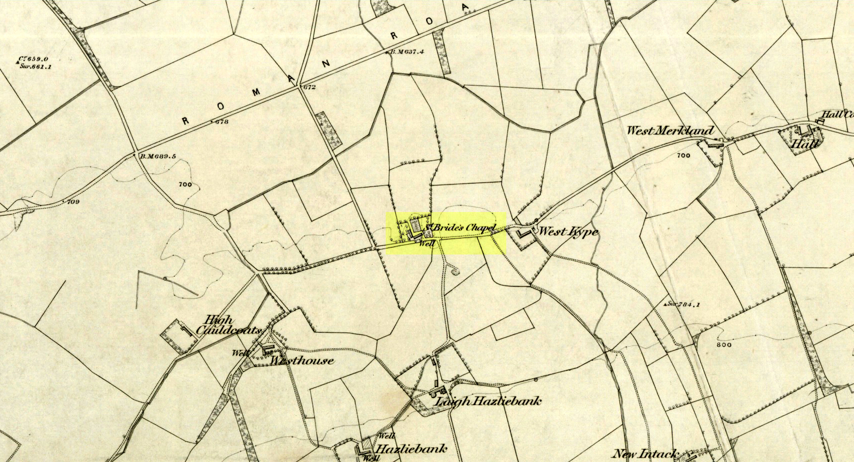
Shown on the 1864 OS map of the area as a ‘Well’ just at the front of St Bride’s Chapel—now a very pleasant old cottage—peasants and pilgrims would stop for both refreshment and ritual here as they walked down High Kype Road. Although the chapel was described in church records of January 1542 as being on the lands of Little Kype, close to the settlement of St Bride, there seems to be very little known about the history or traditions of the well. If anyone has further information on this site, please let us know.
Folklore
Bride or Brigit has her origins in early British myth and legend, primarily from Scotland and Ireland. Her saint’s day is February 1, or the heathen Imbolc (also known as Candlemas). Although in christian lore St. Bride was born around 450 AD in Ireland and her father a Prince of Ulster, legend tells that her step-father (more probably a teacher) was a druid and her ‘saintly’ abilities as they were later described are simply attributes from this shamanic pantheon. Legends—christian and otherwise—describe Her as the friend of animals; possessor of a magickal cloak; a magickian and a healer; and whose ‘spirit’ or genius loci became attached to ‘sacred sites’ in the natural world, not the christian renunciation of it. St Bride was one of the primal faces of the great prima Mater known as the Cailleach: the greater Gaelic deity of Earth’s natural cycles, whose changing seasons would also alter Her names, faces and clothes, as Her body moved annually through the rhythms of the year. Bride was (and is) ostensibly an ecological deity, with humans intrinsically a part of such a model, not a part from it, in contrast to the flawed judaeo-christian theology.
References:
Paul, J.B. & Thomson, J.M., Registrum Magni Sigilli Regum Scotorum: The Register of the Great Seal of Scotland AD 1513 – 1546, HMGRH: Edinburgh 1883.
This long lost ‘holy well of St Brigit’ (Tobar Bhride) has been mentioned—purely in literary repetition—by such folklore giants as F.M. MacNeill and others, but none of them give any additional information about it than that first mentioned by Alexander Stewart’s (1890) in his fascinating article on magical stones. Indeed, knowledge of this well’s very existence was only preserved thanks to a ritual incantation that was recited to imbue and maintain healing properties of one such magickal stone, known as the Charm Stone of Keppoch. It
“was an oval of rock crystal, about the size of a small egg, fixed in a bird’s claw of silver, and with a silver chain attached, by which it was suspended when about to be dipped.”
It was dipped in water taken from the sacred well of St Brigit, somewhere not far from Keppoch. The incantation made over the stone was in Gaelic, obviously, but the english translation is:
“Let me dip thee in the water,
Thou yellow, beautiful gem of Power!
In water of purest wave,
Which (saint) Bridget didn’t permit to be contaminated.
In the name of the Apostles twelve,
In the name of Mary, virgin of virtues,
And in the name of the high trinity
And all the shining angels,
A blessing on the gem,
A blessing on the water, and
A healing of bodily ailments to each suffering creature.”
On the east side of the river, just a few hundred yards away, could once be found the Fuaran na Ban-Tighearna, or the Well of Her Ladyship. In this sense, the term ‘ladyship’ refers to the “wife of a baronet or knight.” (Dwelly 1918) The idea that it may refer to Bride in Her guise as a ‘lady’ is linguistically improbable here (though not impossible). Also, if this fuaran did have a geomythic relationship with Bride, we would expect to find a Cailleach in the nearby landscape, which we don’t.
Folklore
An interesting piece of folklore that may relate to this well is described by the great Scottish landscape wanderer, Seton Gordon. (1948) Although he makes no mention of a Bride’s Well, there is the tale of a missing bride up Glen Roy, of which Keppoch sits below. “It was in earlier times,” he wrote,
“that the Maid of Keppoch was taken by the fairies in Glen Roy. She was an Irish girl, little more than a child, and had become the wife of MacDonell of Keppoch. But the wedding rejoicings were scarcely over when the bride, wandering into the oak woods which still clothe the lower slopes of Glen Roy, disappeared mysteriously. It was believed that, like the Rev Robert Kirk…she had been spirited away by the fairies. If indeed she was abducted by the Little People they held her closely, for from that day to this no trace has been found of the fair Maid of Keppoch.”
St Bride of course was Irish, like the Maid of Keppoch. And just a mile up Glen Roy from Keppoch House we find the Sron Dubh and Sithean, or Ridge of the Dark Fairy Folk. There are several burns (streams) running either side and below this fairy haunt, but I can find none with Bride’s name. Someone, somewhere, must know where it is…
References:
Gordon, Seton, Highways and Byways in the Central Highlands, MacMillan: London 1948.
Dwelly, Edward, The Illustrated Gaelic English Dictionary – volume 1, Fleet Hants 1918.
Stewart, Alexander, “Notice of a Highland Charm-Stone,” in Proceedings Society Antiquaries, Scotland, volume 24, 1890.
Holy Well (covered): OS Grid Reference – TQ 3157 8111
Archaeology & History
St Brides Well on 1896 map
Close to the centre of that corporate money-laundering place of homo-profanus that is the City of London, was once a site that represents the antithesis of what it has become. Tacked onto the southeastern side of St. Bride’s church along the appropriately-named Bride Lane, the historian Michael Harrison (1971) thought the Holy Well here had Roman origins. It “was almost certainly,” he thought,
“in Roman times, the horrea Braduales, named after the man who probably ordered their construction: Marcus Appius Bradua, Legate of Britain under Hadrian, and the British Governer in whose term of office the total walling of London was, in all likelihood, begun.”
This ‘Roman marketplace of Bradua’ that Harrison describes isn’t the general idea of the place though. Prior to the church being built, in the times of King John and Henry III, the sovereigns of England were lodged at the Bridewell Palace, as it was known. Mentioned in John Stow’s (1720) Survey of London, he told:
“This house of St. Bride’s of later time, being left, and not used by the Kings, fell to ruin… and only a fayre well remained here.”
The palace was eventually usurped by the building of St. Bride’s church. The most detailed account we have of St. Bride’s Well is Alfred Foord’s (1910) magnum opus on London’s water supplies. He told:
“The well was near the church dedicated to St. Bridget (of which Bride is a corruption; a Scottish or Irish saint who flourished in the 6th century), and was one of the holy wells or springs so numerous in London, the waters of which were supposed to possess peculiar virtues if taken at particular times. Whether the Well of St. Bride was so called after the church, or whether, being already there, it gave its name to it, is uncertain, more especially as the date of the erection of the first church of St. Bride is not known and no mention of it has been discovered prior to the year 1222. The position of the ancient well is said to have been identical with that of the pump in a niche in the eastern wall of the churchyard overhanging Bride Lane. William Hone, in his Every-Day Book for 1831, thus relates how the well became exhausted: ‘The last public use of the water of St. Bride’s well drained it so much that the inhabitants of the parish could not get their usual supply. This exhaustion was caused by a sudden demand on the occasion of King George IV being crowned at Westminster in July 1821. Mr Walker, of the hotel No.10 Bridge Street, Blackfriars, engaged a number of men in filling thousands of bottles with the sanctified fluid from the cast-iron pump over St. Bride’s Well, in Bride Lane.” Beyond this there is little else to tell about the well itself, but the spot is hallowed by the poet Milton, who, as his nephew, Edward Philips records, lodged in the churchyard on his return from Italy, about August 1640, “at the house of one Russel a taylor.”
In Mr Sunderland’s (1915) survey, he reported that “the spring had a sweet flavour.”
Sadly the waters here have long since been covered over. A pity… We know how allergic the city-minds of officials in London are to Nature (especially fresh water springs), but it would be good if they could restore this sacred water site and bring it back to life.
Folklore
Bride or Brigit has her origins in early British myth and legend, primarily from Scotland and Ireland. Her saint’s day is February 1, or the heathen Imbolc (also known as Candlemas). Although in christian lore St. Bride was born around 450 AD in Ireland and her father a Prince of Ulster, legend tells that her step-father (more probably a teacher) was a druid and her ‘saintly’ abilities as they were later described are simply attributes from this shamanic pantheon. Legends—christian and otherwise—describe Her as the friend of animals; possessor of a magickal cloak; a magickian and a healer; and whose ‘spirit’ or genius loci became attached to ‘sacred sites’ in the natural world, not the christian renunciation of it. St Bride was one of the primal faces of the great prima Materknown as the Cailleach: the Gaelic deity of Earth’s natural cycles, whose changing seasons would also alter her names, faces and clothes, as Her body moved annually through the rhythms of the year. Bride was (and is) ostensibly an ecological deity, with humans intrinsically a part of such a model, not a part from it, in contrast to the flawed judaeo-christian theology.
References:
Foord, Alfred Stanley, Springs, Streams and Spas of London: History and Association, T. Fisher Unwin: London 1910.
Gregory, Lady, A Book of Saints and Wonders, Colin Smythe: Gerrards Cross 1971.
Harrison, Michael, The London that was Rome, Allen & Unwin: London 1971.
McNeill, F. Marian, The Silver Bough – volume 2, William MacLellan: Glasgow 1959.
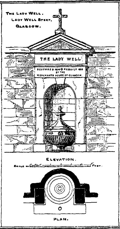
Get yourself to Glasgow Cathedral—wherein you’ll find St. Mungo’s Well—and walk down John Know Street. A coupla hundred yards down, across the road is a small street called Ladywell Lane (there’s no signpost for it though), running below the cemetery and leading to the back entrance of the giant Tennent’s Brewery. At the bottom of this, up against the wall on your left, is the Lady Well.
Archaeology & History
The origins and early traditional history of this once famous sacred well are sadly lost due to the intrusion of industrialism. It was obviously a place of some considerable repute and lent its name to local quarries and fields hereby. Used extensively by local people for countless centuries, things were to change in 1715 when the waters of this and other wells were to be kept clean by one John Black, “at a salary of 400 merks yearly.” The Glasgow historian Eyre-Todd (1934) told that,
“Black was to furnish them with chains, buckets, sheaves, ladles, and other necessary graith, aswell as with locks and iron bands. He was ‘to cleanse, muck and keep them clean,’ and to lock and open them in due time, evening and morning. In case of failure he was liable to a penalty of £100 Scots.”
Lady Well in 2015
Lady Well in 1883
That’s a helluva lot of money in those days! Even when M’Ure (1736) described it, only in passing, he had nothing to say about its curative properties or local rites. Once the Industrialists take control, the ways of local people are sanitized, sterilized and ‘progress’ outlaws tradition. The only reference to an earlier sacrality is in Mr Russel’s (1883) article, where he said simply, that the Lady Well was “so called after a fountain at the bottom of the Craigs…sacred in Popish times to the Virgin.”
The construction that we see today—of the well in its little enclave—was first built in 1835-6. The waters became polluted after they were redirected below the Necropolis and have not been used since (although they still flow out of the wall a couple of yards to the right, stinking!). The architectural feature was cleaned up and restored by the local brewery in 1983.
The site may have gained its name from one Lady Lochow, who lived nearby and built a hospital at the old Gorbels in the 14th century—but we might never know the real truth about the origin of its dedication. However, an intriguing ingredient relating to the dedication of the Lady Well is the incidence of a St. Anne’s Street that used to exist immediately to the east, as seen on the 1865 OS-map above. St. Anne may well be the mythic character behind the naming of this Lady Well, although I can find no literature to prove this. In the christian mythos, St. Anne was a very important character indeed: the mother of the Virgin Mary no less! However, as hagiographers from Attwater (1965), to Baring-Gould (1898) and Butler (1866) all tell, her biography is piecemeal—which is most surprising considering she was JC’s granny! Anne’s festival date was July 26 (a couple of days after Sirius enters the northern hemisphere); she was the patron saint of midwives, grandmothers and also miners, who invoked her as the deity who produced gold and silver—akin to the Earth Mother Herself! It’s obvious that Anne’s original mythic nature was subdued, as she represented an archaic root of matriarchal triplicity of the Virgin, the Lady and Old Woman and not the patriarchal triplicity of the incoming christian cult. The christian mythos at this Lady Well (as elsewhere) replaced one facet of the indigenous prima mater in Glasgow, known as the Cailleach—as shown in her attributes of midwife, grandmother and the deep Earth. If local historians can find field-names or wells dedicated to the Maiden, the Lady and the Carlin (or their variant titles) nearby, the lost layers of archaic Glasgow’s indigenous animistic folk memories could be mapped out once again…
References:
Attwater, Donald, The Penguin Dictionary of Saints, Penguin: Harmondsworth 1965.
Seems rather daft giving directions for a mountain, but… For incomers, cross the bridge onto the island and keep on the A87 road to Broadford. A couple of mile the other side of the village westwards, take the small left turn in the trees and go to the dead-end. The hill reaching up above you (west) is the legendary mountain to walk up!
Folklore
Beinn na Cailleach
This giant old mountain has been associated with the primal female creation figure, the cailleach, for many a moon. And strangely – for me anyway – I’ve not ventured to sleep with this old place in my passings here as I usually do wherever the cailleach resides.
It doubtless has many more tales than the one A.A. MacGregor (1937) mentions in his superb Peat-Fire Flame. Here he tells the story of,
“the cairn situated on the summit of Beinn na Cailleach, not far from Broadford… This cairn is believed to mark the site of burial of a Norse princess who died at Ord. On her deathbed this princess commanded her attendants to convey her, when dead to the top of Beinn na Cailleach, and to bury her there, in order that she might lie in the wake of the winds from Norway.”
MacGregor then follows the tale with a lovely note on some boring old dood he obviously had little respect for, saying:
“It is the traditions associated with this cairn that MacCulloch, the geologist, in his Description of the Western Isles of Scotland, asks to be excused from repeating, since he considers them, one and all, to be unworthy of regard. But, then, MacCulloch was a most tiresome fellow; and he seems to have imbued most of his writings with something of the same tiresomeness”!
On the lower northeastern slopes of this great mountain we find another of the old woman’s abodes, the ‘Lochain Beinn na Cailleach’, where this great hag would no doubt wash her linen, as many old myths tell she did at other pools of the same name.
A slightly different version of the folktale was told by Archibald Geikie in his Note-book of a Field Geologist from 1858:
“The top of Beinn na Cailleaich is flat and smooth, surmounted in the centre by a cairn. Tradition tells that beneath these stones there rest the bones of the nurse of a Norwegian princess. She had accompanied her mistress to “the misty hills of Skye,” and eventually died there. But the love of home continued strong with her to the end, for it was her last request that she might be buried on the top of Beinn na Cailleaich, that the clear northern breezes, coming fresh from the land of her childhood, might blow over her grave.”
An early essay in the Gentleman’s Magazine in 1841 tells the grave atop of the mountain to have been the resting place of the Norwegian King Haco’s wife or his nurse. Derek Cooper (1970) meanwhile told us that whilst the cairn was “erected as a memorial to a Skye chieftain,” the cailleach of the mountain, or “the old woman is reputedly Saucy Mary, who laid a chain between Kyle and Kyleakin to exact toll from passing ships.”
There are other mythic place-names scattered around the edges of this mountain with hints of ancient female deities, or pagan goddesses — whichever way one cares to see them.
References:
Cooper, Roy, Skye, Routledge: London 1970.
Geikie, Archibald, The Story of a Boulder, MacMillan: London 1858.
MacGregor, Alisdair Alpin, The Peat-Fire Flame: Folk-Tales and Traditions of the Highlands and Islands, Ettrick Press: Edinburgh 1937.
o’ Crualaoich, Gearoid, The Book of the Cailleach, Cork University Press 2003.
Swire, Otta F., Skye: The Island and its Legends, Blackie & Sons: London 1961.
Standing Stone? (destroyed): OS Grid Reference – SE 2428 2329
Archaeology & History
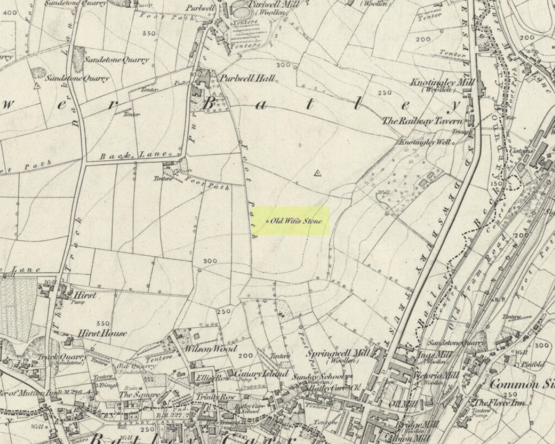
Old Wifes Stone on 1854 map
My first hint at the existence of this once valuable archaeological relic came as a result of me seeking out the history and folklore of some hitherto unknown, forgotten holy wells in the Batley and Dewsbury area. I located the material I was looking for on the old wells, but my fortuitous discovery of this site, the Old Wife’s Stone, blew me away!
It was the place-name of ‘Carlinghow’ about one mile northwest of the grid-reference above that initially caught my attention. From an antiquarian or occultist’s viewpoint, it’s intriguing on two counts: the first is the element ‘how‘ in Carlinghow, which can mean a variety of things, but across the Pennines tends to relate to either an ancient tribal or council meeting place, or a prehistoric burial cairn: an element that wasn’t lost in the giant archaeology survey of West Yorkshire by Faull & Moorhouse (1981). But the first part of this place-name, ‘carling‘, was the exciting element to me; for it means ‘old woman,’ ‘old hag,’ ‘witch’ or cailleach! The cailleach (to those who don’t know) was the prima mater: the Great Mother deity of our pre-christian British ancestors. Meaning that Carlinghow hill was a hugely important sacred site no less—right in the heart of industrial West Yorkshire! What is even more intriguing—or perhaps surprising—is that we have no record of such a powerful mythic creature anywhere in local folklore… Or so it first seemed…
Memory told me that no such prehistoric remains were recorded anywhere in that area—and certainly no prehistoric tombs. I scoured through my library just to triple-check, and found the archaeological records as silent as I first thought. Just to make sure I spent a day at the Central Library, where again I found nothing… So then I explored the region on the modern OS-maps, only to find that much of the area where the Carlinghow place-name existed was, surprisingly, still untouched by housing and similar modern pollutants. This was a great surprise to say the least. And so to check for any potential archaeological sites which might once have been in the Carlinghow area, I turned to the large-scale 1850 OS-maps (6-inch to the mile).
This is when I came across the Old Wife’s Stone, marked in the middle of fields on the outskirts of old Batley. There was no notice of it being a standing stone, or a simple boulder, or archaeological relic—nothing. But its place-name compatriot of ‘Carlinghow’ was the rising hill about a mile to the northwest. In days of olde, if Carlinghow was indeed the ‘burial tomb of the Old Woman’ or ‘meeting place of the cailleach’ (or whatever variants on the theme it may have been), it may have marked the setting sun on the longest day of the year if you had been standing at the Old Wife’s Stone – a midsummer sunset marker no less. (There are other ancient and legendary sites scattering northern England and beyond that are dedicated to the Cailleach, like the Old Woman Stone in Derbyshire, the Old Wife’s Neck in North Yorkshire, the Carlin Stone in Stirlingshire, the Old Woman Stone at Todmorden, Carlin Stone of Loch Elrig and many more.)
As if these curious ingredients weren’t enough to imply something existed in the heathen pantheon of Batley before the Industrialists swept away our indigenous history, we find echoes of the ‘Old Woman’ yet again, immediately east; this time where the animism of water and trees enfolded Her mythos in local rites and traditions, thankfully captured by the pens of several writers, and transmuted into another guise—but undeniably Her! But that, as they say, is for another day and another site profile…
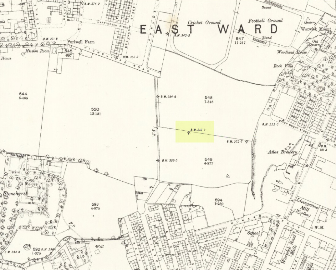
Position of stone in 1894
So is our Old Wife’s Stone (or for that matter, Carlinghow’s old tomb) still in evidence? A school has been built where it was highlighted on the 1854 OS-map and, from the accounts of local people, seems to have long since disappeared. The stone looks to have been incorporated into a length of walling, sometime between 1854 and 1888, and a bench-mark of “BM 318.2” carved onto it. But when the Ordnance Survey lads re-surveyed the area in 1905, this had gone. I have been unable to find any more information about this site and hope that, one day, a fellow antiquarian or occult historian might be able to unravel more of its forgotten mythic history.
References:
Faull, M.L. & Moorhouse, S.A. (eds), West Yorkshire: An Archaeological Survey to 1500 AD – volume 1, WYMCC: Wakefield 1981.
Goodall, Armitage, Place-Names of South-west Yorkshire, Cambridge University Press 1914.
Keighley, J.J., ‘The Prehistoric Period’, in Faull & Moorhouse, 1981.
o’ Crualaoich, Gearoid, The Book of the Cailleach, Cork University Press 2004.
Smith, A.H., English Place-Name Elements – volume 2, Cambridge University Press 1956.
Smith, A.H., The Place-Names of the West Riding of Yorkshire – volume 2, Cambridge University Press 1961.
Wright, Joseph, English Dialect Dictionary – volume 1, Henry Frowde: London 1898.
Acknowledgements: Many thanks for the assistance of Simon Roadnight and Julia King in the Batley History Group.
Truly troublesome if you aint into walking. Many ways up, but the easiest has to be the zigzagging trackway up from the valley bottom just by The Green a few hundred yards past Lochay Power Station, up the southern edge of Creag na Cailleach. At the end of the trackway, take the stream uphill for a few hundred yards and watch out for the rocky rise to your right (east). Head for it and check out the rocks there. You’ll find it!
Archaeology & History
Single cup-marked rock below Creag na Cailleach
I’m not sure that anything’s previously been written about this curious single cup-marked boulder. I say ‘curious’, simply because of the location and position of the clear cup-mark on this near-gigantic piece of embedded stone. We walked upon the rocky outcrop south of Creag na Cailleach (above the tree-line where the land levels out) and first saw the cup-marking at the top-end of this huge rock (amidst a number of others) on the large rise a coupla hundred yards west of Allt na Ceardaich. And as the carved cup was on the top-end of the boulder, I was expecting to find much more of the rock with other motifs scattering its body — but was amazed to find that this was the only single cup-marking on an otherwise huge stone. A mixture of bewilderment and disappointment came over me as I shook my head in disbelief that only a single cup had been scribed into an otherwise massive rock.
Close-up of the cup-marking
However, the light was poor with low cloud and it was nearing sunset, so there may have been other aspects to this carving which we missed out on. One other ‘possible’ cup-mark might have been done, but it seemed very dubious even in the poor light. I was all for having another look at it the following day; but wandering halfway up a mountain just to see if this was the only cup-marking on this outcrop was summat my daughter wasn’t into doing! So the site must await another mad cup-and-ring-crazed traveller on another day to get a more detailed inspection! George – are you out there anytime soon!?
Another silly-sounding directional pointer! Get to the now tourist-infested town of Killin (best in Winter, when the town is quiet and you get to know the locals a lot better) and travel through it as if you’re going to follow Loch Tay up its western side. As you’re going out of the village towards the Bridge of Lochay Hotel (an excellent place), you’ll see an amphitheatre of mountains in the background. The tallest of the hills on the left is where you’re heading. Go straight up the hillside and follow your nose!
Creag na Cailleach, Killin
The hill guards the entrance to the legendary Glen Lochay (Valley of the Black Goddess). There are many ways to climb her, but my first venture here took me up the waterfalls and steepish burn of Allt na Ceardaich. Once on the level, I found myself surrounded by that amphitheatre I mentioned, from where – on my first visit – I took up the sheer face of this great mountain. (to be honest it’s nowt special if you’re into mountaineering) From the tops you’ve got a damn good view all round. But respect this old hill, as danger awakens to idiots who would think themselves champions.
Folklore
Here, where axes were quarried by ancient man from beneath Her rocky slopes, this ‘Hill of the Old Woman’, or ‘Hag’, was one of the abodes of the primal Mother Goddess in olden times, so says her name. Her ‘dark’ aspect seemed manifest one time when I climbed her with a rather stupid man in tow. Following one of the streams back into the valley below, he thought it wise to copy my gazelle-nature as I sprang without thought, quickly, from rock to rock, bouncing at speed down the fast-flowing stream (which takes a lotta weird practice and very strong ankles!), in spite of the advice to do otherwise – and in doing so he broke his leg in three places and, to make it worse, had to spend the night there in complete agony!
Don’t tell me there’s no ‘dark’ goddess to some of these great places!
Axe production has been found to have occurred as early as 2500 BC. There have been numerous flint finds hereabouts aswell – but considering this is a mountain, you’d expect to find something on or about Her slopes!
I’ve just been back up here as the first good snow fell upon the hills and the white cover brought the elements out of her form in a way I’d not seen before. Tis a wonderful place the Creag na Cailleach; and, it seems, a site that played a now forgotten part in the ancient name of the glen, Lochay, which was the living abode of the Black Goddess in more archaic days. Twouldst be good to hear some of the authentic old stories from old locals that were once known of this ancient deity in the glens. If anyone knows of such tales, let us know before they are lost forever…
References:
Ritchie, P.R., ‘The Stone Implement Trade in Third Millenium Scotland,’ in Coles & Simpson’s, Studies in Ancient Europe, Leicester University Press 1968.
Acknowledgements: Huge thanks to Lindsay Campbell for her hospitality, food and roof hereby.
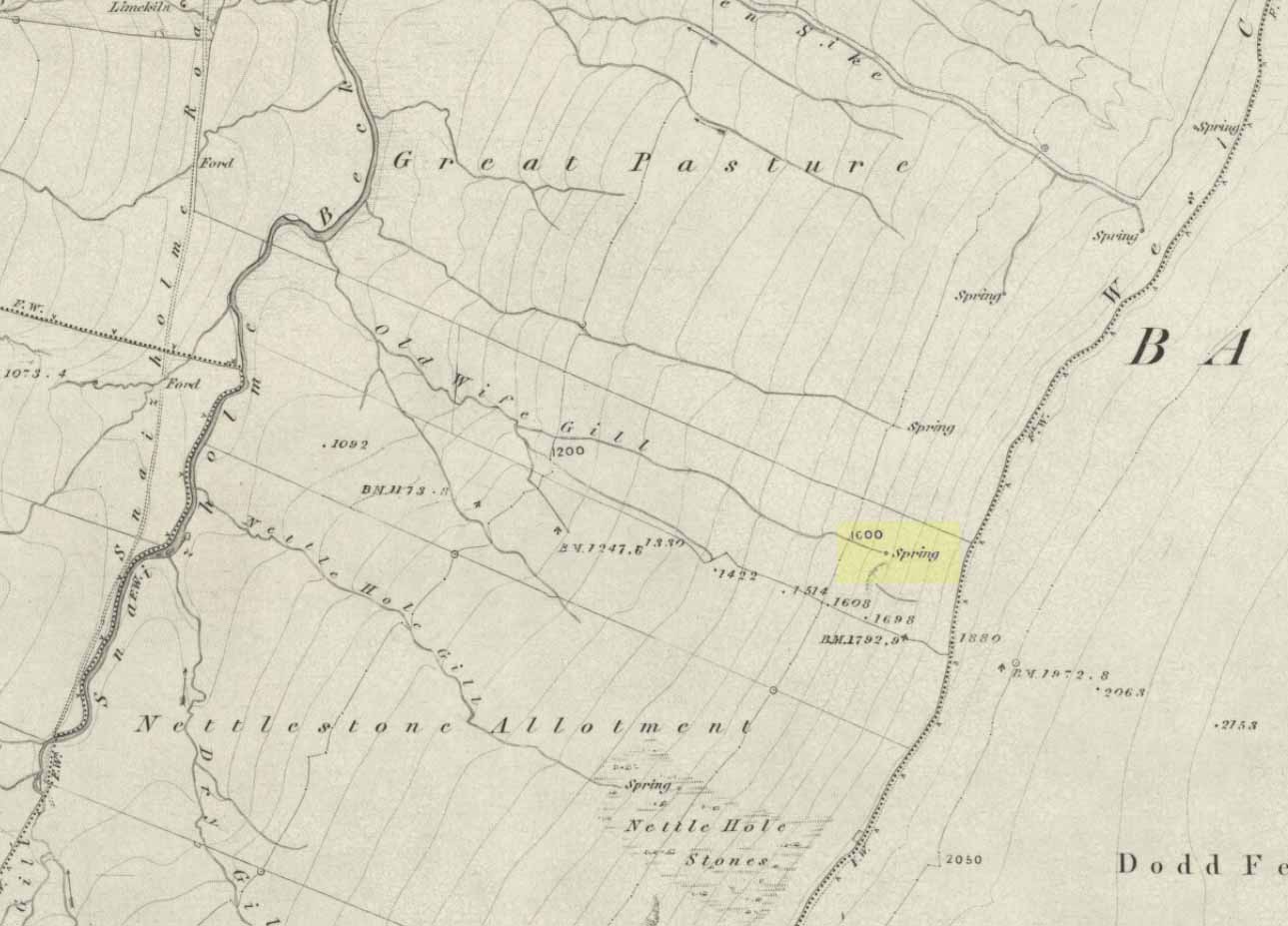
The ‘Spring’ atop of Old Wifes Gill, on 1853 OS-map
From Hawes, take the B6255 road west-ish to Ribblehead, but only for 1km, where there’s the Cam Road track on your left. Walk on here, and keep going till you’re looking down the valley past the very last house (those of you who wanna take the Pennine Way from Hawes will end up in the same place). It’s one of the springs down the steep slope on your right! (check the attached link to the OS-map to work out which one you’re heading for)
Archaeology & History
Apart from a singular mention in place-name records, I have found no historical information (yet!) about this old water supply. It was one of the great sites of the cailleach in our Yorkshire hills: a truly ancient and heathen place, all but forgotten and lost in the mythic landscape of our past. And it’s a bittova dodgy spot getting right up to her down the rather steep hilly slope — but it’s truly well worth the trek!
The Old Wife’s Spring
When I first visited this place, we took off from Cam Fell’s western side and ambled up the tops until the land gave us the beauty of Snaizeholme valley, which had us stopping, dreaming and wanting more as we sought to find this forgotten well. Most of you would probably come from the easier side of Hawes and walk along the path on the southern-side of the valley, or p’raps even wander up Snaizeholme valley itself – but I’d recommend a walk along the tops. Tis much much better!
If you’ve got the 1:25,000-scale OS-map, you’ll see the ‘Old Wife’s Gill’ running down the hillside. Get over the wall by the track-side and stagger down the steep slope. You’ll pass a small spring about 70 yards down – but this aint the one (though I think originally the Old Wife came from much further up Dodd Fell itself). You’ve got another 75 yards to go down before you get to the main spring – but if you’re old and fragile, unfit or fat, you’ll struggle like hell here!
The waters emerge from this very steep slope, surrounded by plenty of thorns and thistles, on a part of the hill where the land itself is slowly coming away. After a long dry-spell no doubt, this might be a little more secure; but when we came here She’d been raining on-and-off like hell and the waters were a-plenty. It’s difficult to actually locate the exact spot where the water first appears – but like I said, it seems to have, long ago, come from much further up the hill. As the photos show, the water’s nice n’ clear, good-tasting, and then continues along its downward stream – known as the Old Wife’s Gill – until hitting the small river at the valley bottom.
The Old Wife’s Spring from below
The other site in this valley which assures us of the cailleach’s validity comes from the place-name a few hundred yards further up the valley, seemingly giving source to the valley river herself: a Lady Spring or well, whose form once emerged close to the gate of the Cold Well close by. The third part of the cailleach’s form – the maiden or virginal – has been lost as far as local myth and literary records go. But I’ve gotta come here a few more times to get an idea as to where this ‘lost’ water-source originally appeared. A number of streams run off the hills here into the curiously-named Snaizeholme valley (which etymologists assign to nowt more than a “place where twigs are” – which seems nonsensical), and as there’s been very little by way of human habitation screwing the land up, there’s a damn good chance we’ll find and recover the mythic history of the landscape here after a few more treks and dreams…
Other sites of similar mythic relevance which need checking include Carlow Hill (SD 770 858)at Stonehouse, Dentdale; and the great valley of Carlin Gill on the North Yorkshire/Cumbria border (SD 634 993 – Gambles 1995:39).
From Otley go north straight over the river and upwards into the countryside for nearly two miles (past the TV mast on the right). As you reach near the top of the hill, there’s a turn to your right. Go on here for a hundred yards or so, then walk along the footpath to your right. After a few hundred yards, keep your eyes out for the stone just through the gate, in the walling on your left.
Archaeology & History
Although we see named on the 1853 Ordnance Survey map the respective place-names of Bride Cross House and Bride Cross Allotment, the first literary reference to any site here as a standing stone appears to be Eric Cowling (1946) who, when commenting on the pagan tradition and folklore of ancient sites, told that
“The name of Bride Cross Farm, Dob Park, is very significant, for at the meeting place of several tracks to the south-east is a squat standing stone built into a wall and marked as a boundary stone, which was probably Brides Cross.”
Bride Stone, Farnley MoorBoundary markers on top
Although I’d read about this place as a kid, it was Graeme Chappell who first brought me here some twenty years back, in one of our many exploratory forays into the prehistory of this area. It’s a nice fat squat standing stone, similar in stature to the more famous Bull Stone near Otley Chevin, a few miles to the south — though our Bride Stone here is about half as high. Only about three-feet tall, it stands by the gate at the wall-side about 200 yards down the footpath from the Dob Park Lodge road and does seems to have been used as a boundary marker, as the letters “F.F.” are carved deeply on top of the upright (possibly denoting the Fawkes family of Farnley).
Cowling’s assertion that this old stone accounts for the ‘Bride Cross’ place-name is probably right, as the site is roughly midway between the respective place-names of the House and Allotment. There is an old field-name of Crosse Close in the vicinity, from 1692, but I haven’t located it. If such a cross ever existed nearby (most likely, it’s gotta be said), it’s obviously the relic which left the place-names — though the standing stone was certainly here first! As yet, we’ve found no references to this place before 1853…which can’t be right…
Folklore
Seems to be a petrification legend in here somewhere. Although the short tale doesn’t say as much, it is supposed to have got its name through “the murder of a bride, rejected by a suitor, on her return from a wedding.” Indeed, I’d go so far as to say ‘fertility’ as well!
Eric Cowling (1946) really stuck his neck out and reckoned sacrifices occurred here in the not too distant past. This may relate to the nearby Haddock Stones, a few hundred yards south, thought to derive its name from a cairn and ‘altar stones.’
References:
Bennett, Paul, The Old Stones of Elmet, Capall Bann: Milverton 2001.
Cowling, E.T., Rombald’s Way, William Walker: Otley 1946.
Phillips, Guy Ragland, Brigantia — A Mysteriography, RKP: London 1976.
Smith, A.H., The Place-Names of the West Riding of Yorkshire – volume 5, Cambridge University Press 1961.


")