If you’re coming up to Oxenhope from Keighley, up the A6033 road, when you reach the school on the right-hand side of the road, a one-way street (Cross Lane) is where you need to walk down, for 200 yards, and keep your eyes peeled in the walling just before Cross Farm Court. Alternatively, via Haworth, go along Marsh Lane for a few hundred yards until your reach Moorhouse Lane on your left. Go down here for ⅓-mile (0.5km) and then go up Cross Lane on your right. About 120 yards up, in the walling just past the entrance into Cross Farm Court is where you’ll find it.
Archaeology & History
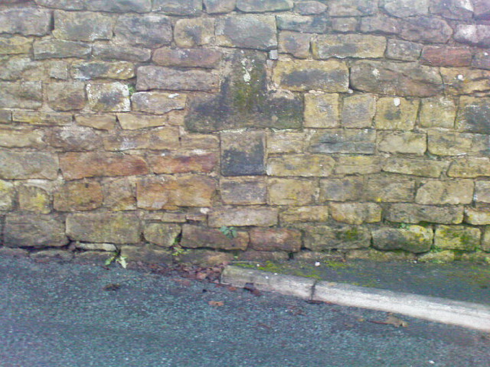
Very little seems to be known about the remains of this cross, embedded into the old walling. When it was described by Brigg & Villy (1914), they could find no information about it, and surmised that it marked the original track or road to Oxenhope from both Haworth and Halifax, “on the line of the old road by Withens.” Ostensibly it would seem to have been a wayside cross, marking old trackways (ley hunters take note!).
Visitors looking at it today can see that it’s barely noticeable. It looked no different even in Brigg & Villy’s days. It simply consists of only part of the original head of the cross, “the shaft having been broken off flush with the horizontal limb.” Some of the other stones that make up the bottom of this very poor-looking excuse of a cross were probably not part of the original, but were assembled into the wall to at least leave of memory of what it used to look like. It’s in a sorry state to be honest. A historic plaque should be placed here.
References:
Brigg, J.J. & Villy, F., “Three Ancient Crosses near Keighley,” in Bradford Antiquary, New Series 6, 1921.
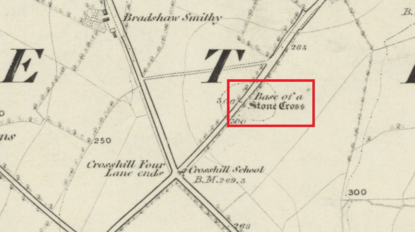
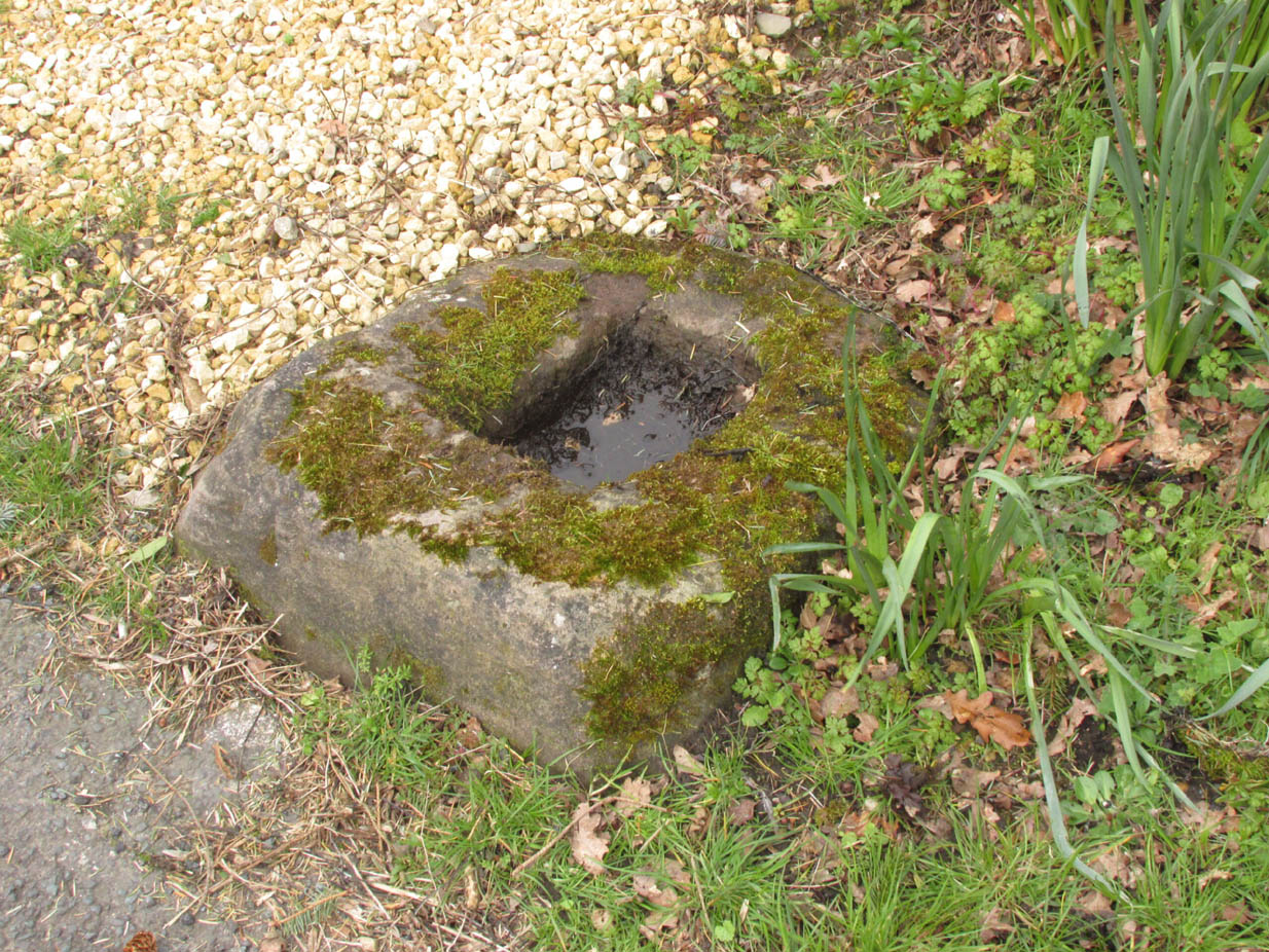
Follow Long Lane northwards from Scorton, over the crossroads at Crosshill Four Lane Ends, and the cross base will be found at the road edge immediately to the right of the driveway of ‘Sandalwood’ on the left hand side of the road.
Archaeology & History
Described in the Historic Buildings listing citation as:
“Cross base, probably mediaeval. A sandstone boulder, roughly rectangular, with rectangular socket.”
Cross base at the roadside‘A sandstone boulder, roughly rectangular’
The base of one of the numerous mediaeval wayside crosses that once adorned this part of Lancashire. So what happened to the cross? It’s possible that it was wilfully destroyed in the early nineteenth century as we have a likely culprit in the person of the Reverend Richard ‘Cross Smasher’ Wilkinson (c.1791 – 1823), Curate of Whitechapel, who took it upon himself to destroy the symbol of his religion wheresoever he could find it.
Immediately to the north west of the Cross is Cross Hill. The cross itself was probably a waymarker on the road over Harrisend Fell from Oakenclough, and Bradshaw may be the name of the locality, there being a Bradshaw Bridge just outside Street to the north west, while the 1846 6-inch OS map records a ‘Bradshaw Smithy’ on the same road.
One helluva climb to reach this little fella. I simply started at Dalgirdy cottage, some 5 miles along Glen Lochay, on the right-hand side of the road. Then, walk right up the burnside, all the way up until it begins to level out and the old shielings appear. When you’ve got to where they just about finish, about 50-70 yards on the east side of the burn, you’ll see the small stone standing upright, all alone. You can’t really miss it!
Archaeology & History
Allt Ghaordaidh, looking south-ish!
No previous written records exist that describe this small standing stone, whose nature and age may be akin to that at nearby Tirai, found amidst the derelict village a couple of miles east, lower down the slopes — i.e., it may have simply been part of some of the ancient village remains and shielings found close by, either side of the rushing burn. But whether it’s only medieval or much more ancient than that, its position in the landscape alone (much like Tirai’s uprights), deserves to be known about.
There are considerable amounts of ancient remains scattering the mountains slopes all round here: some have been catalogued, but a lot of it has not. This little standing stone is at last alive again! (take good food and kit when visiting here)
Although this great and legendary cathedral is today a christian centre, it seems that the site had been deemed as sacred by a much earlier, indigenous culture — though on a scale much more humbling than the grand edifice we see standing here today! For in the northwest corner of the church grounds in 1928, a small burial cist was located. Years later, on October 2, 1975, following work here by the North of Scotland Hydro-electric Board to uncover the main supply “in an area adjacent to the north wall of the Lady Chapel,” they found a slab of stone which, when they lifted it up, covered what appeared to be a burial cist. Messrs Gordon & Gourlay (1976) narrated:
“The stone slab which the workmen had removed proved to be the western section of a larger slab which at some period had been fractured and the eastern section lost. As the interior of the cist was filled with soil similar to that surrounding it and containing a considerable quantity of dispersed human bone fragments, it was suggested that the eastern section of the covering slab had been lost when the drainage and/or electricity services were being installed. The upper surface of the slabs western section was c.35cms below ground surface. The dispersed bones in the cist were at first considered intrusive — possibly from old burials when the public services were installed — and an undisturbed deposition of bones at the base of the cist seemed to confirm this. However, an examination of the bones by Dr A. Young…and Dr D. Lunt…showed that the deposit contained remains of two adults and one child and that many of the dispersed bones could be matched with those in the undisturbed group. In fact, the deposition suggested a re-use of the cist.
“The cist measured internally 1.20m by 0.44m by 0.28m. It lay 8.4m east of the door of the Lady Chapel and 1.44m from the wall of the same. The cist was constructed from ten irregularly-shaped sandstone slabs, with one fractured slab forming the floor. On the south side, two smaller slabs had been placed on the inside of the wall to support the covering slab which only just fitted the cist, and to give extra strength to the wall since they overlapped the vertical joins of the three slabs of the south wall. The north wall slanted to meet the west-end slab 12cm from its edge, giving the cist a coffin-like appearance. The north wall was still vertical; the narrowing was probably intentional as the covering slab was only 33cm wide at that point and the bones lay apparently undisturbed, parallel to the north and south walls. It proved impossible to examine the old ground surface because of the public installations, but it did appear that the ground sloped to the west as the cist certainly did.”
Although the remains found here were not dated, it was initially thought that the cist may have been made around the period when the Lady Chapel was erected around 1250 AD.
“However, Mr J. Stevenson of the Royal Commission for Ancient and Historical Monuments pointed out that the dimensions and construction of the cist accord well with cists of known prehistoric dates in the area; the cist (therefore) would seem to be placed early in the sequences of cist development, assuming it to be prehistoric.”
References:
Cockburn, James H., The Celtic Church in Dunblane, Society of Friends of Dunblane Cathedral: Dunblane 1954.
Gordon, Alistair R. & Gourlay, Robert B., “A Cist Burial, Dunblane Cathedral, Perthshire,” in Glasgow Archaeological Society Bulletin, No.2, 1976.
This old cross was demolished long since, but I think it’s important to rejunevate a memory of its existence back into our times. Little has been written about the site as it was destroyed more than 200 years ago and images of the edifice are rare indeed! It was found near the modern centre of the city and although this ornate-looking thirty-foot tall cross was obviously impressive, an even earlier upright stone stood here in the 13th and 14th century. But this new carved monument took precedence over its older and lesser upright. First described — I think! — by Thomas Gent (1730), he told us that,
“The old cross stood towards the Kennel, against the middle of the market. The lower part was an octagon, had an ascent of six high steps, covered with Tyles for Butchers, higher up with nitches, in which had been effigies and a small pillar above with four Dials and over them a Fane.”
A few years later when Francis Drake (1788) described the same monument, he added very few extra details; though told us it had five steps and not six — but this seems to have been an error on his behalf. In C.B. Knight’s (1944) work we have what seems to be the most complete historical description of this lost stone edifice. He wrote:
“In 1429 a new stone cross had been erected in Thursday Market in place of its predecessor by Marion Braythwayt, widow of John Braythwayt, who was Lord Mayor in 1394… This Cross was described by a writer in 1683 as “a fair Cross of stone, built upon the ascent of five steps, and hath neatly cut in stone a turret or battlement eight square, upon which is placed a round pillar with a four-square stone upon the top, which hath a sundial placed upon every square, and a vane above. The Cross hath a penthouse round about it, covered over with tile, to shelter the market people in rainy weather, and is supported upon eight posts, upon one of which, on the south side, is fixed an iron yard-wand, the standard measure of the market.” In 1705 the ancient Market Cross…was pulled down.”
References:
Cobb, Gerald, “Note on a Drawing of Thursday Market Cross, York,” in The Antiquaries Journal, 43:1, 1963.
Davies, Robert, Walks about the City of York, Nichols & Sons: Westminster 1880.
Drake, Francis, Eboracum; or the History and Antiquities of the City of York, Wilson & Spence: York 1788.
Gent, Thomas, The Antient and Modern History of the Famous City of York, Thomas Hammond: York 1730.
Knight, Charles Bruton, A History of the City of York, Herald: York & London 1944.
The same directions as for the Eastwoods Farm Cup: from Summerbridge, go west on the B6541 towards Dacre Banks, where there’s the signpost for the Nidderdale Way footpath. Follow this past the disused quarry and into the meadows. When you hit the Monk Ing road, bear right (north) and keep going till you’re 100 yards from Eastwoods Farm. Go right, down into the field for about 30 yards or so. Look around!
Archaeology & History
Described in Boughey & Vickerman’s (2003) survey as a “low, medium-sized, quadrant-shaped rock standing up from surroundings, with hollowed out central area.” This hollowed-out central area is, in all likelihood, the remains of a previously unrecognized old cross-base, although investigating archaeologists have somehow missed this. The stone’s proximity to the old Monk’s Way — a medieval trade route used by the local monastic Order — would give added weight to this assertion. A perusal of field-name records here may prove fruitful.
Our authors counted “eight possible small, badly worn cups, (with) three grooves running from central basin, all possibly natural.” The grooves may well be natural, but I’d say that one or two of the cups appear to be genuine. The large hollow in the middle of the stone may originally have been a cup-marking (or maybe even a cup-and-ring — but we’ll never know), before it became used as a site to erect a primitive cross.
Several other cup-and-ring carvings can be found around here — the Eastwoods Farm Cup is in the same field nearby— with the great likelihood of there being others hidden amidst trees or grasses, waiting to be re-awakened! The hugely impressive Morphing Stone and a prehistoric lightning-carving can be found in the next field, full of rocks, on the other side of the stream.
References:
Boughey, Keith & Vickerman, E.A., Prehistoric Rock Art of the West Riding, West Yorkshire Archaeology Service 2003.
Whether coming from Hebden Bridge or Oxenhope: at the very top of the long uphill road, at the very top where a small radio station sits by the roadside (the views from here are effing superb!) – stop! On the opposite side of the road from the radio station, get over the fence (I think there’s a gate nearby) and walk roughly westwards down the gently inclining grassland slope. Keep westward-ish for about 200 yards (if that) and you’re damn close!
Archaeology & History
Rediscovered in January 2002, this is a very curious stone, over a metre in height, isolated on the southern edge of Roms Hill, close to the folklore-sounding Halfpenny Hole Clough, near the very top of the hill between Hebden Bridge and Oxenhope. The base of the stone is almost wedged into a space between two rocks and its positioning here seems quite deliberate. It stands upon a small geological ridge in the ground that stretches for some distance, east and west, either side of here.
Roms Hill Stone in good fog!
Despite this, it seems unlikely to have an authentic prehistoric pedigree, but as there’s little else been said of the stone (apart from Dave Shepherd’s (2003) article on local megalithic remains, many of which are highly dubious as archaeological remains), it deserves a mention here. It’s not recorded in any of the old boundary records — unlike the upright boundary stone that can be found a few hundred yards northwest of here on the same moorland plain.
The land here has an etymological relationship with the Roms Law (or Grubstones) Circle on Rombald’s Moor, but as yet we can ascertain little more about this site. Well worth a visit — if only for the superb views it affords!
References:
Shepherd, David, “Prehistoric Activity in the Central Pennines,” in Transactions of the Halifax Antiquarian Society, volume 11 New Series, 2003.
From Keighley town centre, take the main road to Oakworth (B6143) and you’ll see it right by the main roadside, about a mile up on the left-hand side upon a small grassy area in Exley Head, just past the turning up to Wheathead.
Archaeology & History
The upright stone monolith, or cross, which would once have stood here has long since disappeared. All we are left with today is the large cross-base by the roadside: roughly squared, with a large hollow at the centre in which the upright stone cross originally stood erect! In the past, a number of archaeologists and historians have speculated that the Exley Head Cross dated from as early as the 9th up till the 15th century. We may never find out for certain, though it’s likely a post-Domesday medieval relic. It’s position at the roadside gives it the category of being a ‘Wayside Cross’ and it is likely one in a deliberate sequence that were placed along the ancient route from above Keighley, to Oakworth and over the border into Lancashire, near Wycoller and beyond.
Close-up of Exley Head Cross base
Quite why it was placed here is something we may never know: though it is close by an old crossroads and could have replaced an earlier heathen site, but I’ve found no records to indicate this. Its position in the landscape would also have been more impressive before the housing was here, previously giving a wide open view of the Aire Valley below. I’d be grateful for any more info on this site.
References:
Brigg, J.J. & Villy, F., “Three Ancient Crosses near Keighley,” in Bradford Antiquary, New Series 6, 1921.
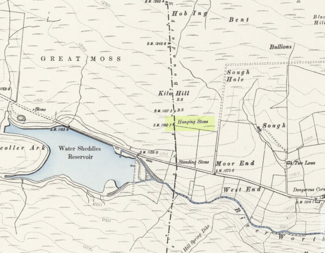
Pretty easy to find. Go along the Oakworth-Wycoller road, between Keighley and Colne, high up on the moors. When you get to the Water Sheddles Reservoir right by the roadside (y’ can’t miss it), stop! On the other side of the road walk onto the moor, heading for the walling a coupla hundred yards to your east (right). Where the corner edge of the walling ends, your standing stone is right in front of you! If for some reason you can’t see it, wander about – though beware the very boggy ground all round here.
Archaeology & History
This seven-foot tall monolith, leaning to one side thanks to the regularly water-logged peat beneath its feet, stands on the Yorkshire-Lancashire. It is locally known as the Hanging Stone and the Standing Stone, but the name ‘Water Sheddles’ is a bittova puzzle. The place-names authority, A.H. Smith (1961) thinks it may derive from the middle-english word, shadel, being a ‘parting of the waters’ – which is pretty good in terms of its position in the landscape and the boggy situation around it. But ‘sheddle’ was also a well-used local dialect word, though it had several meanings and it’s difficult to say whether any of them would apply to this old stone. Invariably relating to pedlars, swindling or dodgy dealings, it was also used to mean a singer, or someone who rang bells, or a schedule, aswell as to shuffle when walking. Perhaps one or more of these meanings tells of events that might have secretly have been done here by local people, but no records say as such — so for the time being I’ll stick with Mr Smith’s interpretation of the word! Up until the year 1618 it was known simply as just a ‘standing stone’, when it seems that the words “Hanging Stone or Water Sheddles Cross” were thereafter carved on its west-face, as the photo below shows.
Cross carved on top of the stoneThe old stone, with its names carved for all to see
Whether or not this stone is prehistoric has been open to conjecture from various quarter over the years. Is it not just an old boundary stone, erected in early medieval times? Or perhaps a primitive christian relic? Certainly the stone was referred to as “le Waterschedles crosse”, as well as “crucem”, in an early record describing the boundaries of the parish of Whalley, dating from around the 15th century. This has led some historians to think that the monolith we see today is simply a primitive cross. However, sticking crosses on moortops or along old boundaries tended to be a policy which the Church adopted as a means to ‘convert’ or christianize the more ancient heathen sites. It seems probable in this case that an old wooden cross represented the ‘crucem‘ which the monks described in the early Whalley parish records.
Site marked on 1892 map
This monolith likely predates any christian relic that might once have stood nearby; although the carving of a ‘cross’ on the head of the stone may have supplemented the loss of the earlier wooden one. But it seems likely that this carved ‘cross’ was done at a later date than the description of the ‘crucem‘ in the parish records — probably a couple of centuries later, when a boundary dispute was opened, in 1614, about a query on the precise whereabouts of the Yorkshire-Lancashire boundary. After several years, as John Thornhill (1989) wrote,
“the matter was resolved on the grounds that the vast Lancastrian parish of Whalley had claimed territorial jurisdiction as far east as the Hanging Stone, thus the county boundary was fixed on the Watersheddles Cross.”
Water Sheddles stone looking SW
Certainly the stone hasn’t changed in the last hundred years, as we can tell from a description of it by Henry Taylor (1906), who said:
“The remains consist of a rough block of stone, leaning at an angle of about forty-five degrees against a projecting rock. The top end has been shaped into the form of an octagon, on the face of which a raised cross is to be seen. The stone is about six feet long and two feet wide, tapering to eleven inches square at the upper end, and appears once to have stood upright. Some local authorities have cut on it the words, ‘Hanging Stone or Waterscheddles Cross.'”
So is it an authentic prehistoric standing stone? Tis hard to say for certain I’m afraid. It seems probable – but perhaps no more probable than the smaller Great Moss Standing Stone found just a couple of hundred yards away in the heather to the west, on the Lancashire side of the boundary. Tis a lovely bitta moorland though, with a host of lost folktales and forgotten archaeologies…
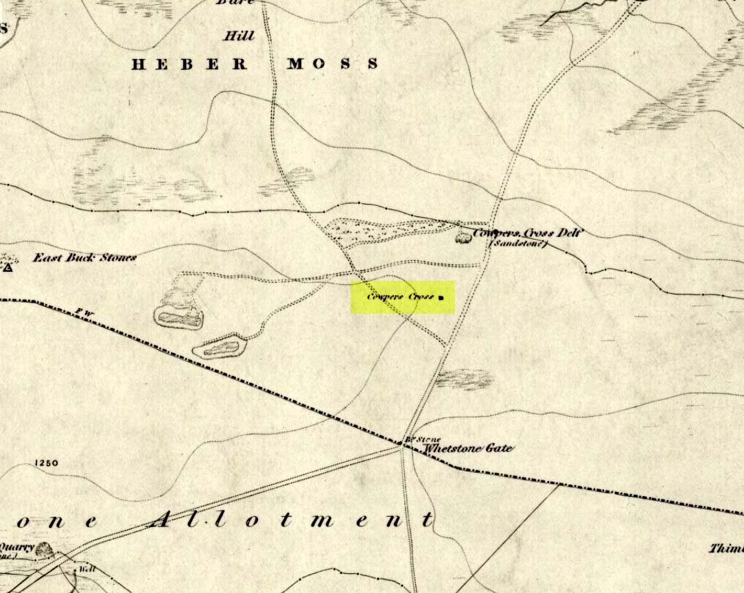
From Ilkley town, head up the road as if you’re going to White Wells but keep following the moorland road up towards Whetstone Gate and the TV masts on the very tops (you’ll have to walk the last half-mile). Shortly before you get them, you can’t miss this relic by the track-side on your right-hand side.
Archaeology & History
Possibly a christianised monolith, erected here in an attempt to divert local people away from the impressive Badger Stone where they may have held springtime gatherings. There used to be an old monolith laid on the ground a few yards away from the cross, which may have stood upright before the cross was erected. Also on the south-facing side of the cross were four cup-markings, indicating great age. These may also have been added when the cross was erected. (We know this occurred at other sites in the region, e.g., Churn Milk Joan, Midgley Moor, where such cup-marks were added sometime in the 15th or 16th century.) However, thanks to some idiotic halfwits in more recent years going up here and vandalizing Cowper’s Cross, the prehistoric cup-markings that were on this relic have been destroyed. The upright shaft of the cross that’s here now is a re-worked gatepost that replaced the old shaft with its authentic ‘pagan’ carvings.
1920s postcard of the Cross
But it’s had other bits of bad luck through the years. The site was struck by lightning many years back, splitting the stone in half, but has since been rebuilt and stands adjacent to its original position, right next to the old Roman road that crosses Ilkley Moor. Historian Allan Butterfield suggested this site to have originally been an old boundary markstone, christianised many centuries ago. The name ‘Cowper’ derives from the local Ilkley family of Cawper.
Those of you interested in the early christian history of these moors should also have a look at the little-known Black Knoll Cross, less than a mile south of here in the middle of Morton Moor.
Folklore
Folklore relates that markets were held at this old stone cross many years ago. This gives added weight to the idea that the nearby cup-and-ring marked Badger Stone, where markets were probably held around the time of the equinoxes, was the original site for such gatherings. Note that another site, the Reva Hill Cross, on the eastern side of this moor, has much the same history.
References:
Bennett, Paul, The Old Stones of Elmet, Capall Bann: Chieveley 2001.
Cowling, E.T., Rombald’s Way, William Walker: Otley 1946.