Healing Well (destroyed): OS Grid-Reference – NT 2547 7337
Archaeology & History
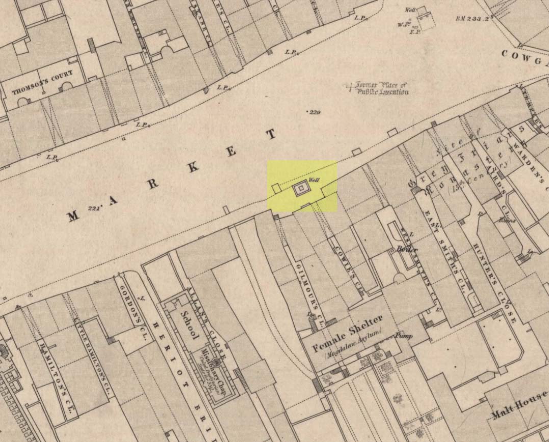
Muses ‘Well’ on 1852 map
We have the historical detective work of Stuart Harris (1996) to thank for the location and probable meaning behind the name of this long-lost well, that could once be seen along Haymarket, near the heart of the old city. Shown on the 1852 OS map, without name, the site was recorded as a public well “from 1502 onwards,” he wrote — and its name was variably written as muse, muss, meus and mwse, which led him to surmise that it was from the old Scots word “meuse”, or the “well by the stables”; although I cannot find this validated in the established dialect dictionaries and glossaries of William Grant (1934-76) or Simon Taylor (2012). Their relative definitions tell it to be of a mouse, or a small trackway left by rabbits, hares or rodents, running between hedgeways. This would mean the ‘Muse Well’ was a variant around a “well by an animal track”, which in earlier centuries were very important to note, as wild animals were indicators of food (amongst other things).
This aside, “the King’s Stables, dating from the 1340s, were of course over 200 yards further west,” he wrote,
“but the convent of the Greyfriars, founded in 1471 in the Cowgatehead only about fifty yards east of the Muse Well, certainly gave lodging to travellers of the more distinguished sort, and although no early record of stables here has come to light, it may be no accident that the only stables recorded in the Valuation Roll of 1635 as being on the south side of Grassmarket were in McIntyre’s Close, which had its entry ten yards east of the Well.”
References:
Grant, William (ed.), The Scottish National Dictionary – 10 volumes, SNDA: Edinburgh 1934-76.
Harris, Stuart, The Place-Names of Edinburgh: Their Origins and History, Gordon Wright: Edinburgh 1996.
Taylor, Simon & Gilbert, Markus, “Elements Glossary”, in The Place-Names of Fife – volume 5, Shaun Tyas: Donington 2012.
Standing Stone (destroyed): OS Grid Reference – NO 483 603(approximation)
Archaeology & History
In an area once teeming with megaliths, this is but one that lost its life in the 19th century. It would seem that the only reference of its existence—and demise—comes from the pen of the great regional historian Andrew Jervise (1853) who, in a description of the nearby holy well of St Ninian, in a field near Wellford,
“within the last half century there were two or three large rude boulders nearby, which were called Druidical stones.”
References:
Jervise, Andrew, The History and Traditions of the Land of the Lindsays in Angus and Mearns, Sutherland & Knox: Edinburgh 1853.
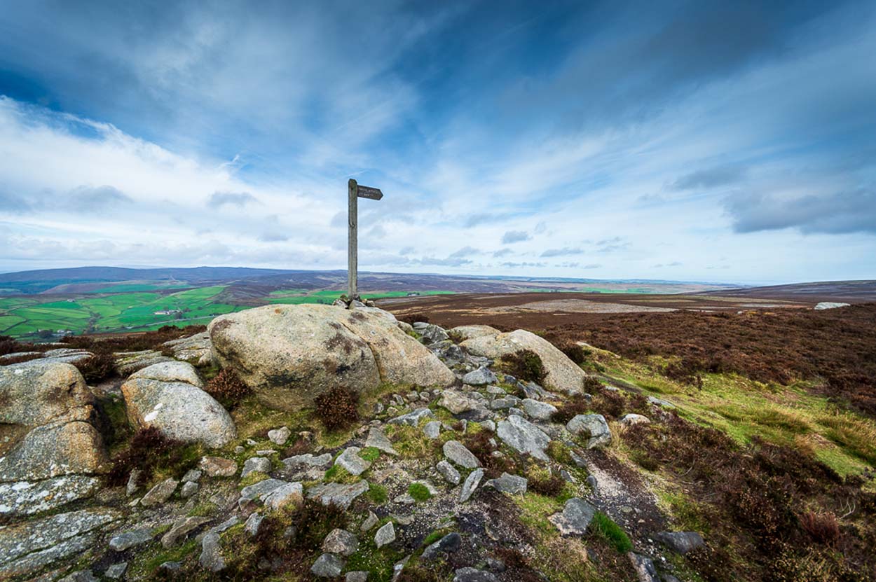
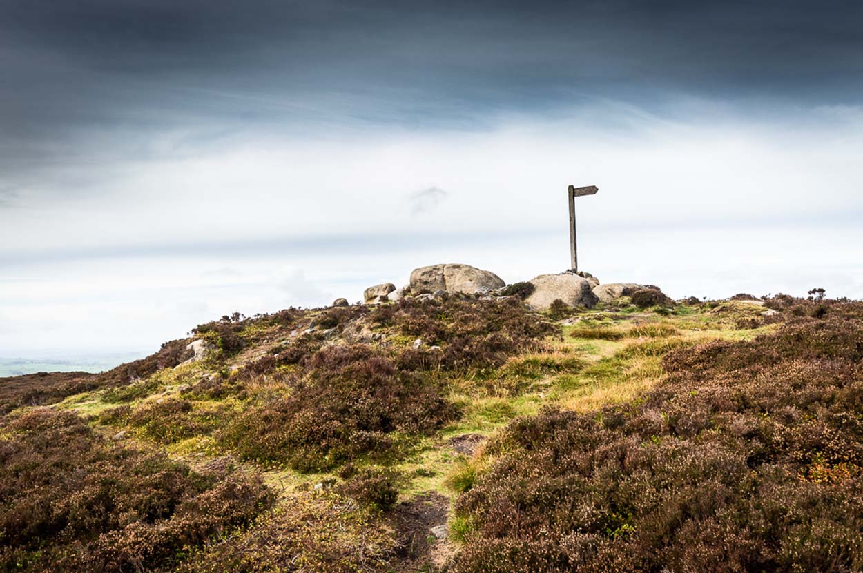
If you’re coming via Ilkley, cross the bridge to Middleton and turn left, following the long winding road for several miles until you hit Langbar village. If you’re coming via Bolton Bridge, go to Beamsley village and turn left up Lanshaw Bank until you hit Langbar village. Whichever of the two routes you use: on the north side of Langabr village is a distinct small rough car park. From here, cross the road where the footpath sign is and walk straight up the steep hill to Beamsley Beacon at the top. You can’t miss it!
Archaeology & History
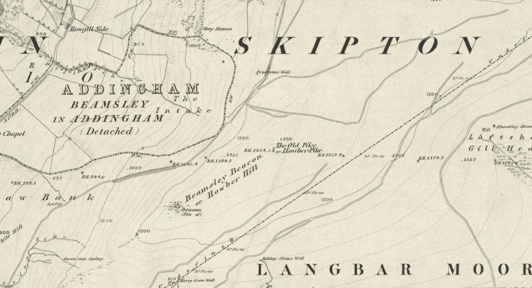
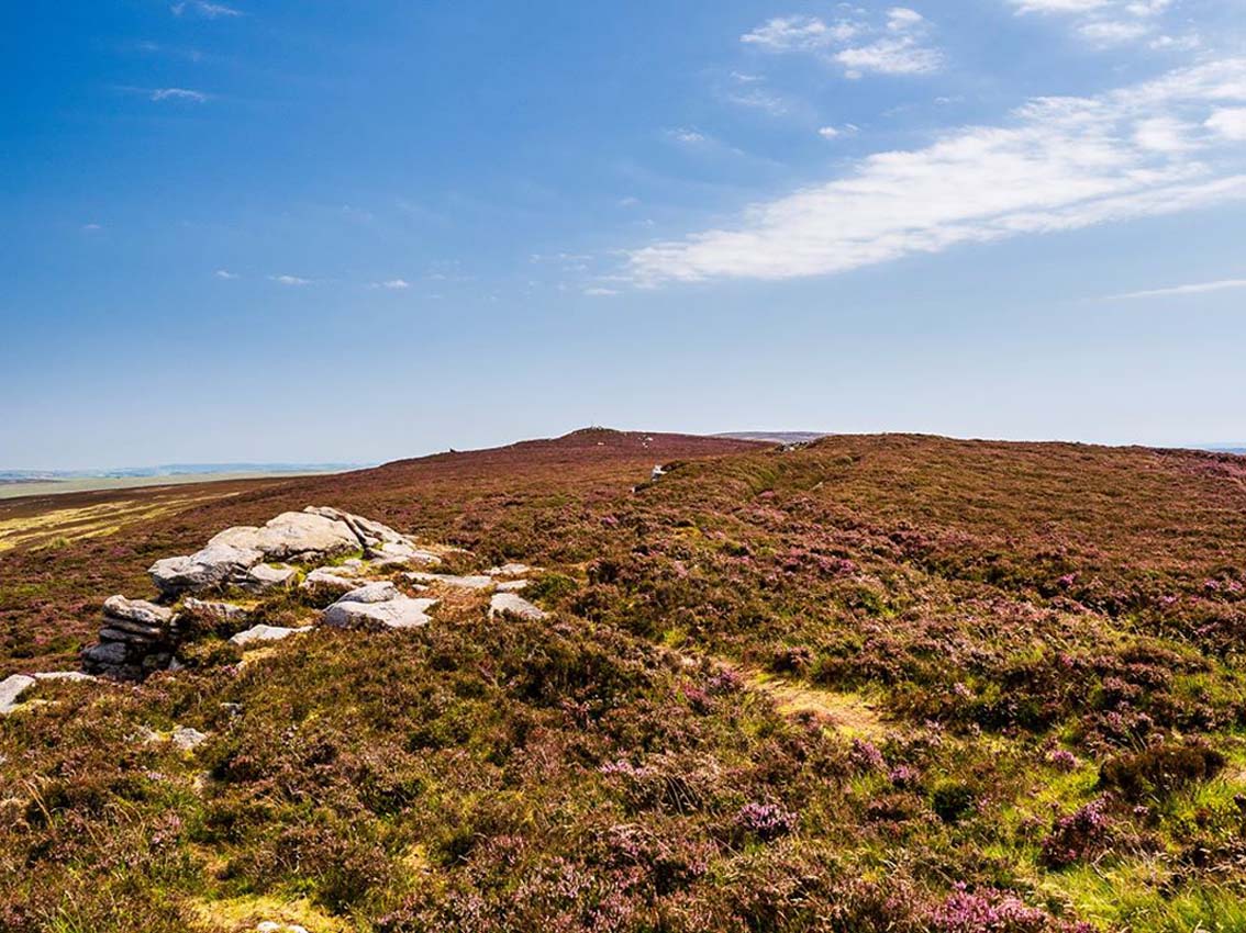
At the highest point on these hills, 1300 feet up, we come across this ancient prehistoric cairn. Its position in the landscape is impressive to say the least, being visible from nearly every direction on the moorland heights for many miles around, as well as being conspicuous from the riverlands below. A visit to the site nowadays shows it surmounted by a more recent mass of small stones turning it into a large walker’s cairn with only its compact base showing any real sign of antiquity.
Site shown on 1853 mapWestern side of the cairn
Mentioned briefly in parish records from 1658 onwards, it was highlighted on the earliest OS-map as simply a Beacon hill, due to it being used for beacon fires. We’re not certain when its beaconesque function first came about; and, it’s possible, that its beacon element could have replaced a much earlier heathen fiery function, typical of many hilltop sites up and down this and other countries. But we do know that such fires were lit here at the beginning of the 19th century. The great Harry Speight (1900) told that of its
“use as a prospecting-point and beacon there is no doubt. In the Bolton Abbey registers, under date 1803, is this entry:
“Apprehensive of a French invasion, Beamsley Beacon was put in a state of repair, and four people appointed to watch it. About — of the inhabitants of this chapelry inrolled themselves as Volunteers, the whole number of whom in Craven amounted to 1,200 Infantry and 200 Cavalry. A Sergeant was appointed to drill the volunteers of this chapelry at Bolton.”
The beacon at this time received light from Pinhaw on Carlton Moor and sent it forward to Otley Chevin, as appears by an old chart at Wakefield, dated 1803.”
The beacon’s ancient name of Howber Hill is literally the Hill of Tombs, as derived from the Teutonic haugr, and Anglian how, being a burial mound; and berg is a hill, sometimes fortified. Whilst there seems to be no evidence of ancient fortification, compacted cairn material at the base seems to confirms the -how element. Yet despite Speight citing this etymology, he was was somewhat sceptical wondering, instead, if the site was merely a giant boundary marker—which it has been for centuries.
A short distance along the footpath to the east is the denuded old cairn known as The Old Pike. Further east still, along the same boundary line, there was once another old tomb, long since gone…
Folklore
I’m not sure whether this should gone in the folklore section or not. But, well, it’s here nonetheless! In Guy Phillips’s (1976) book on the mythic history of ancient Brigantia, he describes a number of alignments, or leys (not one of those stupid energy lines, which has nowt to do with leys)—one of which crosses Beamsley Beacon. It’s an west-east line that begins at Cockerham and from there goes,
“through Top of Blaze Moss SD 619525, Slaidburn (it is very clear here), Flambers Hill SD 877523, southern edge of Copy Hill 952523, Draughton (extremely clear), Beamsley Gibbeter and Beamsley Beacon, Heligar Pike, Scow Hall 203523, Little Almscliffe Crag, Tockwith church and on to the coast.”
I have to say that I’m sceptical of the veracity of this alignment.
References:
Bogg, Edmund, Higher Wharfeland, James Miles: Leeds 1904.
Cobley, Fred, On Foot through Wharfedale, William Walker: Otley 1880.
Phillips, Guy Ragland, Brigantia – A Mysteriography, RKP: London 1976.
Smith, A.H., English Place-Name Elements – volume 1, Cambridge University Press 1956.
Smith, A.H., The Place-Names of the West Riding of Yorkshire – volume 5, Cambridge University Press 1963.
Speight, Harry, Upper Wharfedale, Elliott Stock: London 1900.
Acknowledgements: Huge thanks to James Elkington for use of his photo on this site profile. Cheers mate. 😉
Holy Well (destroyed): OS Grid Reference – TA 026 223
Archaeology & History
This curiously-named, lost holy well was to be found somewhere between the old terrace at West Field and the old road of West Acridge, but even when Henry Ball (1856) wrote about it, the site had passed into history. He told that,
“In the old enclosures to the west of the town was a spring of clear water called St. Trunnion’s well, and in a field in the West Acridge a very old thorn tree called St, Trunnion’s tree, which was standing in 1736; but who St. Trunnion was is not known…”
The close proximity of the tree with the well is highly likely. Throughout the British Isles there are many relationships where sacred trees and wells of the same name are next to each other and we have little reason to doubt this was the case here. However, unless local historians can uncover some old field-name maps, the exact location of the site seems to have been lost. It was named as St Tronians in 1665; with his sacred tree mentioned in early enclosure awards dated 1681 and 1697 respectively.
The enigmatic saint ‘Trunnion’ is thought to derive, not from some old hermit or heathen holy dood, but from the corruption of an early word: “a perversion of Trin-union or Tri-union, used as an asservation or oath”; although another option cited by Cameron (1991) is that it derives from “trinune, trin-une, referring to the Trinity”—which would explain the sanctification of the waters.
Cross (destroyed): OS Grid reference – TA 0424 2064
Archaeology & History
This long lost wayside cross was described in various local records from 1621 upwards. In the definitive place-name survey of this area, Kenneth Cameron (1991) told us that this was,
“A medieval cross dedicated to St James, situated at the point where the Thornton and Burnham roads meet… Mr R. Newton comments, “said to have replaced a wayside shrine. The foundations of the shrine were exposed when the Home Guard dug a defensive trench there at the beginning of the last war. Foundations destroyed by a bomb.””
References:
Cameron, Kenneth, The Place-Names of Lincolnshire – volume 2, EPNS: Nottingham 1991.
I prefer the much longer walk to this site, from Askwith Moor carpark some 5 miles to the west, but this wouldn’t be most folks cuppa tea. So for the lazy buggers amongst you: whether you’re coming via Ilkley (cross the bridge to Middleton and turn left, following the long winding road for several miles) or Bolton Bridge (hit Beamsley village and turn left up Lanshaw Bank), you need to get up to Langbar village. On the north side of the village is a distinct small rough carpark. From here, cross the road where the footpath sign is and walk straight up the steep hill to Beamsley Beacon at the top. Keep walking for exactly ¼-mile where you’ll find a large heap with boulders round its edge. You’re there.
At the highest point of these hills where the moorlands of Langbar and Beamsley meet, is this prominent rocky pile on the same skyline as Beamsley Beacon. The two are ancient cairns, both robbed of most of their stones, but still a good site to sit and behold the vast landscape which reaches out for miles in all directions. And, from this highest point, looking south to the highest point across the Wharfe valley on Ilkley Moor, the remnants of another giant prehistoric cairn is visible: looking across at each other, eye to eye.
Of the two great cairns on Beamsley moor, The Old Pike is the more peculiar of the two because—unlike its partner along the ridge—several large boulders near its top give the impression of being Nature’s handiwork. This may be the case, but Nature isn’t the lass who laid down the mass of smaller rounded stones that are mainly visible on the west and southern sides. These have been placed there by people. But it’s not until you step back 40 or 50 yards that you get a more distinct impression of the place. The Old Pike rises up like a rocky nipple out of the heath, showing a very embedded overgrown man-made heap, typical of the overgrown prehistoric cairns that scatter our northern uplands.
The site is included on the archaeologist’s Pastscape website, albeit citing it as a ‘possible’ cairn. But the more we look at it, the greater the impression becomes that this old heap is man-made – certainly on its eastern and southern sides. The rise of boulders on its west may be natural, and then ancient man placed the cairn material up and around them. Only an excavation would tell us for sure. But its old name of Howber Pike tells a tale before we even visit the place. When the great Yorkshire historian Harry Speight (1900) came here he picked up on this element, telling us,
“Howber literally is the ‘Hill of Tombs’, from the Teutonic haugr and Anglian how, a burial mound, and berg also her, a hill, often fortified.”
The great place-name authority A.H. Smith (1956) not only echoes this but goes into greater etymological detail, noting that as well as haugr or how being “an artificial mound, a burial mound,” it’s a word that is particularly used in the northern counties. He does note however, that this may not always be the case and can sometime just relate to a “a hill or hilltop resembling an artificial mound.” However, we also find in Smith’s tome on place-name elements that the latter part of ‘Howber’ deriving from beorg, can also mean a tumulus or burial mound. But there are cases where this has been corrupted and means, as Speight states, a fortified hill. So at Howber Pike we seem to have the ancient name of some probable burial site. As for its neighbour a quarter-mile west, the giant cairn of Beamsley Beacon is also known as the Howber Hill….
References:
Smith, A.H., English Place-Name Elements – volume 1, Cambridge University Press 1956.
Smith, A.H., The Place-Names of the West Riding of Yorkshire – volume 5, Cambridge University Press 1963.
Speight, Harry, Upper Wharfedale, Elliott Stock: London 1900.
Acknowledgements: Huge thanks to James Elkington for use of his fine photos on this site.
Healing Well (destroyed): OS Grid Reference – SE 22 33
Archaeology & History
Ths curiously-named site is described just once in very early field-name records as the ‘Fukewell’. Included in A.H. Smith’s (1961) magnum opus, he passes over the place-name without comment. But in finding his 12th century literary source, we read that it was located on some land given to the monks of Kirkstall Abbey, Leeds. Written in early disjointed Latin, we find that the Fukewell was mentioned on a grant that described five acres of land given by one Adam Samson to the monks of the Abbey. On one of the acres was a site known as the Cold Well, whilst the Fuke Well was found on a piece of land adjacent to a house, but its precise location seems to have been lost. Nothing is mentioned about it by great Pudsey historan Simeon Raynor, despite him naming a number of other wells in the area – so we must presume that the site had already gone when he came to write his work.
But what does the word fuke actually mean? There is nothing to explain it in Wright’s Dialect Dictionary, nor other regional dialect or place-name works. I was wondering if it derived from the old english word ‘fuck’, which was common parlance in earlier centuries. ‘Fucking’ was a word that didn’t have the debased christian ideology attached to it: of something not to be talked about, or be hidden. To have a fuck, or go fucking, was always quite normal; and to most people in the real world we use the same term with absolute ease – because we all do it! But this etymological idea is pure speculation on my part. Can anyone give clear light to fuke’s real meaning?
References:
Fryer, Peter, Mrs Grundy, Dennis Dobson: London 1963.
Lancaster, W.T. & Baildon, W. Paley (eds.), The Coucher Book of the Cistercian Abbey of Kirkstall, Thoresby Society: Leeds 1904.
Smith, A.H., The Place-Names of the West Riding of Yorkshire – volume 3, Cambridge University Press 1961.
Tumulus (destroyed): OS Grid Reference – TQ 288 726
Archaeology & History
This long lost prehistoric tomb is one of many that has fallen under the destructive hammer of the christian Industrialists in this part of the country. Located somewhere in the parkland grounds of Bedfordhill House (also destroyed), its memory was thankfully preserved by the renowned folklorist and historian Walter Johnson (1903) who wrote of it in his work on prehistoric Surrey, where he told:
“A few years ago a supposed barrow was levelled in Bedford Park, Bedford Hill, Tooting, and no record taken of the results. The mound was enclosed in the Park for several centuries, but when the grounds were laid out for building purposes ten or a dozen years since, it suffered rough usage, and was finally destroyed. It was nearly 100 yards long, and about 20 feet in breadth in its highest part. It ran East and West, and had several trees growing on it before its desecration…. A moat had been made round the mound for about two-thirds of its circuit. This moat was supplied with water by the Ritherdon, a small stream rising in Streatham. The name is preserved in the adjacent Ritherdon Road. The material of the mound was gravel and gravelly loam, which, in the neighbourhood, occurred only in a thin layer, thus forbidding the conclusion that the structure was merely composed of the soil dug out in making the moat. The excavated material would largely be London Clay. As the genuineness of this barrow was, we believe, called in question after its demolition, when the subject was beyond reconsideration, we mention two shreds of collateral evidence. The ground on which the tumulus stood was about the highest in the district. The name Tooting may also have some bearing, for Mr. Clinch thinks that it was a Celtic settlement where was worshipped the deity known as Taith. (Compare also toot-hill, as exemplified in Tot Hill, Headley, Tothill Fields, Westminster, famous for fairs and tournaments, also Tutt Hill, near Thetford.)”
The ‘toot’ in Toothill however, is ascribed by Gover, Mawer & Stenton (1934) as being the usual “look-out hill”. Although they do make note of the fact “that there is no hill in Tooting which would make a good look-out place.” But if this was a large barrow of some type, it would explain the etymological oddity. Any further information on this site would be welcome.
References:
Gover, J.E.B., Mawer, A. & Stenton, F.M., The Place-Names of Surrey, Cambridge Univserity Press 1934.
Johnson, Walter, Neolithic Man in North-East Surrey, Elliot Stock: London 1903.
Smith, A.H., English Place-Name Elements – volume 2, Cambridge University Press 1954.
This ancient “bowl barrow” as the modern archaeo’s are wont to describe it, is a Bronze Age tumulus that has seen better days. But at least it’s still there – albeit slightly damaged and enclosed by modern housing, in the back of someone’s garden. I expect that if you were to ask the owners, it would be OK to see this 4000 year old burial mound (in Scotland at least, we always find people very amiable when it comes to asking such things). It’s quite a big thing too, so you can’t really miss it! Standing more than 12 feet high, it rises like an archetypal fairy mound—now out of place—measuring some 38 yards east-west and roughly 44 yards north-south.
Highlighted on the early OS-map of the region, the name of the site indicates its multi-period usage, with the ‘beacon’ element derived from when, in 1594, a fire was lit upon it to tell of the arrival of the Spanish Armada. Whether it had been used as a beacon prior to that, I can find no historical accounts. One of the early archaeological descriptions came from the pen of the old historian and folklorist, Walter Johnson (1903), who told us simply:
Tumble Beacon on 1871 mapWalter Johnson’s 1903 sketch
“About a mile South-west of Banstead Church, in a field close by Tumble Farm, on the outskirts of Nork Park, is an eminence marked on the map as Tumble Beacon. A picturesque clump of pines stands on the mound, which, from its general character, and from the flint scraps we have found there, we have every reason to believe is a round barrow, despite the local tradition that it is a ‘sea-mark.’ The Scotch pines, in such positions as we find here, may probably, Mr. Grant Allen thought, be the descendants of trees put in by human hands when the barrow was first raised.”
Whilst this latter idea might be very hard to prove, the assertion that it’s prehistoric certainly gained favour as more antiquarians examined the site. Johnson later told that when examining this and other sites nearby (sadly destroyed) he came across a variety of prehistoric stone utensils in the area.
References:
Gover, J.E.B., Mawer, A. & Stenton, F.M., The Place-Names of Surrey, Cambridge Univserity Press 1934.
Grinsell, Leslie V., The Ancient Burial Mounds of England, Methuen: London 1936.
Johnson, Walter, Neolithic Man in North-East Surrey, Elliot Stock: London 1903.
Lambert, H.C.M., History of Banstead in Surrey, Oxford University Press 1912.
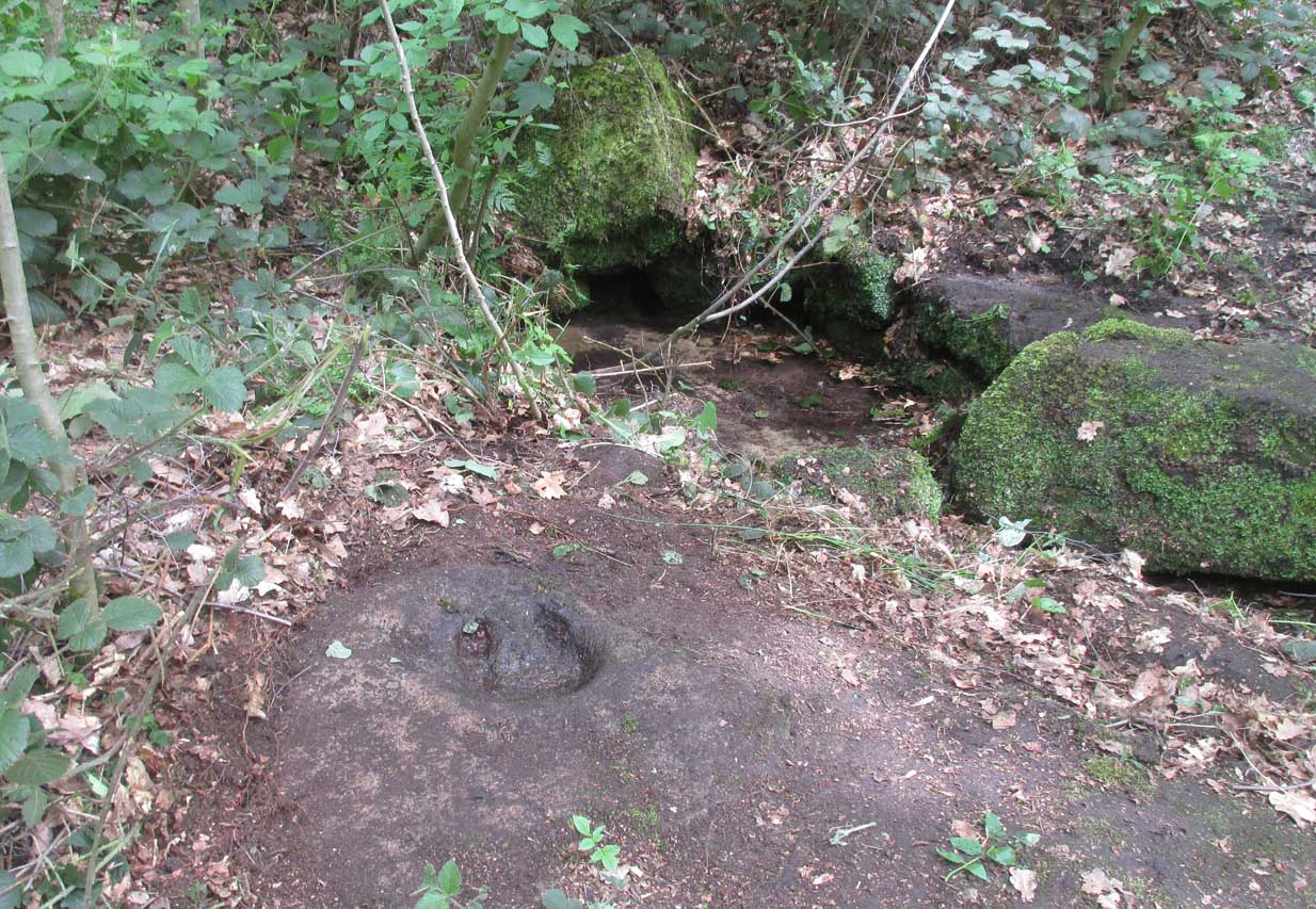
On the roadside at Shipley Glen, from Brackenhall Circlewalk up for about 250 yards, where you’ll notice the land dips as it drops into the woods below. Follow this dried stream down until you reach the mossy Loadpit Beck in the valley. By the waterside is a footpath: follow this upstream for a short distance, keeping your eyes peeled on the Earth below where a smaller stream crosses the path you’re walking on. Follow this uphill to its source!
Archaeology & History
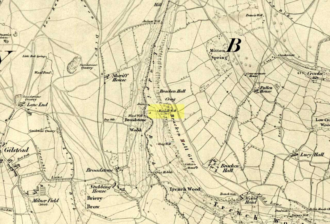
Halfway up (or down) the moss-covered waters of Shipley Glen the all-but-forgotten waters of the Cloven Hoof Well still flows nice and freely, and is still good to drink. It was shown on the first OS-map of the area in 1852, where it was called the Raygate Well, whose derivation neither the great Baildon historian W. Paley Baildon nor the place-name giant A.H. Smith could account for. It sounds just like it was someone’s surname, but local genealogy cannot affirm this. One possibility—and which reflects in the local lore of the site—is that it’s a compound word from the old northern dialect word Rea, “an evil spirit or demon”, and gate, “a hole, an opening or gap.” The terms are used in a prayer given in Mr Sinclair’s Satan’s Invisible World Displayed (1814),
“as recited in the time of Popery by persons when going to bed, as a means of them being preserved from danger:
“Keep this house from the weir… And from an ill Rea, That be the gate can gae.””
But this purely speculative….
Cloven Hoof Well on 1852 map
A photograph and brief description of the Cloven Hoof Well was given in an early edition of the Bradford Scientific Journal after a geological excursion to Shipley, though nothing was said of its curious name. However on a rock below the spring, a hoof-print mark is clearly seen. It appears to be part-natural and partly enhanced. This is an area rich in prehistoric petroglyphs, or cup and rings stones.
Mosses thankfully still cover the rocks from whence the waters flow; and bilberry, blackberry, male fern and bracken also grow around it. Psychoactive plants also abound nearby. The water is healthy and never seems to dry up, even during long warm summers. And below here, on the other side of the stream at the bottom, you can visit the little-known Wood Well.
Folklore
Local lore told that the devil stepped here and left his hoof-mark in the rock, making the waters rise from the Earth. Possibly a venerated site in earlier days, one finds numerous ancient remains nearby (cup and rings, stone circle, walling, cairn fields). Pagans amongst you should love this place!
References:
Armitage, Paul, The Holy Wells and Healing Springs of West Yorkshire, forthcoming
Baildon, W. Paley, Baildon and the Baildons (parts 1-15), St. Catherines: Adelphi 1913-26.
la Page, John, The Story of Baildon, William Byles: London 1951.