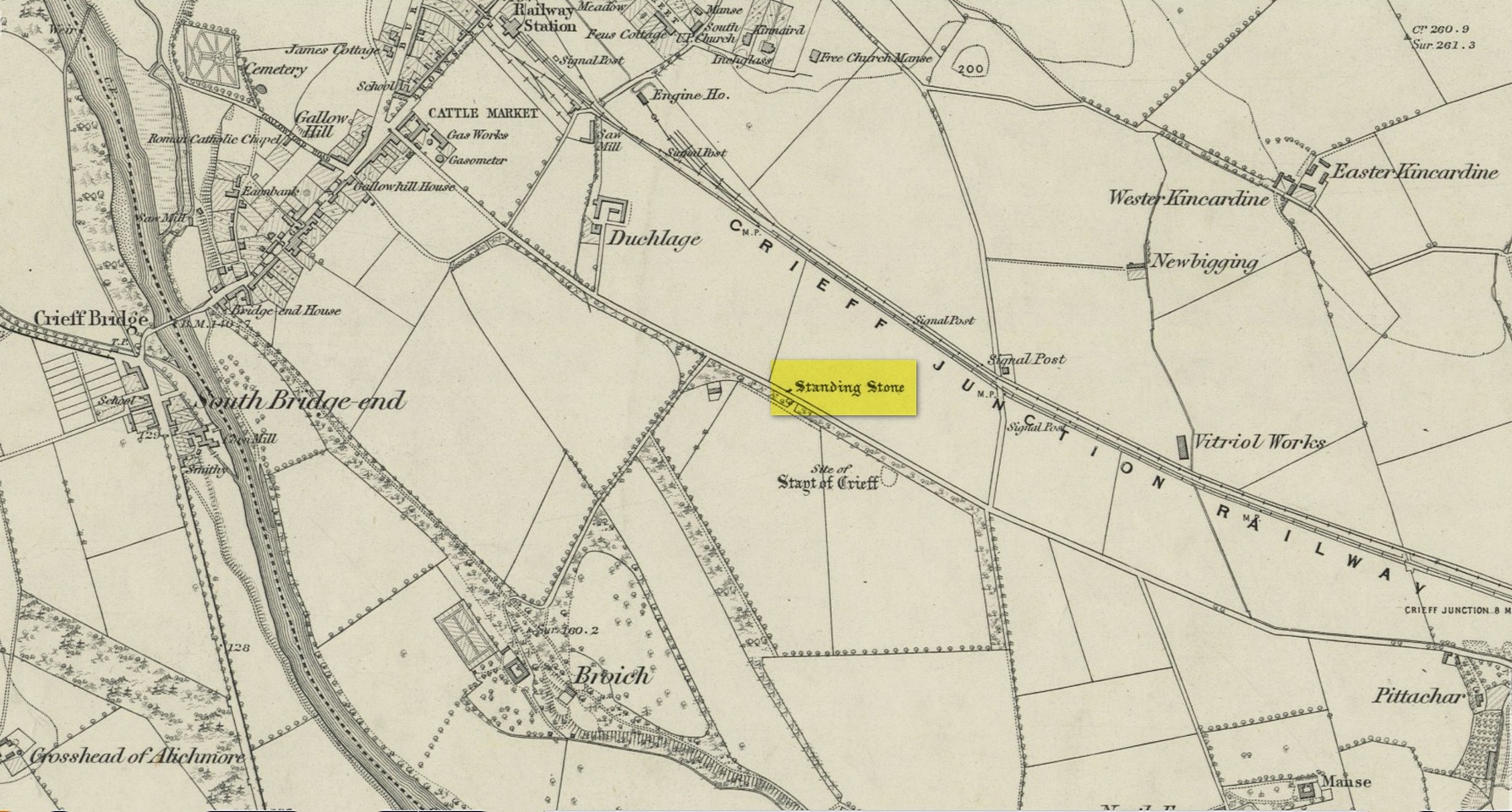
Standing Stone (destroyed): OS Grid Reference – NN 8655 2079
Archaeology & History
Site on the 1866 map
There is seemingly no trace left of this once impressive tall, slender standing stone that had lived for thousands of years on the south-side of Crieff. It was destroyed by some retard in the middle of the 20th century (anyone know their name?). Highlighted on the 1866 Ordnance Survey map of the area, it was visited and described by the late great Fred Coles (1911) when it still stood at the side of the road. He told that it was,
“In shape a narrow rhomboid at the base, this Stone rises to an acute angle at a height of 6 feet. Its longer axis is E.S.E. 52° by W.N.W. 52°, and in basal girth it measures 8 feet 11 inches.”
Coles’ 1911 sketch
Some 200 yards to the south-east there used to be the curiously-named Stayt of Crieff burial mound which had been used as a court hill for many centuries. This outlying standing stone may have been the “witness” on which oaths were sworn before the court. Sadly the history of the Stayt of Crieff mound is also somewhat sparse and it too has, appallingly, been destroyed. The destruction of these antiquities and their ancient traditions is nothing short of a fucking disgrace.
Finlayson, Andrew, The Stones of Strathearn, One Tree Island: Comrie 2010.
Acknowledgements:Huge thanks for use of the Ordnance Survey map in this site profile, reproduced with the kind permission of the National Library of Scotland.
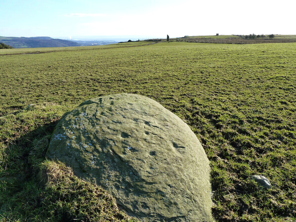
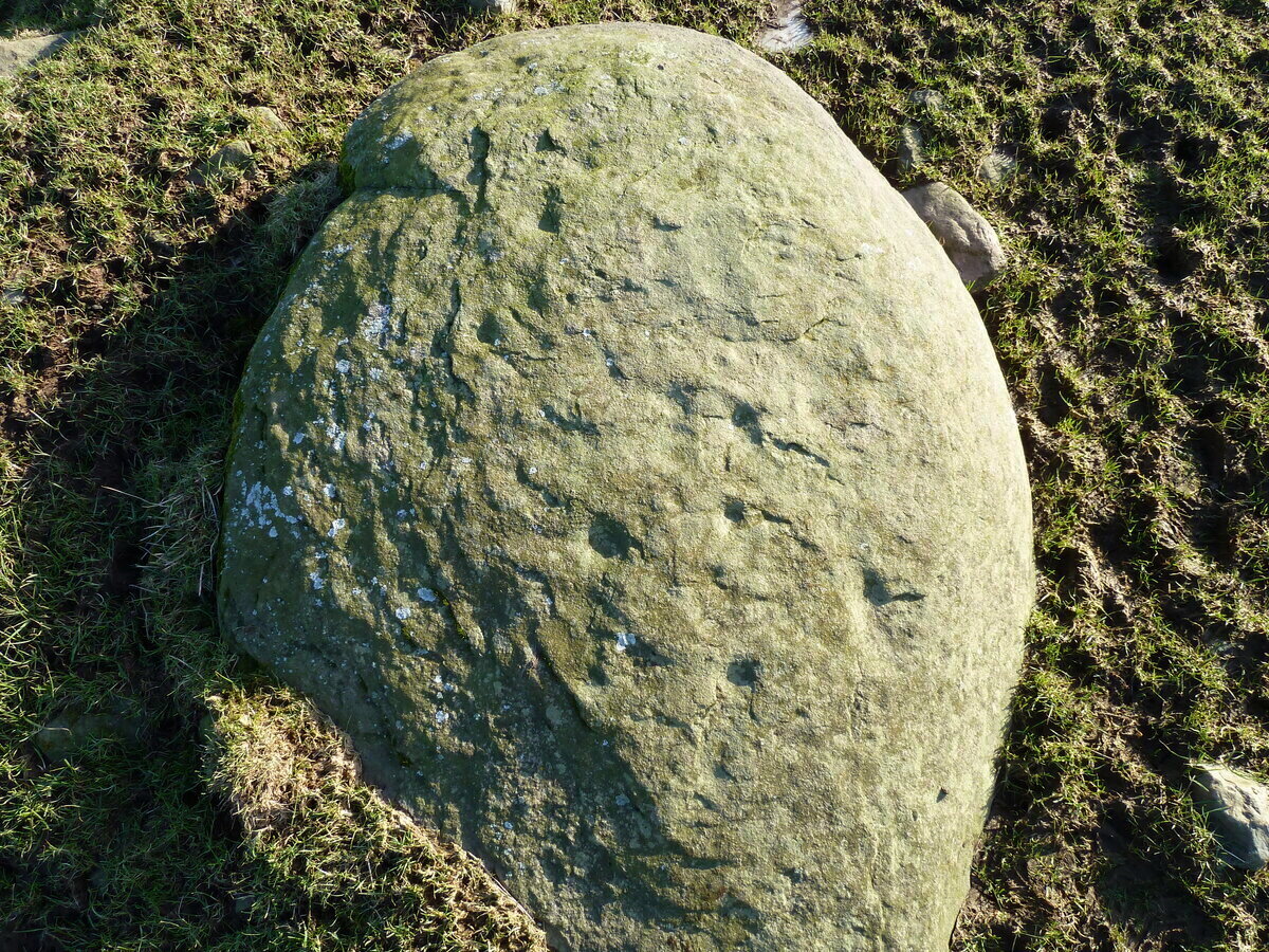
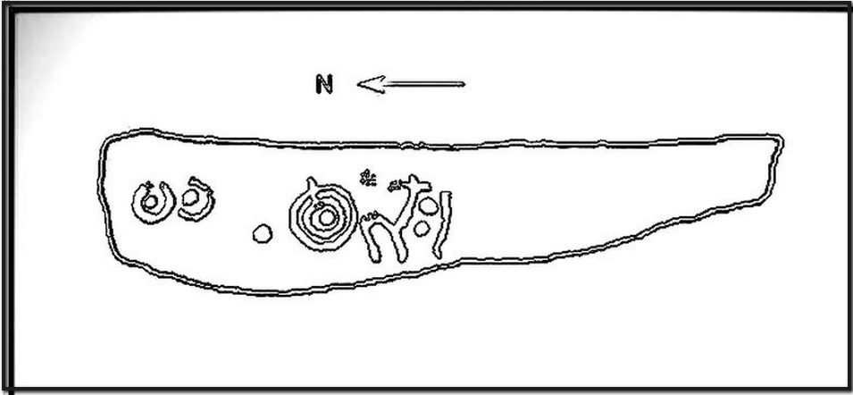
An interesting new cup-marked stone found by Paul Blades is this smooth rounded (female) stone that may originally have had some relationship with the tall standing stone of Careg Bica 160 yards to the south. Around ten cup-marks are etched onto its surface, in a seemingly random arrangement (as usual!). Although it seems to be an isolated carving, it’s likely that others will exist in the area.
Carving & outlying monolithCareg Bica petroglyph
The direction and proximity of the standing stone may have had some relationship with the carving. In traditional northern hemisphere societies, the cardinal direction North is generally associated with darkness and death, primarily due to the fact that this is the area in the heavens where neither sun or moon ever appear; whilst South relates to life and positive natural associations due to it being the high point of the sun during the day. This animistic attribute existed till recently in the water-lore of northern England and Scotland where “south-running streams bore a high repute.” Whilst such mythic attributes are well established, any cardinal relationship here is purely speculative.
Acknowledgements: Huge thanks to Paul Blades for use of his photos in this site profile – and of course for finding the stone!
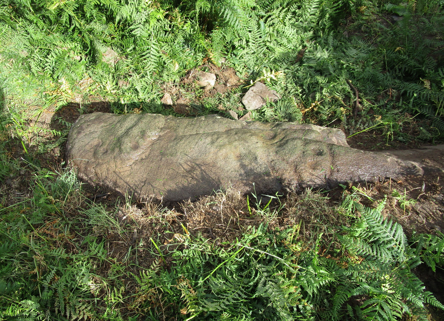
If you’re coming up from Otley or Askwith, take the same directions as if you’re going to visit the impressive Naked Jogger Carving (stone 612), not far from the well-known Tree of Life Stone. From the Naked Jogger carving, walk up to the small outcrop of rocks that bends above you. There’s a small collapsed line of walling just behind the outcrop. Walk along this up the slope as if you’re heading for the Sunrise Stone carving, but only 30 yards along, low down and right into the edge of the wall itself, you’ll see this elongated piece of stone. That’s the spot!
Archaeology & History
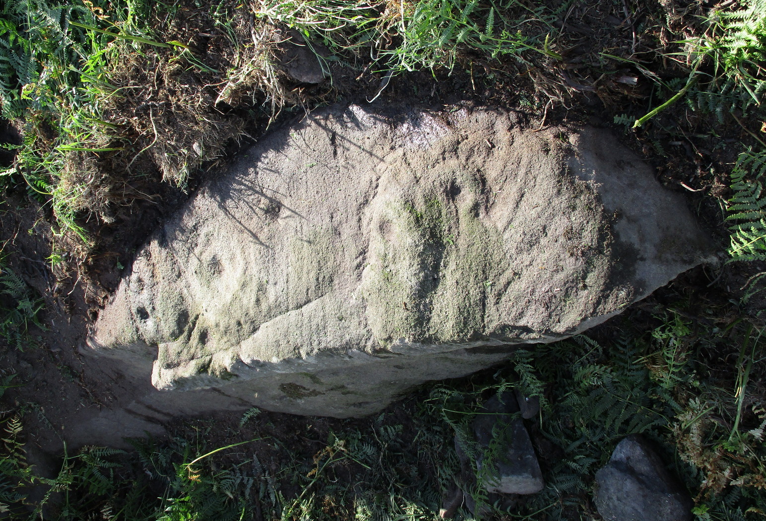
If you’ve caught the petroglyph-bug, you’ll like this one! It received its name from the curious fusion of natural cracks with the man-made pecked lines that shows, quite distinctly when the light is right and the stone is wet, the outline of two humanesque forms joined to each other. Figurative rock engravings of ancestors in the UK are extremely rare and when we came across this example, we noticed how the design could be interpreted as two Askwith Moor ancestor figures. Figurative rock art images elsewhere in the world such as the magnificent Wandjina paintings and the extensive galleries of figures engraved at Murujuga (Burrup Peninsula) in Western Australia, might provide an initial comparison, though more specific work needs to be done to better understand this unique petroglyph.
Sketch of the carving
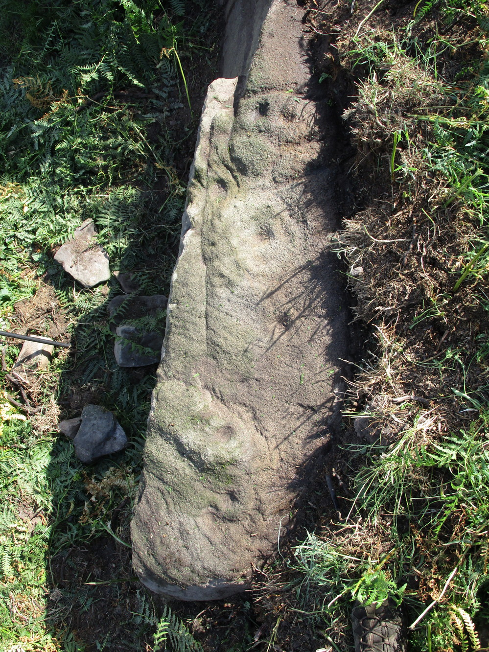
You can almost make out the figures in the above photo: the upper torsos of two beings on the right-hand side of the rock, almost fused together. And the carved shapes of these “ancestral beings” are morphically similar to some elements in the Sunrise Stone just 50 yards away – which themselves remind me of a Northumbrian carving near Doddington known as West Horton 1a. (Beckensall 1991) But we should’t get too carried away by the idea because—as we can see here in the sketch of the carving—when looked at from a different angle above, we could infer the right-hand carved elements to be representative of an animal: a deer, perhaps. Rorscharch’s once more tickle the exploring mind….
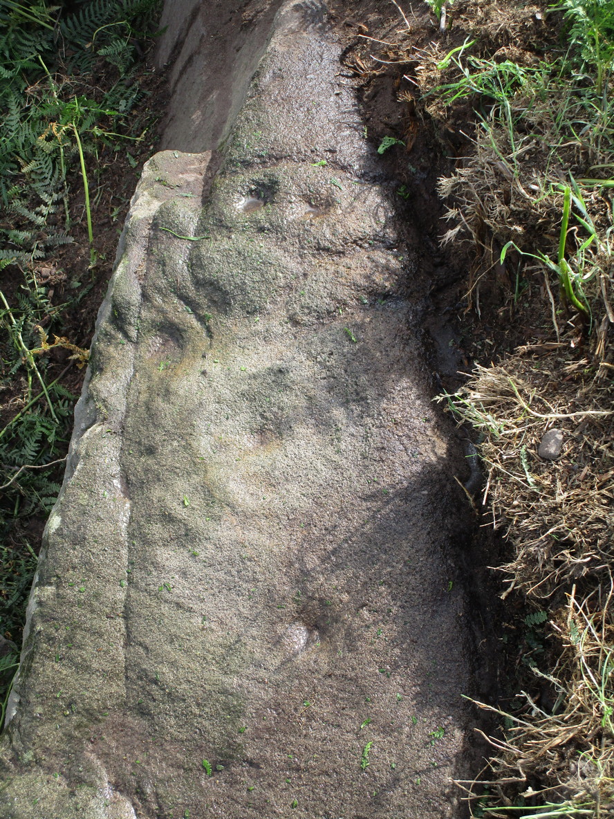
The rock has been quarried into at same time in the past (just like the nearby Sunrise Stone), leaving us to wonder what the complete carving might have looked like. No doubt some pieces of it will be in the collapsed walling either side of the stone. All we have left to see are the two unfinished cup-and-rings above the natural cracks that give rise to the “ancestral being” appearance. The faint double cup-and-ring has curious linear arcs to its side, with two well-defined cups enclosed by two of them. It’s a nice-looking carving when the light is good. The petroglyph was carved over a long period of time, as evidenced by the differing levels of erosion in different sections of the design. It’s a common attribute. The oldest section is the faint double cup-and-ring, whose mythic nature was added to / developed at a much later date, perhaps even centuries later.
In the always-expressive archaeocentric description of Boughey & Vickerman’s (2003) otherwise valuable tome, they told this carving to be,
“Long, narrow, thick rock of medium grit. Six cups, one with a double ring with a tab out and two with at least partial single rings, grooves.”
Evocative stuff!
It’s very likely that this carving had some mythic relationship with its close neighbours either side of it, probably over a very long time period and I’m inclined to think it somehow related to the rising of the sun, just like its solar companion further up the slope. Please note how I emphasize this ingredient in the site profile of its neighbour, the Mixing Stone 10-15 yards away—roughly halfway between this and the Sunrise Stone. A distinct place of ritual was happening in this close-knit cluster of carvings…
References:
Beckensall, Stan, Prehistoric Rock Motifs of Northumberland – volume 1, 1991.
Boughey, Keith & Vickerman, E.A., Prehistoric Rock Art of the West Riding, WYAS: Leeds 2003.
Reeder, Phil, “Snowden Carr Rock Carvings,” in Northern Earth Mysteries, no.40, 1990.
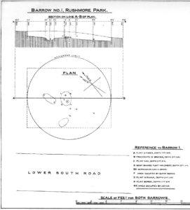
In what today seems a barely visible tumulus, amidst the large cluster that could once be found upon the large estate grounds of Rushmore House, were once the overgrown ruins of an old tumulus. It seems to have been rediscovered in the 19th century, when the legendary antiquarian, General Pitt-Rivers, moved onto the huge estate. It was all but hidden even in his day, he told, but being “of such slight elevation that, like many others, it had never been noticed.” It was the first of all the barrows they excavated on his Estate, and is to be found “near the house on the south side of the lower south coach road.”
So, in 1880, he got some of the estate lads to help him and Rolleston start a dig into the old tomb – and they weren’t to be disappointed. It wasn’t anything special, but it was the first amongst many hereby. In Pitt-River’s (1888) massive tome on the prehistory of the region, he told us:
“This was the first barrow opened at Rushmore, on the 10th August, 1880. Professor Rolleston and the Rev. H. Winwood were present at the opening. The elevation was so slight that it had hitherto escaped notice. In the centre, 1 foot 6 inches beneath the crest, a layer of charcoal and ashes, 9 feet by 6 feet, was found containing a burnt body. The body appears to have been burnt on the spot, and not gathered up after cremation, but a mound raised over the funereal pile. A few fragments of bronze, probably the remains of some implement which had corroded or been burnt, were found in the ashes, and in the body of the barrow two flint scrapers, a well-formed flint borer, and a boat-shaped flint…were found (see illustration above, PB). A few scattered fragments of pottery found in the barrow were of a superior and harder baked quality than is usual in barrows. No trace of a ditch was found around the barrow, but towards the north of the centre, a depression—EE on plan—which might, or might not, have been a grave, but filled with mould and without remains, was discovered. The barrow is undoubtedly of the Bronze Age, and is interesting on account of it being the last at the opening of which Professor Rolleston assisted shortly before his death.”
As a result of this, he decided to name to barrow after his old friend and also planted a beech tree on top of it in remembrance of him.
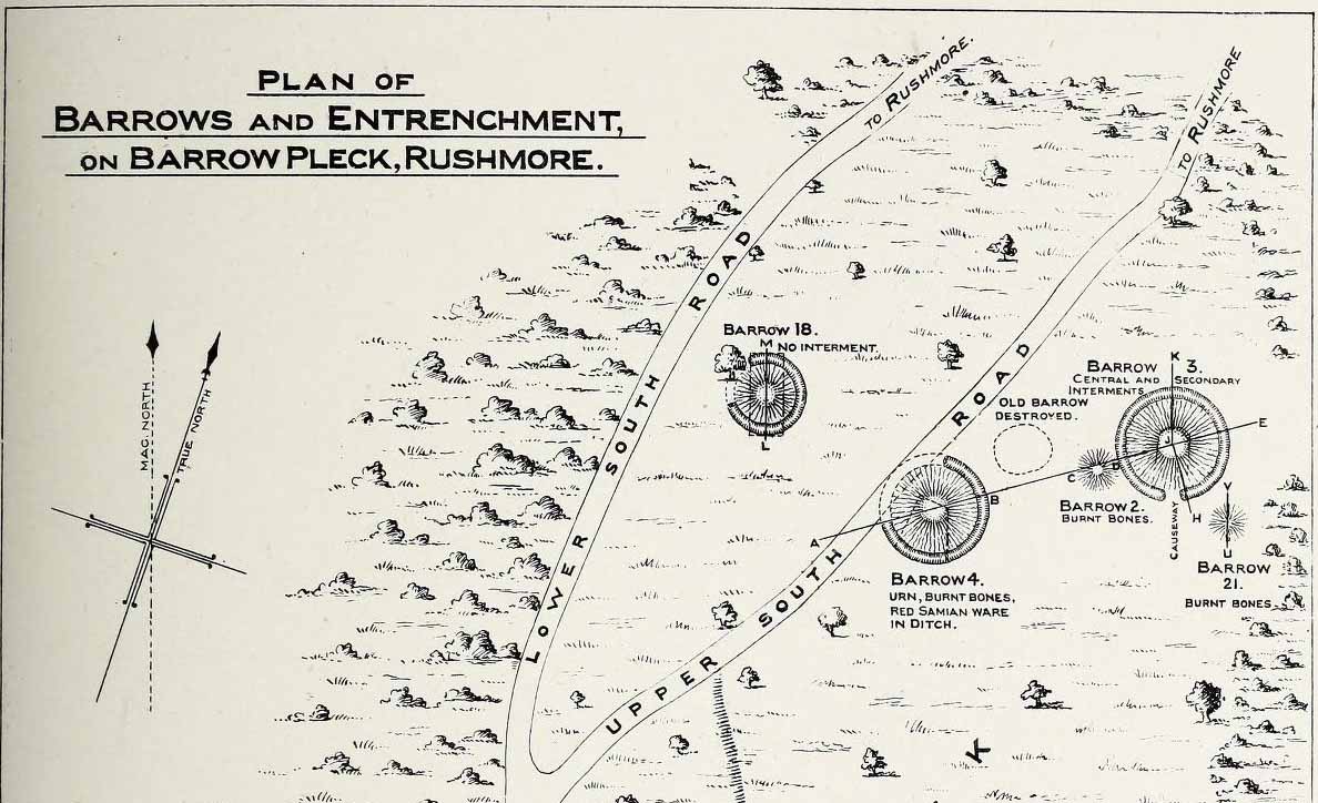
This long-lost burial mound was one in a large group of prehistoric tombs that were explored in the 19th century by the legendary antiquarian, General Pitt-Rivers. It had already been destroyed before the General came to live on his Rushmore estate in southern Wiltshire, but thankfully, his diligence as an inquirer prevailed and he was able to recover at least something of the old site. Shown on the 1889 OS-map of the area (despite already having been destroyed), in Pitt-River’s (1888) extensive writings he told how, in the scattered woodlands hereby, was
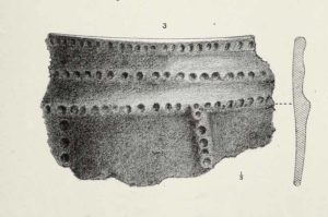
Pitt-Rivers 1888 site-mapOld Pleck Barrow urn
“a collection of large barrows near the South Lodge. They were covered with a thick grove of hazel and other underwood. One of the barrows—marked by a dotted circle (see sketch-map, left, PB)—had been destroyed before my arrival at Rushmore in 1880. The earth of the barrow had been removed and a good urn found in it, which had been broken and scattered, but I was fortunate enough to recover one of the fragments which had been preserved by the estate carpenter.”
From a sketch that was made of the urn remnant, Pitt-Rivers told how “the character of its ornamentation” resembled that on another urn found in one of the nearby tumuli.
References:
Pitt-Rivers, A.H.L.F., Excavations in Cranborne Chase, near Rushmore – volume 2, Harrison & Sons: London 1888.
Tumulus (destroyed): OS Grid Reference – SP 2946 3090
Archaeology & History
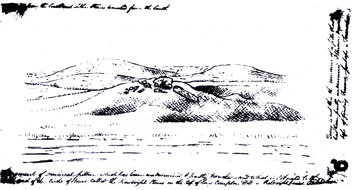
Only known drawing of Gough’s Barrow
In days of olde there were heathen sites around the edges of the beautiful Rollright Stones complex that have sadly fallen prey to the intensive agriculture of more modern ‘civilized’ times. It’s become the way of things….. One site of importance in this geomythic pantheon was the ‘Gough’s Barrow’—so named after a drawing was done of the site by Richard Gough, editor of the 1789 edition of Camden’s Britannia. As far as I’m aware, it is the only one ever done of this monument. The Oxford archaeologist George Lambrick (1988) saw “every reason to accept the position and details of the barrow”, upon which stood at least two large stones—one of which gained the description of a ‘druidical pillar.’
Stukeley’s 1743 drawing
The same barrow may have been recorded in one of drawings of the great William Stukeley, who visited the Rollright Stones in 1710 and then again in 1723. On the left-side of the adjacent drawing you can see a denuded mound close to the edge of the picture, similar in shape and form to that drawn by Richard Gough. It is probably the same tumulus or barrow. Trial excavations at the site in 1983 looked for any remains of the old tomb, but nothing significant was uncovered. Lambrick estimated that the site probably measured “about 18m wide and 20m long east-west,” and “was a megalithic barrow and was therefore probably Neolithic in origin.”
References:
Bennett, Paul & Chanter, James, The Complete Rollright Stones, forthcoming
Bennett, Paul & Wilson, Tom, The Old Stones of Rollright and District, Cockley Press: Chipping Norton 1999.
Burl, Aubrey, Great Stone Circles, Yale University Press 1999.
Lambrick, George, The Rollright Stones, English Heritage 1988.
Long Barrow (destroyed): OS Grid Reference – TL 086 268
Archaeology & History
Aligned east-west, a large neolithic long barrow could once be seen to the west of Galley Hill, on where now we find a golf course. It was sadly destroyed sometime around 1900 AD and its demolition was witnessed by a Mr A. Cumberland of the Dartford Antiquarian Society, who reported there being no archaeological finds of note in the tomb. Curious…
Equally curious was the view of archaeologist James Dyer (1964) in his assessment of the site, who wrote how
“Air photographs suggest that the barrow was 300 ft long, but this is much larger than normal in the Chilterns, and 150 ft is more reasonable.”
The neolithic and Bronze Age burial specialist Paul Ashbee (1984) maintained the “300 feet” measurement.
Other tumuli can still be seen on the slopes either side of Galley Hill a few hundred yards to the east; and a henge monument has also be found in the area.
References:
Ashbee, Paul, The Earthen Long Barrow in Britain, Geo: Norwich 1984.
Dyer, J.F., “A Secondary Neolithic Camp at Waulud’s Bank, Leagrave,” in Bedfordshire Archaeological Journal 2, 1964.
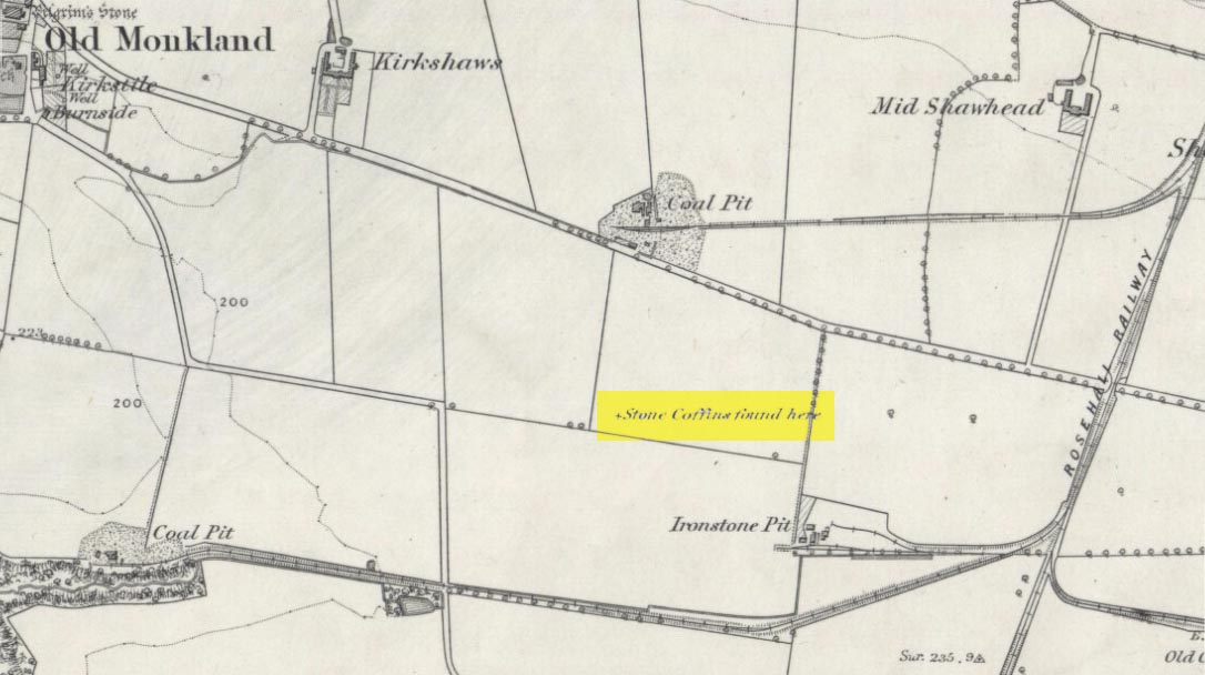
On the flat meadowlands below the slopes of Old Monkland, half-a-mile southeast of the legendary Pilgrim’s Stone, an old mound once lived. It may have been here for thousands of years but, with the encroachment of the toxic Industrialists, its time was coming to an end. The mound was levelled in 1832 and, beneath it, relics from a truly ancient past were unearthed – and destroyed of course. The account of its demise was told in the Glasgow Evening Post of May 26 that year. Many years later, the Royal Commission (1978) lads unearthed the information and included the site in their inventory for prehistoric sites in Lanarkshire. They told:
“In 1832 four cists were discovered during the levelling of a small mound 900m SE of Old Monkland Church. The cists, which measured about 1m by 0.6m, contained the remains of crouched inhumations, two of them double burials with the skulls at opposite ends of the cists. A stone hammer-head and a coin were found in one cist, the latter no doubt indicating subsequent disturbance. There is now no sign of the site, and it is not certain from the report whether the cists were inserted into a small natural mound or were covered by a barrow.
“The present farmer states that his father discovered a single cist during ploughing in the same field; it contained a pottery vessel which the landowner, Mr Sholto Douglas, was thought to have presented to a museum, but it cannot now be traced.”
References:
Royal Commission on the Ancient & Historical Monuments of Scotland, Lanarkshire: An Inventory of the Prehistoric and Roman Monuments, HMSO: Edinburgh 1978.
Tumulus (destroyed): OS Grid Reference – TA 4160 1748
Archaeology & History
In and around East Yorkshire, the fabled Yorkshire antiquarians William Greenwell and J.R. Mortimer uncovered and excavated many now-lost prehistoric tombs—some of which, beneath the rounded tumulus of earth, were constructed out of wood instead of stone. A little-known site, now long gone, once existed in what is now the North Sea, just a few hundred yards off the Easington coast. Other sites close by are soon to be completely swallowed back into Earth’s body, right on the water-line, but the site described here has long gone. What little was known of it was described in Mortimer’s (1905) magnum opus, where he told:
“On the beach at Easington, in Holderness, under a tide-demolished barrow, Dr Hewetson and the writer on April 21st, 1894, discovered a double cist made of broad slabs split from the outer shell of the decayed trunk of a willow tree. This barrow had been swept away by the waves, and its site was at about half-tide-line, and a considerable way from the very low cliffs. Lining the grave with wood (the branches of trees) would not be difficult to accomplish and would be practised as a protection to the body.”
A henge monument and several other prehistoric barrows have been located in and around Easington, but they’re fading fast!
References:
Mortimer, J.R., Forty Years Researches in British and Saxon Burial Mounds of East Yorkshire, A. Brown: London n.d. (1905).
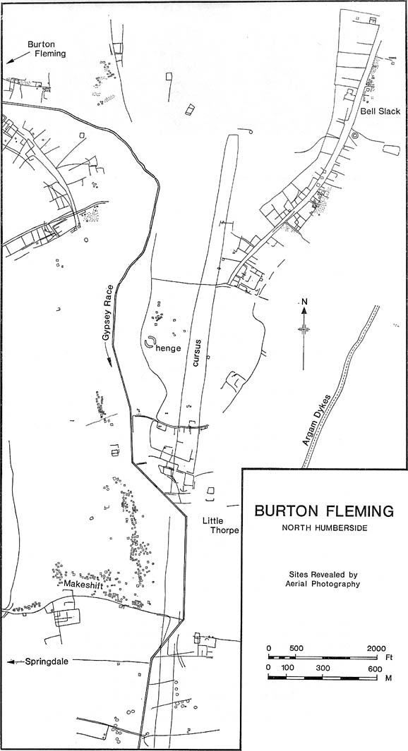
Plan of Rudston D Cursus & associated monuments (after I.M. Stead 1976)
To the north of Rudston village and its giant standing stone, running roughly parallel with the divinatory waters of the Gypsey Race river and passing a mass of prehistoric remains en route, we find one the biggest prehistoric cursus monuments in the British Isles: the Rudston D cursus. More than twice as long as any of the three other cursus monuments nearby, its northern end or ‘terminal’ is flattened in nature (others are rounded) and is due east of the village of Burton Fleming starting at the intriguingly-named Maidens Grave field, just as the land begins to rise at TA 099 717. From here it begins its almost southern trajectory and runs almost dead straight for several hundred yards until edging, ever so slightly in direction, to a slightly more secure southern alignment. Past the site of the Rudston henge, the cursus broadens out slightly and, as it reaches the farmlands of Littlethorpe, edges slightly further to a more decisive direct southern route. The cursus then maintains a dead straight course for another mile, heading straight for, and stopping just short of the Rudston monolith in its modern churchyard. A short distance before we reach its southern end, archaeologists found that a section of the Cursus C monument cut right across it. Altogether, the Rudston D Cursus is more than 4km (2.3 miles) long! At its narrowest width, this monument is a mere 160 feet (50m) across, and at its widest is 280 feet (90m). A giant by anyone’s standard!
Along the entire length of this continuous ditch and inner bank there were just 3 small cuttings on the western side and three on the east, but two of the eastern openings were quite large. Some of these openings were affected by natural elements and others by modern agriculture. Today, much of this gigantic ritual monument (as the archaeologists call them) is not visible at ground level.
In visiting this area, make yourself aware of the other monuments in this class: the Rudston A cursus and Rudston B cursus, southeast and southwest of here respectively. A full multidisciplinary analysis of the antiquities in this region is long overdue. To our ancestors, the mythic terrain and emergent monuments hereby related to each other symbiotically, as both primary aspects (natural) and epiphenomena (man-made) of terra mater: a phenomenon long known to comparative religious students and anthropologists exploring the animistic natural relationship of landscape, tribal groups and monuments.
References:
Burl, Aubrey, Rites of the Gods, J.M. Dent: London 1981.
Harding, Jan, ‘Pathways to New Realms: Cursus Monuments and Symbolic Territories,’ in Barclay & Harding, Pathways and Ceremonies: The Cursus Monuments of Britain and Ireland, Oxbow: Oxford 1999.
Loveday, Roy, Inscribed Across the Landscape: The Cursus Enigma, Tempus: Stroud 2006.
Pennick, Nigel & Devereux, Paul, Lines on the Landscape, Hale: London 1989.
Stead, I.M., ‘La Tene Burials between Burton Fleming and Rudston,’ in Antiquaries Journal, volume LVI Part II, 1976.