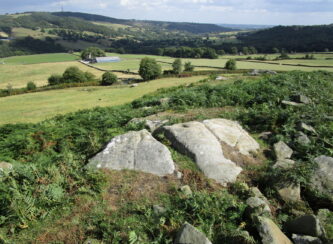
Follow the directions to reach the Ancestors’ Stone and the Sunrise Stone; and there, roughly halfway between them, right by the edge of the old collapsed walling, you’ll see this rise of a stone with a large ‘bowl’ on top. That’s it!
Archaeology & History
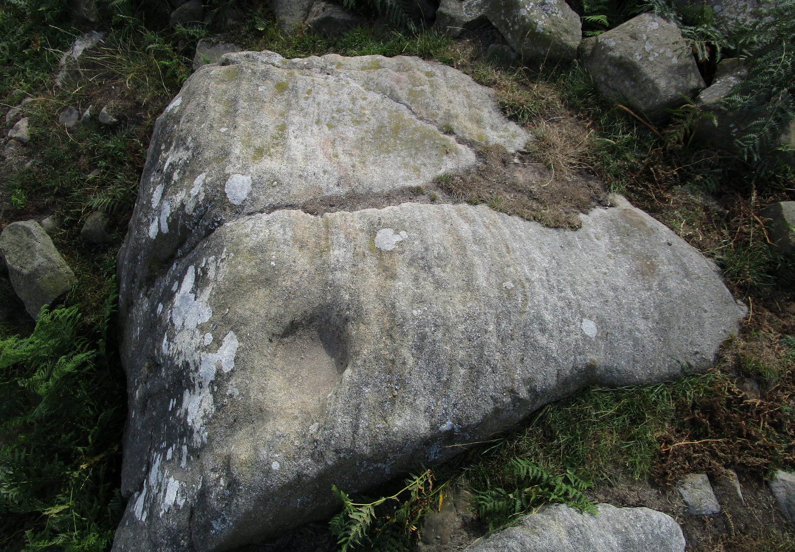
Mixing Stone, looking E
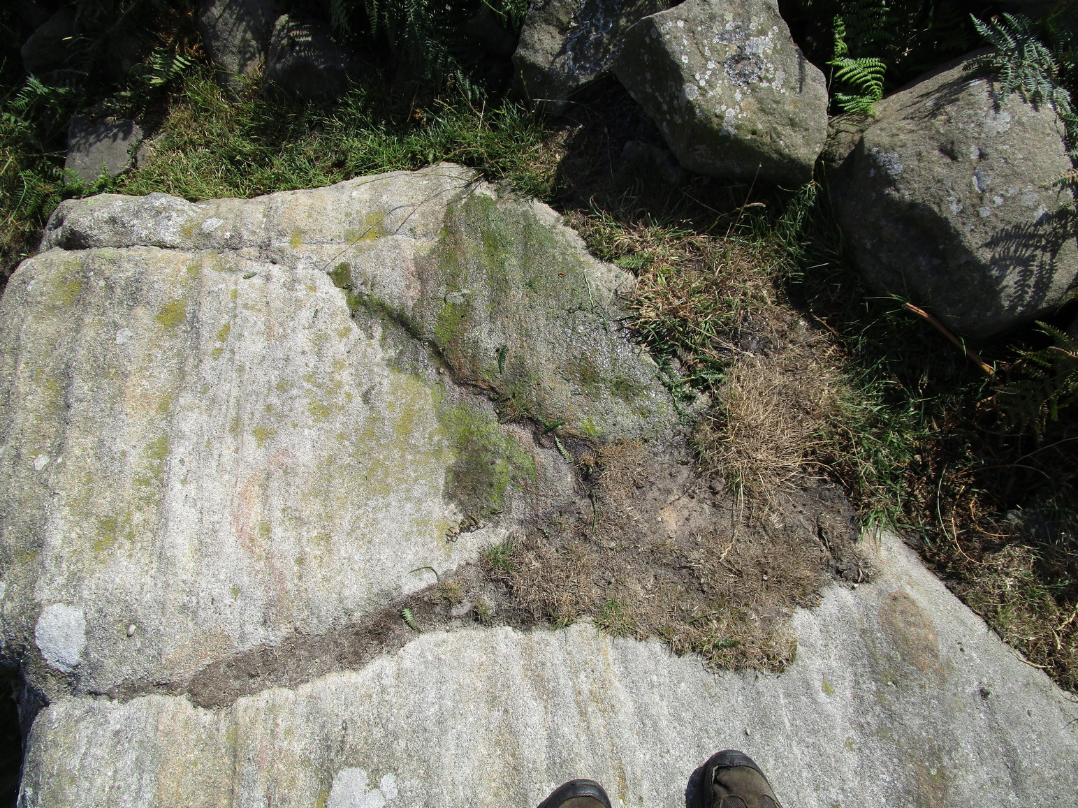
Laid upon the same geological ridge as our Ancestors’ and Sunrise carvings, there are one, possibly two faint cup-marks visible on the low flat surface near the edge of this rock, barely visible unless the light’s right. But the important element here, perhaps regardless of the cup-marks, is the ‘bowl’ or rock basin on top of the stone. Internally, it’s smoothed equally on all sides and, due to being in-between the two impressive petroglyphs, may well have had a practical function to it. Bear with me on this one…
The Mixing Stone’s bowl
Stone ‘bowls’ or cavities—natural and otherwise—have been made use of in many cultures for simple functional purposes, such as grinding flour, herbal mixes, etc. We find such traditions in some of the bullauns of Ireland and Scotland; whereas in similar stone bowls known as cat troughs in nearby Haworth, milk was poured to appease the spirits of the land (this tradition was still being maintained in 2001!). Folklore and traditions of such rock basins spread far and wide beyond the UK: one of the German terms for rock basins is Opferkessel, meaning ‘sacrificial basin’ and suggests ritualistic usage by early societies. Elsewhere on Earth there are numerous accounts of the ritual use of petroglyphs in which indigenous peoples tell of their use of plant- or rock-based paints (in many cases red ochre) to decorate the carvings. And it’s this element that I’m interested in here.
Water-painted cupmarks
The Sunrise and Ancestors’ Stones 10-15 yards either side of this Mixing Stone are ideal candidates for such petroglyphic paintings using early ochre and other stone or plant-based agents. Such activities would always have been ritualised, either in honour of ancestors, genius loci, calendrical rites, or whatever the pertinent ingredient was at that place and time. I’m suggesting simply that the rock basin on the Mixing Stone was used for just such purposes. This is no spurious suggestion, but at the same time it’s important to recognise that my thoughts here represent merely an idea, nothing more—not a fact. Whilst we know full well that these carvings were imbued fundamentally with animistic properties—a simple ‘fact’—this functional idea is just that—an idea. Students and petroglyph-nuts need to understand this. And the faded cup-marks at its edge are perhaps merely incidental…. though I don’t buy that misself!
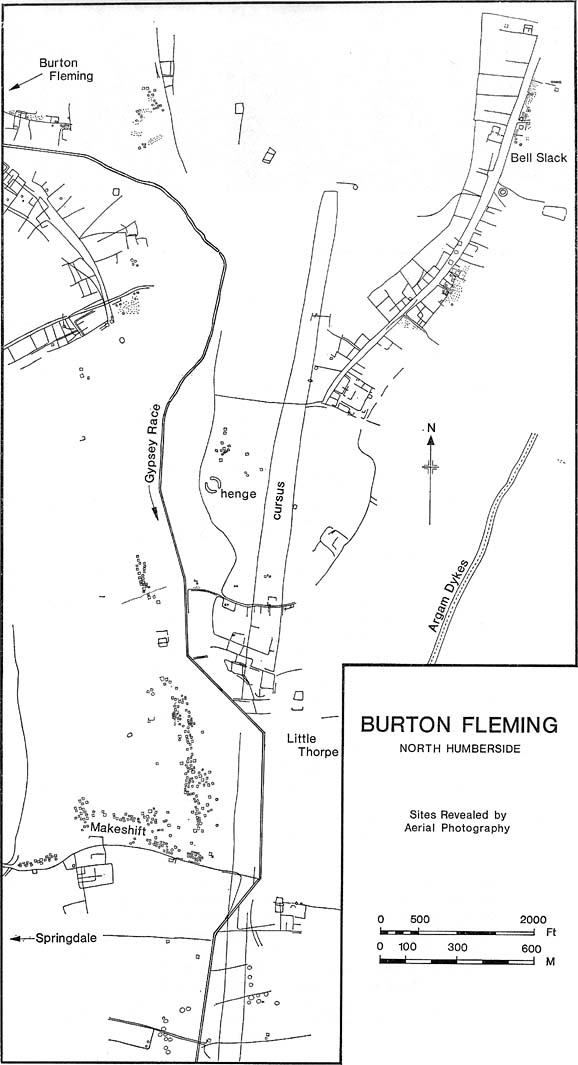
Plan of Rudston D Cursus & associated monuments (after I.M. Stead 1976)
To the north of Rudston village and its giant standing stone, running roughly parallel with the divinatory waters of the Gypsey Race river and passing a mass of prehistoric remains en route, we find one the biggest prehistoric cursus monuments in the British Isles: the Rudston D cursus. More than twice as long as any of the three other cursus monuments nearby, its northern end or ‘terminal’ is flattened in nature (others are rounded) and is due east of the village of Burton Fleming starting at the intriguingly-named Maidens Grave field, just as the land begins to rise at TA 099 717. From here it begins its almost southern trajectory and runs almost dead straight for several hundred yards until edging, ever so slightly in direction, to a slightly more secure southern alignment. Past the site of the Rudston henge, the cursus broadens out slightly and, as it reaches the farmlands of Littlethorpe, edges slightly further to a more decisive direct southern route. The cursus then maintains a dead straight course for another mile, heading straight for, and stopping just short of the Rudston monolith in its modern churchyard. A short distance before we reach its southern end, archaeologists found that a section of the Cursus C monument cut right across it. Altogether, the Rudston D Cursus is more than 4km (2.3 miles) long! At its narrowest width, this monument is a mere 160 feet (50m) across, and at its widest is 280 feet (90m). A giant by anyone’s standard!
Along the entire length of this continuous ditch and inner bank there were just 3 small cuttings on the western side and three on the east, but two of the eastern openings were quite large. Some of these openings were affected by natural elements and others by modern agriculture. Today, much of this gigantic ritual monument (as the archaeologists call them) is not visible at ground level.
In visiting this area, make yourself aware of the other monuments in this class: the Rudston A cursus and Rudston B cursus, southeast and southwest of here respectively. A full multidisciplinary analysis of the antiquities in this region is long overdue. To our ancestors, the mythic terrain and emergent monuments hereby related to each other symbiotically, as both primary aspects (natural) and epiphenomena (man-made) of terra mater: a phenomenon long known to comparative religious students and anthropologists exploring the animistic natural relationship of landscape, tribal groups and monuments.
References:
Burl, Aubrey, Rites of the Gods, J.M. Dent: London 1981.
Harding, Jan, ‘Pathways to New Realms: Cursus Monuments and Symbolic Territories,’ in Barclay & Harding, Pathways and Ceremonies: The Cursus Monuments of Britain and Ireland, Oxbow: Oxford 1999.
Loveday, Roy, Inscribed Across the Landscape: The Cursus Enigma, Tempus: Stroud 2006.
Pennick, Nigel & Devereux, Paul, Lines on the Landscape, Hale: London 1989.
Stead, I.M., ‘La Tene Burials between Burton Fleming and Rudston,’ in Antiquaries Journal, volume LVI Part II, 1976.
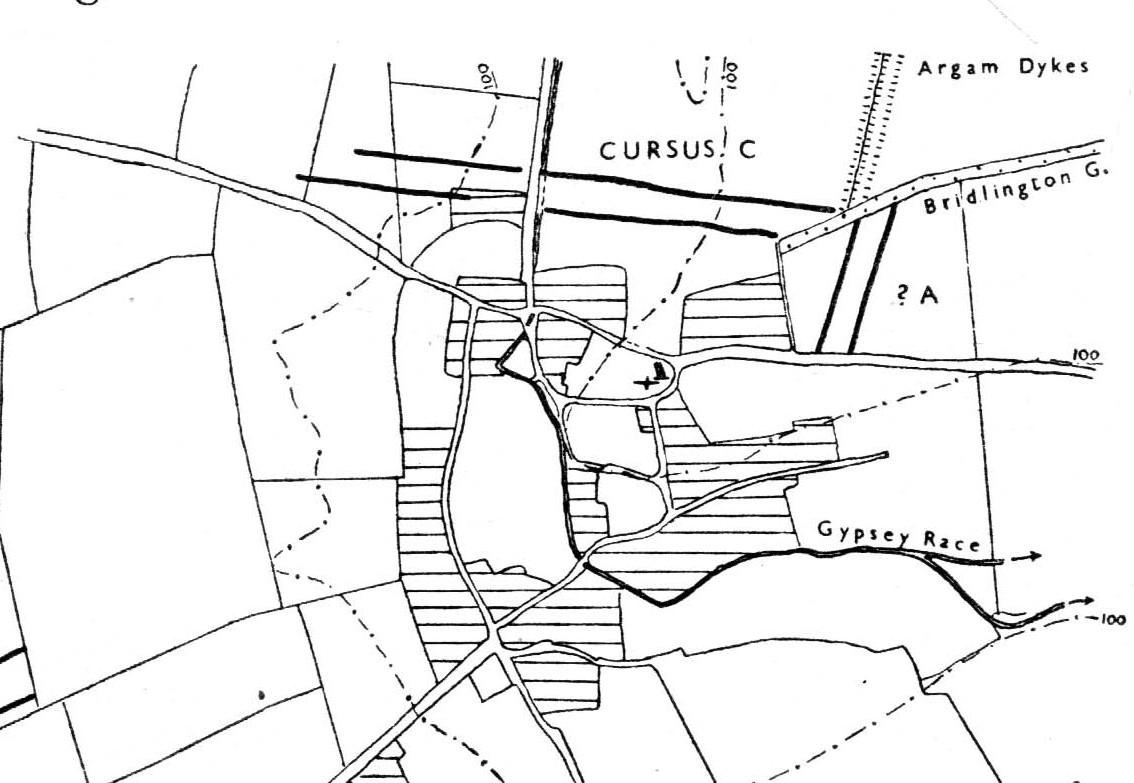
Of the four giant linear cursus monuments that were laid out around the landscape that holds Britain’s largest standing stone—the Rudston monolith—this one, the Rudston ‘C’ cursus, is the one we know the least about. This is mainly due to it receiving the minimum of archaeological attention, which can be forgiven round here as there is so much material to explore! Traces of the cursus at ground level are also quite negligible. Thankfully however, like the other cursus monuments nearby, some of the site can be made out on GoogleEarth.
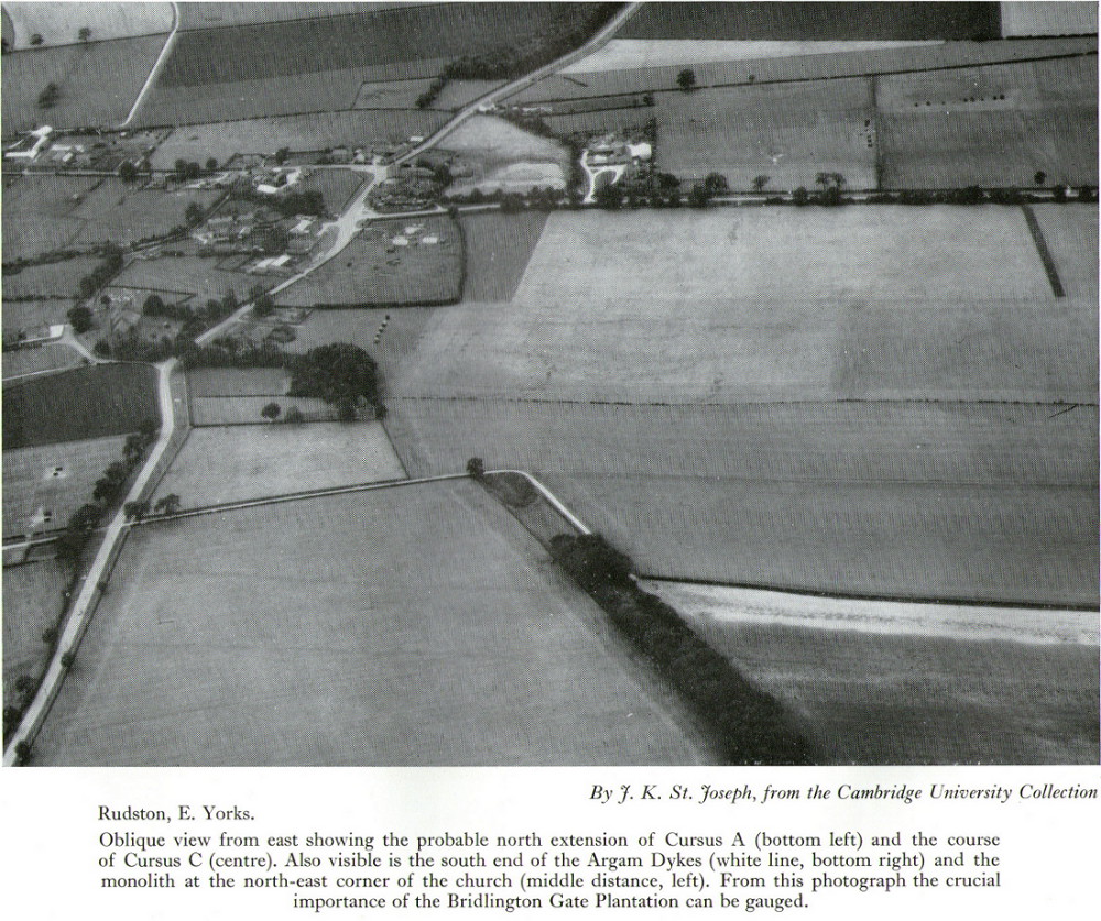
The alignment of this cursus runs east-to-west, cutting across the Cursus D monument and then running above the northern course of Nature’s curious river known as the Gypsey Race, which local folklore ascribes as being used in animistic divinatory practices. Cursus C was first noticed in aerial photographs taken by Prof. J.K. St. Joseph in 1961 and first described by D.P. Dymond (1966) a few years later, who told us:
“Immediately north of the village (Rudston), two parallel ditches, about 60 yards apart, are visible as crop-marks running east-west for 1000 yards… As they are too far apart to be considered as road-ditches and are similar to the linear ditches (of Rudston A and B), they are best interpreted as a fragment of a third cursus, C. The western end fades out near the York road as it climbs onto high ground, while at the east the ditches disappear into Bridlington Gate Plantation. Like Cursus A, this also crossed the Gypsey Race. Approximately 1½ miles northwest of the last westward point of these ditches is the presumed site of two lost long barrows, joined together at one end. There may, therefore, have been an original connection between Cursus C and these long barrows.”
First faint photo of Cursus C
His final remark is quite a good one! And since Dymond’s initial description (according to the PastScape lads anyhow), Cursus C has been found to be much longer than the initial 1000 yards, growing another 500 yards at least! The final point or ‘terminal’ on the eastern end still remains hidden, as it was intruded upon by the later Argham Dyke and the trees. The start or western terminal also remains unfound, so we don’t know for sure the exact length of this giant neolithic ‘line on the landscape’, as Pennick and Devereux (1989) call them.
References:
Dymond, D.P., “Ritual Monuments at Rudston, E. Yorkshire, England,” in Proceedings of the Prehistoric Society, volume 32, 1966.
Harding, Jan, ‘Pathways to New Realms: Cursus Monuments and Symbolic Territories,’ in Barclay & Harding, Pathways and Ceremonies: The Cursus Monuments of Britain and Ireland, Oxbow: Oxford 1999.
Loveday, Roy, Inscribed Across the Landscape: The Cursus Enigma, Tempus: Stroud 2006.
Manby, T.G., “The Neolithic in Eastern Yorkshire,” in Archaeology in Eastern Yorkshire, University of Sheffield 1988.
Pennick, Nigel & Devereux, Paul, Lines on the Landscape, Hale: London 1989.
Stead, I.M., ‘La Tene Burials between Burton Fleming and Rudston,’ in Antiquaries Journal, volume LVI Part II, 1976.
Any remains of this once sacred site are now beneath the airport between Benson and Ewelme, a couple of miles northeast of Wallingford, on the eastern side of the River Thames. A great pity. It was one of the early cursus monuments discovered as a result of Major G.W. Allen’s many aerial surveys in southern England — as shown in his photo here — and subsequently described in Mr Leeds’ (1934) Antiquaries Journal article. A cluster of cursus monuments were built in this part of England in neolithic times, and Roy Loveday (2006) includes the Benson Cursus as an ingredient within the ‘sacred landscape’ region of what he calls “the Dorchester-on-Thames complex.” The Benson Cursus and surrounding regional monuments,
“in fact possesses features that would declare it as an inter-regional sanctuary if encountered in an historical setting; namely, intensity of monument construction, longevity of respect, addition of later exotic monuments with far-flung parallels, large numbers of burials, and placement in a landscape structured, partly at least, by other monuments. These elements recur from Delphi to Uppsala, and from Pachacarmaca to Mecca, at sites that Mircea Eliade (sic) has termed hierophanies — locations where the otherworld of gods and ancestors communicate with the living.”
Loveday’s 2006 planBenson Cursus plan (after Barclay & Lambrick)
It’s good to know that the correct paradigms are at last emerging from those archaeocentric minds!
In Mr Loveday’s (2006) plan of the cursus, no entrances could be found into the monument apart from a small section along the northeastern length of the structure (left). From its southernmost point, this giant monument runs along a SSW-NNE alignment — one echoed in other nearby cursuses — for 1192 yards (1090m) and is 71 yards (65m) across, covering 7.3 hectares in all. No internal structures were noted anywhere within the monument.
…to be continued…
References:
Barclay, A., Lambrick, G., Moore, J. & Robinson, M., Lines in the Landscape, OAU: Oxford 2003.
Benson, D. & Miles, D., The Upper Thames Valley: An Archaeological Survey of the River Gravels, Oxford Archaeology Unit 1974.
Eliade, Mircea, The Sacred and the Profane, Harcourt, Brace & World: New York 1959.
Leeds, E.T., “Rectangular Enclosures of the Bronze Age in the Upper Thames Valley, in Antiquaries Journal, 14:4, 1934.
Loveday, Roy, Inscribed Across the Landscape, Tempus: Stroud 2006.
The site has been known about for nearly 150 years, albeit mistakenly as a series of prehistoric barrows that William Greenwell (1877) told were “near the division between the parishes of Rudston and Burton Agnes” near the crest of the hill. He further told the place to be,
“Two long mounds, almost parallel, their northern end gradually losing themselves in the surface-level, but connected together at the southern end by another long mound.”
South end of Cursus A (after D.P. Dymond)Early photo of Cursus A (after J.K.St Joseph)
Then in 1958 when C. & E. Grantham of Driffield did the first modern excavation here across a section of the western ditch, they found that the long embankment went on much further than ever previously anticipated, for more than half-a-mile downhill in the direction of Rudston village. It wasn’t a long barrow or tombs of any sort, they found! Then in 1961 when Dr. J.K. St. Joseph did aerial survey work over the area, he and his colleagues established that this monument consisted of extensive parallel ditches stretching for at least 1½ miles towards and past the eastern side of Rudston village. It’s nature as a cursus monument was rediscovered after several thousand years in the wilderness… (on St. Joseph’s survey, two other cursus monuments were also found in the vicinity, being Rudston Cursus B and Cursus C) Readers will hopefully forgive me for quoting at some length Mr Dymond’s (1966) article on the site (with minimal editing!):
“The southern end of the cursus lies in the western angle of two roads, Woldgate and Burton Agnes Balk. In plan it is square with rounded corners and consists of a bank with outer ditch. Although the bank has been ploughed for many years, it still remains substantial; it stands up to 4 feet high from the outside and 1-2 feet wide from the inside. The east and west banks decline in height northwards and are now at their greatest height where they join the southern end. The profile of each bank is smooth and rounded and merges on the outside with the broad shallow depression of the silted-up ditch. The south bank is now 170 feet long overall, and spread to a width of 60-80 feet. It stands higher at both ends than in the middle. This fact was noted by Greenwell, who also recorded that at the southwest angle “there was the appearance of a round barrow raised upon the surface of the long mound.” There is no surface evidence today to suggest a secondary round barrow, and to some extent at least the greater height at the angles is probably due to the concentration of upcast inside a fairly sharp corner.
“The south arm of the ditch has been largely destroyed by a chalk-pit, but the southeast turn is quite clear on air-photographs. There is no suggestion on the ground or from the air that the cursus had ever extended further to the south.
“The cursus begins its descent in a due northerly direction, and loses its eastern side for approximately 600 feet under the enclosure road, Burton Agnes Balk. The ditch can be traced intermittently on the western and eastern verges. It then swings gently NNW around the head of a small slack draining northwest. Thus far the cursus is traceable on the ground. The ditches are the most consistent feature, showing as broad shallow depressions 20-40 feet wide and 70-80 yards apart, which when in fallow attract a dark coarse vegetation (particularly thistles and nettles. The banks inside the ditches are sometimes visible in relief though considerably spread. Where the banks have been almost entirely ploughed out, a chalk spread usually marks their position.
“There is a suggestion on the ground that the banks and ditches may have been separated by berms, particularly on the east side near the square end. This appears to be confirmed by the silting of the ditch in the excavated section…
“Proceeding further downhill in the direction of Rudston village, the cursus quite suddenly swings north-NNE, finally crosses Burton Agnes Balk, and passes to the west of Pits Plantation. On the west of the road both banks and ditches are still visible in relief, and the ditches produce a firm crop-mark. East of the road no surface traces are discernible, and only the eastern ditch shows intermittently as a crop-mark.
“For ½-mile across the floor of the Great Wold Valley, there is no trace of the cursus. The area has been ploughed since medieval times, and there is in addition a considerable Romano-British settlement. It is worth noting that in this length, the cursus must have crossed the stream of the Gypsey Race, surely a fact of some importance in any discussion of the function of cursuses.
“Two parallel ditches c.60 yards apart, visible on air photographs in a field immediately north of the modern Rudston-Bridlington road, seem to represent the continuation of the cursus. The ditches travel for approximately 300 yards and end at the Bridlington Gate Plantation. There are no surface traces in the field, but a depression in the plantation may represent the eastern ditch. This depression is crossed obliquely by the remains of a low bank and ditch running along the length of the plantation WSW and ENE. This latter (part) is probably part of the supposedly Iron Age entrenchment system, and has certainly been used as a road from Rudston to Bridlington, as the name of the plantation implies.
“The northern end of the cursus cannot be traced. Possibilities are that the end was in the plantation and has been destroyed by the later earthwork, or that the cursus proceeded NNE for an unknown distance. If the latter hypothesis is accepted, the western ditch must be under the Argam Dykes, a double entrenchment which appears to terminate at the northern side of the plantation, and the eastern ditch is indistinguishable from ploughing lines to which it is parallel…
“Cursus A has its southern end at a height of 254 feet OD, on the forward face of a long chalk ridge running WSW and ENE. From this point the course of the cursus is visible, except for that part west of Pits Plantation. The last known part in Bridlington Gate Plantation, 1½ miles off, is clearly visible. Seen against the contours of the area, the cursus has one end resting on a high ridge, crosses a broad valley, and climbs at least in part, the far side. It appears to pass approximately 300 yards east of the monolith in Rudston churchyard.”
Line of Rudston A
The presence of this and three other cursus monuments close by (Rudston B, C and D) indicates that the region was an exceptionally important one in the cosmology of our prehistoric ancestors. Four of these giant linear cursus monuments occur in relative proximity, and there was an excess of ancient tombs and, of course, we have the largest standing stone in the British Isles stood in the middle of it all. A full multidisciplinary analysis of the antiquities in this region is long overdue. To our ancestors, the mythic terrain and emergent monuments hereby related to each other symbiotically, as both primary aspects (natural) and epiphenomena (man-made) of terra mater: a relationship well known to students of comparative religion and anthropology who understand the socio-organic animistic relationship of landscape, tribal groups and monuments.
References:
Dymond, D.P., “Ritual Monuments at Rudston, E. Yorkshire, England,” in Proceedings of the Prehistoric Society, volume 32, 1966.
Eliade, Mircea, The Sacred and the Profane, Harvest: New York 1959.
Greenwell, William, British Barrows, Clarendon Press: Oxford 1877.
Hedges, John & Buckley, David G., The Springfield Cursus and the Cursus Problem, Essex County Council 1981.
Nicholson, John, Beacons of East Yorkshire, A. Brown & Sons: Hull 1887.
Pennick, Nigel & Devereux, Paul, Lines on the Landscape, Hale: London 1989.
One of the four (known) cursus monuments around Rudston: this one stretches between the Ordnance Survey coordinates TA 081669 near Kilham Grange on the southwestern edge of Rudston, then heads northeast towards the village itself at TA 094675. Described briefly in D.P.Dymond’s essay on (mainly) Cursus A, he said how Cursus B was part of,
Early ground-plan (after D.P. Dymond)Early photo of Rudston B (after J.K.St Joseph)
“a large complex of crop marks. The largest feature is the squared, tapering end of Cursus B, which can be traced for 700 yards in a north-easterly direction. No surface remains seem to survive in an area intensively ploughed, except for a swelling under a hedge on the line of the south-eastern bank (at TA 0834 6703). West of the square end and partly overlying it, are several small rectangular enclosures, which are probably part of a later (?Romano-British) settlement and field-system. Also in this tangle of crop-marks there are four roughly circular shapes, which may well be barrow circles associated with the end of the cursus. On certain barrow just south of the end of the cursus has an inner ring of pits. Where the cursus is lat visible to the north-east, it is headed roughly for the monolith ¾-mile away. The width of Cursus B is approximately 90 yards between ditch centres. It has its square end on the forward slope of a ridge (like Cursus A) at a height of 180 feet OD, and descends towards the village, which is visible from the end, through a shallow valley.”
Dymond’s note about the alignment feature of this cursus, towards the gigantic Rudston monolith, was one echoed in the Hedges & Buckley (1981) survey. They noted:
“At Rudston, the B cursus extended eastwards aligns upon the Rudston monolith in Rudston churchyard. Destruction of standing stones elsewhere may have removed similar associations between the stones and cursuses.”
This alignment feature was also confirmed by cognitive archaeologist and alignment specialist, Paul Devereux (Pennick & Devereux 1989) in his survey of cursus monuments.
Typical of these fascinating antiquities, nothing of any worth has been found along the length of the cursus that can give us any clues to its nature and function. However, the presence of this and three others close by indicates that the region was an exceptionally important one in the cosmology of our prehistoric ancestors. Four of these giant linear cursus monuments occur in relative proximity, and there was an excess of ancient tombs and, of course, we have the largest standing stone in the British Isles stood in the middle of it all. A full multidisciplinary analysis of the antiquities in this region is long overdue. To our ancestors, the mythic terrain and emergent monuments hereby related to each other symbiotically, as both primary aspects (natural) and epiphenomena (man-made) of terra mater: a phenomenon long known to comparative religious students and anthropologists exploring the animistic natural relationship of landscape, tribal groups and monuments.
References:
Dymond, D.P., “Ritual Monuments at Rudston, E. Yorkshire, England,” in Proceedings of the Prehistoric Society, volume 32, 1966.
Eliade, Mircea, The Sacred and the Profane, Harvest: New York 1959.
Hedges, John & Buckley, David G., The Springfield Cursus and the Cursus Problem, Essex County Council 1981.
Pennick, Nigel & Devereux, Paul, Lines on the Landscape, Hale: London 1989.
Running roughly north-to-south, this cursus was 2¼ miles long (3600 metres) and comprised of two linear sections from a field in Stanwell up through the western side of Heathrow Airport averaging, curiously, just 24 yards (22m) across. Of course nothing of it can be seen today as the airport and surrounding industrial crap has destroyed it. The cursus had a lengthy internal bank along its length. During excavation work done at the Perry Oaks Sludge Works section in Hillingdon, archaeologists found evidence for a short avenue of posts, about 110 feet long, apparently constructed prior to the cutting of the cursus’ ditches, following the same direction/alignment of the subsequent monument. In Roy Loveday’s (2006) survey of cursus monuments he said this of Heathrow’s cursus:
“This site, striking across land so flat that it has been selected for Heathrow Airport, extends for some 4km, crosses two rivers and stops by a stream — originally perhaps a more major river. So straight and apparently narrow is it (20m) that it was originally taken to be a Roman road. Early excavation seemed to support the idea: vestigal remains areas of gravel between the ditches were scored by shallow gullies resembling cart ruts. Later excavation, however, demonstrated that the ditches of a Late Bronze Age field system cut across it and several scarps of Peterborough Ware (i.e., pottery – PB) were recovered from its ditches. Evidence also emerged of a short (50m) ragged, double row of posts, removed before the ditches were dug on the same alignment. That this was a bank barrow was hinted at by the Charlecote test and by reduction in the depth of field ditches as they crossed the central area.”
Confirmation that an earthen bank of some kind running near the middle of the cursus was confirmed by analysis of early Ministry of Defence aerial photographs. For those who would like a more detailed description on this site, I refer you to the excellent paper by o’ Connell. (1990)
…to be continued…
References:
Barclay, Alistair, et al, Lines in the Landscape, Oxford Archaeological Unit 2003.
Loveday, Roy, Inscribed Across the Landscape, Tempus: Stroud 2006.
o’ Connell, M., “The Heathrow-Stanwell Cursus,” in Current Archaeology, 9, 1986.
o’ Connell, M., “Excavations during 1979-1985 of a Multi-Period Site at Stanwell,” in Surrey Archaeological Collections, 80, 1990.
Cursus Monument (destroyed): OS Grid Reference – TL 735 084
Also Known as:
Springfield Barnes Cursus
Archaeology & History
The first cursus monument discovered in Essex, archaeologists were fortunate when they came to excavate the site in 1979 as they found it almost complete. A rarity these days! Close to the Springfield Lyons causewayed enclosure monument, the cursus here was some 45 yards across and 750 yards long. Like a number of other cursuses, the Springfield one was dead straight all the way down, running northeast to southwest with squared terminii at both ends. (of the Bi category, as Loveday called them) And it appears to have had quite a long period of use.
Springfield Cursus (painting by Frank Gardiner)
The ditch that constitutes the very outline of the cursus — averaging between 3-4 feet in depth all round — was cut into the earth in the neolithic period. It had small ‘entrances’ at certain points along its longer axis, both on the east and west sides. The flat ends of the cursus were both ‘closed’, without entrances or breaks of any kind. Some depositional remains were found scattered at different spots along the course of the ditch: neolithic pottery and flints in both the northern and eastern ditches, but archaeologists were unsure whether these deposits were left at the time the monument was in use, or at a later period — though it seemed consensus opinion that the deposits were from a period when the cursus was in use. Charcoal remains were also found, but these were associated with an internal timber circle that was erected within the northeastern end of the cursus. The timber circle was found to have consisted of 14 upright wooden posts arranged in a near-complete ring, some 26 metres in diameter. It seems highly likely that this part of the monument had some ritual or ceremonial function relating to the dead (“mortuary practices” is the term used at the moment!).
Later excavation work here in 1984 found there to be various other linear and pit-like features within the confines of the monument, and what seemed to be the remains of a barrow beyond its eastern end.
Archaeologist David McOmish (2003), thought that “alignment is also significant,” saying that the “Springfield Cursus, 700 metres long, is aligned on a smaller enclosure some 300 metres away.” The alignment potential here was first suggested by Pennick & Devereux (1989), albeit pointing “to the village of Wexford just over two miles to the southwest.” McOmish also suggested there may have been some an astronomical reason for the alignment of the monument NE-SW, but I’m not aware whether this has been explored further.
The creation of these huge monuments had obvious relationships with human death rites, the spirits of trees, and celestial gods. But much more research is needed at these sites if we’re to find out more about the nature of these prehistoric giants in the landscape.
References:
Buckley, D.G., Hedges, John & Brown, N., “Excavations at a Neolithic Cursus, Springfield, Essex, 1979-85,” in Proceedings of the Prehistoric Society, volume 67, 2001.
Hedges, John D. & Buckley, D.G., Springfield Cursus and the Cursus Problem, Essex County Council 1981.
Loveday, Roy, Inscribed Across the Landscape: The Cursus Enigma, Tempus: Stroud 2006.
McOmish, David, ‘Cursus: Solving a 6000-year-old Puzzle’, in British Archaeology, 69, March 2003.
Pennick, Nigel & Devereux, Paul, Lines on the Landscape, Hale: London 1989.
James Fergusson’s drawing of both cursus monuments
Just like its much larger companion, the Stonehenge Cursus earthwork a short distance to the south, this Lesser or Small Cursus is generally deemed by archaeologists to “speak of a clear religious or ritual aspect to this patch of downland that…reaches back generations before the first Stonehenge was built.” (Pitts 2001) The monument was aligned roughly east-west, showing possible relationships with the rising and setting of both sun and moon. (though I wouldn’t get too carried away with that misself…)
When Fergusson (1872) described this and its larger cursus companion a few hundred yards away, he thought they may have been dug to mark out lines of battle in prehistoric times, denouncing the horse-racing course hypothesis that was still in vogue at the time. His theory drew evidence from the numerous prehistoric tombs scattering this area of Salisbury Plain, but seemed more influenced by notions of prehistoric barbarism and warfare than ideas relating to a cult of the dead — which was yet to reach it heights in the archaeological minds of Victorian England. But, like other cursus monuments all over the British Isles, this one also seemed to have a distinct relationship with monuments of the dead: for at its western extremity (until being ploughed out of existence) was a large round barrow, catalogued as the “Winterbourne 35” tomb. Tim Darvill (2006) tells its wider tale:
“Levelled by ploughing between 1934 and 1954, the Lesser Cursus was investigated in 1983 as part of the Stonehenge Environs Project… Three trenches were cut into different parts of this large monument, showing that there were at least two main phases to its construction. Phase 1 comprised a slightly trapezoidal enclosure 200m by 60m, whose ditch may have been recut more than once and in part at least deliberately back-filled. In Phase 2 this early enclosure was remodelled by elongating the whole structure eastwards by another 200m. This extension comprised only two parallel side ditches, making the whole thing about 400m long with a rectilinear enclosure at the west end with entrances in its northeast and southeast corners giving access into a second rectilinear space, in this case open to the east.”
Lesser Cursus aerial viewGround-plan of the Lesser Cursus (after Richards 1990)
The entire structure had finds dating from the periods between 3650-2900 BC; and the aerial imagery showing an oval-shaped structure near the eastern end was confirmed by geophysical surveys — though precisely what this is has yet to be ascertained.
It seems likely that this and other cursus monuments were, to a very great degree, not only related to mortuary practices but — as their development occurred at the same time as the destruction of Britain’s great forests began — to be monuments to the gods themselves. This seems very evident at a couple of cursus monuments where animal deposits were made in some of the great mounds at their terminii, where archaeologists had previously assumed— incorrectly — the mounds to have been human burial mounds. More about this in due course…
References:
Darvill, Tim, Stonehenge: The Biography of a Landscape, Tempus: Stroud 2006.
Devereux, Paul, The Haunted Land, Piatkus: London 2001.
Fergusson, James, Rude Stone Monuments in all Countries, John Murray: London 1872.
Loveday, Roy, Inscribed Across the Landscape, Tempus: Stroud 2006.
North, John, Stonehenge, Harper-Collins: London 1997.
Pitts, Mike, Hengeworld, Arrow: London 2001.
Richards, Julian, The Stonehenge Environs Project, English Heritage: London 1990.
Not far south of the smaller Lesser Cursus monument, this huge linear earthwork was the very first cursus to be described, by William Stukeley no less, who thought it to be an old race-course for charioteers and the like! He stumbled upon this: a curious gigantic linear earthwork feature, stretching for nearly two miles roughly east-west and as wide a football field, cut into the Wiltshire Earth, betraying all notions of ‘primitive’ histories as proclaimed by the ‘intellectuals’ of his day. They were clearly wrong! This immense enigmatic structure, still baffles the same creed of intellectuals to this day — but at least our old ancestors have been granted greater abilities than previously believed. In his book on Stonehenge in 1740, Mr Stukeley described this,
“most noble work, contriv’ed to reach from the highest ground of two hills, extended the intermediate distance over a gentle valley; so that the whole cursus lies conveniently under the eye of the most numerous quantity of spectators. To render this more convenient for site, it is projected on the side of more rising ground, chiefly looking towards Stonehenge. A delightful prospect from the temple, when this vast plain was crowded with chariots, horsemen and foot, attending these solemnities with innumerable multitudes.”
Sir Norman Lockyer propounded its function as astronomical, aligning with the Pleiades around 2000 BC — a date we now know to be inconsistent with its construction, although as John North said in his Stonehenge (1997):
“Lockyer’s chronology was certainly better than the general archaeological consensus at the time.”
But further archaeological alignments and leys have been suggested running eastwards from here. And as Paul Devereux pointed out, “In the case of this cursus, archaeology got there first.” J.F.S. Stone, who carried out some excavations at the cursus in 1947, noted that
“its axis, if projected 1500 yards east, strikes Woodhenge and passes the Cuckoo or Cuckold Stone by the way.”
This was endorsed in 1981 by archaeologists John Hedges and David Buckley:
“In addition to aligning upon Woodhenge, the Greater Stonehenge cursus also sights upon the Cuckoo or Cuckold Stone.”
Alignment to Beacon Hill
In Roy Loveday’s (2006) survey of cursus monuments he told how this alignment goes much further, telling how it aligns “on the lower, northernmost prominence of Beacon Hill 8km away”, crossing Woodhenge on its way. Such suggestions used to bring outcries of derision from the archaeological fraternity, but it seems archaeologists themselves are making such claims more and more these days. At the forefront of modern alignment research in previous decades was Paul Devereux — and it was he who first noted the line-up with the distant Beacon Hill from the Great Cursus, telling:
“The course of the alignment can be extended eastwards a few miles beyond Woodhenge to cross the barrow-dotted ridge of Beacon Hill — a perfect example of a Wakins-style ‘initial point.’ The ridge is highly visible from Woodhenge. It disappears from view as one walks westwards down the cursus, but reappears clearly as the west end is approached. Indeed, the west end is so placed that it is at about the furthest point from which the Beacon Hill ridge , and the intermediate on which the eastern end of the cursus fall, can be seen together.”
…to be continued…
References:
Burl, Aubrey, A Brief History of Stonehenge, Robinson: London 2007.
Hedges, John & Buckley, David G., The Springfield Cursus and the Cursus Problem, Essex County Council 1981.
Loveday, Roy, Inscribed Across the Landscape, Tempus: Stroud 2006.
North, John, Stonehenge, Harper-Collins: London 1997.
Pennick, N. & Devereux, P., Lines on the Landscape: Leys and other Linear Enigmas, Hale: London 1989.
Stone, J.F.S., ‘The Stonehenge Cursus and its Affinities,’ in Archaeological Journal, 104, 1947.


")

")
")
")