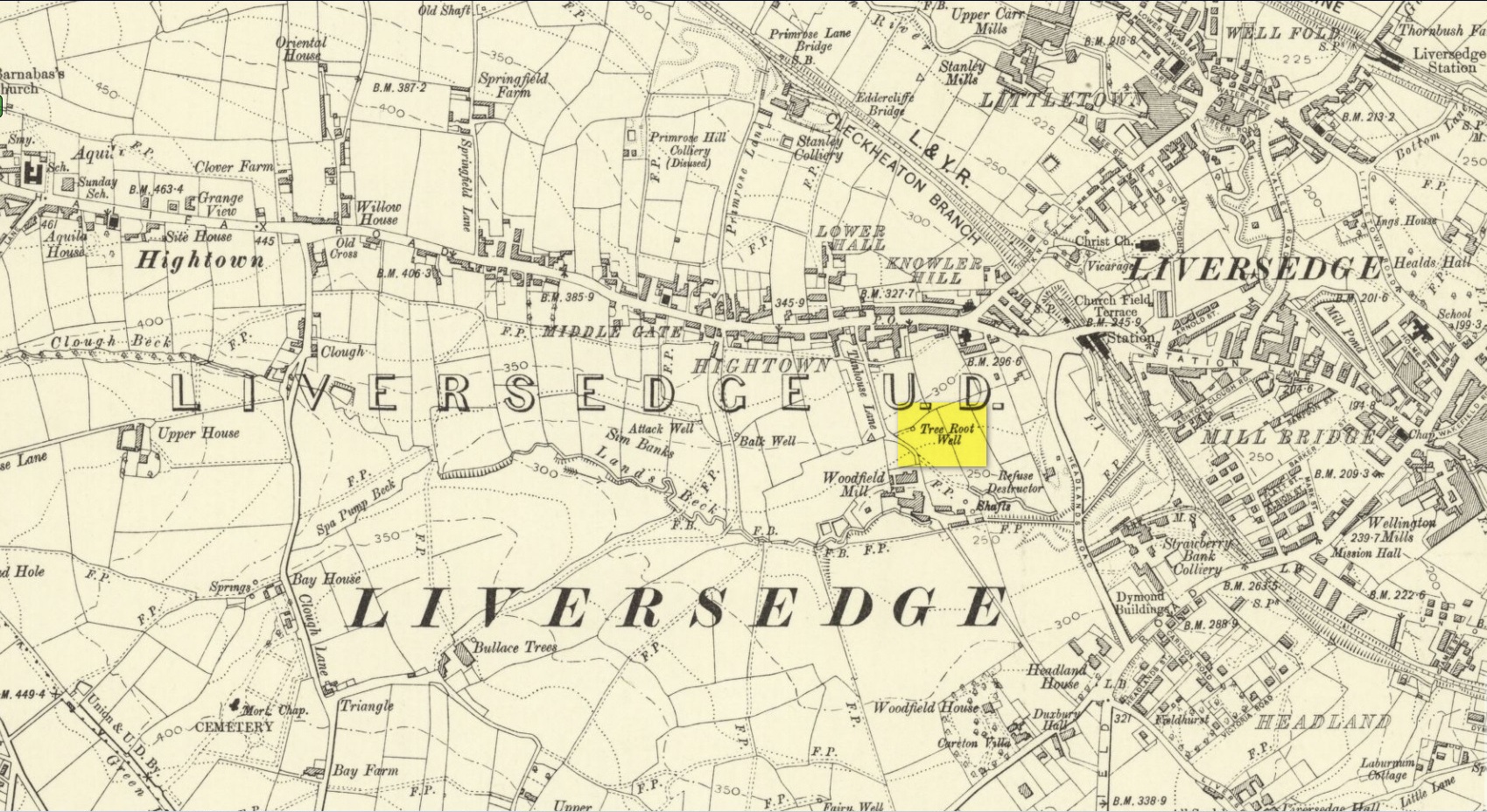
Along with the nearby Attack Well and Balk Well, this was one of three water supplies for the people of Middle Gate between Hightown and Liversdge in the 19th century. Found near the bottom of the old track known as Tanhouse Lane, its waters emerged at the base of some Victorian walling that’s built into the hillside, above which are the decayed remains of what seems to be an old hawthorn tree, whose roots obviously reached down to the stone trough, giving the place its name. Its waters have long since dried up and fallen back to Earth. Although it is shown on the 1908 OS-map of the region, I can find no virtues ascribed to the well nor any local history notes.
Acknowledgements: Huge thanks to the great Gary Ferner, for help in locating the site and the day’s venture!
Cross / Sacred Tree: OS Grid Reference – NN 581 012
Also Known as:
Law Tree
Archaeology & History
As a folklorist and antiquarian, I find this long lost site more than intriguing. Most ancient crosses are stone; but in early centuries many were made from wood which, obviously, have decayed down the years. But this cross, located on the northeast edge of the Lake of Menteith, was actually a tree: a hawthorn no less. This choice would have been made based on it being one of the few trees that are deemed sacred in both christian and indigenous lore. It was described—albeit briefly—in A.F. Hutchison’s (1899) excellent history book of the area:
“The cross of the burgh is said to have been the trunk of an old hawthorn tree, which stood by the lake side, opposite the manse of Port, and was known as ” the law tree.” Around this tree an annual fair was held in the month of September, and called after St. Michael.”
We’re obviously seeing here the traditional animistic veneration of trees by local people, with the incoming christian symbol being grafted onto it. Hawthorns were one of the potent protections against witchcraft and so the handshake between christian and pre-christian systems obviously worked here. Faerie-lore was also rampant at many places for many miles around this site.
References:
Hutchison, Andrew F., The Lake of Menteith – Its Islands and Vicinity, Eneas Mackay: Stirling 1899.
Nothing has previously been written of this site. Its existence came to light during one of umpteen enquiries I’d made with a well-known and very respected local lady, born and bred in Killin (sadly, a dying breed), who is known as a fount of knowledge regarding the history of the area. We were talking about the ancient sites and folklore of the neighbourhood and, amidst being her usual helpful self she asked, “have you been to the Coin Tree? The place where we leave offerings to the spirit of the place?”
I hadn’t.
“No, I’ve never heard of the place.”
“We keep it quiet, ” she said, “for obvious reasons.”
I knew what she meant. The Fairy Tree at Aberfoyle is a case in point: littered with plastic pentagrams, children’s toys and so-called “offerings” of all kinds that have made it little more than a dumping ground for pseudo-pagans and new-age nuts that needs to be cleaned regularly by local folk.
Anyhow, our informant proceeded to give us directions to find the place, going out of the village, but asked that if we were to write about it, to keep its location quiet, “as the place is still used by us”—i.e., old locals. After a slow trek along one of the roads out of the village we saw nothing that stood out. Eventually we came across a fella relaxing in his garden and asked him if he knew anything about an old tree where offerings were made. He gave us that look that olde locals do, to work out whether you’re a tourist or not and, after telling him what we’d been told and who had told us —that seemed to do the trick!
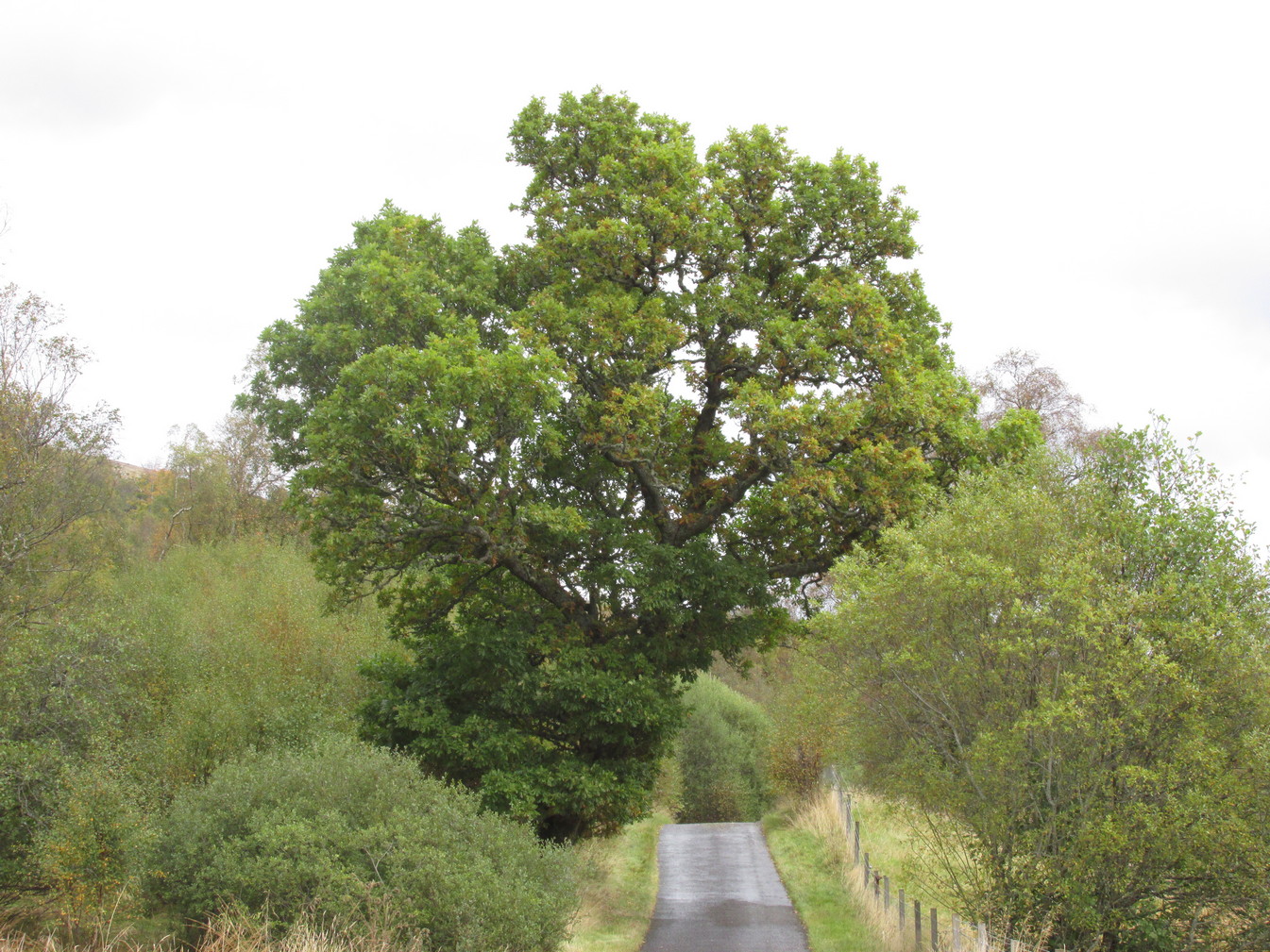
“You’d mean the Fairy Oak I s’ppose? Aye,” he said, “gerrin the car and I’ll drive y’ down to it.”
So we did. A short distance back along the road that we’d come down he stopped and walked along a to large oak tree beside the road. We’d walked straight past it—but in truth it’s not a conspicuous tree and unless you were shown where it was, you’d miss it as easily as we did (and I’m usually damn good at finding such things!). We thanked the fella for taking us to see it and he drove back home to leave us with out thoughts.
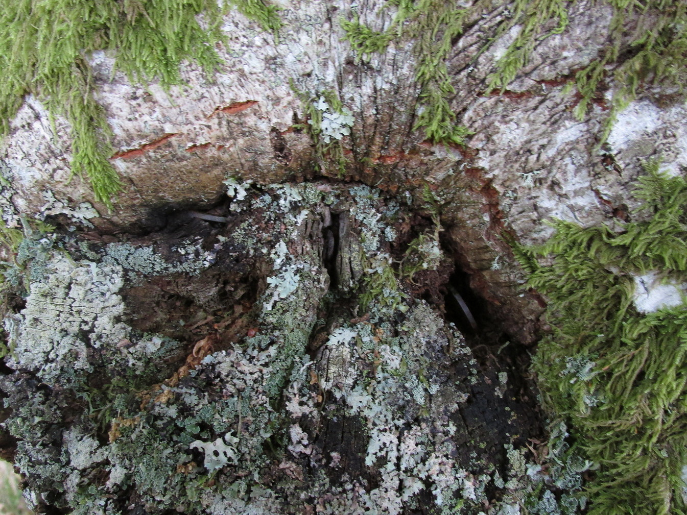
More coins as offerings
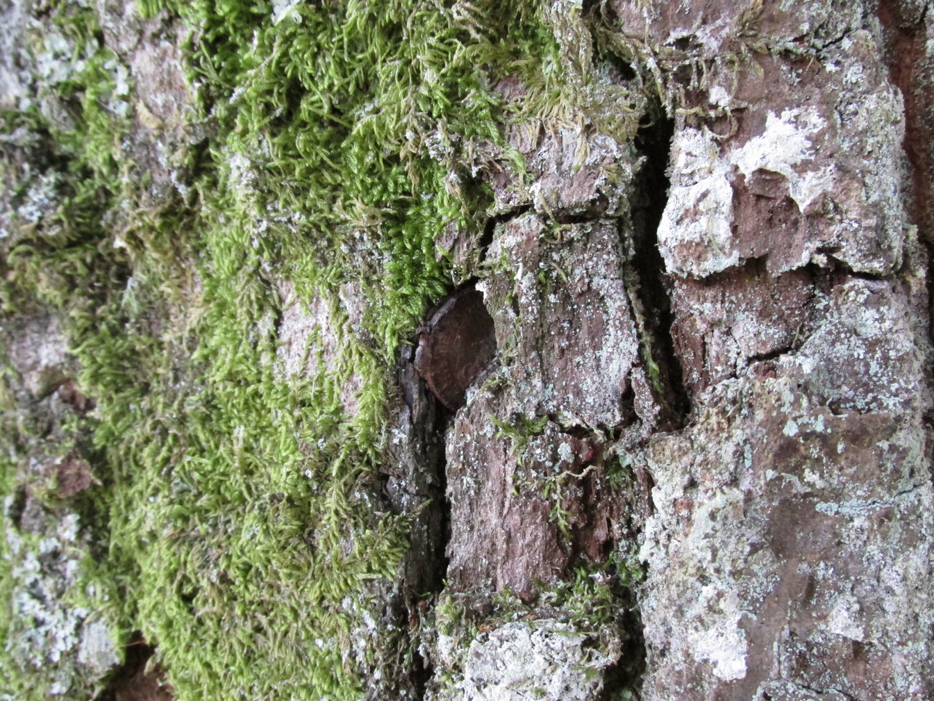
Coins for the little people
Embedded into the tree—some of them barely visible where the bark had grown over them—were clusters of old coins all around its trunk; some of them very old. These had been inserted into the tree as offerings in the hope that the little people, or the genius loci would bring aid to that which was asked of it.
In a field across the road there’s a large “fairy-mound” hillock, or tom as they’re known in the Gaelic landscape: one of Nature’s creations, but just the sort of place where many little people are said to live in many an old folk-tale. Some such mounds are old tumuli, but this aint one of them. It’s possible that it had some relationship with the tree where the fairy folk are said to reside but, if it did, our informants didn’t seem to know.
The important thing to recognise here is that in some of the small villages and hamlet in our mountains, practices and beliefs of a world long lost in suburbia are still alive here and there… But even these are dying out fast, as most incomers have no real attachment to the landscape that surrounds them. Simply put: they see themselves as apart from the landscape as opposed to being a part of it.
This little-known tree, said to have been planted in memory of Sir William Wallace’s mother, is long gone. The only notice I can find of it, is in the writings of Pete Chalmers (1844), who told us:
“There is a tradition that the mother of Sir William Wallace was buried in the old church-yard, on the spot where the present thorn-tree is growing, but how she came to die here history seems to be silent. It is added that her son wished afterwards to erect a monument to her memory, but being in pursuit of, or flight from, his enemies, had not time to do so, and, as a substitute, planted a thorn-tree.”
Much of what constitutes “the old church-yard” has long been covered by the new cathedral and so the precise location of this old thorn tree will never be known, which is a pity, for as Chalmers told,
“This tree had reached an immense size, and was seemingly of great age about 60 years ago (c.1784), when it was blown down by a storm and replaced by a stem from the old tree, now advanced to a considerable height and magnitude—the only living and remaining memorial of the filial affection of the Scottish Patriot.”
Due to a lack of writings from the viewpoint of Wallace and the Scottish people, we are only left with fragments regarding the why’s and wherefores of Wallace and his mum being in Dunfermline. Chalmers thought,
“Possibly the occasion of their being here is referred to in the following lines of the poet, an account of a pretended pilgrimage of Wallace and his mother to St Margaret’s shrine.”
He then cites a more assured account of Sir William being in the area, saying:
“It is recorded of this renowned person, that, on one occasion, in 1808, when he was surrounded by his enemies, he came from the fastnesses where he had taken refuge, to the Forest of Dunfermline, and by the mediation of his friends, proposed, on certain conditions, yiz., the assurance of safety in life, limbs, sad estate, to surrender himself. These conditions were indignantly refused by the haughty and infuriated Edward (the Tosser), who cursed him, by the fiend, for a traitor, and even set a price on his head. On hearing this, the Patriot ” betook himself again to the wilds and mountains, and subsisted on plunder.”
Legendary Tree (lost): OS Grid Reference –TL 96 28
Archaeology & History
In more than twenty volumes about Robin Hood in the Northern Antiquarian library, no mention can be found of this all-but-forgotten site, first recorded (I think) in September 1637, in the boundary perambulation account of northern Colchester. In days of olde, folk walked the boundaries annually and so the description given here follows their very footsteps – although the landscape has obviously been altered in places since then. Because of the length of the entire perambulation their account is rather long, so I’ve cut to the piece relating to our legendary oak tree, which gives a good idea of its location. We meet up with them at a place called Motts-Bridge, just above a place that is today called Seven Arches Farm (TL 9630 2595):
“…and so over Mott’s-bridge, and so cross the river by Nicholas Ayleward’s howse into the meadowe crossinge over to the lower ende of West-fielde, and from thence to Buttolph’s brooke leavinge the Brooke alwais upon the left-hand, and so along to Thomas Abrige (which is righte against Robin Hood’s oake). And from thence to Black-brooke under Chesterwelle and so along the Rampiers by Horkesley Heathe to the brooke that is under Langham-park-corner…”
The description of its whereabouts isn’t too clear, but in a subsequent and much longer perambulation account from August 1671, some extra topographical features are mentioned. Starting not far from Mott’s Bridge, down Shett’s Hill to Newbridge,
“and then into the Fields in the occupation of Matth. Ayleward…through a gate a little above the Bridg: and soe along to Matth. Ayleward’s Yard, crosse the River into Matth. Ayleward’s Meadowe, and crosse that Meadowe into the lower part of Westfields, neare to which is a Foote-bridge cross the river, which is called Mott’s-bridge. And soe along through West-fields to a Gate in a lane at or neere the north ende of a Meadow of one Mrs —, now in Samuel Duglet’s occupation, which lane parts West-fields from Bergholt, as the Parsons of each Parish, whoe were both present, affirmed; and, upon a Tree standing neere to which Gate is set a crosse. And from thence to Butolph’s brooke, leaveing the brooke allwaies upon the left-hand; and soe along through Mr Leming’s Meadows and Woods at the ende of them to a Bridge called Thomas Abridge, leading on to Horkesley Heath, which bridge is right against Robin Hood’s Oake, that stood on the pitch of the hill. And from thence along the Naylande Roade over Horkesley-heathe to Blackbrooke under Chesterwell, which Brooke runnes crosse the way at the foote of Horkesly cawsy…”
This second account seems to speak of the tree in the past tense, telling us that “Robin Hood’s Oake, that stood on the pitch of the hill”, but we can’t be completely sure. I presume that there’s no longer any trace of this legendary oak tree; however, considering the fact that oaks can live to an incredible age, it may be worthwhile for a local antiquarian to follow this ancient boundary and see if, perchance, any remaining tree stump might still be there. Y’ just never know…..
There are several other place-names in Essex relating to our mythical outlaw, including Robinhood End at Finchingfield described in 1699, and a farm of the same name nearby; plus a Robin Hood’s Inn near Loughton. (Reaney 1935) There are probably a few more hiding away in field-name records…
NB:The grid-reference map linked to this site is an approximation. If someone can find the exact spot where the tree stood, we’ll update its position.
References:
Morant, Philip, The History and Antiquities of the Most Ancient Town and Borough of Colchester, W. Bowyer: London 1748.
Reaney, P.H., The Place-Names of Essex, Cambridge University Press 1935.
The tree is at Templeton on the west hand side of the Newtyle to Balkeerie Road travelling north, just before the bend in the road at Templeton Farm.
Archaeology & History
The only written record of the tree is in Strathmore Past and Present by the Reverend J.G. M’Pherson (1885):
Standing Proud
“After driving two miles eastward from the village of Newtyle along a most excellent level road, we enter the united parishes of Eassie and Nevay. The time-honoured boundary-mark is a conspicuous old ash, which popularly goes by the name of the Temple-tree. Tradition cannot guess its age. It is of considerable diameter, but quite hollow from the ground upwards for twenty feet. The bark is stripped off in several parts, and the thin shell of wood exposed is quite worm eaten; here and there being quite worn through, forming a rude door and rugged windows for the weird like interior.
“Large branches spread out, half dead-and-alive, with some foliage, scantily furnished with the life-giving root-sap. Could it speak it would tell of many a strange incident in its vicinity or underneath its arms. Its appearance might almost take one back to the time when the Templars left the neighbourhood; thus fixing its curious appellation”.
Sadly the tree described in the above quotation from 1885 has perished, but, just as it was not growing at the time of the Knights Templars’ local involvement, it is not unreasonable to speculate that it was a daughter of an ash tree that had formed a parish boundary marker of the original estate at the time of the Templars or even before. And now a daughter tree of that venerable 1885 tree grows in its place, the Temple-tree of the present day.
Various writers have attested to the Templar presence in Meigle, indeed M’Pherson writes:
“When the Knight Templars were in pomp…they had considerable interest in Meigle, several lands in the parish still being known as the Temple Lands. We prefer this derivation to the common one of templum, any religious house”.
In describing the now famous Meigle Pictish stones in the New Statistical Account, the Reverend William Ramsay (1845) writes;
“…A more satisfactory account of them has been suggested by Captain T.P. Mitchell, …He considers them as neither more nor less than the monuments of the Knights Templars, who unquestionably had a burying-ground at Meigle”.
While Mitchell was wrong in his attribution of the carved stones, he was clearly aware of the continuing memory of the Templars.
Modern research has shown that many of the Templar estates and lands in Scotland remained as separate fiscal entities within the Hospitaller lands up until at least the Reformation, which may explain the enduring Templar nomination of our tree.
Note: The tree formed the 19th century boundary of the parishes of Eassie and Nevay to the north, and Newtyle, both in Angus. We must assume the Templar lands boundary has been incorporated into the later parish system.
Note: This is not a clooty tree – please treat her with respect.
References:
Rev William Ramsay, Parish of Alyth, The New Statistical Account of Scotland, 1845.
Rev J.G. M’Pherson, Strathmore Past and Present, S. Cowan & Co: Perth, 1885.
Robert Ferguson, The Knights Templar And Scotland, The History Press: Stroud 2010
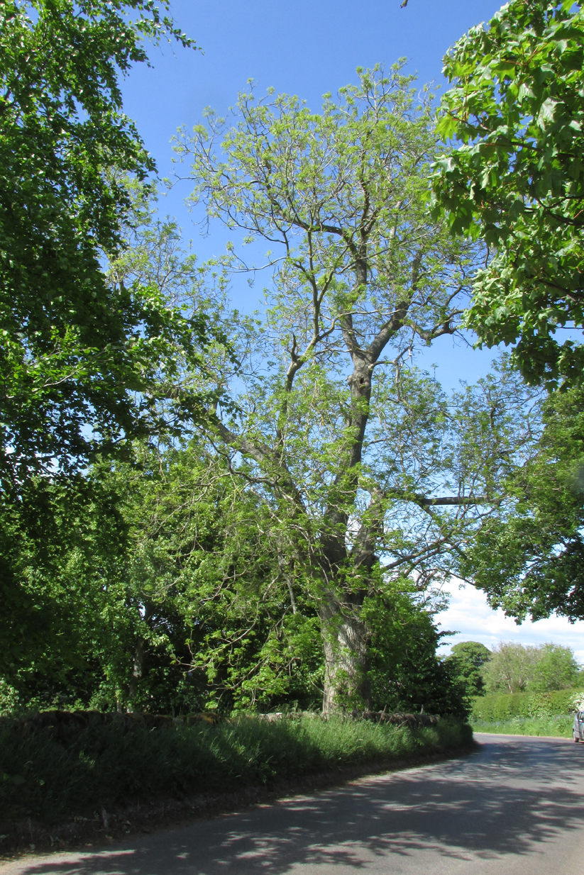
Once visible near the middle of the village, references to this local water supply seem pretty scant. According to Kenneth Cameron (1950) it gained its name from a local man called Robert Holland. This may be the case; but there is a curious entry found in a notice regarding the Land Enclosures of Smalley from November 6, 1784. In it we read that the land here was at that time owned by one Samuel Kerry (well known in the village as he built The Rose and Crown pub in 1768) who was living “upon the Common” and had “part of a croft” here. Therein was mentioned a water source named the ‘Holly Well’ instead of the Holland Well. I can only assume that the two are the same, as the proximity of them are very close indeed. The account told that,
“a disused well in the triangular croft at the back of the sixth milestone in the village marks the site of (Samuel Kerry’s) original home, and he is said to have dug the “Holly Well” close by for brewing purposes, which has long supplied the vicinity with good water.”
The name ‘Holly’ may infer that a holly tree grew by the side of the well, and that the title ‘Holland’ was a corruption later grafted onto the site. Are there any local historians out there who know more…?
References:
Cameron, Kenneth, The Place-Names of Derbyshire – volume 2, Cambridge University Press 1950.
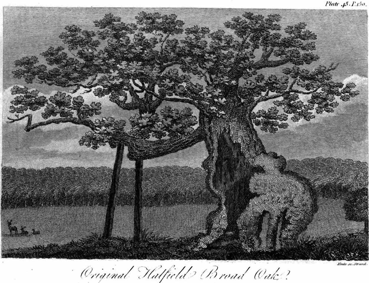
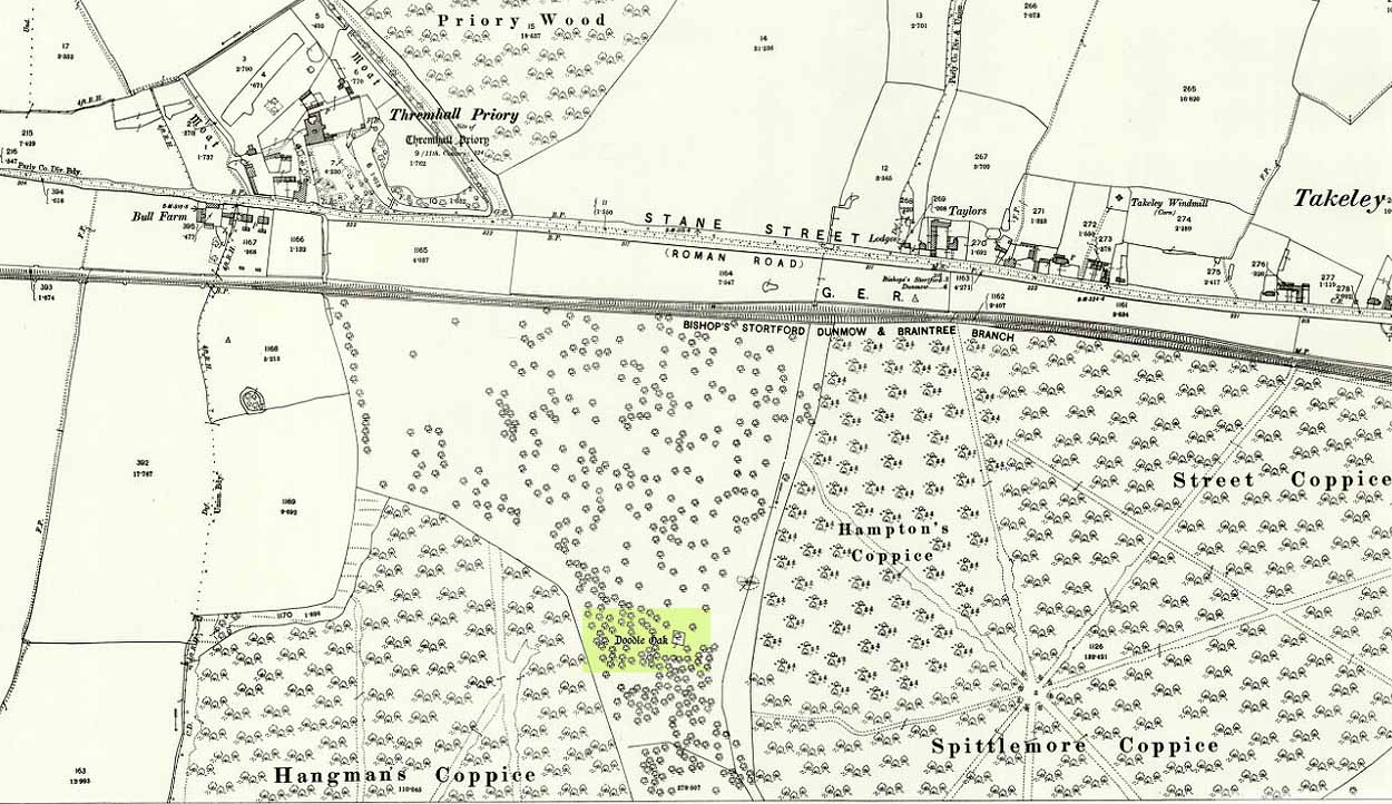
Erroneously ascribed by the reverend Winsland (1952) as being the ‘Doodle Oak’, the ancient and giant tree called the Broad Oak was, as records show, always known by this name, but was subsequently replaced by another after its demise. It was this second tree that became known as the Doodle Oak. Winsland described it as “an immense and famous oak tree”, under whose “spreading branches in olden days the Lord of the Manor probably held his court and dispensed justice.”
The tree was described as early as 1136 AD and was probably an early tribal meeting site, or moot spot. In Philip Morant’s (1763) work, he described it as,
“A tree of extraordinary bigness. There has been another since…called Doodle Oak.”
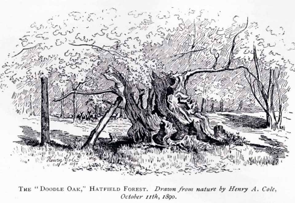
The old Oak in 1890
The Doodle Oak was thought to date from around 10-11th century and its predecessor may have been upwards of a thousand years old before this one took its place. In 1949, one patient botanist, Maynard Greville, investigated the Doodle Oak tree-rings and found it to be 850 years old. Other estimates suggest it was a hundred years older than that! Whichever was the correct one, a measurement of its trunk found it to be some 19 yards in circumference – one of the largest trees ever recorded in Britain!
Sketches of its dying body were thankfully made near the beginning and the end of the 19th century: one in Mr Vancouver’s (1807) Agriculture of Essex, and the other by Henry Cole of the Essex Naturalist journal.
Doodle Oak on 1896 map
Some speculate that the Broad Oak of ancient times and the subsequent Doodle Oak were at very different places in the parish, but without hard evidence this idea is purely hypothetical. And whilst the name ‘broad’ oak is easily explained, the name ‘doodle’ is slightly more troublesome. However, a seemingly likely etymology is found in the Essex dialect word dool, which Edward Gepp (1920) told,
“seems to mean, (1) a landmark; (2) a path between plots in a common field.”
The former of the two would seem to be the most likely. This is echoed to a greater degree in Wright’s (1900) magnum opus, where he found the dialect word dool all over the southeast, meaning,
“a boundary mark in an unenclosed field.”
Giant trees on ancient boundaries, like the Broad Oak of earlier times, would seem to be the most probable reason for its name. Today, all that’s left of the site is a small plaque on a small tree-stump, telling us what once stood here…
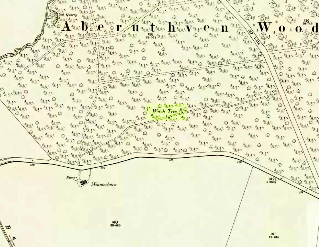
Just off the A9 between Stirling and Perth is Aberuthven village. Down the Main Street and just south of the village, turn west along Mennieburn Road. A half-mile on, just past Ballielands farm, you reach the woods. Keep along the road for another half-mile, close to where the trees end and go through the gate where all the rocks are piled. Walk up to the tree-line 50 yards away and follow it along the line of the fence east, til it turns down the slope. Naathen – over the barbed fence here, close to the corner, about 10 yards in, is the tree in question…
Archaeology & History
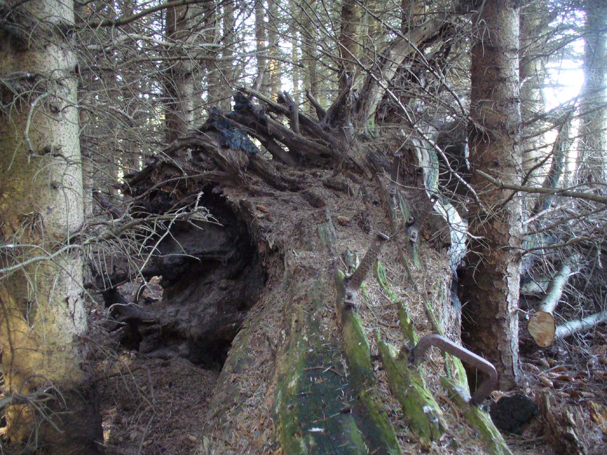
Looking along the fallen trunk
Laid down on the peaty earth, fallen perhaps fifty years ago or more, are the dying remains of this all-but forgotten Witch Tree. To those of you who may strive to locate it—amidst the dense eye-poking branches of the surrounding Pinus monoculture—the curious feature on this dying tree are a number of old iron steps or pegs, from just above the large upturned roots. About a dozen of them were hammered into the trunk some 100 years or more ago and, were it to stand upright again, reach perhaps 30 feet high or more. These iron pegs give the impression of them being used to help someone climb the tree when it was upright; but their position on the trunk and the small distance between some of them shows that this was not their intention. Their purpose on the tree is a puzzle to us (does anyone have any ideas?).
Embedded iron from the roots
Embedded iron 30-40ft along
The fallen trunk has broken into two main sections, each with iron pegs in them. The very top of the tree has almost completely been eaten back into the Earth. Unfortunately too, all the bark has completely rotted away and so identifying the species of the tree is difficult (though I’m sure there are some hardcore botanists out there who’d be able to enlighten us). The possibility that the early map-reference related to a Wych-elm (Ulmus glabra) cannot be discounted, although this would be most unusual for Ordnance officers to mistake such a tree species with a ‘witch’. Local dialect, of course, may have been a contributing factor; but in Wilson’s (1915) detailed analysis of the regional dialect of this very area, “wych elm” for witches does not occur. Added to this is the fact that the indigenous woodland that remains here is an almost glowing birchwood (Betula pendula) in which profusions of the shaman’s plant, Amanita muscaria, exceed. There were no wych elms hereby.
The tree was noted by the Ordnance Survey team in 1899 and was published on their maps two years later, but we know nothing more about it. Hence, we publish it here in the hope that someone might be able top throw some light on this historical site.
Folklore
Halfway along the fallen tree
We can find nothing specific to the tree; but all around the area there are a plethora of tales relating to witches (Hunter 1896; Reid 1899)—some with supposedly ‘factual’ written accounts (though much of them are make-believe projections of a very corrupt Church), whilst others are oral traditions with more realistic tendencies as they are rich in animistic content. One of them talks of the great mythical witch called Kate McNiven, generally of Monzie, nearly 8 miles northwest of here. She came to possess a magickal ring which ended up being handed to the owners of Aberuthven House, not far from the Witch Tree, as their associates had tried to save her from the crazies in the Church. This may have been one of the places where she and other witches met in bygone centuries, to avoid the psychiatric prying eyes of christendom.
Until the emergence of the Industrialists, trees possessed a truly fascinating and important history, integral to that of humans: not as ‘commodities’ in the modern depersonalized religion of Economics, but (amongst other things) as moot points—gathering places where tribal meetings, council meetings and courts were held. (Gomme 1880) The practice occurred all over the world and trees were understood as living creatures, sacred and an integral part of society. The Witch Tree of Aberuthven may have been just such a site—where the local farmers, peasants, wise women and village people held their traditional gatherings and rites. It is now all but gone…
Legendary Trees (lost): OS Grid Reference – NN 693 242
Folklore
A fascinating story of this forgotten site is detailed in Alex Porteous’ (1912) history book on this tiny parish at the eastern end of Loch Earn. It’s a peculiar tale—and unless the story was little more than the local people ripping the piss out of the patronising incomers, its nature remains a mystery. Porteous wrote:
“What were known as the Goose Oaks grew by the loch-side about two or three hundred yards west from the hotel. The story is told of a celebrated goose which attained to the great age of 160 years and finally gave up this life in 1818. It is solemnly averred by Mr (John) Brown that the history of this goose was well authenticated and that the families and individuals who successively were owners of the goose were highly respectable, and that its history was preserved entire for the period back to 1658, while he naively adds—”How long it was in being prior to that date is uncertain.” The goose was buried at the spot indicated, and the oaks trees, two in number, of which only one remains now, planted over its grave; but the story, as regards the age, must be looked upon as apocryphal.”
One wonders what on Earth Sir James Frazer might have made of this tale!