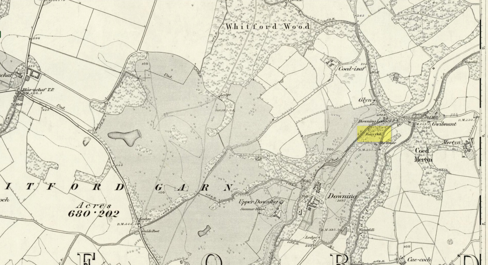
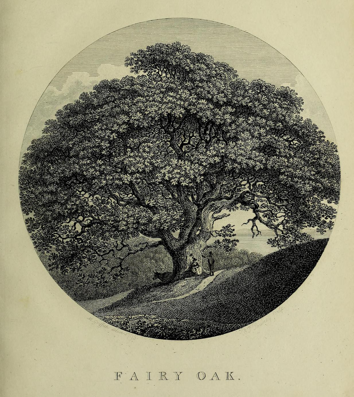
Highlighted on the earliest Ordnance Survey map of the region in 1878 and described much earlier by Thomas Pennant (1796)—almost as legendary as the fairies themselves in some parts—this ancient tree was obviously a place of great repute in the mythic history of the people in previous centuries. Animistic relationships with the landscape were still deeply embedded in the daily lives of our peasant communities all across the country when Pennant wrote about this place. In his antiquarian history of the area he described the great mansion of Downing Hall and in its grounds the ruins of Molandina Abbey. “Above this,” he wrote,
Fairy Oak on the 1878 mapPennant’s 1796 drawing
“is a spreading oak of great antiquity, size, and extent of branches: it has got the name of the Fairy Oak. In this very century a poor cottager, who lived near the spot, had a child who grew uncommonly peevish; the parents attributed this to the fairy, and imagined that it was a changeling. They took the child, put it in a cradle, and left it all night beneath the tree, in hopes that the tylwydd têg, or fairy family, or the fairy folk, would restore their own before morning. When morning came they found the child perfectly quiet, so went away with it, quite confirmed in their belief.”
Nearby, and in the same grounds of the mansion, Pennant told there to be an even older and greater oak tree that “has in it furrows so deep, and of aspect so uncommonly venerable, as to render its shade as worthy of the solemn rites of the Druids.”
References:
Pennant, Thomas, The History of the Parishes of Whiteford and Holywell, B. & J. White: London 1796.
Cup-Marked Stone (lost): OS Grid Reference – SO 1491 0045
Archaeology & History
Sometime in the 1940s, a certain Lady A. Fox recorded a cup-marked stone “in the vicinity of Pen-twyn” near Bargoed. Its position in the landscape is a good one: on a geological promontory and overlooking the valley below. The find was indexed by the Ordnance Survey, but apart from it’s grid-reference, all attempts to locate the design have so far proved unsuccessful.
It was mentioned briefly in the Royal Commission (1976) survey of Glamorgan, then subsequently listed in the surveys of Sharkey (2004) and Nash (2007), but none of them were able to locate it. And hence, I post it here, in the hope that some local hunter will be able to recover it from its hiding place!
References:
Mazel, A., Nash, G. & Waddington, C. (eds.), Art as Metaphor: The Prehistoric Rock Art of Britain, ArchaeoPress: Oxford 2007.
Nash, George, “A Scattering of Images: the Rock Art of Southern Britain,” in Art as Metaphor, ArchaeoPress: Oxford 2007.
Royal Commission on the Ancient & Historical Monuments, Wales, An Inventory of the Ancient Monuments in Glamorgan – Volume 1: Pre-Norman, Part 1: The Stone and Bronze Ages, HMSO: Cardiff 1976.
Sharkey, John, The Meeting of the Tracks: Rock Art in Ancient Wales, Gwasg Carreg Gwalch: Llanrwst 2004.
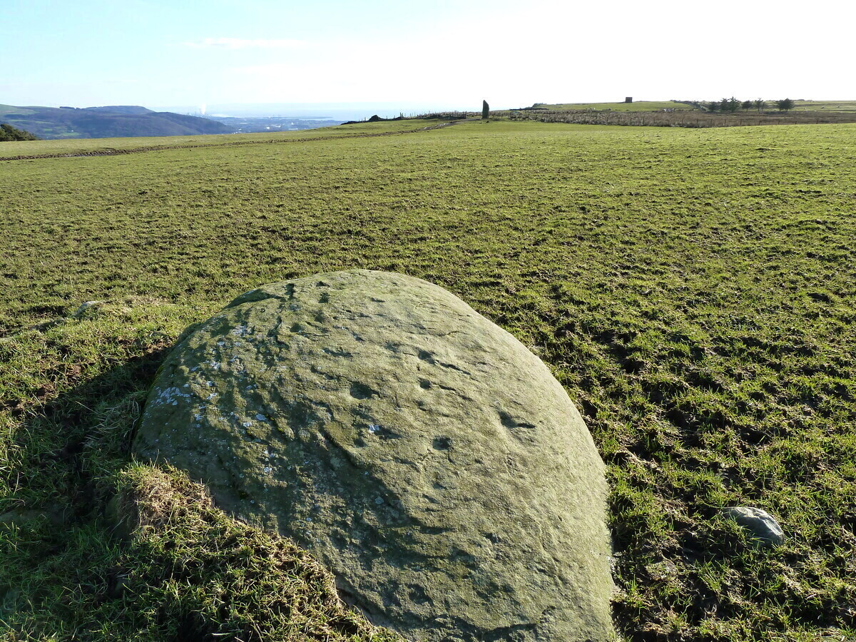
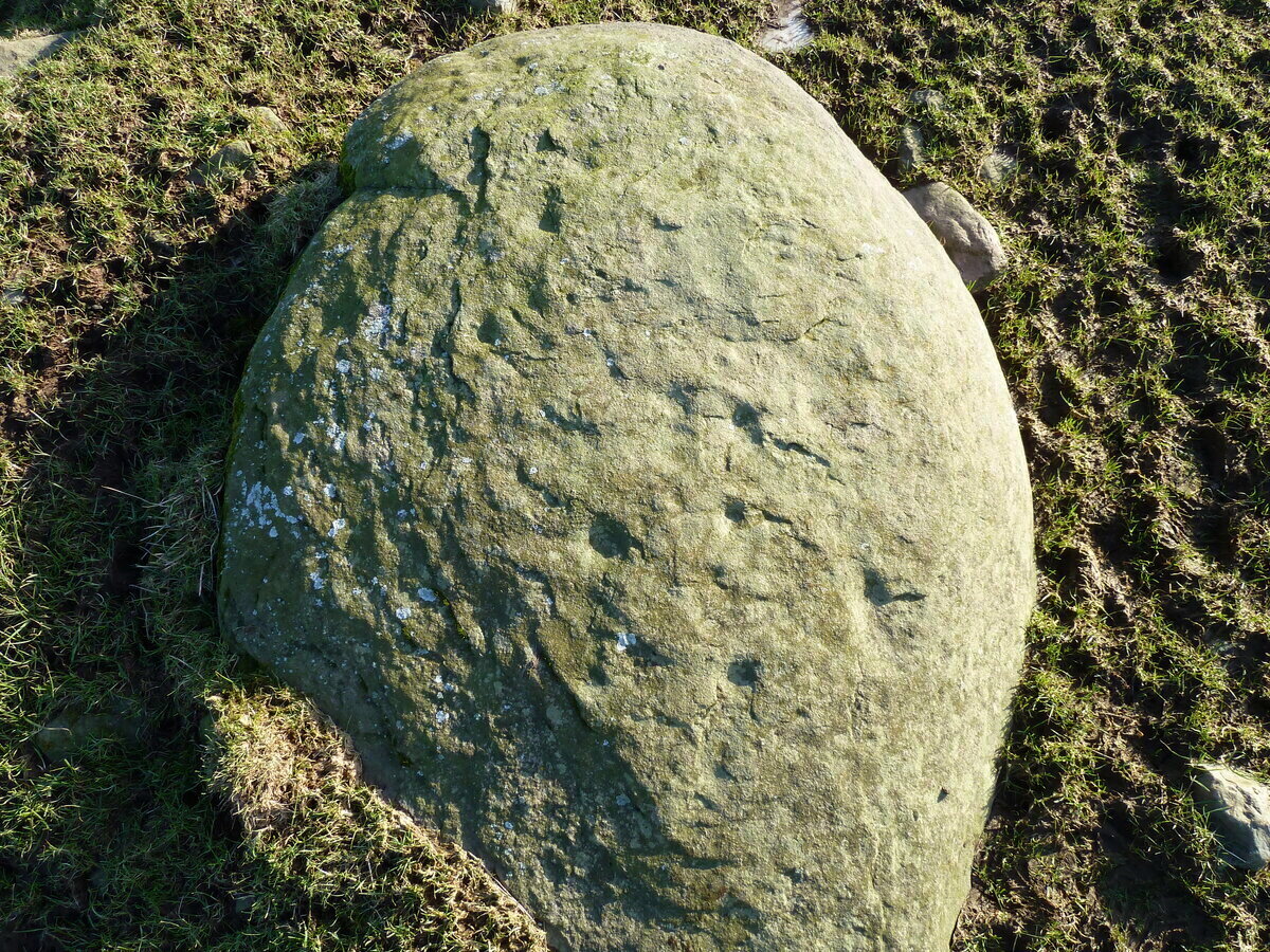
An interesting new cup-marked stone found by Paul Blades is this smooth rounded (female) stone that may originally have had some relationship with the tall standing stone of Careg Bica 160 yards to the south. Around ten cup-marks are etched onto its surface, in a seemingly random arrangement (as usual!). Although it seems to be an isolated carving, it’s likely that others will exist in the area.
Carving & outlying monolithCareg Bica petroglyph
The direction and proximity of the standing stone may have had some relationship with the carving. In traditional northern hemisphere societies, the cardinal direction North is generally associated with darkness and death, primarily due to the fact that this is the area in the heavens where neither sun or moon ever appear; whilst South relates to life and positive natural associations due to it being the high point of the sun during the day. This animistic attribute existed till recently in the water-lore of northern England and Scotland where “south-running streams bore a high repute.” Whilst such mythic attributes are well established, any cardinal relationship here is purely speculative.
Acknowledgements: Huge thanks to Paul Blades for use of his photos in this site profile – and of course for finding the stone!
Stone Circle (destroyed): OS Grid Reference – SM 8615 1428
Archaeology & History
Described in context with an extant standing stone 100 yards to the north, this stone circle seems to have been destroyed in the latter half of the 19th century. It was described in the Royal Commission’s huge Pembrokeshire (1925) survey, after they had visited the site and viewed the remains. They told us:
“On the side of the road immediately opposite to Cliff Cottage, and constituting part of the garden walls of Upper Lodge, are numerous boulders which formed a well-defined stone circle. A few years ago they were moved, dressed, and used for walling. The entrance to the circle is said to have faced north-east. The southern portion was still visible about the year 1896.”
As far as I’m aware, local people report that a couple of the stones are still visible in the overgrown walling. Students working for the Welsh Coflein database allege that the remaining stones “are of doubtful antiquity.” Unless they have some substantial evidence to validate this statement (none is given) their remarks should be taken with a pinch of salt.
References:
Royal Commission Ancient & Historical Monuments, Wales, An Inventory of the Ancient Monuments in Wales & Monmouthshire: VII – County of Pembroke, HMSO: London 1925.
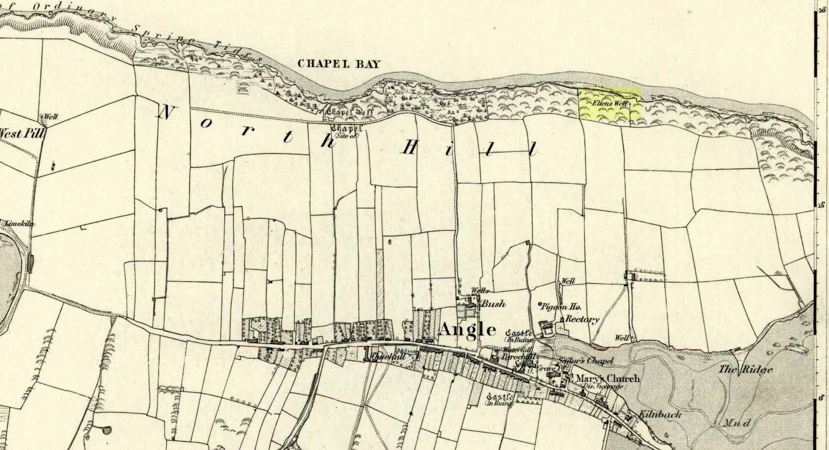
Very little seems to be known about this apparently lost site, deemed to be an authentic holy well in Francis Jones’ (1954) fine survey: the ‘Ellen’ in question here being the legendary St Helen. It was highlighted on the first OS-map of the area in 1869 and subsequently included in the Royal Commission’s huge Pembrokeshire (1925) tome, but when they came to visit the site they reported that “it could not be traced, nor any information obtained about it.” Has it truly fallen back to Earth, or do any local historians and antiquarians know where it is…?
References:
Jones, Francis, The Holy Wells of Wales, University of Wales 1954.
Royal Commission Ancient & Historical Monuments, Wales, An Inventory of the Ancient Monuments in Wales & Monmouthshire: VII – County of Pembroke, HMSO: London 1925.
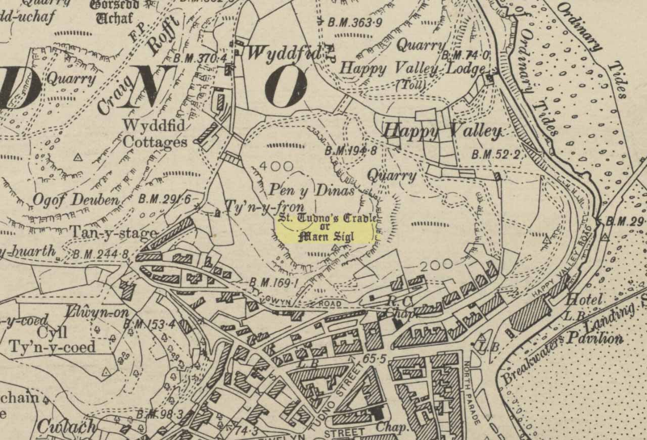
Highlighted on the 1901 OS-map of the area, this old rocking stone was located on the heights of Pen y Filas above Llandudno. Originally a site of heathen worship—the druids, it is said—the site was later patronised by the Irish saint, Tudno: a hermit who lived in a cave (Ogof Llech) a mile to the northwest, on the heights of the legend-filled Great Orme.
Rocking stones are well-known as geo-oracular forms (stone oracles) in folklore texts across the country, although they’re almost entirely rejected by historians as little more than ‘curiousities’ and meaningless geological formations. In olde cultures elsewhere in the world however, stones like this were always held in reverence by traditional people – much as they would have done in Wales and elsewhere in Britain.
References:
Hughes, Arthur R., The Great Orme: Its History and Traditions, R.E. Jones: Conway n.d. (c. 1950)
Jones, H. Clayton, “Welsh Place-Names in Llandudno and District” in Mountain Skylines and Place-Names in Llandudno and District, Modern Etchings: Llandudno n.d. (c.1950)
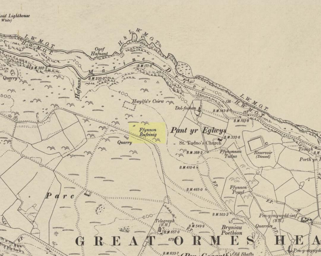
To be found on the legend-filled landscape known as the ‘Great Orme’, this ancient well was highlighted on the 1901 OS-map of the region, on the south side of the track. Sadly, despite an occasional puddle that fills the old trough when She rains, its waters are no longer running. H.C. Jones (n.d.) informed us that this was a ‘Roman Well’, which tradition said was a place they used when they invaded this part of Wales, although Paul Davies (2003) thought this “to be wishful thinking”.
Despite this, in recent years the walling around the well has been rebuilt by the track-side and a stone plaque with the words ‘Roman Well’ has been mounted to tell you that you’re at the right place.
References:
Davies, Paul, Sacred Springs, Blorenge: Llanfoist 2003.
Jones, H. Clayton, “Welsh Place-Names in Llandudno and District” in Mountain Skylines and Place-Names in Llandudno and District, Modern Etchings: Llandudno n.d. (c.1950)
This once important healing stone that was moved a short distance (from grid reference SN 1775 1875 to SN 1770 1874 according to officials) to its present spot, around 1925, whilst having a long history according to the folk traditions of Carmarthenshire, was previously questioned as an authentic site by none other than Prof John Rhys (1875), following his visit to the site in the 1870s. Although Rhys seemed an isolated voice, some modern archaeologists have also questioned its veracity. It’s difficult to say precisely what the original nature of the stone may have been, but it was certainly accommodated in medieval times as a healing stone and used in conjunction with a pagan well – which was of course, accommodated by the Church. If the stone itself had a megalithic pedigree, as some have believed, we know not what it may have been…
As Janet & Colin Bord (2006) wrote, the stone “still survives, but to the casual observer it looks like any other abandoned block of stone,” sitting innocuously within the ring of trees surrounding the church. An early account of the stone was written by E.L. Barnwell (1872), who told:
“The present church of Llangan in Carmarthenshire is a wretched structure, built in 1820, and is about to be removed, as the population has long since migrated to some distance from it, and in a few years even the memory of Canna’s church having once existed here may cease. There is, however, a relic still left, which we trust will not be overlooked by the local authorities, as indeed it seems to have been hitherto ; for no notice occurs of it in the account of the parish in Lewis’s Topographical Dictionary or any other work. This relic is a rude stone, forming a kind of chair, lying in a field adjoining the churchyard, and about thirty or forty yards from it. When it was removed to its present position is unknown. There was also a well below the church called Ffynnon Canna; and there is still a small brook available, if required, for following the rules prescribed to those who wish to avail themselves of the curative powers of the saint’s chair. It appears that the principal maladies which are thus supposed to be cured are ague and intestinal complaints. The prescribed practice was as follows. The patient first threw some pins into the well, a common practice in many other parts of Wales, where wells are still thought to be invested with certain powers. Then he drank a fixed quantity of the water, and sometimes bathed in the well, for the bath was not always resorted to. The third step was to sit down in the chair for a certain length of time; and if the patient could manage to sleep under these circumstances, the curative effects of the operation were considerably increased. This process was continued for some days, even for a fortnight or longer. A man aged seventy-eight, still living near the spot, remembers the well and hundreds of pins in it, as well as patients undergoing the treatment; but, about thirty or thirty- five years ago, the tenant carried off the soil between the well and the watercourse, so as to make the spring level with the well, which soon after partly disappeared, and from that time the medical reputation of the saint and her chair has gradually faded away, and will, in the course of a generation or two, be altogether forgotten.”
Folklore
In Wirt Sykes (1880) classic text, he told us that the field where the original Canna’s Chair may have been, possessed fairy-lore that we find at other sites, usually ascribed as prehistoric. He wrote:
“In the middle of this parish there is a field called Parc y Fonwent, or the churchyard field, where, according to local tradition, the church was to have been originally built; but the stones brought to the spot during the day were at night removed by invisible hands to the site of the present church. Watchers in the dark heard the goblins engaged in this work and pronouncing in clear and correct Welsh these words, “Llangan, dyma’r fan,” which means, “Llangan, here is the spot.””
References:
Allen, J. Romilly, The Monumental History of the Early British Church, SPCK: London 1889.
Baring-Gould, S. & Fisher, John, Lives of the British Saints – volume 2, London 1907.
Cup-Marked Stone (lost): OS Grid Reference – ST 260 870
Archaeology & History
Rhiwderin cup-marks
This fine-looking cup-marked stone was uncovered during a botanical outing in the last decade of the 19th century. Described as being around the township of Rhiwderin, the exact whereabouts of the carving is unknown and it’s not been seen since the first description of it in an early edition of Archaeologia Cambrensis by Mr T.H. Thomas. (1895) John Sharkey (2004) mentioned the site in his recent survey of Welsh rock art, saying simply “location unknown.”
The missing Rhiwderin stone
Although we know there are no hard and fast rules for working out the location of cup-and-ring markings, one may be fortuitous in exploring any nearby Bronze Age or neolithic tombs (cairns, tumuli, etc) in the Rhiwderin district, as they do tend to enjoy the company of such sites — but I must stress, this is by no means a dead cert!
Mr Thomas’s description of the carving was as follows:
“I enclose a sketch of what seems to be a cup-marked stone which I observed yesterday near Rhiwderin, Monmouth. Unless there be some operation which simulates such markings with which I am unacquainted, I take the specimen to add an instance of these mysterious prehistoric remains to the very short list given for Wales by Mr. Romilly Allen, and to be the first reported for South Wales.
“The stone displaying the cup-markings is a mass of millstone grit, earth-fast, the slanting surface appearing above the turf being about a yard wide, and 4 feet long. Upon the upper half of the surface is a group of twelve cups from 1½ to 2in diameter, and about 1in deep. On first noticing the cups they were taken for holes out of which quartz pebbles, abundant in the local millstone grit, had been weathered, but examination of the block showed that no pebbles of large size exist, or had existed in it, and the conclusion was arrived at that the cups are artificial.
“On turning back some of the turf covering the base of the slope of the stone, no other cups were discovered.
“The stone lies within an old enclosure, as shown by wild apple-trees and an abundance of daffodils, and still more clearly by ruins, which seem those of a cottage or small farm near by. This contiguity to a habitation which does not seem to have been abandoned more than a century, made me suspect some medieval or more recent origin for the markings. I cannot, however, account for them otherwise than by supposing them to be cup-markings in the technical archaeological sense.
“The stone was observed while in the company of Dr C.T. Vachell of Cardiff, searching for varieties of narcissus which occur at several points in the neighbourhood…”
If anyone comes across this lost carving, please let us know!
References:
Sharkey, John, The Meeting of the Tracks: Rock Art in Ancient Wales, Gwasg Carreg Gwalch: Llanrwst 2004.
Thomas, T.H., ‘Archaeological Notes and Queries,’ in Archaeologia Cambrensis, volume 12 (5th series), 1895.
From the Denbigh road (A543 and A544) turn off at Llansannan for Gwytherin on the B5384 for 6 miles or so. At the village of Gwytherin St Winifred’s church stands roughly in the middle of the place at a junction of four roads. The church stands upon a small round hill and within the confines of the churchyard (north side) are four small standing stones – you can’t really miss them!
Archaeology & History
At the northern side of the churchyard near the wall there’s an alignment of four small standing stones probably dating from the Bronze Age. The stones stand roughly 3 metres or 6 feet apart and are about 1 metre or 3 feet in height. The westernmost stone has a Latin inscription carved onto it which is ‘VINNEMAGLI FILI SENEMAGLI’, or, ‘The Stone of Vinnemaglus, son of Senemaglus’, which is generally thought to date from the Romano-British period in the 5th-6th century AD and to be a grave marker. Most probably the inscription was carved onto the prehistoric stone during the early Christian period — the stones themselves being from pre-Christian times.
The general thinking is that these stones belonged to a Bronze Age settlement that stood here long before any church was founded. Perhaps there were other stones here forming a linear alignment that must have meant something to the ancient folks who lived here. There has also been speculation as to whether the inscribed standing stone could actually mark the grave of St Winifred herself.
The churchyard is circular, indicating that it is a pagan sacred site. Celtic churches being built on sites like this to Christianize them, but not entirely forget the meaning to the peoples of “the old religion,” as it’s called. Also in the churchyard stand three ancient yew trees — yet another sign that the site is a holy one.
The first church in Gwytherin was founded by St Eleri (Elerius), a Welsh prince, in the mid-7th century. He may be identical with St Hilary, a saint commemorated at a village of that name near Cowbridge, South Glamorgan. Other than that, Eleri and his mother, Theonia, founded a double monastery here: one for men and the other for women, to which a young St Winifred (of Holywell) came to and was elected second abbess after Theonia. St Eleri was probably a disciple of St Beuno, uncle to St Winifred, and also her cousin. Here in 650 or 670 AD Winifred was buried in the churchyard — her relics being taken to Shrewsbury abbey in 1138.
References:
Burl, Aubrey, From Carnac to Callanish, Yale University Press 1993.
Houlder, Christopher, Wales: An Archaeological Guide, Faber & Faber: London 1978.
Hulse, T.G., Gwytherin: A Welsh Cult Site Of The Mid-Twelth Century, (unpublished paper) 1994.
Nash-Williams, V.E., The Early Christian Monuments of Wales, Cardiff, 1950.
Westwood, J.O., “Early Inscribed Stones of Wales,” in Archaeologia Cambrensis, 18:255-259, 1863.