Monzie (3), Bridge of Tilt, Blair Atholl, Perthshire

Cup-Marked Stone:  OS Grid Reference – NN 90553 67894

Getting Here

Monzie (3) stone, in situ

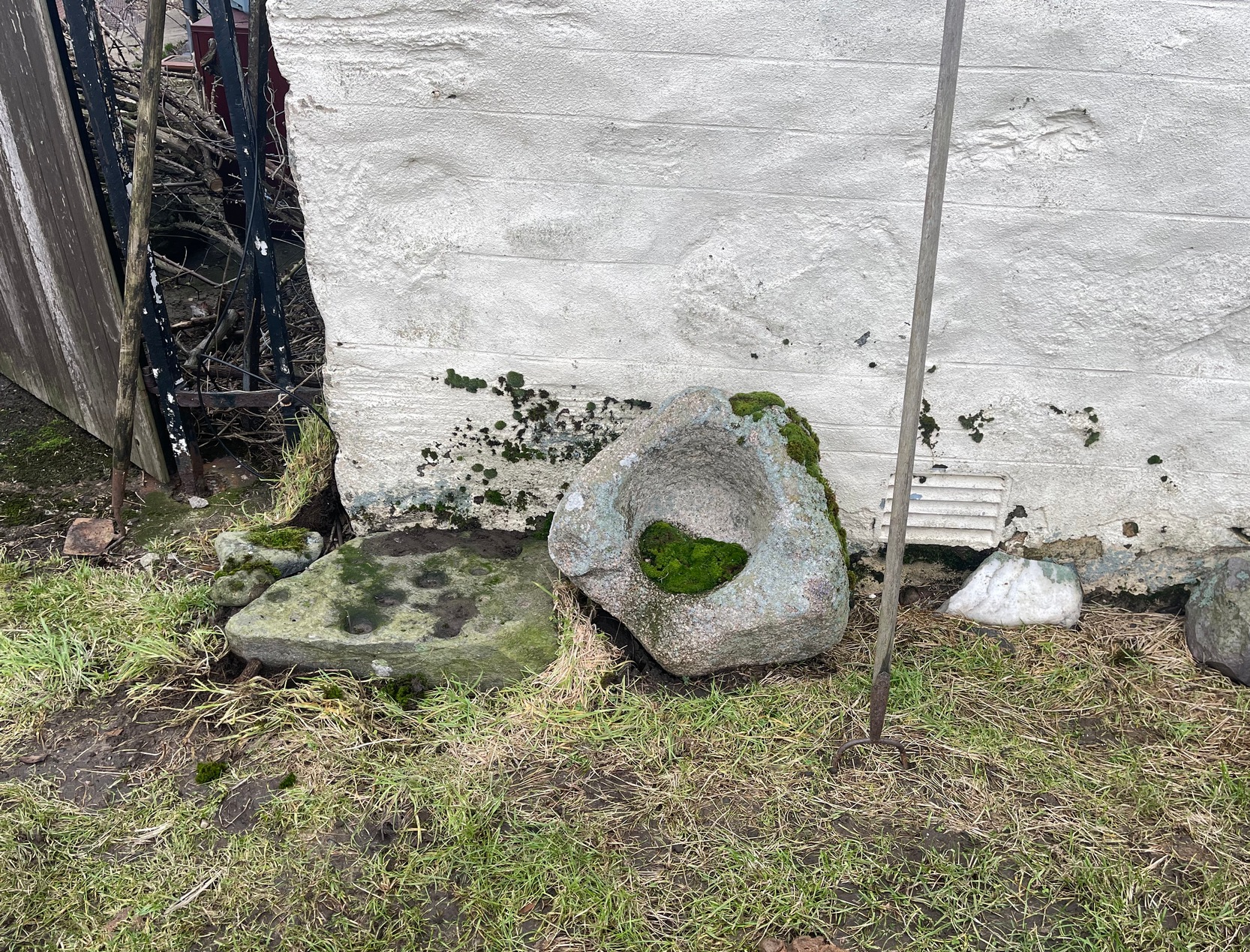
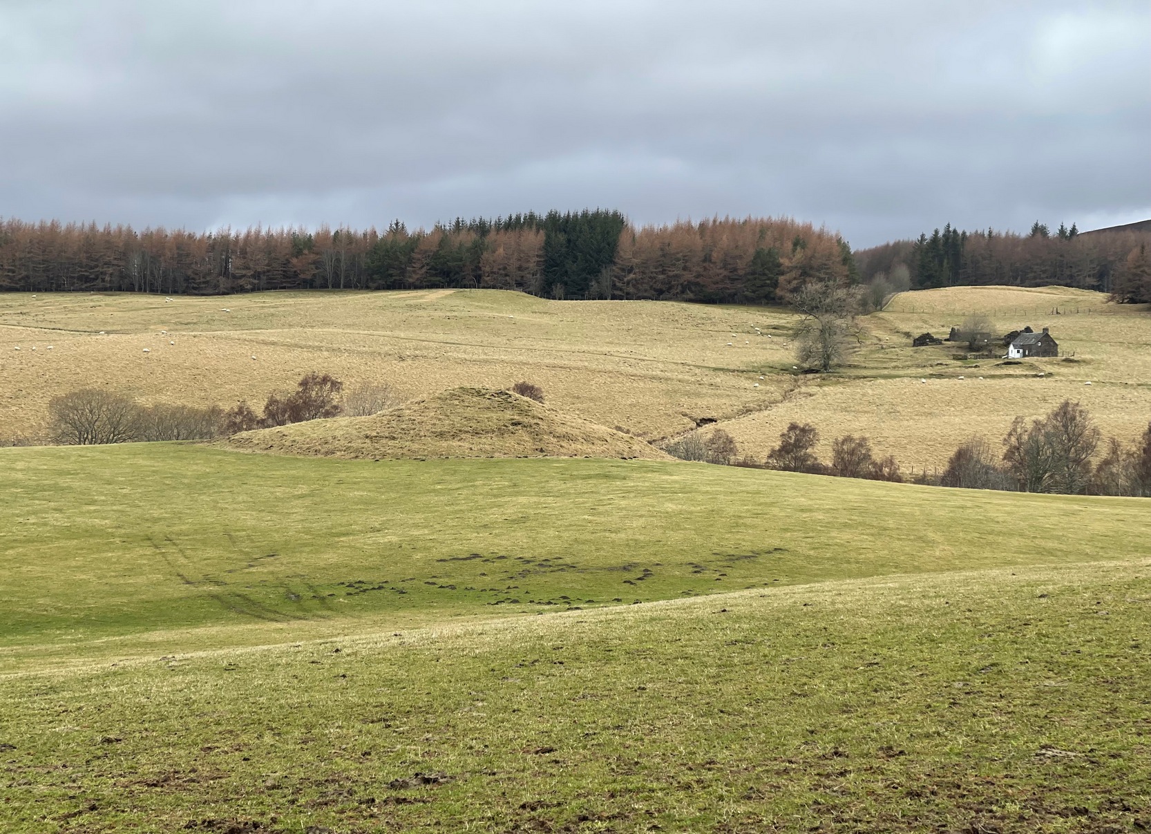
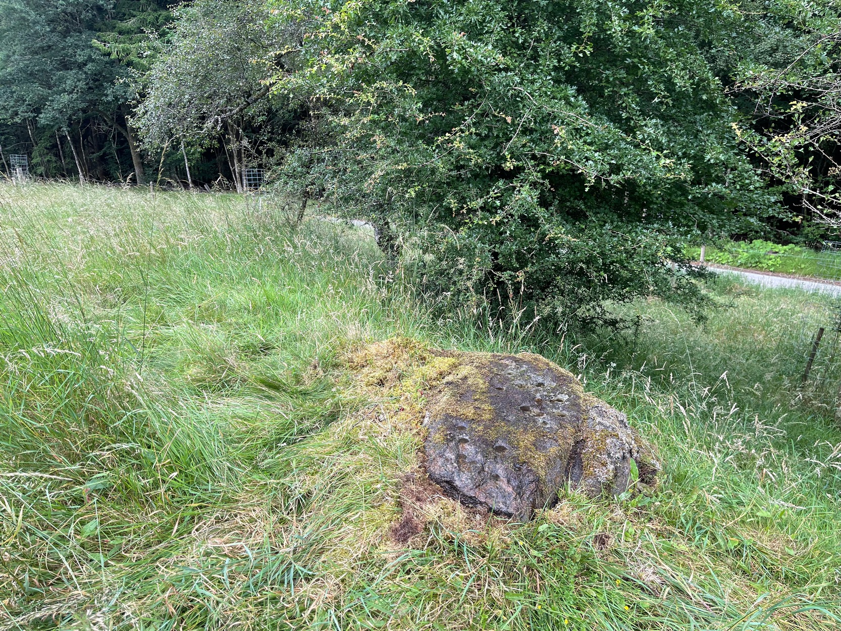
From Blair Atholl village along the B8079 road, take the minor road signposted to the Bridge of Tilt and go all the way to the top, taking the same directions as if you’re visiting the large prehistoric cairn of Monzie. As you walk towards Monzie farmhouse, you need to look at the large end-facing wall and on the ground at the bottom-left corner you’ll see this old cup-marked stone, next to an old bullaun.  It’s probably polite to knock and ask the farmer—who we found to be very helpful indeed. (huge thanks fella!)

Archaeology & History

This is an intriguing carving, inasmuch as its present habitat isn’t it original home.  When we visited the old stone recently, the farmer was very helpful and told us what he knew of it, which was, he said, “not much.”  In pointing out where it had originally come from, he pointed south, “past the fields – somewhere over there.  My dad knew about it,” he told, and thought that he may have been the one who found it.  Anyhow, it was his dad who brought it to the place where it now sits: right up against the edge of the house on its southeast corner.

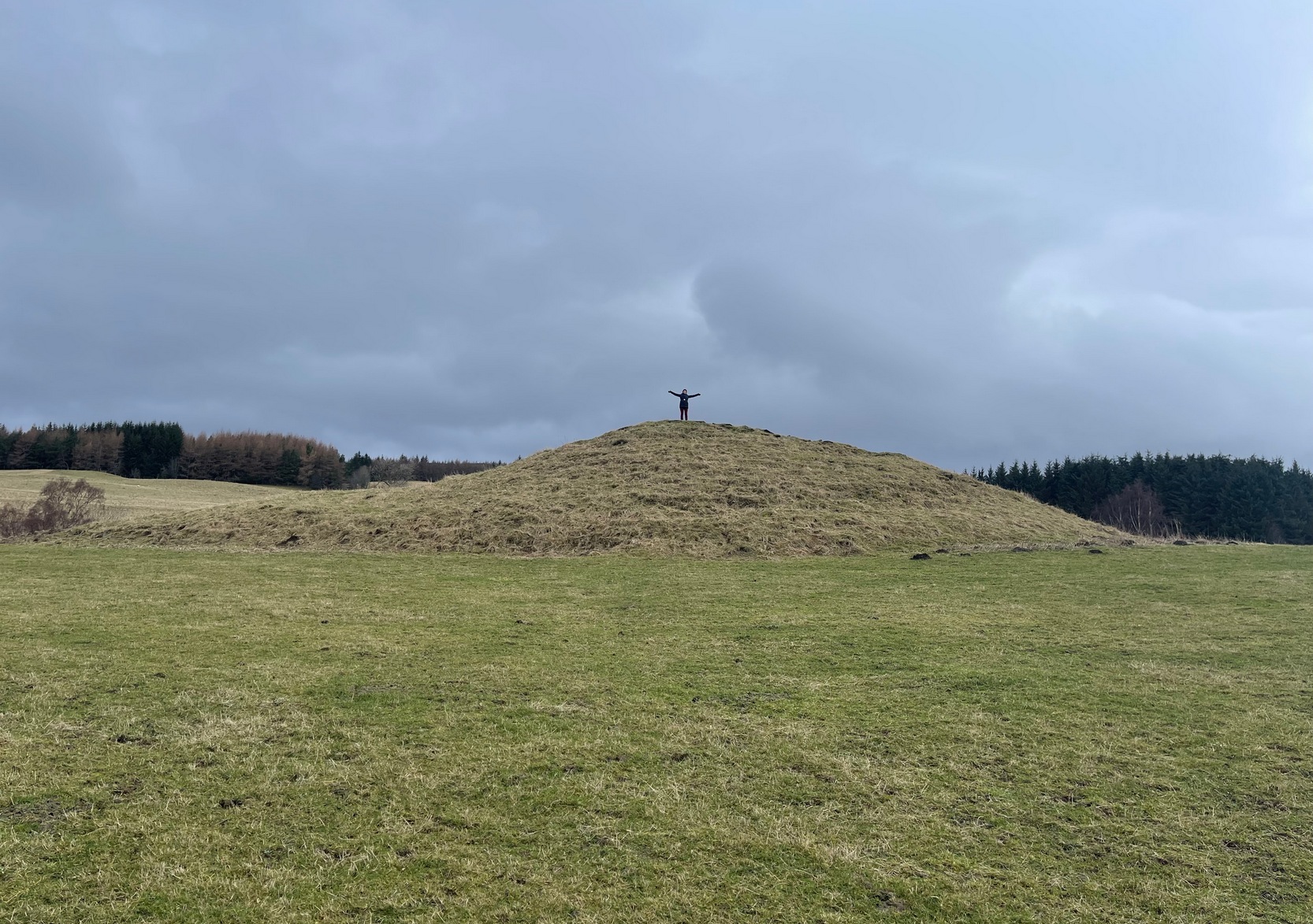
“It looks like it might have come from a tomb,” I said, but he didn’t know about that.  The giant cairn in the fields past his farmhouse certainly wasn’t where it had come from.  Quite the opposite direction… And so it transpired when I looked at the very menial archaeological notes that have been written about it.

When archaeologist Margaret Stewart noted the carving in the 1960s, she told how the stone had reportedly been found in 1953 by the ruined lime-kiln (NN 9052 6672), just above the western shore of Loch Moraig. But what she didn’t know was that the lime-kiln was built at the edge of the prehistoric tomb that was known to local people as Carndeshal, or Cairn Deshal.  The word deshal means sunwise, or the direction taken by the sun, clockwise, as in the word deosil.  It is usually associated with a ceremonial procession.  The cup-marked stone probably came from this cairn when it had been demolished and was thankfully saved by the farmer.

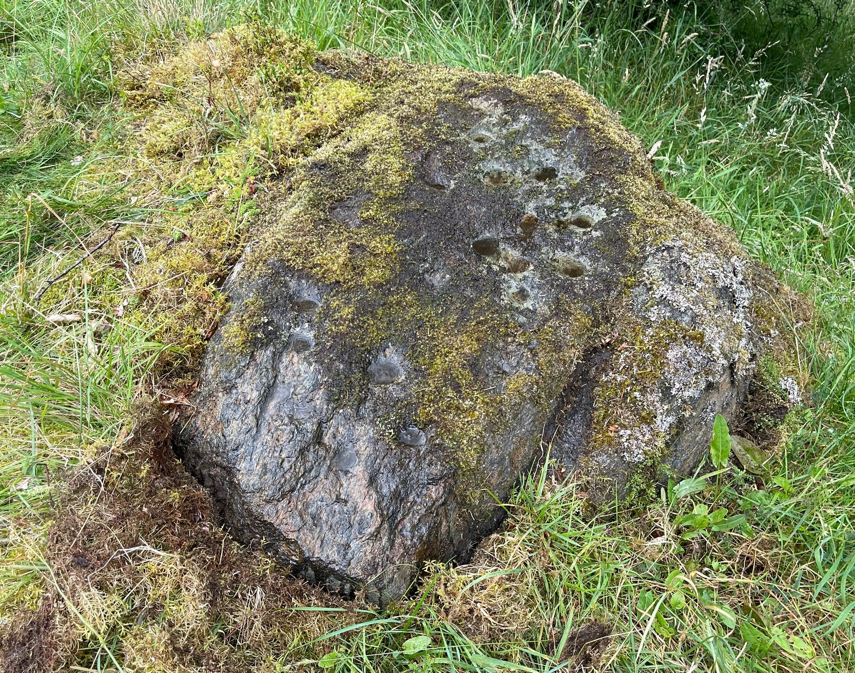
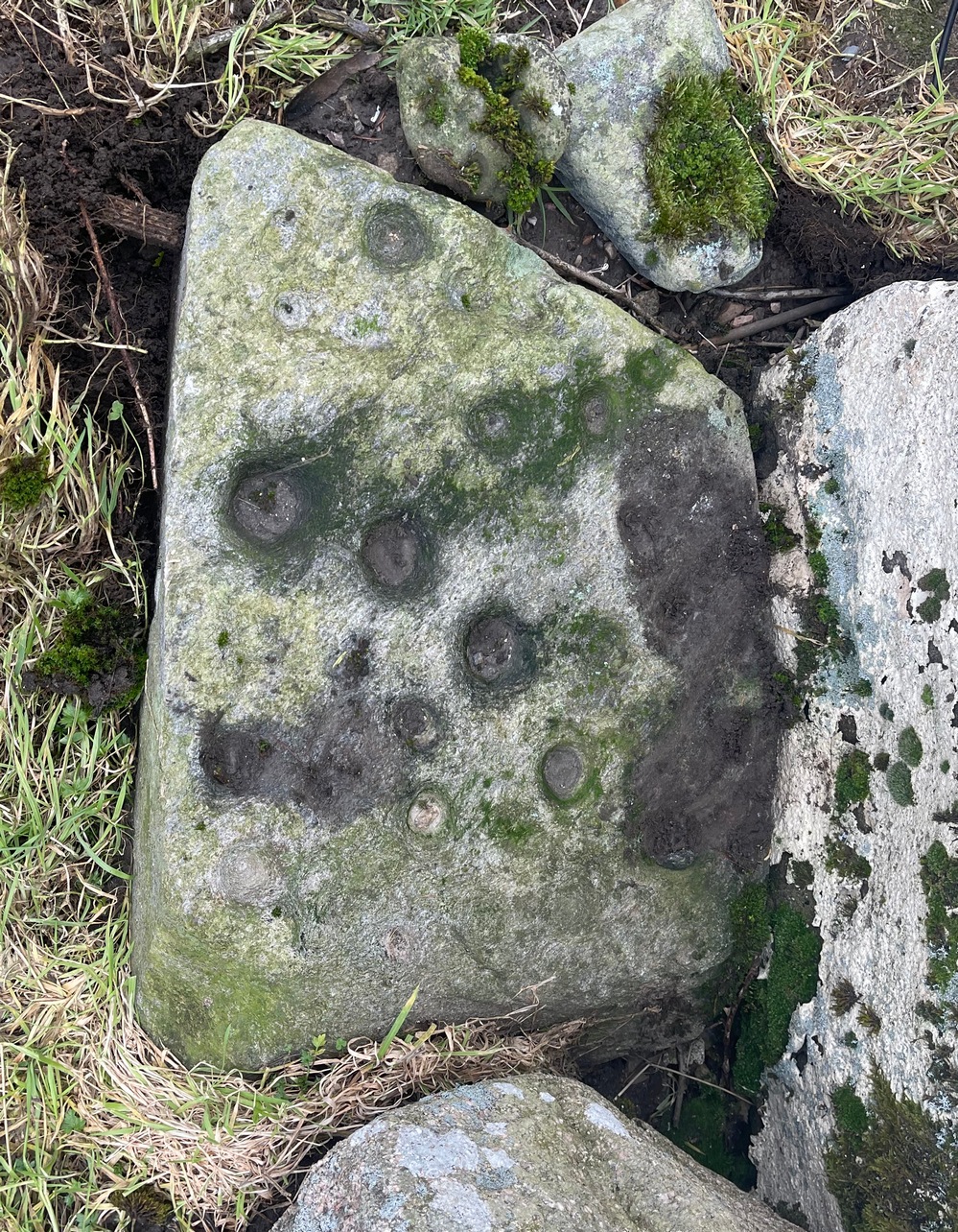
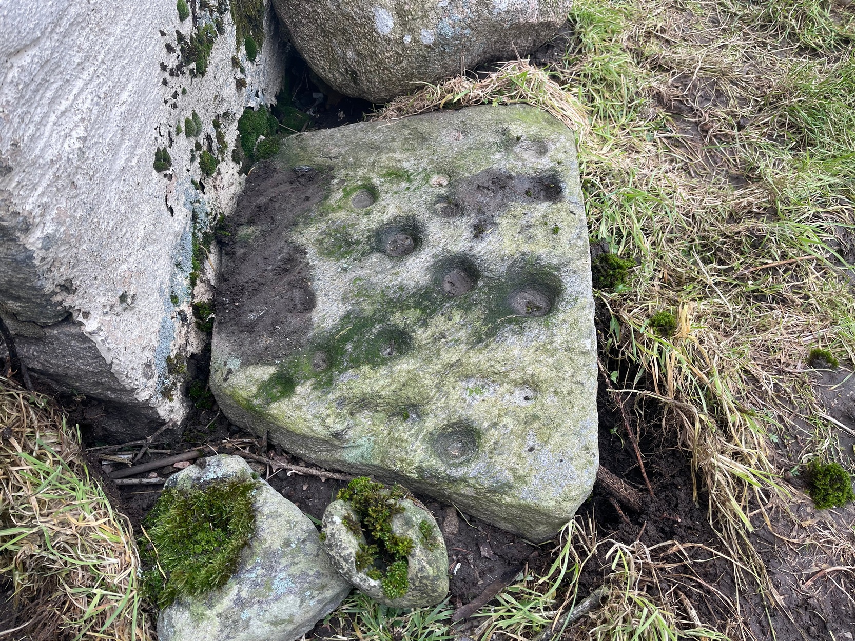
Altogether there are 24 or 25 mainly well-defined cup-marks on this thin slab, covering most of the surface.  In a couple of places on the stone, two of the cups are conjoined.  There are apparently no cup-marks on the other side of the stone.

Acknowledgements:  To my awesome Naomi – for getting us up here.

© Paul BennettThe Northern Antiquarian

Loch Moraig, Bridge of Tilt, Blair Atholl, Perthshire

Hut Circles:  OS Grid Reference – NN 9047 6722

Getting Here

Hut circle, outlined

Along the B8079 road in Blair Atholl village, take the minor road signposted to the Bridge of Tilt.  After half-a-mile, where the road splits, keep to the right and head further uphill and, where the almost-track-like road splits again another quarter mile up, bear to the right again and just keep going uphill for nearly two miles until your reach the large car-park on the left.  Park here.  Note the long straight line of walling on the top-side of the car-park that runs to the NW.  Walk along the other side of the wall and, after 100 yards, you go down the marshy dip and, once it rises up onto the small rise, truly truly truly keep your eyes peeled to see what lays beneath your feet.  They’re there – honestly!

Archaeology & History

As the years drift by, the remains of these two hut circles—separated barely ten yards from each other—have become increasingly difficult to see.  Upon our visit here, the hillside vegetation was at its lowest at the end of the Winter, yet it was still difficult to see them clearly, even when we stood right in them!  The land here is marshy and it’s spreading more and more into the soil, slowly but surely taking these old circles back to Earth, where all things return….

It’s there, under your nose!

The circles—and their half-dozen companions on the far-side of the wall—were shown to the archaeologist Margaret Stewart in the 1960s by the farmer at Monzie, who made notebooks of various places and traditions in this area.  Both of them are between 12 and 13 yards across, with the outlining walls that define them still thankfully visible above ground level—just!  The hut circle that’s closest to the modern wall is more oval-shaped than its circular companion, both of whom have their respective doors or entrances on the southwestern sides—but these were equally difficult to make out when we came here.

To be honest, if you’re wanting to see the hut circles, I’d head for those on the other side of the wall, two or three hundred yards to the west, which are much easier to find and are in better condition.

Acknowledgements:  To my awesome Naomi – for getting us up here.

© Paul BennettThe Northern Antiquarian

Monzie, Bridge of Tilt, Blair Atholl, Perthshire

Cairn:  OS Grid Reference – NN 90266 68032

Getting Here

Approaching Monzie cairn

Along the B8079 road in Blair Atholl village, take the minor road signposted to the Bridge of Tilt.  After half-a-mile, where the road splits, keep to the right and head further uphill and, where the almost-track-like road splits again another quarter mile up, bear to the right again and just keep going uphill for nearly two miles until your reach the large car-park on the left.  Park here and then take the dirt-track to the farm (truly friendly helpful folk) where, in the field to the rear of the buildings, a large unmissable mound rises up!

Archaeology & History

This is a bit of a beauty!  Hiding away on the southern edges of the Cairngorms we find this huge archetypal burial mound, 35 yards across and all but covered nowadays in deep layers of soil.  But it looks good.  When you walk onto its crown, about twelve feet up, you see and feel beneath you the scattered mass of small rocks and stones that comprise the monument as a whole, from top to bottom.  On its south-western side, the cairn is lower and elongated: this is due, on the whole, to where field clearance stones were pushed up against the monument many decades ago, making that side of it look bigger than it originally was.

Naomi on top for size!
Monzie cairn, looking W

Curiously perhaps, no archaeological attention of any worth has been give to the site apart from the usual estimates of its size and a guesstimate of it being neolithic or Bronze Age in nature (an easy thing to suggest).  On top, just beneath the grasses, is what may be the section of a small cist, but this may just be a fortuituous formation.  Excavation is required!  It’s one of a small number of old cairns and tombs in this locale, but this seems to be the biggest — unless, of course, the lost but legendary Carn Deshal, less than a mile to the south, stood larger…

Acknowledgements:  To my awesome Naomi – for getting us up here.

© Paul BennettThe Northern Antiquarian

Balrobbie, Killicrankie, Perthshire

Cup-Marked Stone:  OS Grid Reference – NN 90884 62571

Getting Here

The Balrobbie Stone

Roughly halfway between Blair Atholl and Pitlochry on the B8079 road is the village of Killiecrankie where, at the junction, you should take the road which leads you over the River Garry.  Crossing the river, follow the minor road swerving to the right and after nearly 200 yards bear left up the very minor road.  200 yards up there’s a hairpin bend; keep going up for about another 150 yards then walk into the overgrown grassland on your right where, just above an old hawthorn, a single notable rock protrudes.  Y’ can’t really miss it!

Archaeology & History

Some of the cups visible in poor light

On my visit here recently, the day was grey and overcast which, in tandem with there being a reasonably decent cover of mosses living on the stone, prevented me from seeing the complete design of this petroglyph.  I was thankful that it’s not an overly impressive one, so couldn’t be too disappointed.  It was was rediscovered in recent years by George Currie (2005) on one of his many forays, which, in his typically evocative language, he described as: “Rock, 1.5 x 0.9 x 0.7m, a few metres W of the Tenandry road; 24 cups, largest 50 x 18mm.”  Most of the cup-marks are a good depth and easy to see when you’re stood next to it.  Sadly my photos didn’t manage to capture them too well.

A notable hut circle can be seen a short distance away up the slope, barely visible in the summertime.  The carving may have been executed by the people living there.  This is the only recorded cup-marked stone anywhere near here which, as rock art junkies will tell you, is unusual.  Where there’s one, others tend to be living close by.  Happy hunting!

References:

  1. Currie, George, “Perth and Kinross: Balrobbie,” in Discovery & Excavation Scotland, volume 6 (New Series) 2005.

Acknowledgements:  Huge thanks for use of the Ordnance Survey map in this site profile, reproduced with the kind permission of the National Library of Scotland

© Paul BennettThe Northern Antiquarian

Whooping Cough Stone, Struan, Perthshire

Legendary Rock: OS Grid Reference – NN 816 653

Getting Here

Old photo of the stone (after Duncan Fraser)

Up the A9 past Blair Atholl, a few miles later there’s the turning for Struan.  Scarcely a mile east of old Struan Church, head past the old farmhouse of Old Kindrochat and keep going eastwards along the edge of the trees for about 200 yards until you reach the sheepfold. There you’ll see a singular rock sitting alone by the fence. That’s it!

Archaeology & History

This little known healing stone was, at one time last century, of great repute in the Highlands. Today, very few people even know it exists. One of many rocks that were said to possess healing abilities, this one (obviously) was of great repute in the curing of whooping cough. But it wasn’t the rock alone that did the work here, for upon its edge was a small basin into which rainwater collected and this, when used correctly and in due accord with ancient ritual tradition, could enact the cure.  Mr Duncan Fraser said of this fascinating healing stone:

“The grey water-worn stone is about 4ft 6in long, 2ft 6in broad and 2ft high, with a deep gash on top, where the water lingers even in long dry spells. When full it holds about half-a-gallon. People were still coming here with their sick children as late as 1860 — and bringing a spoon made from the horn of a living cow. There was no cure without that.”

The ritual “spoon made from the horn of a living cow” was an important ingredient at another site with the reputation for curing whooping cough about 50 miles south of here, near Balquhidder. (see Whooping Cough Well, Killin)  What truly fascinates me is the origin of this stone and its medicinal virtues.  When  did the healing rites first start here – how long ago…?

References:

  1. Fraser, Duncan, Highland Perthshire, Standard Press: Montrose 1969.

© Paul Bennett, The Northern Antiquarian