If you’re coming up from Otley or Askwith, take the same directions as if you’re going to visit the impressive Naked Jogger Carving (stone 612), not far from the well-known Tree of Life Stone. From the Naked Jogger carving, walk up to the small outcrop of rocks that bends above you. There’s a small collapsed line of walling just behind the outcrop. Walk along this up the slope as if you’re heading for the Sunrise Stone carving, but only 30 yards along, low down and right into the edge of the wall itself, you’ll see this elongated piece of stone. That’s the spot!
Archaeology & History
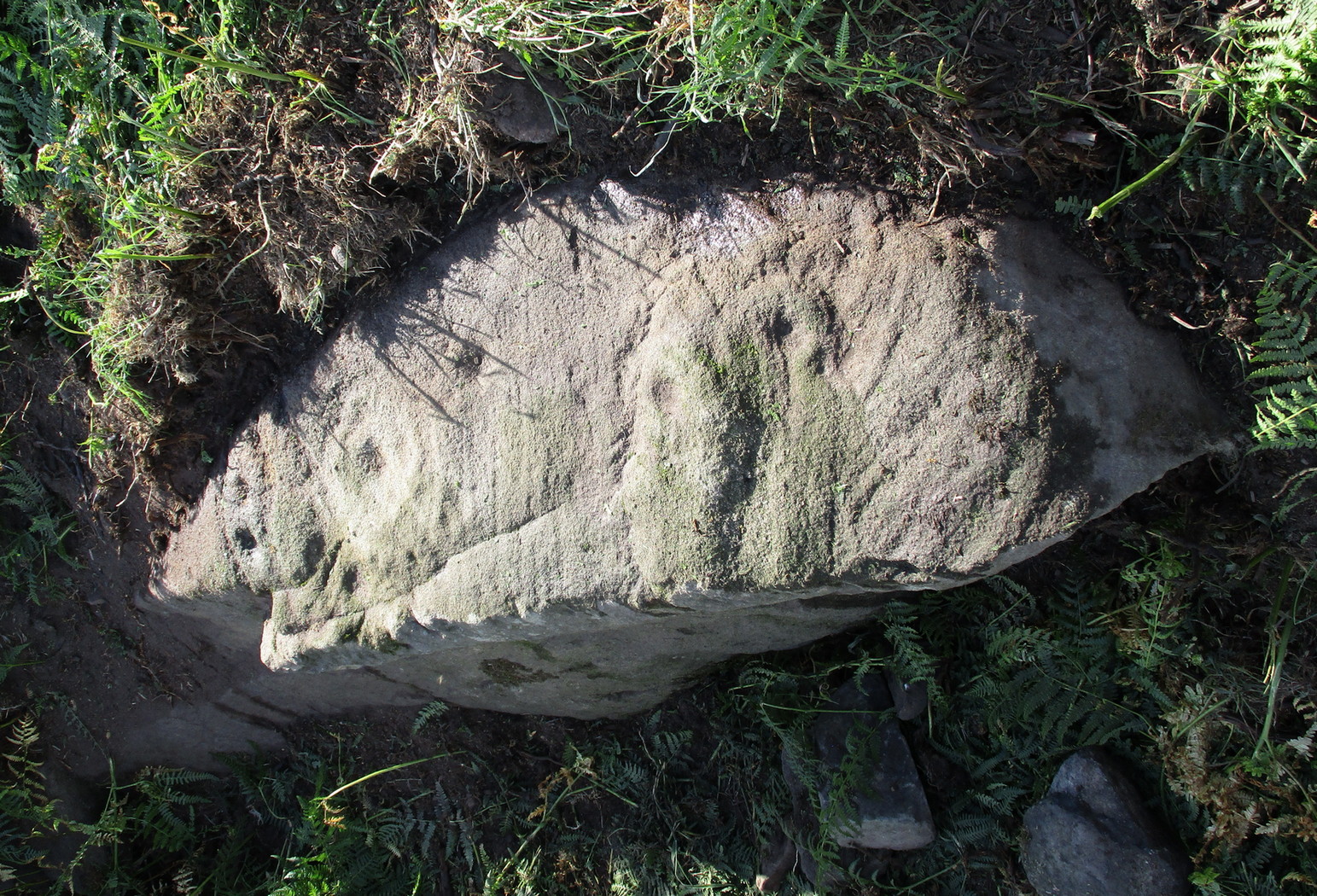
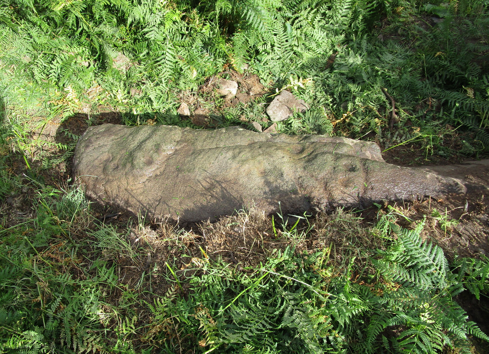
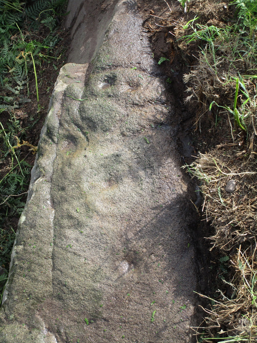
If you’ve caught the petroglyph-bug, you’ll like this one! It received its name from the curious fusion of natural cracks with the man-made pecked lines that shows, quite distinctly when the light is right and the stone is wet, the outline of two humanesque forms joined to each other. Figurative rock engravings of ancestors in the UK are extremely rare and when we came across this example, we noticed how the design could be interpreted as two Askwith Moor ancestor figures. Figurative rock art images elsewhere in the world such as the magnificent Wandjina paintings and the extensive galleries of figures engraved at Murujuga (Burrup Peninsula) in Western Australia, might provide an initial comparison, though more specific work needs to be done to better understand this unique petroglyph.
Sketch of the carving
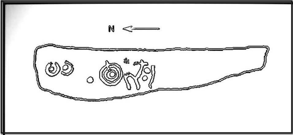
You can almost make out the figures in the above photo: the upper torsos of two beings on the right-hand side of the rock, almost fused together. And the carved shapes of these “ancestral beings” are morphically similar to some elements in the Sunrise Stone just 50 yards away – which themselves remind me of a Northumbrian carving near Doddington known as West Horton 1a. (Beckensall 1991) But we should’t get too carried away by the idea because—as we can see here in the sketch of the carving—when looked at from a different angle above, we could infer the right-hand carved elements to be representative of an animal: a deer, perhaps. Rorscharch’s once more tickle the exploring mind….
The rock has been quarried into at same time in the past (just like the nearby Sunrise Stone), leaving us to wonder what the complete carving might have looked like. No doubt some pieces of it will be in the collapsed walling either side of the stone. All we have left to see are the two unfinished cup-and-rings above the natural cracks that give rise to the “ancestral being” appearance. The faint double cup-and-ring has curious linear arcs to its side, with two well-defined cups enclosed by two of them. It’s a nice-looking carving when the light is good. The petroglyph was carved over a long period of time, as evidenced by the differing levels of erosion in different sections of the design. It’s a common attribute. The oldest section is the faint double cup-and-ring, whose mythic nature was added to / developed at a much later date, perhaps even centuries later.
In the always-expressive archaeocentric description of Boughey & Vickerman’s (2003) otherwise valuable tome, they told this carving to be,
“Long, narrow, thick rock of medium grit. Six cups, one with a double ring with a tab out and two with at least partial single rings, grooves.”
Evocative stuff!
It’s very likely that this carving had some mythic relationship with its close neighbours either side of it, probably over a very long time period and I’m inclined to think it somehow related to the rising of the sun, just like its solar companion further up the slope. Please note how I emphasize this ingredient in the site profile of its neighbour, the Mixing Stone 10-15 yards away—roughly halfway between this and the Sunrise Stone. A distinct place of ritual was happening in this close-knit cluster of carvings…
References:
Beckensall, Stan, Prehistoric Rock Motifs of Northumberland – volume 1, 1991.
Boughey, Keith & Vickerman, E.A., Prehistoric Rock Art of the West Riding, WYAS: Leeds 2003.
Reeder, Phil, “Snowden Carr Rock Carvings,” in Northern Earth Mysteries, no.40, 1990.
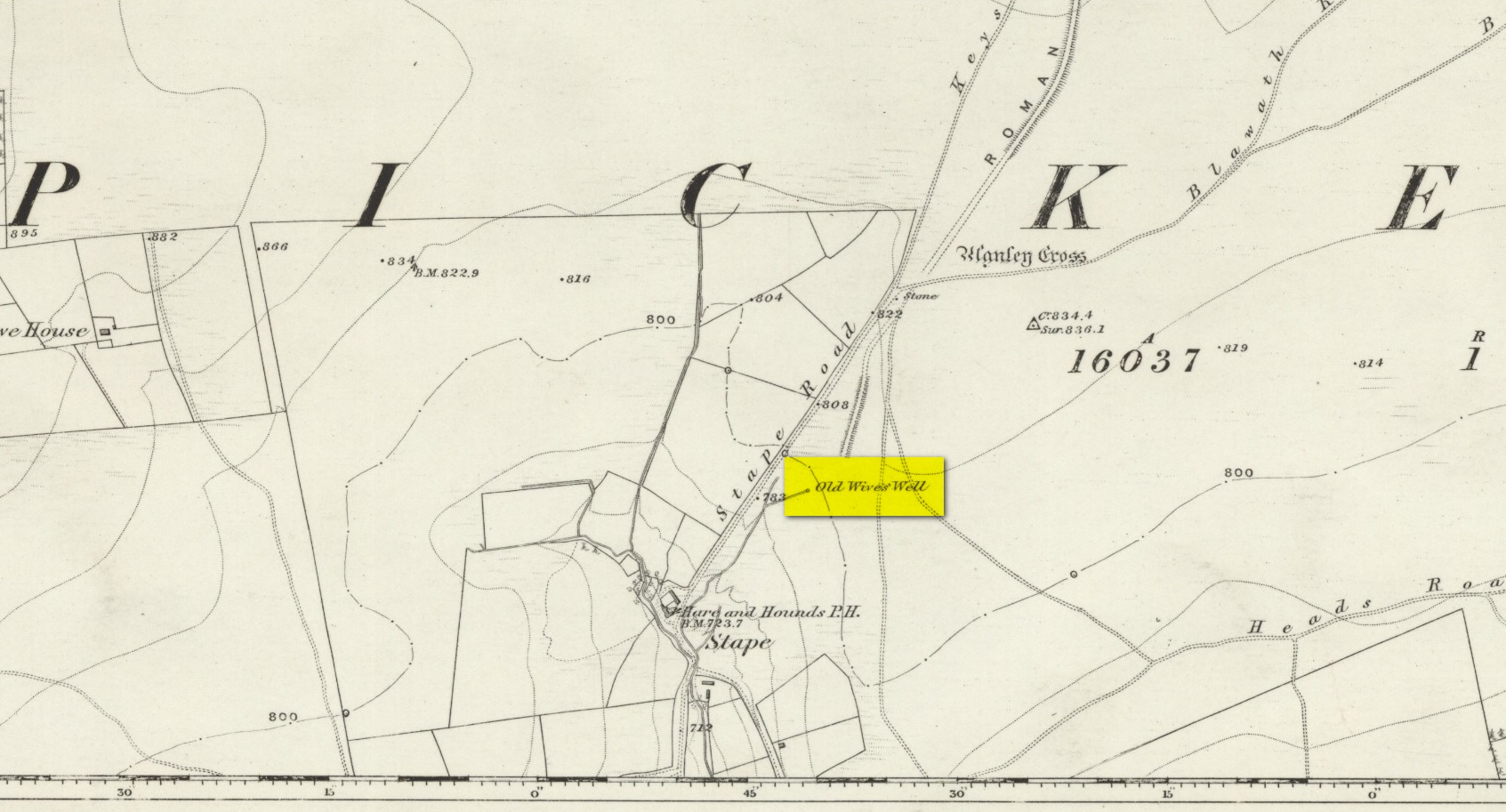
The history of the site is scanty to say the least. It first seems to have been recorded when the Ordnance Survey lads came here in the 1840s, although they left no record as to why the site was given such a dedication. It’s a decidedly pre-christian title as the name “old Wife” is usually indicative in northern counties as being related to the primal Earth deity of northern England and lowland Scotland (when we reach the Highlands and Ireland, She becomes known—amongst other names—as the cailleach). However, apart from its name we have no additional information. Neither the holy wells writer Edna Whelan (1989; 2001), nor hydrolatry researcher Graeme Chappell were been able to find anything about the place in their own researches. And so we must go on name alone…
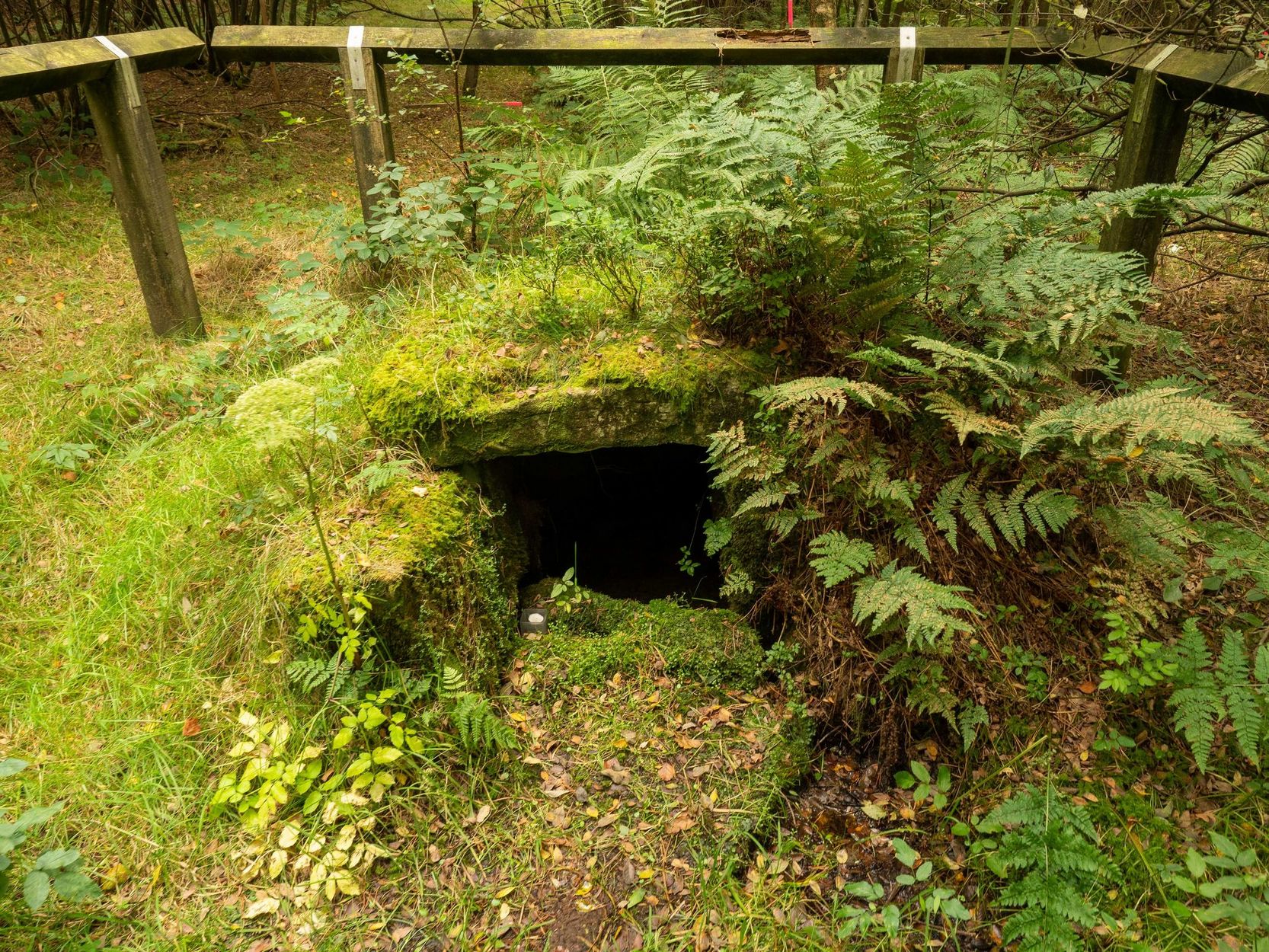
The waters bubble up into a small stone-lined chamber with the words Nattie Fontein carved into the lintel. This is something of a mystery in itself, for, as Edna Whelan (1989) told,
“it would be most unusual for the word fonten to be used for a spring in North Yorkshire: ‘keld’ is the local word. The rather roughly inscribed word may be a corruption of Fons Natalis, the name of a Celtic water nymph.”
Graeme Chappell (2000) meanwhile, noticed in a visit to the site in June 1999,
“that the N and A in “NATTIE” are carved in such a way that the word could be read as “MATTIE FONTEIN” perhaps meaning “Mother Fountain”. This might then be another reference to the Old Wife?”
He then goes on to note how,
“the latin word ‘natalis‘ meaning ‘birth’ and its link with the roman Festival ‘Dies Natalis Sol Invictus‘ (day of the birth of the unconquered sun) which took place on the 25th December. Natalis also gave rise to the welsh word ‘Nadolig‘ – meaning Christmas.”
This Yuletide element has an intriguing relationship with the name of the well; for to the west of Yorkshire’s borders into Cumbria there was annual gathering known as Old Wives’ Saturday that took place on the first Saturday after Christmas, or first Saturday of the New Year in a person’s house or inn, where a feast was had to bring in the New Year; but there is no known written lore of such a tradition here.
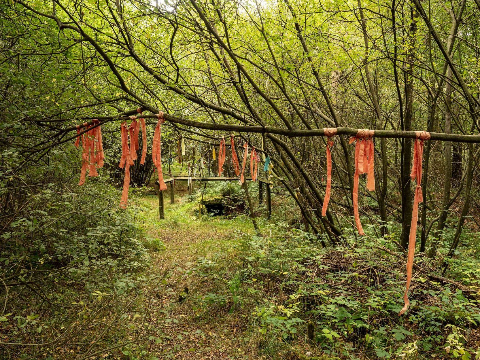
Nowadays the old tradition of hanging rags on the trees surrounding the well as offerings to the spirit of the place (known as memaws in parts of Yorkshire, and clooties in Scotland) has become a regular practice of those who hold such sites as sacred in their own way. Whelan mentioned seeing memaws here in the 1908s, but the Northern Antiquarian contributor Jon Barker told that, “The rags are a comparatively recent addition to the well, it is not a tradition there. When I used to go in the ’60s therewere no rags.”
On an even more curious note: very recently (from when this profile was written), the Northern Antiquarian contributor and photographer James Elkington visited Old Wives’ Well for the first time. It was a grey overcast day and when he arrived here, there was a woman ahead of him at the head of the well. I’ll let him tell the rest of it in his own words:
The Old Wives Well, Stape (James Elkington)Old Wives Well at Stape (James Elkington)
“In front of the well was a lady dressed in what looked like a white nighty, she had her back to me. There was a candle lit nearby, and her hands were in the water moving slowly about like she was washing something. She had long dark shoulder length hair. As I was about 25 feet away I was sure she wasn’t aware of me, and I thought it would make a good photograph. I quietly put my bag on the ground and got my camera out, and looked up and…she was gone! I couldn’t have taken my eye off her for more than 5 or 6 seconds. I looked all around and there was no sign of her. Even if she had legged it through the woods I would have seen her. I think it was then that I realized that I may have had ‘an encounter’. I quickly took three pics of the Well and got the hell out of there!”
He rang me once he had regained his senses in a somewhat emotional state and recounted over and over what had just happened. Whether this was a visual manifestation of the genius loci of the we can’t say. But such encounters are not unknown at numerous sacred water sites all over the world. We can only hazard a guess that this is what he was fortunate to encounter.
Just a few hundred yards north is the old Mauley or Malo Cross, which may or may not have had some mythic relationship with our Old Wives…
Perusal of a 25″ OS map of 1867 shows, in almost microscopic lettering, a feature marked ‘Bogle Bush’. I transferred the approximate location onto a modern map and set off to make a field visit, honestly not expecting to find anything almost a century and a half later.
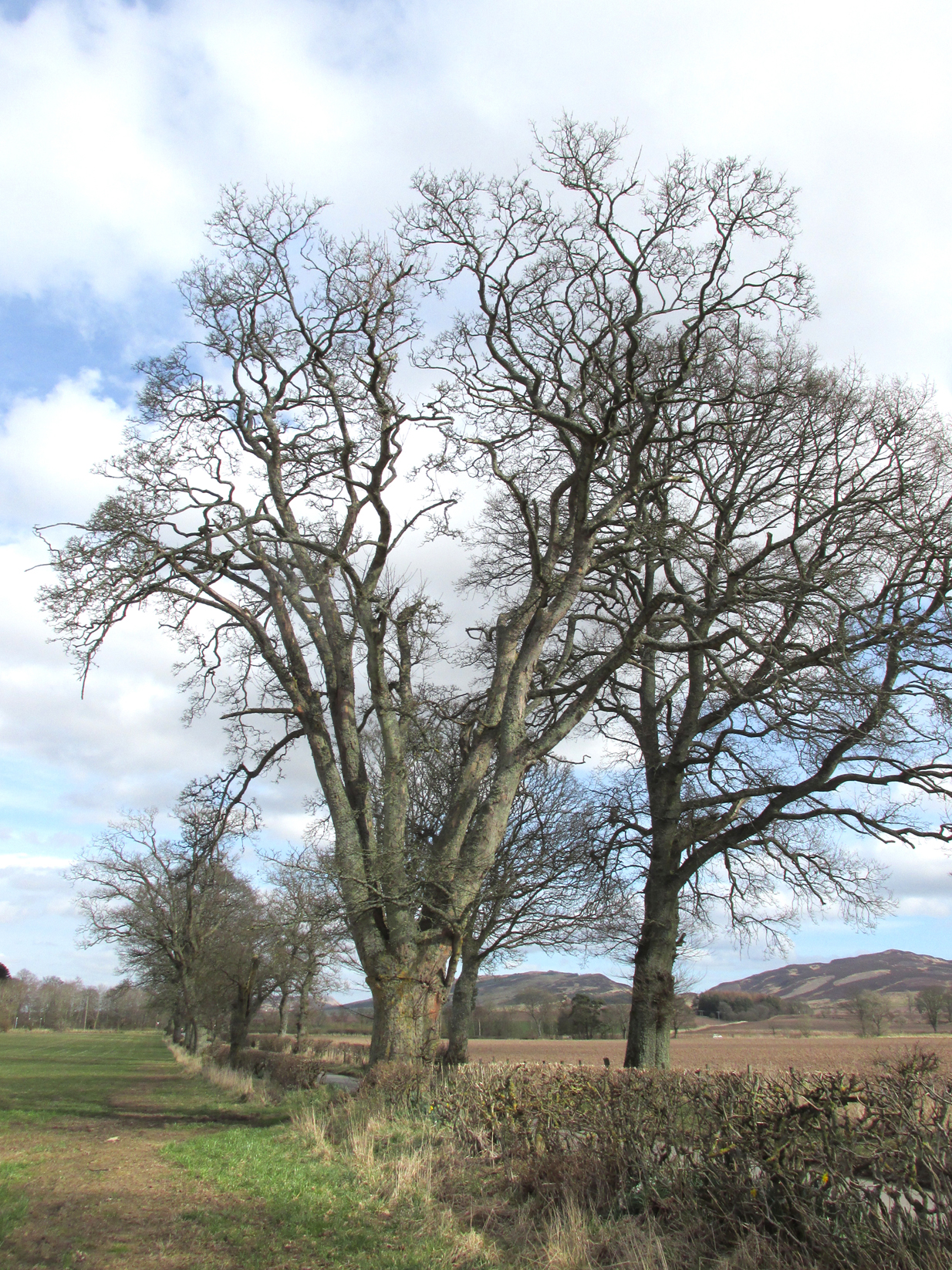
The Bogle Bush
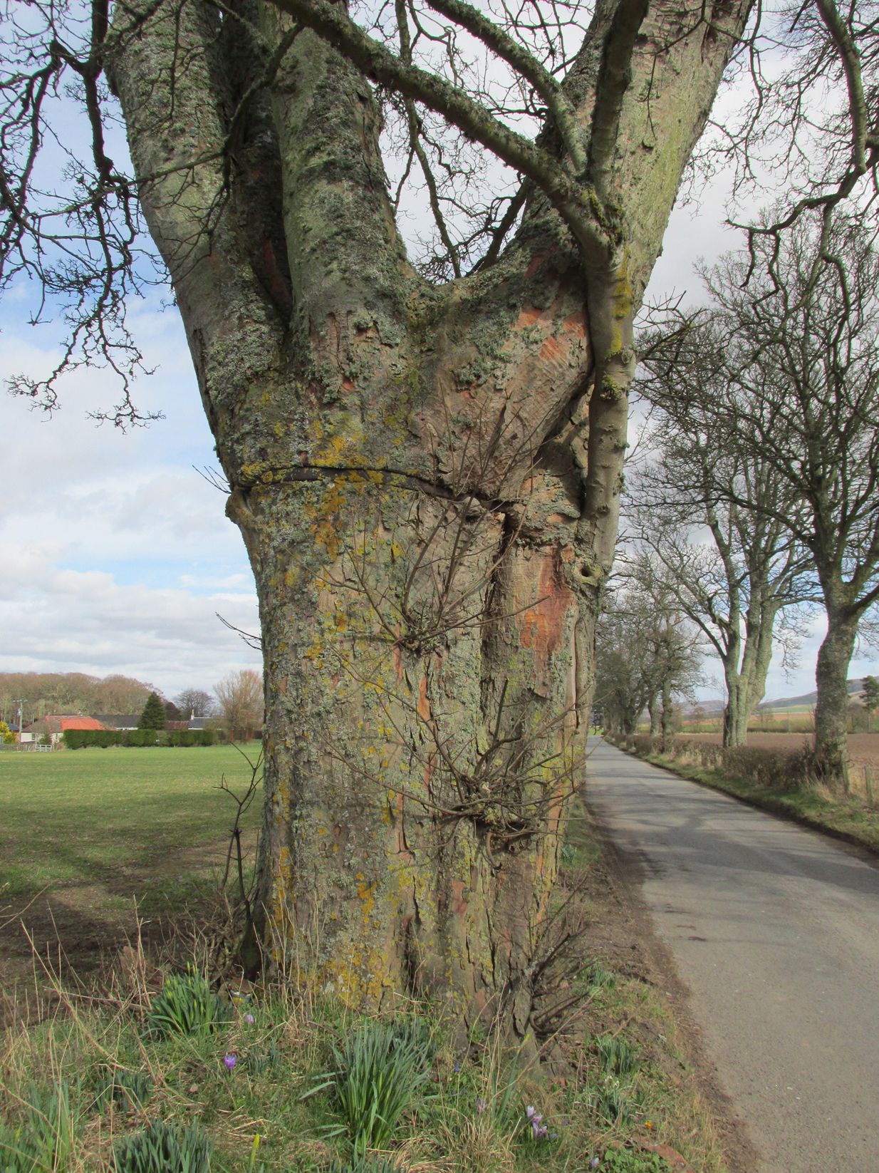
As I walked down the designated road I was drawn to an ancient multi branched or trunked tree, the trunks held together by a hefty iron band. The band had been placed there many years ago as it was being absorbed by the growth of the tree. Unlike the other trees in the road the foot of this tree had crocus and grape hyacinth in flower, as if deliberately planted.
The band was forged and fitted by Kinrossie Blacksmith and Kirk Elder David Gray at the end of the nineteenth century, following the collapse of one of the three trunks then standing.
The band holding the tree together
The online Ordnance Survey Name Books for Perthshire, compiled prior to the survey of the 1867 map, list Robert Millar of Flowerdale, Mr James Stewart of Kinrossie and Mr Fraser of St Euchans as the informants that ‘This name is applied to a Birch Tree situated on the north side of the road leading from Saucher to Kinrossie. Mr Millar says that there is a superstitious tradition existing in the locality that Bogles have been seen &c at this tree’.
Whether Mr Millar and his co-informants were trying to mischievously mislead the (probably) English Ordnance Survey officials, we will never know, but the tree is in fact a Sycamore! And the 1901 25″ OS map shows the tree as the ‘Bogle Busk’.
Folklore
There has been speculation that the Bogle Bush may have long forgotten links with Macbeth whose fortess at nearby Dunsinnan Hill overlooks it, adding the rider that Sycamores only live 200 years or so before falling and then regenerating on the same spot, implying that a mother tree could have been on the same spot in Macbeth’s time.
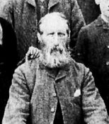
David Gray, Blacksmith and Kirk Elder of Kinrossie.
Local folklore states that ‘a great calamity will befall Kinrossie’ should the Bush collapse. The tree is a local icon that’s ‘aye been there’ according to a local resident and it seems to be a local geo-caching site, judging by the small container of ‘stuff’ hidden in a plastic container underneath a couple of pieces of bark at the base of the trunk on my visits.
Please note that if you decide to visit, this is not a wishing tree, so do not hammer coins into the bark or suspend rags from the branches. Respect the Bush and the local people to whom this is an iconic tree.
My thanks to local resident Morag Hislop for leading me to further information on this site.
Sacred Well (lost): OS Grid Reference – SE 160 339
Archaeology & History
Which one is the Cruckleswell?
In an essay by great regional historian Harry Speight (1912) on the ancient tracks of Bradford and district, he mentions this “Cruckleswell” which was first described in 1602. Mentioned again in 1612 land deeds and several times thereafter, the site has long gone (been built over), but may have been a place where local people ascribed there being water spirits, or naiads.
Although the local historian W.E. Preston (1932) described the place as being in fields between Manningham Stoop (an old boundary stone, now lost) and Hallfield Cross (perhaps an old stone cross site, also lost), a more detailed article appeared a few years later by Wilfrid Robertshaw (1935), telling of its approximate location. He wrote:
“The interesting field-name of Cruckleswell occurs in 1664. Cruckleswell was situated between Manningham Stoope and Hallfield Cross. The latter name is here applied to some closes of land near the Bradford-Manningham boundary and not to a monument; but from this qualifying statement must not be inferred the opinion that a stone or wooden cross of the name never existed. From Manningham Stoope, whose location I have not traced, a lane led to Fair Gapp, which was just within the town of Bradford; but in 1686 there was a close called the Stoope, which adjoined Manningham Lower Lane on the left-hand side from Bradford to Manningham. The occupiers of Cruckleswells were ordered by the jurors of the Bradford Manor Court to take in the water which ran by their premises. The occurrence of a water-course thereabouts, together with the name, Cruckleswell, suggests that here, as in the Panewell Feilde, was a holy well of a kind. Perhaps the derivation of the name may be found in the Yorkshire dialect word ‘crukle,’ meaning to make crooked, or to bend or twist. In a sense, therefore, Cruckleswell was another pin well, into which bent of ‘cruckled’ pins were cast. Cruckleswells, or Crookewells, as the three closes of land were called in a deed of 1658, were then granted by Tempest Brighouse, of Bilbie in the county of Nottingham, to James Mitchell of Bradford, yeoman. But…I have found a deed of sale by Christopher Pighells of Bradford, yeoman, to John Nicholls of Horton, clerk, of the close of land called Cruckleswell… Nicholls purchased Cruckleswell in 1612, the year before Saxton produced his plan, on which the small field is shown adjoining others belonging to Pighells. Thus the plan fixes the location of Cruckleswell; it adjoined the east side of the highway leading from Bradford to Frizinghall and was just within the Manningham township.”
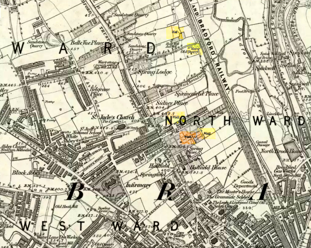
This would put it close to the Holy Well Ash well and its long-lost standing stone. The 1852 OS-map of this area shows an unnamed well between the Holy Well Ash and the boundary line, as highlighted above; but another unnamed well is to the north of the holy well. If we cross over the boundary line south and out of Manningham, three other wells existed less than 200 yards away. Anyone of these may have been the Cruckleswell.
Mr Robertson’s idea on the word ‘cruckle’ is echoed in A.H. Smith’s (1961) place-name analysis of the site, where he relates how the word is “possibly connected with the obsolete crookle, ‘to crook, bed.'” This is shown to be the case in Thomas Wright’s (1898) gigantic tome. And as “cruckling” pins was a common animistic practice in earlier centuries, this derivation of it—as being a well where offerings were given to the spirit of the waters—is not unlikely.
References:
Preston, W.E., ‘Some Local Holy Wells,’ in Bradford Antiquary, June 1932.
Robertshaw, Wilfrid (ed.), West Yorkshire Deeds (2 volumes), Bradford Historical & Antiquarian Society 1936.
Shepherd, Val, Historic Wells of Bradford, Heart of Albion: Wymeswold 1995.
Smith, A.H., The Place-Names of the West Riding of Yorkshire– volume 3, Cambridge University Press 1961.
Speight, Harry, ‘Ancient Streets and Lanes of Bradford as Portrayed in the Manor Court Rolls,’ in Bradford Antiquary, New Series 3, 1912.
Wright, Thomas, English Dialect Dictionary – volume 1, Henry Frowde: Oxford 1898.
From Fortingall, get to the standing stone of Adamnan’s Cross a few miles down the stunning Glen Lyon. Barely 100 yards before you reach the stone, notice the overgrown gorse-covered rocky rise across the road, just past Craigianie Farm. As you climb to the top of this small rocky rise, you’ll see a cairn of stones on its top. Just below it, into the solid rock, you’ll see a footprint-shaped hollow etched into the stone. If it seems hidden, just keep looking – you’ll find it…
Archaeology & History
St. Palladius Stone, Glen Lyon
When Ratcliffe Barnatt (1944) visited Glen Lyon in the 1940s, this legendary rock was one of his stopping points. “When we have passed by Ruskich and Slatich,” he wrote, “we come to that sacred spot, Craig Dianaidh, the Rock of Safety, where, until about 1480, solemn and judicial meetings were held.” The old rock was known through recent ages, “as a preaching hill, a motehill and a justiciary court,” said Hilary Wheater (1981), and upon its top is the curious ‘footprint’ which Nature’s blood would fill on all but the hottest of summers. It is this geological feature that gave the stone is name, long ago.
Of known historical events here, Wheater further told:
“It was on this rock…that the Baron Courts of Glenlyon were held. Law and order was kept by regular courts held by the Chief or Landowner. The Baron-Bailiary of each area was appointed by Royal Charter. Fifteen men were chosen as a jury and the laird or his baile presided. To this court were brought all the problems and grievances of the people. Here the miller accused several men of refusing to take part in the compulsory ‘hamganging’ of a new millstone; here a man was fined for brewing ale without a license; here a neighbour was accused of putting the ‘evil eye’ on the cow of the croft next door so it produced no milk; and here a man was prosecuted for ‘taking of ane sore horse of his to Rannoch in the summer of 1629 and putting on him ane great burder of timber, and letting him go through the wood where he stuck between two trees all night and the timber on his back.’ However, he was acquitted when he was able to prove that the horse was fit enough after this for another man to be able to take it to Edinburgh soon after.”
St Palladius Footprint
As well as being a moot site, it is more than probable that this footprint, like the one near the top of Dunadd in Argyll—and others scattering the Highlands and beyond—was an initiation stone, perhaps for local tribal elders or ancient kings. Janet Bord (2004) writes about them as places of ritual inauguration in her survey of such places.
Folklore
The legendary site, looking south
This legendary rock would probably have had earlier mythic association than the one ascribing it to St. Palladius—but as yet I have found no written lore telling the nature of such a spirit, so would only perhaps discern the original genius loci by lengthy encounters with the rock in question, through mist and storm and wintry months, alone. It is known in local folklore that Palladius was in fact an urisk: a solitary spirit of steep streams that few humans encounter due to their lonely habits amidst hidden abodes in dark and ancient gorges. Such urisks dwelt in numbers amongst many of the steep falls in this landscape — and still do, if the words of old locals are to be believed. Here,
“St Palladius was a goblin saint, an urisk that dwelt in a mountain burn and was sanctified by the people.”
…and some rocks by the stream up the mountain immediately above this “footprint” was one of the places the urisk was known to dwell.
…to be continued…
References:
Barnatt, T. Ratcliffe, The Road to Rannoch and the Summer Isles, John Grant: Edinburgh 1944.
Bord, Janet, Footprints in Stone, Heart of Albion Press 2004.
Fraser, Duncan, Highland Perthshire, Standard Press: Montrose 1969.
Wheater, Hilary, Aberfeldy to Glenlyon, Appin Publications: Aberfeldy 1981.
Up the A9 past Blair Atholl, a few miles later there’s the turning for Struan. Scarcely a mile east of old Struan Church, head past the old farmhouse of Old Kindrochat and keep going eastwards along the edge of the trees for about 200 yards until you reach the sheepfold. There you’ll see a singular rock sitting alone by the fence. That’s it!
Archaeology & History
This little known healing stone was, at one time last century, of great repute in the Highlands. Today, very few people even know it exists. One of many rocks that were said to possess healing abilities, this one (obviously) was of great repute in the curing of whooping cough. But it wasn’t the rock alone that did the work here, for upon its edge was a small basin into which rainwater collected and this, when used correctly and in due accord with ancient ritual tradition, could enact the cure. Mr Duncan Fraser said of this fascinating healing stone:
“The grey water-worn stone is about 4ft 6in long, 2ft 6in broad and 2ft high, with a deep gash on top, where the water lingers even in long dry spells. When full it holds about half-a-gallon. People were still coming here with their sick children as late as 1860 — and bringing a spoon made from the horn of a living cow. There was no cure without that.”
The ritual “spoon made from the horn of a living cow” was an important ingredient at another site with the reputation for curing whooping cough about 50 miles south of here, near Balquhidder. (see Whooping Cough Well, Killin) What truly fascinates me is the origin of this stone and its medicinal virtues. When did the healing rites first start here – how long ago…?
References:
Fraser, Duncan, Highland Perthshire, Standard Press: Montrose 1969.
Follow the same directions to reach the superb Badger Stone carving, and from here take the footpath that runs downhill. You’ll cross another footpath about 100 yards down the moor, but just keep walking down the path and you’ll notice the small copse of woods ahead of you. As the footpath begins to swerve roughly away, northeast, heading away from the said woodland, keep your eyes peeled on your left for a reasonably large but flattish rock close to the ground (in summer it’s surrounded by bracken) about 75 yards away. That’s your target!
Archaeology & History
Of the hundreds of cup-and-ring stones on Ilkley Moor and district, this is one of my personal favourites! I first visited the stone in 1977 as a young teenager and was mightily impressed by the unusual nature of the design here — and that impression still remains. Aswell as possessing the usual cups and rings, the Barmishaw Stone is one of just a few rocks also possessing a sort of ‘ladder’ design or linear pattern within the overall carving: an insignia echoed on the nearby Willie Hall Wood carving, the Piper Stone, and also on the Panorama Stones. As with the ‘ladders’ on the Panorama carving, those found here at Barmishaw are very eroded and are increasingly difficult to see during the daytime (the best time to notice them is usually around sunrise or sunset, and particularly when the rock itself is wet).
The carving has been described many times, albeit briefly, by a number of writers. In John Hedges (1986) fine survey he said the following:
“Medium sized flat-topped rock…fairly smooth grit, sloping slightly east to west, covered with carvings, some of which are very worn. Slanting sunshine needed to detect them. About twenty-four cups, at least nine with rings or incomplete rings, two with multiple grooves half round and continuing straight down, one of them incorporating ‘ladder.’ Five other ‘ladders’ – in a good light. Cups mostly deep and clear.” A few years later, Boughey & Vickerman (2003) echoed much of Mr Hedges description, though noted that of the 24 cups with their rings, one possessed a triple ring.
Alan Davies’ illustration
Like so many cup-and-ring stones, they have given rise to hosts of fascinating theories and ideas — one of which is based on mathematics and metrology. In the 1980s, Alan Davies (1983, 1988) surveyed the Barmishaw Stone — and other carvings on Ilkley Moor — to explore the possibility that the cups and rings were laid out according to a basic unit of measure, the Megalithic Inch (MI), as proposed by Alexander Thom some years earlier. Although Davies’ work showed that such a primary unit of measure wasn’t to be found universally, his research at the Barmishaw Stone indicated “significant evidence for quanta of…3 MI,” although this occurred “when the analysis is restricted to only ringed cups.” Despite this, Davies thought that the existence of the Megalithic Inch was evident in this and other carvings on the moors, stating that:
“The repeated emergence of the significance of ringed cups, and the fact that all putative quanta seem to bear a simple numeric relation to each other do not seem to be coincidental.”
Although it has to be said that the selectivity of data in Davies’ research is more indicative that the Megalithic Inches in the the carvings was due, neither to chance nor mathematics, but more that the implements used to carve the rocks and the size of the hands of the people doing the carvings was pretty uniform and so, as a result, would give an obvious window of numeric similarities that can easily be mistaken as a deliberate metrology. These simplistic factors need assessing. In modern trials that we’ve done carving cup-markings, we’ve found them to be of similar size to those carved in prehistoric times—as you’d expect.
Barmishaw Stone (after Hedges, 1986)Barmishaw stone (Cowling 1946)
The ladder motif central to this carving may have related to early religious and ritual events here. Across the world, indigenous cultures commonly relate the ‘ladder’ to be a symbol of ascension, both by shamans, mystics and during rites of passage. The symbol represents the journey of the soul to and from supernatural realms. To discount this possibility at the Barmishaw Stone would be shortsighted.
The carving was very probably painted when our neolithic ancestors gathered here, much as Australian aborigines still do to their carvings using lichens and other plant dyes, with the respective ladders and lines changing colour where movements between worlds or shifts of attendant spirit occurred. By virtue of the its very name, I consider this rock to have been considerably important; the “ghost” aspect to barmishaw being a typically misconstrued aspect of ‘spirit’.
Folklore
This excellent cup-and-ring marked stone probably derives its name from the old dialect words “barm i’ t’ shaw”, meaning “ghost in the wood” stone. Whatever guise the attendant spirit of this rock may have had has long since been forgotten; though spectral accounts from the beginning of the nineteenth century until modern times may give us clues. There have been several reports of green-coloured elemental creatures around the area between here and the White Wells sacred spring a short distance to the east. The most recent account, from 1987, took on the modern mythic form of a little green man from space, with attendant UFO to boot! The Barmishaw Hole nearby was a place where faerie-folk used to live. Excesses of geological faulting and water makes the magickal nature of this place particularly potent.
References:
Allen, J. Romilly, “The Prehistoric Rock Sculptures of Ilkley,” in Journal of the British Archaeological Association, volume 35, 1879.
Allen, J. Romilly, “Notice of Sculptured Rocks near Ilkley,” in Journal of the British Archaeological Association, volume 38, 1882.
Bennett, Paul, “Cup-and-Ring Art”, in Towards 2012, volume 4, pp.83-92, 1998.
Bennett, Paul, The Old Stones of Elmet, Capall Bann: Milverton 2001.
Boughey, Keith & Vickerman, E.A., Prehistoric Rock Art of the West Riding, WYAS: Wakefield 2003.
Cowling, E.T., ‘A Classification of West Yorkshire Cup and Ring Stones,’ in Yorkshire Archaeological Journal 1940.
Cowling, E.T., Rombald’s Way: A Prehistory of Mid-Wharfedale, William Walker: Otley 1946.
Davis, Alan, ‘The Metrology of Cup & Ring Carvings near Ilkley in Yorkshire,’ Science Journal 25, 1983.
Davies, Alan, ‘The Metrology of Cup and Ring Carvings,’ in Ruggles, C., Records in Stone, Cambridge University Press 1988.
Eliade, Mircea, Patterns in Comparative Religion, Sheed & Ward: London 1958.
Hedges, John (ed.), The Carved Rocks on Rombalds Moor, WYMCC: Wakefield 1986.
Wright, Joseph, The English Dialect Dictionary – volume 1, Henry Frowde: Oxford 1905.
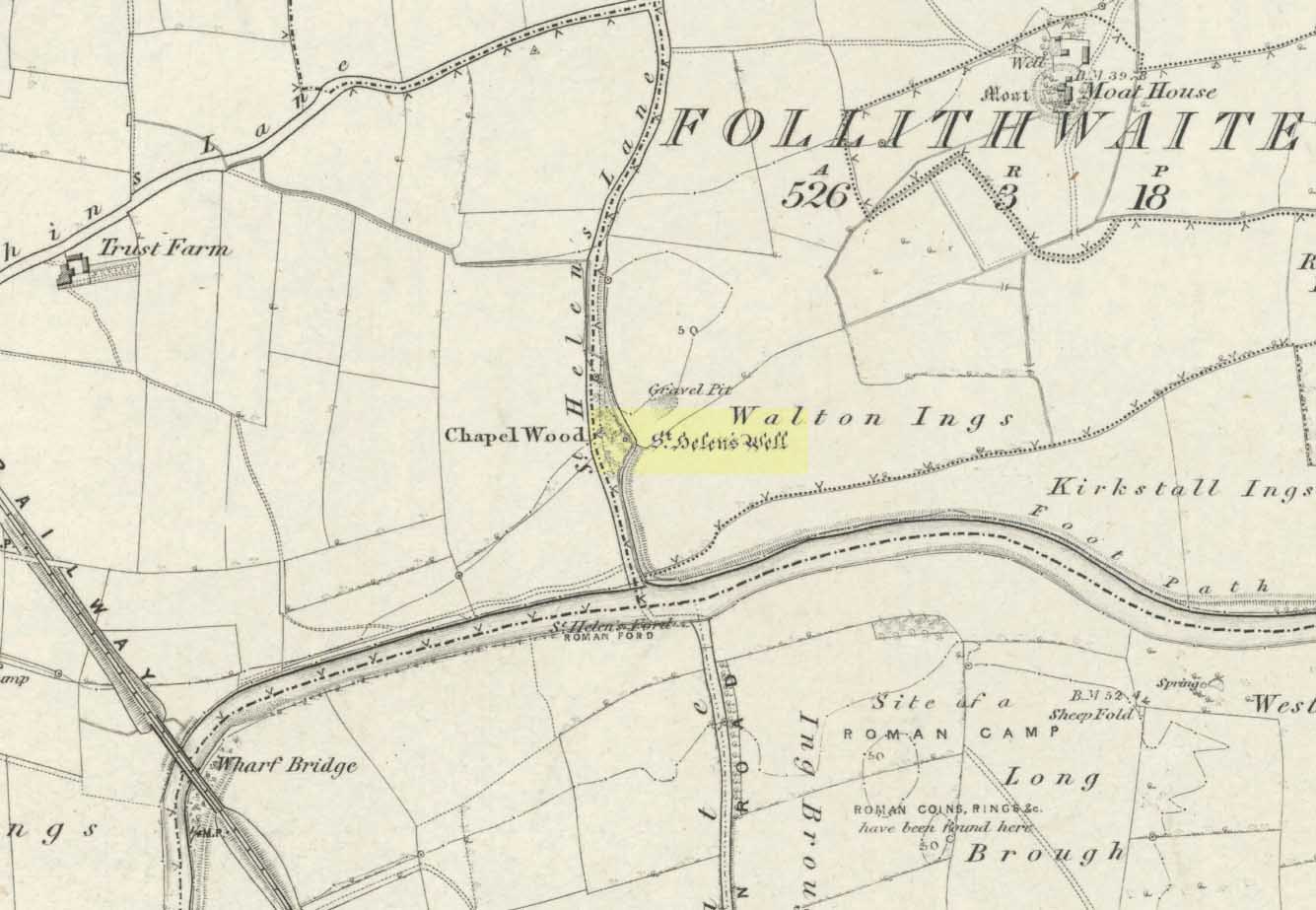
The well is all dried up today, but its remains are about 200 yards north of the river Wharfe. Sam Brewster (1980) told the easiest way to find it: “To get there from Thorp Arch you take the trackway that goes to the south of the church and follow this until you are walking alongside the river; eventually you will come to a barrier of barbed wire near some old disused water-works; get under or over this barrier and turn 90 degrees to your left, following the barbed wire until you come to a wood, the other side of the barbed wire; go into the wood and turn right; keep exploring near the edge of the wood until you find a tree under which is a hollow which used to be St. Helen’s Well.” Once here you can see where the water used to flow down a narrow channel and under a little bridge.
Archaeology & History
Carved cross remains found near St Helen’s Well
This ancient and well-known healing spring is shown on early OS-maps emerging a short distance north of the River Wharfe besides St. Helen’s Beck in Chapel Wood, adjacent to the Kirkstall Ing or field. In the western fields close by was once an ancient chapel and, closer to the holy well, once “stood St. Helen’s (or St. Helena’s) Cross, which is somewhat crudely represented in Dr. Whitaker’s History of Craven“, (Speight 1902), illustrated here.
This well possesses a prodigious occult history yet is curiously absent from most studies on the subject. The place is said to have been a respected holy site that was venerated long before the Romans arrived here. Found at a place called the Rudgate — but known locally as St. Helen’s Ford — it is also said to be haunted. Angela Smith (n.d.) considers the traditions surrounding the well to be pre-Roman, and the curative waters would certainly have been known of at the time of their occupation here,
“because it lies at the side of Roman road No.280, just north of where it crosses the River Wharfe at St. Helen’s Ford, leading to the Roman fort at Newton Kyme.”
St Helens Well in 1900
Several species of psychoactive plants grow adjacent to the well, which are thought by Phillips, (1976) Devereux (1992) and I as serving ritual shamanic purposes. The likelihood is more so than not. The oracular nature of the site which R.C. Hope (1893) and others have described here is particularly interesting: in traditions the world over, oracles were often consulted after the ingestion or use of sacred plants, such as are found here.
Due to the sacred nature of this spring and its importance in local folklore and history, it should be recovered from its present state. The fact that this place was highly important as a ritual and sacred site to christians, pagans, Romans and peasants alike, and now hides all-but-lost and forgotten is a disgrace.
Folklore
A fascinating tale hangs over this still-revered holy well which legend tells had a chapel standing adjacent, dedicated to Helen in the 7th century – although no trace of it is visible today. Local historian Edmund Bogg (1904) recounted how a local sexton told of “padfoots and barguests and ‘that grim foul beast with clanking chain’ which on dark nights kept its vigil” near St.Helen’s Well. Padfoots and barguests are Yorkshire names for spectral black dogs, said to be bringers of death and misfortune (they are one of several remaining folk-ingredients from the Underworld myths in British shamanism).
St Helen’s Well, c.1935St Helens Well in 1934
Folklorist Guy Ragland Phillips (1976), referring to an article in The Dalesman in 1971, told how a Mrs Dorothy Tate as a young girl used to visit the site and would tie pieces of rag on the bushes aside the place as grateful offerings to the spirit of the well. She said however, that she had gone about doing this in the wrong way, as according to tradition such offerings are to be done secretly. The article showed a photograph of Mrs Tate (from 1908) tying one of the memaws to the wych-elm tree overhanging the old spring.
People visited the well – probably on August 18 – to divine the future with the oracle which Hope (1893) described as being here, always in the dead of night without being seen, leaving before sunrise. It has been visited by thousands of people over the centuries, with gifts of rag-hangings, pins and other memaws. Such offerings continue even to this day. When Harry Speight (1902) visited St. Helen’s Well at the turn of the century, he related how as many as forty or fifty hangings would be left at any one time on the branches of the trees. He wrote:
“The water is beautifully soft and clear, and in former times was much resorted to as a specific for sore or weak eyes. There are two other springs close by, which were also held to be sacred, but they do not bear any particular dedications. An old plantation a little north of the well is known as Chapel Wood, which commemorates St. Helen’s chapel and the ancient church at Bilton, three miles further north, and about a mile to the east of the Roman Rudgate, is also dedicated to St. Helen.”
A few years before Speight’s visit here, Dr Fred Lees and the botanist, Robert Baines, visited St. Helen’s Well, and wrote similarly of the lore and memaws they found there:
“There are veritably hundreds of these bedizenings affixed and removed surreptitiously (probably before sunrise), according to an unwritten law, for none are ever caught in the act. And yet during the summer months a careful observer may detect almost weekly evidence of a shy communicant with the ghostly genius of someone¾country maid or her dumb shy swain. What murmured litany (if any) had to be said is lost; most likely nothing more was necessary than the unspoken wish…Pieced together and codified, fact and heresay testify as follows: ‘The visitor to the grove, before rise of sun, has to face the tree [a wych-elm overhanging the well] to detach from his or her own person some garment, to dip it in the well, and having knotted or whilst hanging the fragment to any convenient twig…is to breathe a ‘wish’ telling no-one what that wish may be; these conditions strictly observed, what is desired shall come to pass.'” (in Phillips, 1976)
When the archaeologist C.N. Bromehead (1935) and geologist J.V. Stephens came to the site in the 1930s, despite the fall of the well, he was surprised to find local peasants still respecting the spirits of the site, reporting:
“There is now no well or visible spring, but from the position at the lower margin of a gravel terrace it is obvious that water would be obtained by digging a few feet; a small stream flows just east of the site… It is curious that the hanging of rags should survive when the actual well has vanished, but the writer has visited the spot many times in the last seven years and there are always plenty of obviously recent additions. The custom is to stand facing the well (i.e., due west), preferably after sunset, wish, and then attach something torn from one’s clothing either to the big tree — wych elm — or to any of the bushes. Probably the custom is largely maintained by vagrants who frequently camp in the wood, but it also has its attraction for courting couples from the neighbouring villages!”
Such offerings at the site of St. Helen’s Well are still left by locals and some of the plastic pagans, who tie pieces of artificial material to the remnants of the wych-elm and other trees, which actually pollutes the Earth and kills the spirit here. Whilst the intent may be good, please, if you’re gonna leave offerings here, make sure that the rags you leave are totally biodegradable. The magical effectiveness of your intent is almost worthless if the material left is toxic to the environment and will certainly have a wholly negative effect on the spirit of the placehere. Please consider this to ensure the sacred nature of the site.
…to be continued…
References:
Bogg, Edmund, Lower Wharfeland, the Old City of York and the Ainsty, James Miles: Leeds 1904.
Brewster, Sam, ‘St. Helen’s Well,’ in Wind & Water 1:4, 1980.
Bromehead, C.N., ‘Rag Wells,’ in Antiquity IX, March 1935.
John Dixon took a bunch of us on a pleasant amble here via the Fair Oak Circle site. From Fair Oak, go round the back of the farm and past the small cluster of hidden cottages, then bear right down the dirt-track and up the slope, then cross the field in front of you, going over the stile, following the footpath round the eastern edge of the slightly limestone New Laund Hill, and down again, thru the gate. From here, head diagonally across the field 150 yards towards the fencing at the woodland edge. Over the fence, into the trees, head halfway down the steep-ish slope and keep your eyes peeled for the rocky outcrop nearly halfway down. Alternatively, an easier way here is apparently from the Inn at Whitewell. Go across the river via the stepping stones (or wade!) and follow the footpath uphill towards a farm, where you’ll find a large steel gate on the left that leads into the woods. Here there are 2 paths: follow the higher of the two until it starts bearing to the right. Once here, look up the hill to the right you’ll see the rock outcrop. The caves are there!
Archaeology & History
Smaller Fairy Hole
There are at least 3 caves here, close to each other along the edge of the small footpath a few yards apart. The small rounded entrance of the northernmost one (photo, right) is reported by English Heritage to have had no human remains found therein, but further investigation is required here. The main cave however is where intriguing prehistoric finds were located. It appears that the entrance was deliberately built-up and blocked by stone walling a few yards inwards, giving the remains found therein a state of protection and sanctity. Writer and historian John Dixon (2004) tells what was in the cave:
“In 1946, an excavation was carried out on the site by the archaeologist Reginald C. Musson. In front of the larger cave is a flat platform on which evidence of Bronze Age daily life was found. This included animal bones, a pebble pounder (used to extract marrow from bones) and shards of a food vessel.
“All that survived of this tripartite collared urn was a large rim-collar shard, two fragments displaying neck/shoulder/body elements and five smaller pieces, probably from the base of the body. This is the only collared urn to have been found in a cave in Lancashire. Its tripartite Pennine form assigns it to an early Bronze Age date.”
The main Fairy HolePlan of cave chamber (after J.Dixon 2004)
The artificial walled entrance may not merely have been an ingredient giving sanctity to the place, but this could well have been a site for ritual shamanic practices, including prolonged rites of passage and death rituals (authentic ones, not the modern pagan nonsense). The ‘ritual death’ elements are highly probable here for, as John Michell (1975) told, caverns and crevasses are “most responsive to the necromancer’s invocation”. It’s geomancy, spirit association and the archaeological finds therein are strongly suggestive of this usage. (Eliade 1989, 1995; Maringer 1960, etc) Bearing this in mind, it is of some concern regarding the individual who thought it wise to spray-paint his name against the wall of the cave entrance (see photo); for many are those even in these days of shallow minds who fall prey to the car-crashes and creeping madness brought upon themselves by desecrating ancestral sites of ritual magick. It would be intriguing to keep a prolonged eye on the ‘Forsh’ who painted his ego in this cave of dead spirits…
Folklore
Not surprisingly, the little people hold legend here. Jessica Lofthouse (1946) found tales of these ancient peoples in several places close by, but at the Fairy Caves specifically,
“everyone knew that these little caves in the limestone at Whitewell were the homes of the little folk.”
…And in relation to the ingredient mentioned above, about ritual use of the cave in ancient times: are there any serious ritual magickians who’ve spent time working in this cave, overnight or longer, and who can let us know of their encounters here? (long shot, I know – but it’s worth asking, considering the probable use of the place) Or perhaps spontaneous encounters of other people here…
If you follow the directions to reach the Churn Milk Joan stone, then continue onto the moor following the same directions to find the Miller’s Grave, once you’ve reach this you’ll see a large rounded boulder a couple of hundred yards away on your left, to the northwest. That’s Robin Hood’s Penny Stone!
Archaeology & History
Robin Hood’s Pennystone, Midgley Moor
In terms of this site’s archaeology, it has none to write home about in official records (other than a few flints found nearby), but there’s more to this place than meets the eye. A large rounded boulder sat upon the moorland plain with a large Nature-worn bowl on its top, the site is some 112 yards (102m) northwest of the little-known, but impressive Miller’s Grave prehistoric cairn (close to being a midsummer/midwinter line). North and south of the rock are small lines of prehistoric walling — though their context is difficult to assess. The Greenwood Stone and Greenwood B stone can be found about 200 yards west.
Folklore
A singular footpath once led up to this old boulder, atop of which – in its large ‘bowl’ – vinegar used to be poured. In this, coins were left by local people who suffered the plague and in return food was left for them. And of course it is said that Robin Hood frequented the place in bygone times.
References:
Bennett, Paul, The Old Stones of Elmet, Capall Bann: Milverton 2001.
Robert, Andy, “Our Last Meeting,” in NEM 37, 1989.
Robert, Andy, Ghosts and Legends of Yorkshire, Jarrold: Sheffield 1992.
 You can almost make out the figures in the above photo: the upper torsos of two beings on the right-hand side of the rock, almost fused together. And the carved shapes of these “ancestral beings” are morphically similar to some elements in the Sunrise Stone just 50 yards away – which themselves remind me of a Northumbrian carving near Doddington known as West Horton 1a. (Beckensall 1991) But we should’t get too carried away by the idea because—as we can see here in the sketch of the carving—when looked at from a different angle above, we could infer the right-hand carved elements to be representative of an animal: a deer, perhaps. Rorscharch’s once more tickle the exploring mind….
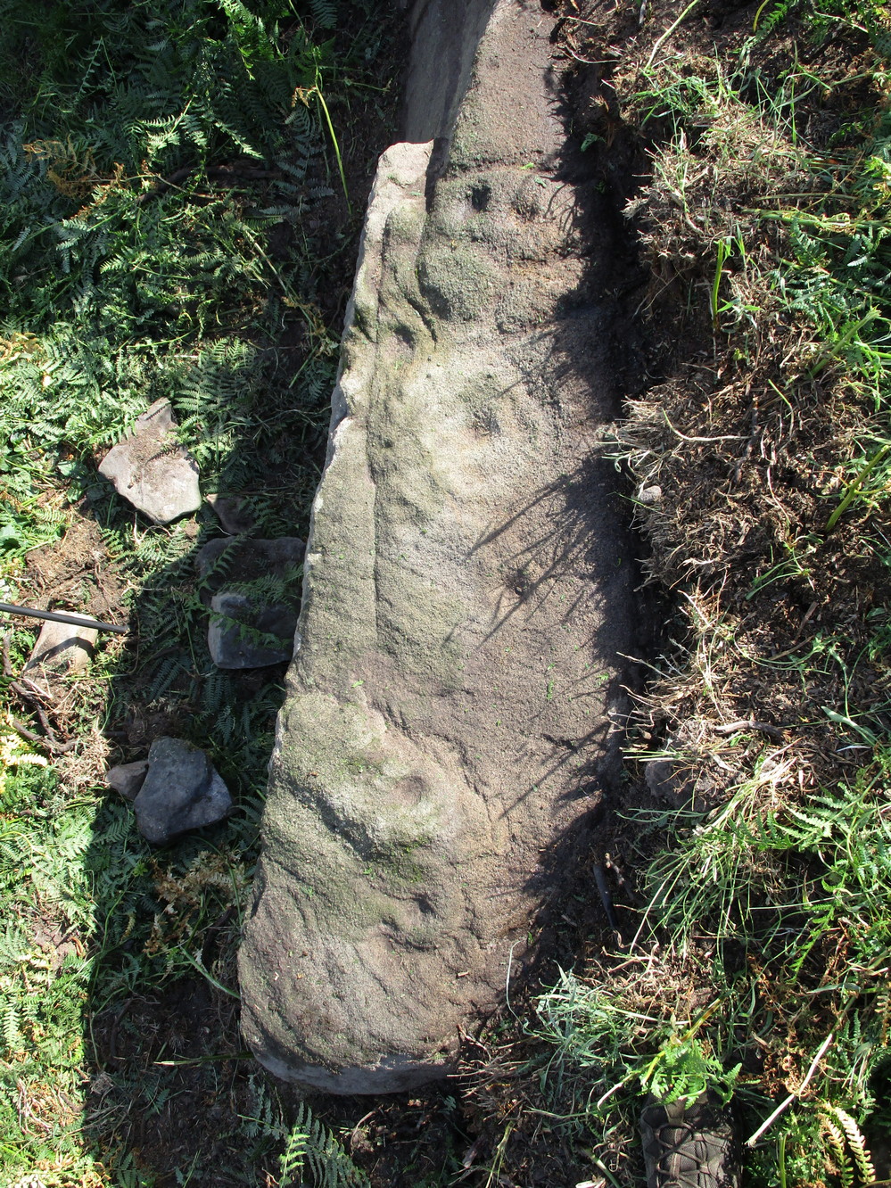
 The rock has been quarried into at same time in the past (just like the nearby Sunrise Stone), leaving us to wonder what the complete carving might have looked like. No doubt some pieces of it will be in the collapsed walling either side of the stone. All we have left to see are the two unfinished cup-and-rings above the natural cracks that give rise to the “ancestral being” appearance. The faint double cup-and-ring has curious linear arcs to its side, with two well-defined cups enclosed by two of them. It’s a nice-looking carving when the light is good. The petroglyph was carved over a long period of time, as evidenced by the differing levels of erosion in different sections of the design. It’s a common attribute. The oldest section is the faint double cup-and-ring, whose mythic nature was added to / developed at a much later date, perhaps even centuries later.


")
")
")
")
")

")


