Ringstone Edge, Barkisland, Ripponden, West Yorkshire

Ring Cairn:  OS Grid Reference – SE 04436 18247

Also known as:

  1. Ring of Stones
  2. Wolf Fold
  3. Wolf Stones

Getting Here

Site shown on 1854 map

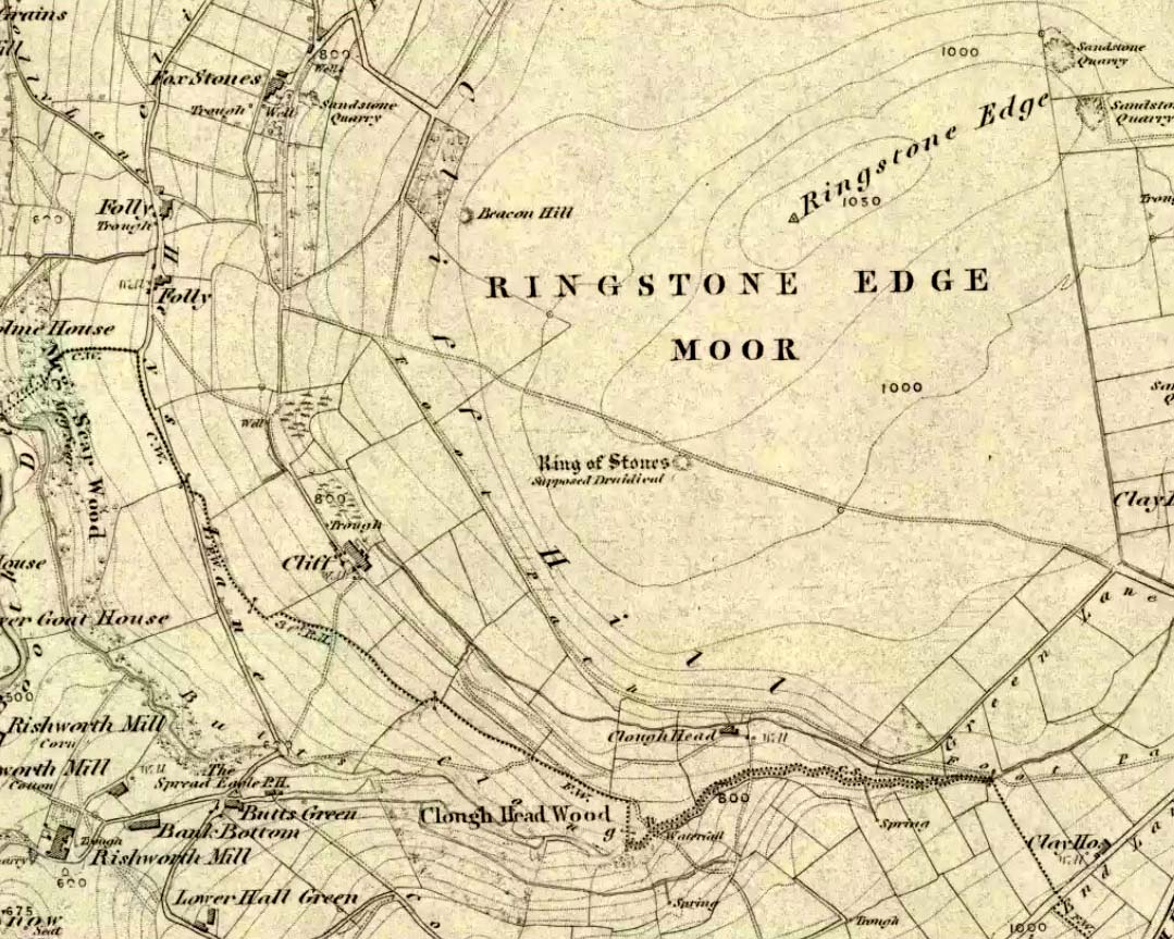
From Ripponden, taken the steep road up to Barkisland, but at the crossroads just before the village, turn right (south) and keep going for a mile till you reach the reservoir.  At the far-end of the reservoir, take the track down by its side and follow the footpath that bends round the edge of the grasslands.  Go up onto this small moorland and,  once you’re on the level, head towards where you’ll see a large pile of stones a coupla hundred yards away.  That’s it!

Archaeology & History

If we visit this site today, all we are left with is a scattered mass (or perhaps that should that be ‘mess’) of many hundreds of stones: the last remnants of what once would have been a proud circle of one form or another upon this small moorland plain.  Its significance was such that the very moor on which its remains are scattered, was named after it: the Ringstone Edge Moor.  But as with many sites from our megalithic period, this old place is but a shadow of its former self.

Artist’s impression of site (© Inmaculada Ibanez-Sanchez)

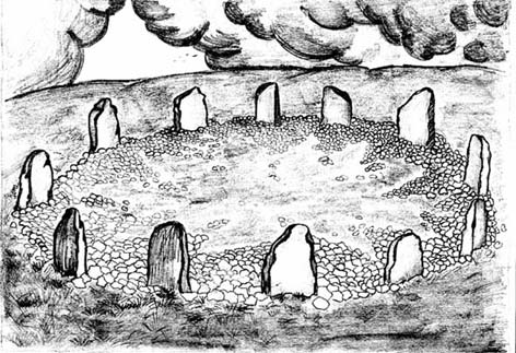
Gone are the upright monoliths which, tradition relates, once surrounded this low scattered circle of small loose stones (which would have made it look not unlike the wonderful stone circle of Temple Wood, Argyll). These standing stones were, so the folk record tells, removed near the end of the 18th century for use in some walling.

Described variously as a stone circle, ring cairn, cairn circle, an enclosure, and more, the site first seems to have been written about in 1775 by the great historian John Watson.  When he was vicar of the local parish in Halifax (not far from here) this “ring of stones” as he called them, was “called the Wolf-fold.”  Nearly one hundred years later, in F.A. Leyland’s superb commentary to Watson’s work, he wrote,

“The stones which constituted the circle at the time of their removal stood upwards of three feet…and the remain formed a striking object on the moor. The original number of stones of which the circle was formed is unknown, having long been in ruin and reduced in quantity before being finally removed. This was effected about twelve years since by the present tenant of the dam.” – that is, around 1859.

However, when Crabtree (1836) described the circle a decade or two earlier, he made no mention of such standing stones — although we must consider that Crabtree was very much like many modern academic archaeologists who tended to copy the works of others, much less than getting out in the field to see for himself.

At the beginning of the 20th century, the lore telling of the standing stones’ demise was repeated by local historian John Priestley (1903), when he said that: “all the large stones…were carted away about forty years ago” — that is, around 1863.

So it would seem that the very final destruction of the standing stones here, occurred sometime during the four year gap which Messrs. Leyland and Priestley describe.

More than fifty years later, Huddersfield historian James Petch (1924) came here to explore whatever remains he could find, and told:

“On top of a flat plateau on this moor, with an extensive view on all sides save on the north, where there is a gentle slope for some hundreds of yards up to the summit of the hill, there are distinct traces of a circular ring of small stones.  Pygmie flints have been picked up within a yard or two, but the only other fact to be noted about this earthwork is that there is a tradition to the effect that much earth has been removed from this site. It is not altogether impossible that this is a scanty remnant of a round barrow.”

This latter remark of Mr Petch seems most probable. The excessive scatter of small stones typifies the remains of many of the Pennine giant cairns, from the Little Skirtful on Burley Moor and giant tombs of the Black Hills near Skipton, to the similar monuments of our Devil’s Apronful, Pendle, etc, etc.

Close to this cairn circle, wrote Sidney Jackson (1968), there used to be the remains of an Iron Age settlement, “marked by wall foundations (but) is now covered by the waters of Ringstone Reservoir.”

Folklore

There is very little folklore that I’ve found here. Watson (1775) throws the usual idea that the place was a site of druidical worship; but other than that we only have a local Ripponden writer’s account, which told that there was once the ghost of a white lady that was once said to walk along the path somewhere between here and the Beacon Hill tumulus, a short distance to the north.

References:

  1. Abraham, John Harris, Hidden Prehistory around the North West, Kindle 2012.
  2. Bennett, Paul, The Old Stones of Elmet, Capall Bann: Milverton 2001.
  3. Burl, Aubrey, The Stone Circles of Britain, Ireland and Brittany, Yale University Press 2000.
  4. Crabtree, John, Concise History of the Parish and Vicarage of Halifax, Hartley & Walker: Halifax 1836.
  5. Jackson, Sidney, “Tricephalic Heads from Greetland, Yorks,” in Antiquity journal, volume 42, no.168, December 1968.
  6. Keighley, J.J., ‘The Prehistoric Period,’ in Faull & Moorhouse’s West Yorkshire: An Archaeological Guide to AD 1500, WYMCC: Wakefield 1981.
  7. Leyland, F.A. (ed.), The History and Antiquities of the Parish of Halifax by the Rev. John Watson, M.A., R. Leyland: Halifax n.d. (c.1867)
  8. Longbotham, A.T., ‘Prehistoric Remains at Barkisland,’ in Proceedings of the Halifax Antiquarian Society, 1932.
  9. Petch, James A.,  Early Man in the District of Huddersfield, Advertiser Press: Huddersfield 1924.
  10. Priestley, John H., The History of Ripponden, John Mellor: Ripponden 1903.
  11. Smith, A.H., The Place-Names of the West Riding of Yorkshire – volume 3, Cambridge University Press 1963.
  12. Watson, Geoffrey G., Early Man in the Halifax District, HAS: Halifax 1952.
  13. Watson, John, The History and Antiquities of the Parish of Halifax, T.Lowndes: London 1775.
  14. Whiteley, Hazel, Ryburn Tapestry, Halifax Evening Courier n.d. (c.1974)

© Paul Bennett, The Northern Antiquarian


Dun Dubh, Ford, Argyll

Dun:  OS Grid Reference – NM 8640 0479

Getting Here

From Ford village, take the track that goes uphill (west) running near the edge of the forest-line. Keep going until you hit the top of the forest and the large rocky hill above you (on your right) is where you need to be heading.  The rise to your left is Dun Chonallaich.  Walk around the bottom of the hill until you get to the other side (you should be 100 yards or more above the tree-line) where you’ll notice a ‘pass’ running west, with a rocky knoll above you on your right.  That’s it!

Archaeology & History

Thought to date from the Iron Age, the remains here cover an area 15 yards by about 25 yards.  Remains of walling around the edge of the summit nearly a yard wide in places define quite clearly where the ‘fort’ was centred.  The entrance to the site was found on the northwestern side.  In more recent times however, animal pens have intruded on the remains here and the archaeological remnants are much denuded.

Folklore

Samhain fires were lit on the larger ridge above this ruined fort until recent years, as some old local folk will tell you. These Halloween fires (done to celebrate the old New Year) were stopped a short time after the new ‘owner’ of the Auchinellan Estate (on whose land Dun Dubh is found) took exception to them and, for all intent and purpose, deemed them a fire hazard! The lady in question who inherited the Estate was in fact a devout christian who took exception to the local “pagan” goings-on, contrary to the beliefs of the previous Estate owner, who not only allowed such old events, but played a part in them.  Local folk hereabouts, not surprisingly, aint too keen on their part-time dictatorial christian neighbour.

The fires up here were also related to the linear cemetery at Kilmartin. Here the giant tombs all line up & point to Dun Chonallaich, behind which hides the more flattened top of Dun Dubh. When the Halloween fires were lit on top of this, the glow from behind the great pyramid of Chonallaich all the way down the Valley of the Kings, was spectacular!  One wonders just how long the local people had been doing this.  Quite a long time I imagine….

References:

  1. Royal Commission on the Ancient & Historical Monuments, Scotland, Argyll – volume 6, HMSO: Edinburgh 1988.

© Paul Bennett, The Northern Antiquarian


Slaithwaite Cross, West Yorkshire

Cross:  OS Grid Reference – SE 077 139?

Archaeology & History

The great Huddersfield historian, Philip Ahier (1948), in describing the lack of documentary evidence for several crosses in the neighbouring region, “at Deighton, Cowcliffe, Marsh and Golcar,” found out that,

“One did exist at Slaithwaite in front of the Manor House in the early past of the last century.  In March 1931, the base of this cross, commonly known as the Dial Stone, was removed to Doughlas in the Isle of Man, where it rested in the garden of Mr Harry Wood; in August 1939, it was brought back to Slaithwaite and now stands in the Recreation Park.”

However, this site differs from another two that I’ve found records for on the outskirts of this township.  Does anyone know what became of this old stone cross?  Izzit still about?  Its folk-name of the Dial Stone may make it a little easier to locate — but at the same time it does bring up the query, Why was it called that?

References:

  1. Ahier, Philip, The Story of the Three Parish Churches of St. Peter the Apostle, Huddersfield – volume 1, Advertiser Press: Huddersfield 1948.

© Paul Bennett, The Northern Antiquarian 


Boulter’s Barn Stone, Churchill, Oxfordshire

Standing Stone:  OS Grid Reference – SP 2938 2569

Also known as:

  1. Churchill Stone

Getting Here

Boulter's Barn standing stone, Churchill (Tom Wilson)
Boulter’s Barn stone (© Tom Wilson)

This stone stands on the south-side of the B4450 just north of the crossroads, halfway between Churchill and Chipping Norton.  Generally troublesome to see at first as it tends to get hidden in the hedgerow, so you may need to furrow into the but shrubbery to get to it, but it’s not too difficult to locate with a bit of patience.

Archaeology & History

This small standing stone seems to have been described for the first time in O.G.S. Crawford’s (1925) fine survey of the regions prehistoric remains following a letter he received from a local man, Mr A.D. Passmore, who first drew it to the attention of archaeologists.  Crawford told:

“This stone is a little over a mile southwest of Chipping Norton station.  It stands in the hedge on the northwest side of the road and is about four feet high… Nothing more is known about it, but it seems not unlikely that it may be of considerable antiquity.”

A few years later Leslie Grinsell (1936) mentioned it in his equally fine survey of prehistoric English tombs and associated remains, describing here, “a large stone which may be the remains of a megalithic monument.”  Tom Wilson then illustrated it in our crappy little Old Stones of Rollright (1999) work (which really needs updating and expanding).  It’s a cute little stone and may have once served as a companion to a prehistoric tomb as there are many others nearby.  It is also quite close to one of the local boundary lines and, p’raps, might once have served as a marker hereabouts.  We might never know…

References:

  1. Bennett, Paul & Wilson, Tom, The Old Stones of Rollright and District, Cockley: London 1999.
  2. Crawford, O.G.S., The Long Barrows of the Cotswolds, John Bellows: Gloucester 1925.
  3. Grinsell, Leslie V., The Ancient Burial Mounds of England, Methuen: London 1936.

© Paul Bennett, The Northern Antiquarian


Addlebrough (1), Thornton Rust Moor, North Yorkshire

Cup-Marked Stone:  OS Grid Reference – SD 948 879

Getting Here

This takes a bitta getting to and won’t really be worthwhile unless you’re a rock-art nut!  I s’ppose if you’re looking at the other decent cup-and-ring stones on the summit of Addlebrough, it might be worth looking at.  In which case, walk a coupla hundred yards southeast towards where the walling meets and climb over.  The walk a little further in the same direction and once you’ve gone less than 100 yards, look around.  You can’t really miss it if you potter about.

Archaeology & History

Single cup-marked stone (photo by Richard Stroud)

This possible single cup-marked stone appears to have been discovered before me ‘n Richard Stroud got to the spot, by none other than Stan Beckensall himself — or at least it’s in Stan’s Prehistoric Rock Art of County Durham, Swaledale and Wensleydale book, where he describes it as it only can be done: “a single possible cup-marked stone…SSE of the summit cairn”, which is where you find this. (Another single cup-marked stone found nearby by Barbara Brown aint the same one as this.)

References:

  1. Beckensall, S. & Laurie, T., Prehistoric Rock Art of County Durham, Swaledale and Wensleydale, County Durham Books 1998.

© Paul Bennett, The Northern Antiquarian


Netherurd Mains, Kirkurd, Peeblesshire

Cross:  OS Grid References – NT 1041 4403

Also Known as:

  1. Canmore ID 50098
  2. Swastika Stone

Archaeology & History

Swastika X, Netherurd
Netherurd’s Swastika Cross Stone

This supposedly 10-12th century carving — found in the early 1940s and handed to the Scottish National Museum in Edinburgh by Mr A. Sanderson — took my interest by virtue of the distinct swastika design carved on the face of the stone.*  The fact that it’s etched onto what’s thought to be the remains of an old christian cross shouldn’t be too surprising: we find it on numerous other old stone crosses, church bells and other religious remains.

This example was only carved on one side of the stone, which measures some 18-inches high and just 9 inches across.  The top of the stone has a design typical of many early crosses from between the 9th to 14th century; whilst the curvaceous line on the lower-right also typifies imagery found on many crosses from this period — some of which appear to be based on cup-and-ring imagery.  However, no such cup-and-rings seem to have been in evidence where this cross-remain was found.  Very little else is known about its history.

Although it aint quite as old as Ilkley’s Swastika Stone, this is still a fascinating carved stone indeed!

References:

  1. Royal Commission on the Ancient & Historical Monuments of Scotland, Peeblesshire – volume 1, HMSO: Edinburgh 1967.
  2. Stevenson, Robert B.K., ‘The Inchyra Stone and some other Unpublished Early Christian Monuments’, in PSAS 92, 1961.

* To those who don’t know, the swastika symbol has been used by people from around 20,000 BC onwards and has only very recently gained a bad press.  It’s a symbol that needs to be reclaimed, through education, and put back into its proper mythic place where it belongs – away from any Nazi dip-shits, whose retarded actions pale into insignificance when it comes to the primal archaic nature of this old form.

© Paul BennettThe Northern Antiquarian


Yarmer Head, Nidd, North Yorkshire

Standing Stone (destroyed):  OS Grid Reference – SE 299 612

Also Known as:

  1. Temple Yarmer

Archaeology & History

It was the legendary Harry Speight who described this in his monumental historico-topographical exploration of the Nidd valley in the 1890s.  Nothing else, it seems, has been said of the place, though something of considerable archaeological importance was once here.  Not only does he tell of the previous existence of “a large circular enclosure…the outer ditch having a circumference of nearly 1000 yards” at Yarmer Head, but,

“In the hollow on the east side of this hill was formerly a large natural marsh or lakelet, near which remains the base of an immense menhir or standing monolith, erected doubtless in heathen days to commemorate a great victory, or perhaps a treaty.”

The stone is not shown on the early OS-maps (although they did miss quite a lot of sites), and whatever its reason for being here might never be known as all traces of this giant monolith appears (yet again) to have vanished. There is an ancient boundary line immediately below the hill, on its eastern side, so perhaps the stone was an ancient marker along this.  Do any local folk round Nidd know owt more about this once important megalithic site?

References:

  1. Speight, Harry, Nidderdale and the Garden of the Nidd, Elliot Stock: London 1894.

© Paul Bennett, The Northern Antiquarian


Baldwin Stone, Silsden, West Yorkshire

Cup-Marked Stone:  OS Grid Reference – SE 06453 44658

Getting Here

Baldwin Stone - with its happy discoverer!
Baldwin Stone with its finder

From East Riddlesden, go up the road (over the swing-bridge) that takes you onto the moor-edge (ask a local if you have trouble).  Go all the way up till you hit the road which encircles the moor (it’s called the Silsden Road where you hit it).  Turn left for several hundred yards till you see the microwave tower just on the hillock to your right on Pinfold Hill (not the larger TV towers just below the forest).  Walk up there, then follow the edge of the walling till you hit the old Pinus sylvestris trees of Robin Hood’s Wood where 2 walls meet.  Go over the gate and walk to your right for about 200 yards, following the line of the walling.  You’re there!

Archaeology & History

Cluster of cups on southern edge
Cluster of cups on W edge

A newly-discovered cup-marked stone, located for the first time on Tuesday, June 9, 2009, by Michala Potts, who was out on an amble with some long-haired halfwit whizzing about getting excited about stupid cup-markings on stones, dragging her back and forth and leaving her in the middle of a bog!  On one occasion when this ‘ere fruitbat wandered off (again!), leaving her alone in the middle of the hills, she decided to check out some rocks a bit further up the slope where she’d been left alone.  And there, along the edge of some walling, right on the edge of the much-denuded Robin Hood’s Wood, a short distance west of Rivock, a curious stone popped out and caught her attention!

Was this a cup-marking she saw before her!?  It certainly was!  But she didn’t call out to this halfwit who’d left her to her own devices.  She let him just wander off to his sad heart’s content, whilst she got into the nitty-gritty of checking the stone out, uncovering the essentials of the carving while he bimbled off like a freak!  And what a nice carving it was she found…

Baldwin Stone - looking south
Baldwin Stone – looking west
First sketch of the stone

Although no accurate measurements were made of the stone (it was bigger than 10-inch!), at least 17 cup-markings were counted here: one singular and very well-preserved cup, alone on its southern edge, right by the walling.  But the main feature of the design is a cluster of cup-marks (at least 11) on the western side of the rock — one part of this cluster having the appearance of the figure 5 on a dice!  Several other well-defined cups occur on the central and more northern end of the rock.

Eventually, her sad stone-wandering fella returned, forlorn, having found no new carvings of his own (poor soul!).  And so she took his poor little hand, and took him to see the little prehistoric treasure she’s uncovered — and her sad little man got all smiley and … well, you know what they’re like!

Additionally however, for the archaeo’s amongst you: if you come wandering up here to check this carving out, you’ll notice the remains of many large upright stones in a lot of the old stone walls round here.  Many of these are the remains of Iron Age walling.

© Paul Bennett, The Northern Antiquarian 


Smoo Cave, Durness, Sutherland

Cave:  OS Grid Reference – NC 419 672

Getting Here

From Durness take the road east for a couple of miles till you see the signpost which takes you on the left-hand side of the road, down to the coast.  You can’t miss it!

Archaeology & History

Findings here allege to take the history of the place into the mesolithic period, but we don’t know this for sure.  An excavation here by a Mr Donald Macdonald of Sangobeg in 1904 uncovered the presence of several small bone pins, which seem consistent with Mesolithic finds elsewhere.  When archaeo-excavations were done here in 1982, human remains going back to at least Iron Age were found in the simple deposit of many shells.  A further analysis by the Glasgow Archaeology Unit in 1996 was prevented of some excavation by (get this!) those screwy Health & Safety regulations.  Here’s a definite case for an independent group to undertake work here, as we could ignore such preventative measures (and if we drown it’s our fault!).  Smoo Cave’s primary function is pretty obvious: it would have been used for both shelter and ritual. 

Folklore

The folklore here tells of magick and occultism and possible remnants of rites of passage lore. For herein, many centuries ago, a powerful land-owner called Lord Reay — reputed as a master in the black arts — battled with the devil in the Smoo Cave.

The devil was keeping watch on Lord Reay following a previous dispute between the two of them, and espied him as he entered the cave. As Alexander Polson told it, the cave

“consists of three caverns, one within the other. Lord Reay had got as far as the second, and his dog, which had gone on in advance, returned howling and hairless. By this, Lord Reay knew that Satan was there before him, and bravely waited the attack, which was soon made, and his lordship fought lustily. Happily at the opportune moment a cock crew. This frightened the devil and his attendant witches, but Lord Reay stood between them and the exit. In their fright they blew holes through the roof of the cave, and this is the origin of the two openings through which the Smoo burns fall.”

Pitch black cave; protective spirit animal; encountering one’s psychological nemesis; unconscious battles with Underworld forces; rebirth of the sun at cock-crowing time; the conquering of the dark forces and renewal of Lord Reay.  These are typical hallmarks probably signifying folk-remnants of shamanism and rites of passage, for which this cave may once have been used.

References:

  1. Polson, Alexander, Scottish Witchcraft Lore, W. Alexander: Inverness 1932.

© Paul Bennett, The Northern Antiquarian 

Druid’s Altar, Bordley, North Yorkshire

Ring Cairn:  OS Grid Reference – SD 94945 65270

Also Known as:

  1. Bordley Circle

Getting Here

Druids Altar on 1852 map

From Threshfield, go up Skirethorns Lane for about 1/2 mile, where the lane takes a sharp right. Continue uphill for nearly 2 miles to a metal gate. Go through the gate, where you’ll see a pair of curious standing stones ahead of you, but instead walk about 250 yards along the line of the old field wall running to the west.  You’ll see on the modern OS-map that a ‘cairn’ is shown: this is where you’re heading!

Archaeology & History

First highlighted on the 1852 OS-map of Bordley and district, this is a lovely site in a beautiful setting, surrounded by a veritable mass of other prehistoric remains at all quarters, including the large settlement of Hammond Close immediately south, the little-known settlement at Kealcup to the west, the Lantern Holes settlement up the hill immediately north, some standing stones due east, and much more.  Although it was described in Aubrey Burl’s Four Posters (1988) as just such a type of megalithic relic (a “four-poster stone circle”), an earlier description of the site from the mighty pen of Harry Speight (1892) told of a much more complete ring of stones, with trilithon to boot. He wrote:

“This prehistoric relic consists of a round stone and earthen mound, about 150 feet in circumference and 3 feet high, and was formerly surrounded by a circle of upright stones, only three of which are now left standing. On one side was a large flat stone resting upon two others, and known as the Druid’s Altar. On the adjoining land an ancient iron spear-head was found some years ago, and fragments of rudely-fashioned pottery have also from time to time turned up in the same neighbourhood.”

Edmund Bogg’s (1904) description following his own visit a few years later described this “remains of Druidical sacrifice” as consisting of,

“a mound some four feet high, and fifty yards round the outer rim. In the centre are two upright stones about four feet in length; and others nearly buried in the mound. Numerous stones from this circle have been used in building the adjoining walls.”

Bordley Circle, looking SE
Bordley Hill, looking south to Pendle Hill

A decade later another writer (Lewis 1914) merely copied what Speight and Bogg had recited previously. And whatever the modern books might tell of its status, I think we can safely assert that this was originally a much more substantial monument than the humble four-poster stone circle that meets our eye nowadays.  Our megalithic magus, Aubrey Burl (1988), wrote the following on Bordley’s druidical stones:

“On a circular mound 41ft (12.5m) across and 3ft (1m) high, three stones of local limestone form the corners of a rectangle 11ft 6in (3.5m) square, from which the SW stone is missing.  At its corner is ‘a stump, possibly the base of a prostrate stone,’ 5ft 10in (1.8m) long, now lying near the centre.  The tallest stone, 3ft 7in (1.1m) high is at the south-east.  The sides of the square are close to the cardinal points.  Between the SW and SE stones is a scatter of round cairnstones… Characteristically, the 4-Poster stands at the edge of a terrace from which the lands falls steeply to the west.”

Plan of the Druid's Altar (after Burl, 1988)
Plan of the Druid’s Altar (after Burl, 1988)

The Druid’s Altar seems to have originally been a large prehistoric tomb, perhaps even a chambered cairn.  Its situation in the landscape where it holds a circle of many outlying hills to attention, almost in the centre of them all, was evidently of some importance.  The only geographical ‘opening’ from here is to the south, where a long open valley widens to capture the grandeur of Pendle Hill, many miles away.  This would not have been insignificant.

We must also draw attention to what may be a secondary tumulus of similar size and form to the mound that the Druid’s Altar sits upon only some 25 yards to the west of the “circle”.  The shape and form of this second mound is similar to that of our Druid’s Circle — though to date, it seems that no archaeologist has paid attention to this secondary feature.  It measures some 21 yards (east-west) x 19 yards (north-south) in diameter and has the appearance of a tumulus or buried cairn.  The mound may be of a purely geological nature, but this cannot safely be asserted until the attention of the spade has been brought here.

Druid's Altar, Bordley (drawing by Neil Wingate, 1976)
Druid’s Altar, Bordley (drawing by Neil Wingate, 1976)

Folklore

Although we have nothing directly associated with the circle, the surrounding hills here have long been known as the abode of faerie-folk.  Threshfield — in whose parish this circle lies — is renowned for it.  There have been accounts of curious light phenomena here too.  Modern alignment lore tells the site to be related to the peaked tomb above Seaty Hill, equinox west of here.

References:

  1. Bogg, Edmund, Higher Wharfeland, James Miles: Otley 1904.
  2. Burl, Aubrey, Four Posters: Bronze Age Stone Circles of Western Europe, BAR 195: Oxford 1988.
  3. Feather, S.W. & Manby, T.G., ‘Prehistoric Chambered Tombs of the Pennines,’ in Yorkshire Archaeological Journal, Vol 42, 1970.
  4. Lewis, A.L., ‘Standing Stones and Stone Circles in Yorkshire,’ in Man, no.83, 1914.
  5. Raistrick, Arthur, ‘The Bronze Age in West Yorkshire,’ in Yorkshire Archaeological Journal, Vol 29, 1929.
  6. Speight, Harry, The Craven and Northwest Yorkshire Highlands, Elliott Stock: London 1892.
  7. Wingate, Neil, Grassington and Wharfedale, Grassington 1977.

© Paul Bennett, The Northern Antiquarian