Beamsley Beacon, Beamsley, North Yorkshire

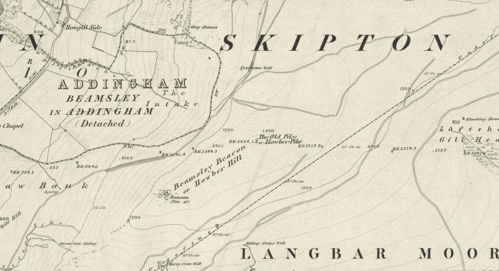
Cairn:  OS Grid Reference – SE 09891 52435

Also Known as:

  1. Howber Hill

Getting Here

Beamsley Beacon, looking NW

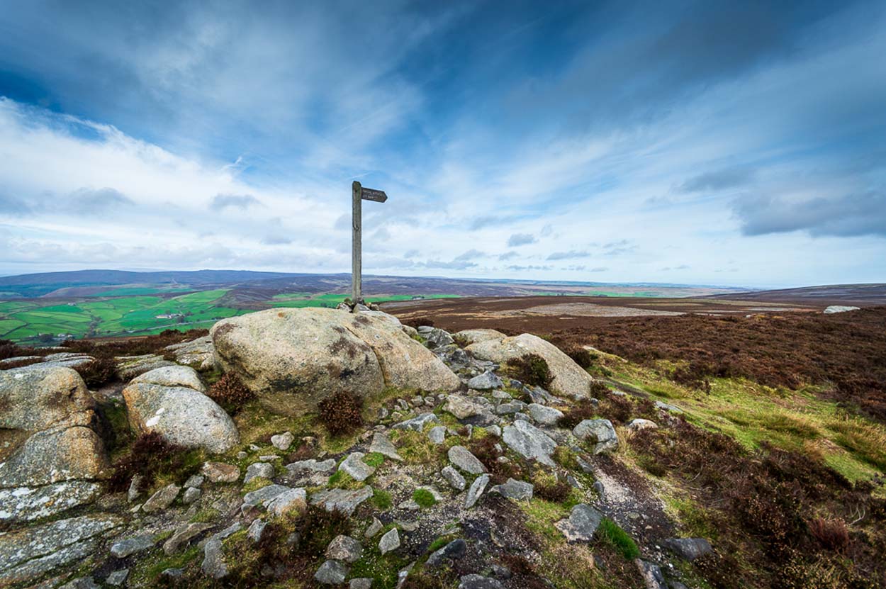
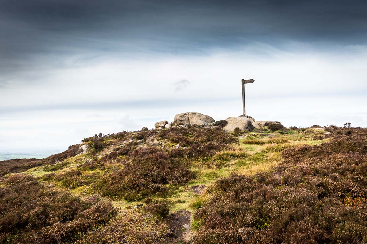
If you’re coming via Ilkley, cross the bridge to Middleton and turn left, following the long winding road for several miles until you hit Langbar village.  If you’re coming via Bolton Bridge, go to Beamsley village and turn left up Lanshaw Bank until you hit Langbar village.  Whichever of the two routes you use: on the north side of Langabr village is a distinct small rough car park.  From here, cross the road where the footpath sign is and walk straight up the steep hill to Beamsley Beacon at the top.  You can’t miss it!

Archaeology & History

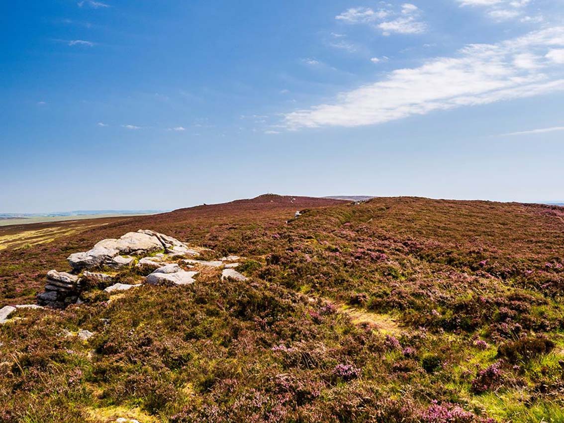
At the highest point on these hills, 1300 feet up, we come across this ancient prehistoric cairn.  Its position in the landscape is impressive to say the least, being visible from nearly every direction on the moorland heights for many miles around, as well as being conspicuous from the riverlands below.  A visit to the site nowadays shows it surmounted by a more recent mass of small stones turning it into a large walker’s cairn with only its compact base showing any real sign of antiquity.

Site shown on 1853 map
Western side of the cairn

Mentioned briefly in parish records from 1658 onwards, it was highlighted on the earliest OS-map as simply a Beacon hill, due to it being used for beacon fires.  We’re not certain when its beaconesque function first came about; and, it’s possible, that its beacon element could have replaced a much earlier heathen fiery function, typical of many hilltop sites up and down this and other countries.  But we do know that such fires were lit here at the beginning of the 19th century.  The great Harry Speight (1900) told that of its

“use as a prospecting-point and beacon there is no doubt.  In the Bolton Abbey registers, under date 1803, is this entry:

“Apprehensive of a French invasion, Beamsley Beacon was put in a state of repair, and four people appointed to watch it.  About — of the inhabitants of this chapelry inrolled themselves as Volunteers, the whole number of whom in Craven amounted to 1,200 Infantry and 200 Cavalry.  A Sergeant was appointed to drill the volunteers of this chapelry at Bolton.”

The beacon at this time received light from Pinhaw on Carlton Moor and sent it forward to Otley Chevin, as appears by an old chart at Wakefield, dated 1803.”

Photo by James Elkington

The beacon’s ancient name of Howber Hill is literally the Hill of Tombs, as derived from the Teutonic haugr, and Anglian how, being a burial mound; and berg is a hill, sometimes fortified.  Whilst there seems to be no evidence of ancient fortification, compacted cairn material at the base seems to confirms the -how element.  Yet despite Speight citing this etymology, he was was somewhat sceptical wondering, instead, if the site was merely a giant boundary marker—which it has been for centuries.

A short distance along the footpath to the east is the denuded old cairn known as The Old Pike.  Further east still, along the same boundary line, there was once another old tomb, long since gone…

Folklore

I’m not sure whether this should gone in the folklore section or not.  But, well, it’s here nonetheless!  In Guy Phillips’s (1976) book on the mythic history of ancient Brigantia, he describes a number of alignments, or leys (not one of those stupid energy lines, which has nowt to do with leys)—one of which crosses Beamsley Beacon.  It’s an west-east line that begins at Cockerham and from there goes,

“through Top of Blaze Moss SD 619525, Slaidburn (it is very clear here), Flambers Hill SD 877523, southern edge of Copy Hill 952523, Draughton (extremely clear), Beamsley Gibbeter and Beamsley Beacon, Heligar Pike, Scow Hall 203523, Little Almscliffe Crag, Tockwith church and on to the coast.”

I have to say that I’m sceptical of the veracity of this alignment.

References:

  1. Bogg, Edmund, Higher Wharfeland, James Miles: Leeds 1904.
  2. Cobley, Fred, On Foot through Wharfedale, William Walker: Otley 1880.
  3. Phillips, Guy Ragland, Brigantia – A Mysteriography, RKP: London 1976.
  4. Smith, A.H., English Place-Name Elements – volume 1, Cambridge University Press 1956.
  5. Smith, A.H., The Place-Names of the West Riding of Yorkshire – volume 5, Cambridge University Press 1963.
  6. Speight, Harry, Upper Wharfedale, Elliott Stock: London 1900.

Acknowledgements:  Huge thanks to James Elkington for use of his photo on this site profile.  Cheers mate. 😉

© Paul BennettThe Northern Antiquarian

The Old Pike, Beamsley, North Yorkshire

Cairn:  OS Grid Reference – SE 10226 52648

Also Known as:

  1. Howber Pike

Getting Here

T’ Old Pike on t’ 1853 map

I prefer the much longer walk to this site, from Askwith Moor carpark some 5 miles to the west, but this wouldn’t be most folks cuppa tea.  So for the lazy buggers amongst you: whether you’re coming via Ilkley (cross the bridge to Middleton and turn left, following the long winding road for several miles) or Bolton Bridge (hit Beamsley village and turn left up Lanshaw Bank), you need to get up to Langbar village. On the north side of the village is a distinct small rough carpark. From here, cross the road where the footpath sign is and walk straight up the steep hill to Beamsley Beacon at the top.  Keep walking for exactly ¼-mile where you’ll find a large heap with boulders round its edge. You’re there.

Archaeology & History

Skyline peak of T’ Old Pike (photo by James Elkington)

At the highest point of these hills where the moorlands of Langbar and Beamsley meet, is this prominent rocky pile on the same skyline as Beamsley Beacon.  The two are ancient cairns, both robbed of most of their stones, but still a good site to sit and behold the vast landscape which reaches out for miles in all directions.  And, from this highest point, looking south to the highest point across the Wharfe valley on Ilkley Moor, the remnants of another giant prehistoric cairn is visible: looking across at each other, eye to eye.

Of the two great cairns on Beamsley moor, The Old Pike is the more peculiar of the two because—unlike its partner along the ridge—several large boulders near its top give the impression of being Nature’s handiwork.  This may be the case, but Nature isn’t the lass who laid down the mass of smaller rounded stones that are mainly visible on the west and southern sides.  These have been placed there by people.  But it’s not until you step back 40 or 50 yards that you get a more distinct impression of the place.  The Old Pike rises up like a rocky nipple out of the heath, showing a very embedded overgrown man-made heap, typical of the overgrown prehistoric cairns that scatter our northern uplands.

Looking north (photo by James Elkington)
The piled heap (photo by James Elkington)

The site is included on the archaeologist’s Pastscape website, albeit citing it as a ‘possible’ cairn.  But the more we look at it, the greater the impression becomes that this old heap is man-made – certainly on its eastern and southern sides.  The rise of boulders on its west may be natural, and then ancient man placed the cairn material up and around them.  Only an excavation would tell us for sure.  But its old name of Howber Pike tells a tale before we even visit the place.  When the great Yorkshire historian Harry Speight (1900) came here he picked up on this element, telling us,

“Howber literally is the ‘Hill of Tombs’, from the Teutonic haugr and Anglian how, a burial mound, and berg also her, a hill, often fortified.”

The great place-name authority A.H. Smith (1956) not only echoes this but goes into greater etymological detail, noting that as well as haugr or how being “an artificial mound, a burial mound,” it’s a word that is particularly used in the northern counties.  He does note however, that this may not always be the case and can sometime just relate to a “a hill or hilltop resembling an artificial mound.”  However, we also find in Smith’s tome on place-name elements that the latter part of ‘Howber’ deriving from beorg, can also mean a tumulus or burial mound.  But there are cases where this has been corrupted and means, as Speight states, a fortified hill.  So at Howber Pike we seem to have the ancient name of some probable burial site.  As for its neighbour a quarter-mile west, the giant cairn of Beamsley Beacon is also known as the Howber Hill….

References:

  1. Smith, A.H., English Place-Name Elements – volume 1, Cambridge University Press 1956.
  2. Smith, A.H., The Place-Names of the West Riding of Yorkshirevolume 5, Cambridge University Press 1963.
  3. Speight, Harry, Upper Wharfedale, Elliott Stock: London 1900.

Acknowledgements:  Huge thanks to James Elkington for use of his fine photos on this site.

© Paul BennettThe Northern Antiquarian


Round Hill, Middleton Moor, North Yorkshire

Tumulus:  OS Grid Reference – SE 107 509

Also known as:

  1. Black Hill tumulus

Getting Here

Round Hill tumulus, Middleton Moor

From Ilkley town centre, taken the road north across the River Wharfe, turning left and up the country lane towards Nesfield.  As you’re driving with the farmed fields on either side, you’ll go round a couple of swerves in the lane and reach the open moorland on your right, just past the small copse of trees on the same side.  There’s a small place to pullover on the right 100 yards on and walk up the footpath running northeast onto the moor.  Go past the disused quarry and up further till you reach the rounded hill where the tumulus stands.

Archaeology & History

On the moors north of Ilkley – as shown on OS-maps since the 1850s – on the southeastern edge of Middleton Moor, is this singular tumulus, a short distance west of some old quarrying at the curiously-named Lurgy Delf.  The small hill is easy to find and appears at the western edge of a whole host of neolithic and Bronze Age remains.  It is included as a boundary marker between Middleton and Langbar, as marked by an old stone on its southern side.  Eric Cowling (1946) described this as “a spread of stones on Round Hill” in the same context as other burial mounds and cairns in the region, also naming it as the Black Hill tumulus.  Many flints had been found all round here and it stands at the western edge of a great number of cup-and-ring stones, stretching eastwards across the moors for several miles.  To my knowledge, no excavation has taken place here.

References:

  1. Cowling, Eric T., Rombald’s Way, William Walker: Otley 1946.

© Paul Bennett, The Northern Antiquarian


Middleton Moor Carving (447), North Yorkshire

Cup-and-Ring Stone:  OS Grid Reference – SE 10931 51278

Getting Here

Follow the same directions as to reach the so-called Smiley Stone carving and look just 10 yards SE.

Archaeology & History

About 10 yards away from the Smiley Stone is another of Middleton Moor’s ‘dubious carvings’ to me. I remember seeing the drawing of this years back, perhaps a decade after Stuart Feather first described it (1966) and remember thinking it looked a bloody good carving. But when I saw it for the first time in February 2005 with Richard Stroud, not only could I hardly see what was supposed to be there, but once I’d seen the alleged design, some doubt came over me regarding its archaic nature. That doubt still remains.

Faint cups & lines
Design on carving 447

There certainly seems to be a few faded cup-marks on the stone — which looks to be broken from a larger, circular worked stone of a much more modern age (an old mill stone perhaps?) — but the lines which both Feather and the grand pair of Boughey & Vickerman (2003) copy into their survey, are all too vague and certainly not ancient in my book.  Perhaps some local folk were still etching cup-marks and lines onto stones into the medieval period and later, like the ones found on the Churn Milk Joan monolith near Hebden Bridge…

References:

  1. Boughey, Keith & Vickerman, E.A., Prehistoric Rock Art of the West Riding, WYAS: Leeds 2003.
  2. Feather, Stuart, “Mid-Wharfedale Cup-and-Ring Markings, no.47: Middleton Moor, Ilkley,” in Cartwright Hall Archaeology Gorup Bulletin, 11:9, 1966.

© Paul Bennett, The Northern Antiquarian


Middleton Moor Carving (448), North Yorkshire

Cup-and-Ring Stone:  OS Grid Reference – SE 10931 51276

Getting Here

CR-448 general design

From the back of Moor End Farm on the south-side of Langbar village, follow the Long Ridge footpath up onto the moor. Walk along the path until its starts dipping down again, onto the moor proper and where another footpath crosses and goes down into the small valley of the Dryas Dike stream: follow it down, crossing the stream and up the small slope till you’re on the next level of ground.  Stop here and walk right, off-path and up the gentle slope towards a small fenced-off piece of moor.  About 30 yards before the fence, check out the rocks under your noses.  You’re damn close!

Archaeology & History

If you’re gonna come up this region, this is the carving you’ll most wanna check out.  It’s the most ornamented of all the cup-and-ring stones at the top of Delves Beck.  Comprising at least five full cup-and-rings and a number of single cups, carved on a roughly square flat rock, it was first found by Stuart Feather in the mid-1960s.  It sits amidst a cluster of many other carvings on the same ridge.  This (for me at least) is something of a curiosity, inasmuch as we have a seeming lack of other prehistoric remains in attendance.

Carving 448 with paint damage
…and again, with paint damage

On the other side of the Wharfe valley above Ilkley, aswell as where we find cup-and-ring clusters on the Aire valley side at Baildon and East Morton, a preponderance of burials tend to cluster around clusters of rock art; but this doesn’t, initially, seem evident here.  A possible cairn is located on the northern side of this small ridge, and there is distinct evidence of another cairn down the slope on the other side of the Dryas Dike stream (by stone 440) just 100 yards away, but that’s it.  A more thorough examination of this region is required to see if other burial remains were in evidence hereby in the past.  I have photos of seemingly cairn-scatter material, and ancient walling in is clear evidence on the northern side of Dryas, but much more work needs doing.  Obviously much of this would require full surface excavation, which means we’re gonna need quite a bit of work and effort to see if the rock-art/burial patterns found elsewhere are echoed here.  It’s likely, it’s gotta be said.

…On a slightly more disturbing note: when me and Dave were up here last week, this carving and several others with more ornate designs on this ridge (carvings 446, 453 and others) had been painted over in some black substance.  You can see this clearly in the photos we took, above.  Whoever did it appears (word gets to me that a arty-dood called Paul did it) has done so to highlight the carvings so they stand out very clearly.  If you wanna highlight carvings for better images or photos, there are much better ways of bringing out the designs than the methods you employed there: chalk for one!

References:

  1. Boughey, Keith & Vickerman, E.A., Prehistoric Rock Art of the West Riding, WYAS 2003.
  2. Feather, Stuart W., “Mid-Wharfedale Cup-and-Ring Markings: Nos 43 & 44, Middleton Moor,” in Cartwright Hall Archaeology Group Bulletin, 11:4, 1966.

© Paul Bennett, The Northern Antiquarian 


Middleton Moor Carving (449), North Yorkshire

Cup-Marked Stone:  OS Grid Reference – SE 10935 51309

Getting Here

Follow the same directions to find the Middleton Moor carvings of 441, 445, or others close by.  If you can get to carving 445, then you’re about 20 yards northeast away from this one!  A bittova upright stone, with another undecorated smooth flat rock about one-foot away.

Archaeology & History

Amidst the clump of other carvings on top of the ridge at the head of Delves Beck on the southern side of Dryas Dike, is this small standing-stone-like rock, which has a distinct single cup-marking right on the topmost part of the stone.  In certain lighting conditions it seems that there may have been a partial surrounding-ring on its top, or perhaps a smaller faded cup by its side.  It’s hard to tell — so let’s play safe and just stick with it being a single-cup stone for the time being!

References:

  1. Boughey, Keith & Vickerman, E.A., Prehistoric Rock Art of the West Riding, WYAS 2003.

© Paul Bennett, The Northern Antiquarian


Middleton Moor Carving (445), North Yorkshire

Cup-Marked Stone:  OS Grid Reference – SE 10917 51299

Getting Here

Follow the same directions to find Middleton Moor’s 441 carving.  Then, go across the small stream a bit further down the slope and up up the slope until you’re on the level.  Once on this small rise in the land, look up the slight slope where approaching the the fenced area.  You’re close!

Archaeology & History

Middleton Moor carving 445

On the Middle Ridge between the streams of Delves Beck and Dryas Dike, this small rounded triangular-shaped carved stone has eight simple cup-markings eroded, but notable on its smooth surface.  Boughey & Vickerman (2003) suggest some may be gunshot marks, which has to be considered at several of the seeming ‘cup-markings’ on this moor. (particularly at Carving no.440 less than 100 yards away)  Archaeo-astronomers amongst you will note the Cassiopeia-like central design on this design — though this is probably coincidental (it might have tickled mi fancy when I was going thru my astroarchaeology phase many years back, but not anymore).

References:

  1. Boughey, Keith & Vickerman, E.A., Prehistoric Rock Art of the West Riding, WYAS 2003.

© Paul Bennett, The Northern Antiquarian


Caspar Stone, Middleton Moor, North Yorkshire

Cup-Marked Stone:  OS Grid Reference – SE 10879 51405

Archaeology & History

Caspar Stone drawing © M.Short & R.Stroud
Caspar Stone unearthed © M.Short & R. Stroud

This carving was discovered very recently following an exploration of recognised sites on Middleton Moor by rock art student Mike Short on March 28, 2010.  Found amidst a cluster of other carved rocks, it was located after he noticed a small piece of stone poking out of the peat and — as happens to those folk obsessed by these ‘ere carvings — he decided to dig round the stone and cut the turf back to see if there was anything carved on the rock, as there are other cup-and-rings are close by.  Thankfully, after a bit of effort digging round the stone, Mike found the carving we see in the images here! (courtesy of Mike and Richard Stroud).   With a distinctly ‘facial’ appearance (hence the name), the following notes were written describing the new find:

“Small roughly oval dome-shaped medium grit rock approx. 49cm X 36cm, at and below soil level. Two cups, one of which is conical and deep (55mm deep and 65-75mm diameter) and of similar profile to one of the cups on No. 458; small shallow bowl-like depression with possible peck marks; curving groove on northern edge.”

When Mike finished with their drawings and measurements, the stone was covered back over and left in situ.  Although I aint seen the carving ‘in the flesh’ misself yet (we’re gonna have a look next week) it gives me the impression it had some association with burials.

References:

  1. Short, Mike & Stroud, Richard, “Report of New Carved Rock (‘Caspar’) on Middleton Moor,” April 2010.

© Paul Bennett, The Northern Antiquarian


Middleton Moor Carving (441), North Yorkshire

Cup-and-Ring Stone:  OS Grid Reference – SE 10887 51381


Getting Here

From the back of Moor End Farm on the south-side of Langbar village, follow the Long Ridge footpath up onto the moor. Walk along the path until its starts dipping down again, onto the moor proper and where another footpath crosses and goes down into the small valley of the Dryas Dike stream, follow it – though only for about 75 yards, heading diagonally into the heather slowly towards the stream.  You’re getting close!

Archaeology & History

Crude drawing of CR441

Yet another small carving found amidst a decent cluster of cup-and-rings and other archaeological remains near the top of Dryas Dike, this stone was first described in the Boughey & Vickerman (2003) survey.  It’s located about 10 yards below Middleton Moor CR-440, above the stream of Dryas Dike.  It’s a simple design, comprising of a central groove with a cup at either end and several other cups either side of this central line.  (cheers to Richard Stroud for use of his photo).

References:

  1. Boughey, Keith & Vickerman, E.A., Prehistoric Rock Art of the West Riding, WYAS 2003.

© Paul Bennett, The Northern Antiquarian


Spring Stone Carving, Middleton Moor, North Yorkshire

Cup-Marked Stone:  OS Grid Reference – SE 11611 51610

Also Known as:

  1. Middleton Moor carving 483 (Boughey & Vickerman)

Getting Here

From Ilkley go up to Middleton and from there go up Harding Lane and, where the road bends left a track goes straight north onto the moors. Go up this until you’re onto the moor proper. Keep going until you’re following the line of walling, where a small stream is trickling right by your right-hand side. Follow this to its source a coupla hundred yards up. Stop!

Archaeology & History

Middleton Moor CR483: single cup-and-line

First mentioned by Stuart Feather in 1965, this simple cup-marking has a long line squirming away to the edge of the rock on which it’s carved.  The cup-marking is some 3 inches across and about ½-inch deep, with the long line about 24 inches long.  There’s really nowt much to look at here unless you’re a real cup-and-ring freak — though note that the carving occurs on a broken piece of stone just where a spring of water emerges from the ground.  Some archaeo’s have a notion that sometimes our cup-and-ring stones have some sorta relationship with water — though they’re not into sticking their necks out and saying anymore than that!  And of course, some carvings obviously relate to water. This one here is a strong contender, with the long wiggly line perhaps representative of the stream running from its source, which itself is the cup-mark.

However, we might just aswell surmise that the carving here was executed by some bored teenager, just testing out his first antler pick, or flintstone, telling his mates, “I woz ‘ere!”

References:

  1. Boughey, Keith & Vickerman, E.A., Prehistoric Rock Art of the West Riding, WYAS 2003.
  2. ather, Stuart, ‘Cup and Ring Boulders,’ in the Cartwright Hall Archaeology group Bulletin, 10:7, July 1965.

© Paul Bennett, The Northern Antiquarian