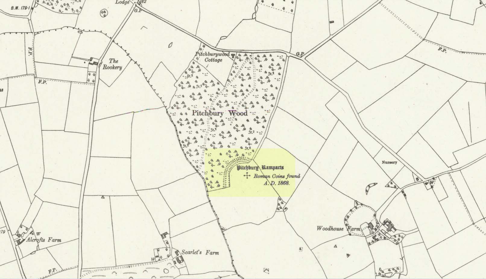
Along the A134 in Horkesley Heath, turn west along Coach Road and after a half-mile where it veers right, keep going for another half-mile where you’ll reach the woodland on your left. A path goes into the trees just before Pitchbury Lodge. Go along here and near the very far (southern) end of the trees, just before the open fields, you’ll see the large undulating ramparts of earth. Keep your eyes peeled. You’ll see them!
Archaeology & History
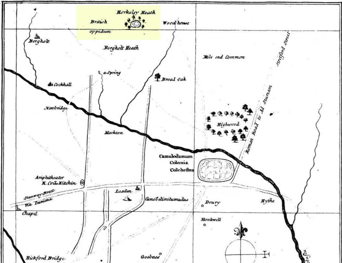
Stukeley’s 1759 map
This once large hillfort was described in the Colchester township perambulations of 1671 and cited in Philip Morant’s classic work. (1748) He told how the boundary line ran “under Chesterwell along the Rampiers by Horkesley Heath,” and which P.H. Reaney (1935) tells was our wooded hillfort. In Morant’s day, the place was all but complete and so would have been well recognised by local people. Certainly it came the attention of the great antiquarian William Stukeley who, in 1759, came to Colchester and met with Morant. Stukeley mainly surveyed the area south of here, at Lexden Heath, but one of his sketch maps clearly highlighted a place he called “a circular work on Horkesley Heath”, i.e., Pitchbury Rings. The site seems to have remained relatively intact until the middle of the 19th century when a local land-owner took it upon himself to plough over and vandalise much of the site, leaving only a small proportion of the earthworks that we can still see to this day.
The ruins were described in I.C. Gould’s (1903) piece for the Victoria County History, where he told, at Great Horkesley,
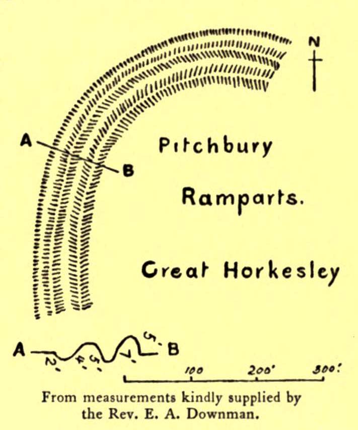
Gould’s 1903 sketch of the remainsRoyal Commission’s 1923 ground-plan
“are some remains of an earthwork known as ‘Pitchbury’ or ‘Pitsbury Ramparts.’ When the late Rev. Henry Jenkins described the camp in 1841, he stated that it was of oval shape, and contained about 6 acres. Most of it was levelled for agricultural operations about fifty years ago, but there are still some remains, consisting of two banks with their accompanying ditches. The lines moreover of that part which was destroyed, can be partially traced in the adjoining fields.”
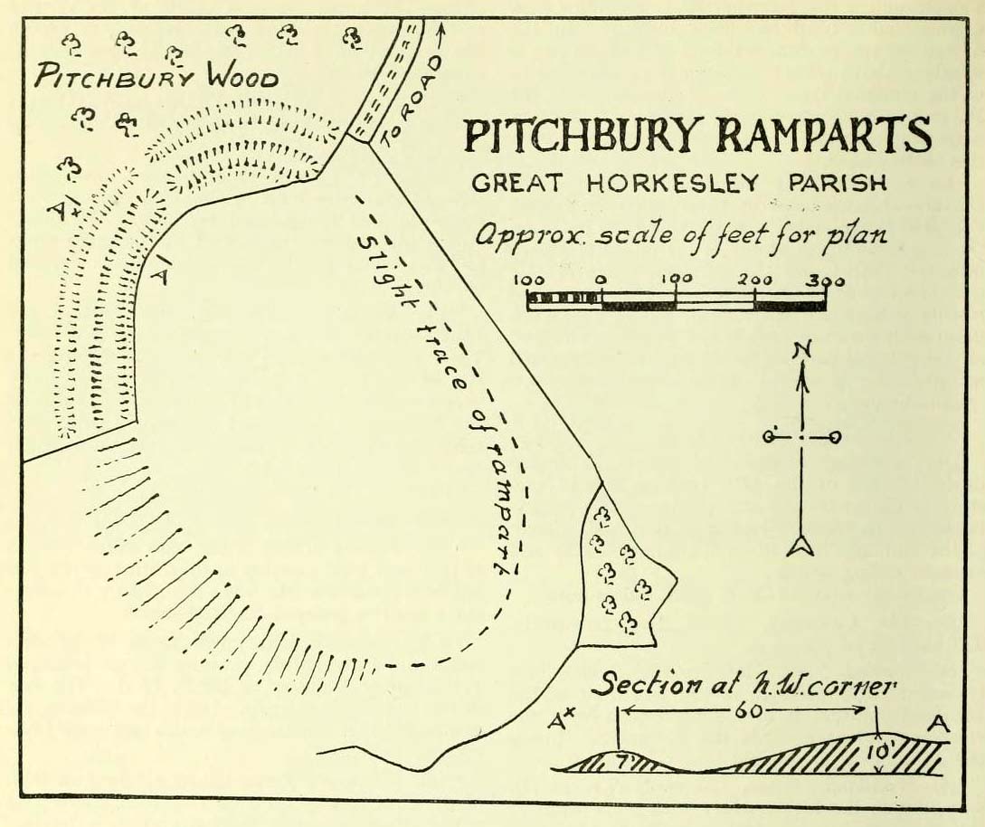
When the Royal Commission (1922) doods wrote about the site nearly twenty years later, things hadn’t changed too much and they simply reported how the “ramparts have nearly disappeared, except for the north section.” In this “imperfect” condition, as they called it, they gave the following brief description:
“Pitchbury Ramparts, in Pitchbury Wood, about 2 mile south of the church, are the north end of a large camp, roughly oval in shape, and defended by a double rampart and ditch. The defences are well preserved in the wood, the inner rampart being 10 ft. above the ditch, which is 60ft wide from crest to crest, but the greater part of the work has been almost obliterated by the plough, and is now only faintly discernible in a large field S. of the wood. The camp appears to have been 800 ft. long and 600 ft. wide.”
Thankfully there seems to have been no real increase in damage to the site since then. It was excavated in some detail in 1933 and again in 1973 and the finds were published by the highly reputable Colchester Archaeological Trust, whose subsequent report by Hawkes & Crummy (1995) is required reading for anyone wanting to know the detailed archaeology of this and other sites in the area.
Folklore
An intriguing piece of folklore was described in John Round’s (1882) history of the early battles around Colchester Castle. During the time when the Roman Empire was starting to crumble, the great Pictish tribes of Scotland ventured here and, we are told, took control of the Pitchbury Rings where they stayed before attacking Colchester Castle.
“Traces have been discovered of some violent catastrophe, possibly the first capture of the Colony by the marauding Picts from the North. Allured, in one of their Southern raids, by the wealth of the goodly Colony, they swooped down like eagles on their quarry from the wooded heights of ‘Pictsbury’.”
References:
Gould, I. Chalkley, “Ancient Earthworks“, in Victoria History of the County of Essex – volume 1, Archibald Constable: Westminster 1903.
Reaney, P.H., The Place-Names of Essex, Cambridge University Press 1935.
Watson, J.Y., Sketches of Ancient Colchester, Benham & Harrison: Colchester 1879.
Acknowledgements: Big thanks for use of the 1st edition OS-map in this site profile, Reproduced with the kind permission of the National Library of Scotland.
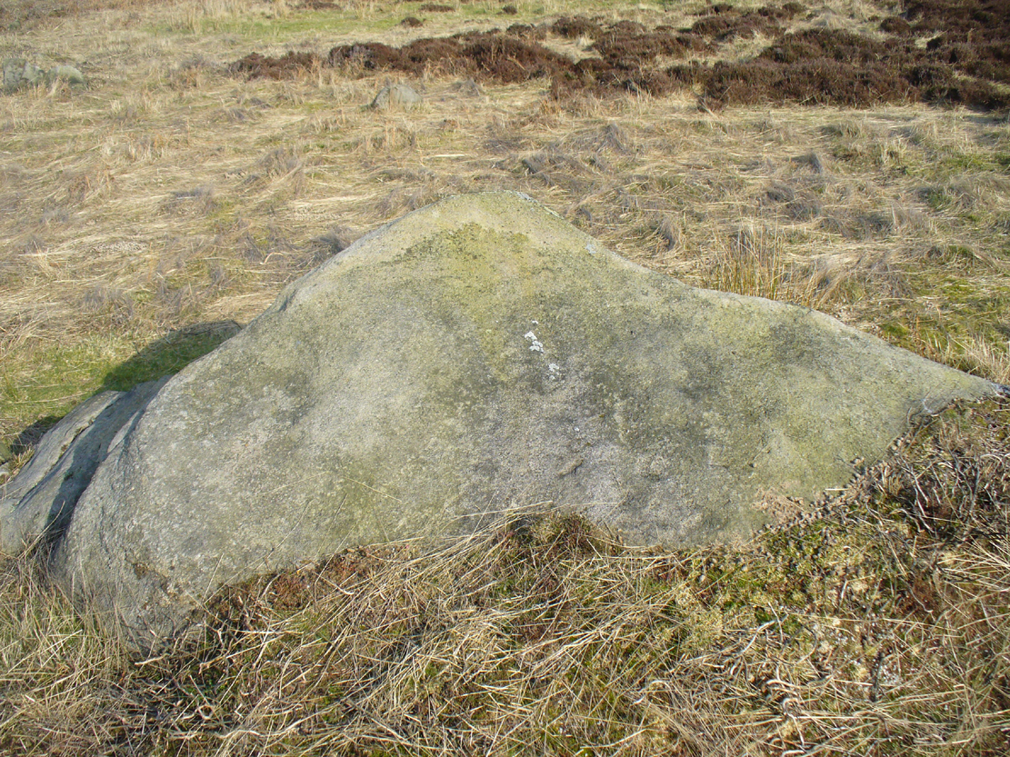
Follow the directions to reach the impressive Woofa Bank prehistoric enclosure. You need to find the walling that constitutes the enclosure itself and walk along to its eastern side where you’ll reach an ‘opening’, as if it may once have been an entrance at that side of the enclosure. A reasonably large sloping rock is on one side of this ‘entrance’. You can’t really miss it!
Archaeology & History
Unlike many of the other petroglyphs found within the Woofa Bank enclosure, the design on this one is faint — very faint indeed (much like the recently uncovered triple-ring petroglyph by the Thimble Stones). Comprising simply of a small cluster of cup-marks, you’ll struggle to see this one — unlike its compatriot on the western wall of the enclosure.
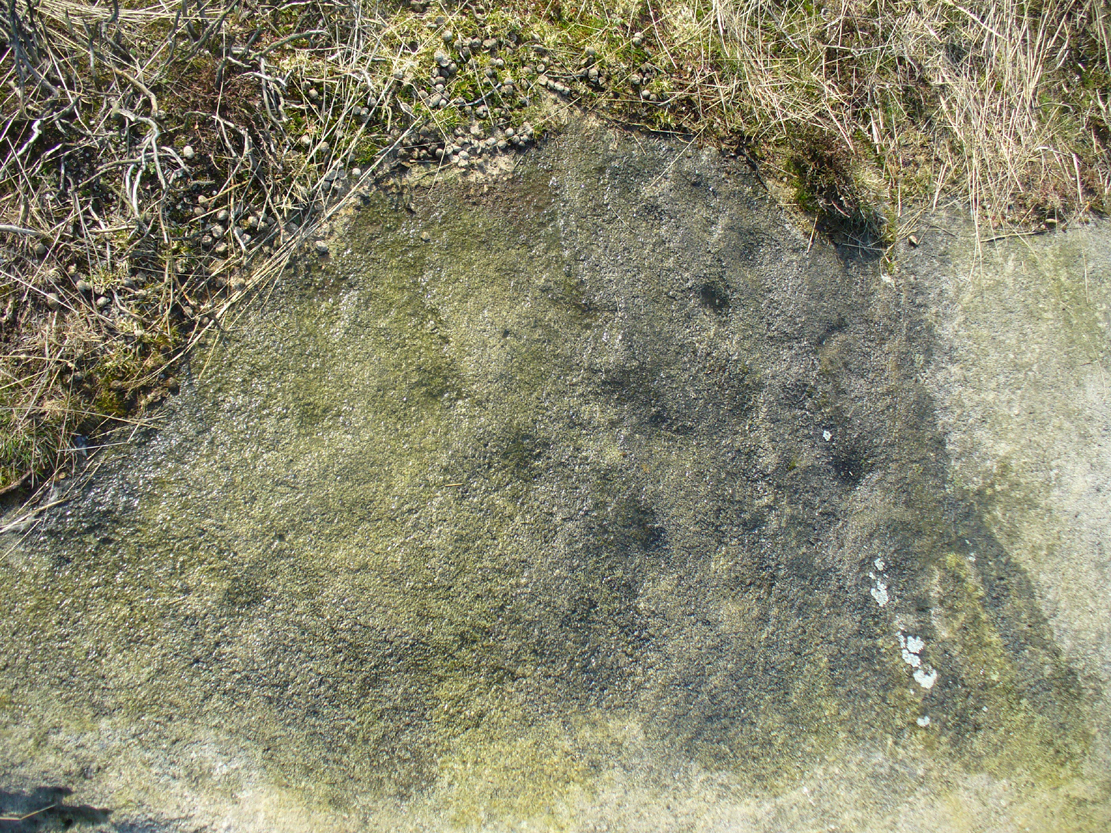
Looking down on the rockSome very faint cupmarks
It consists of a single cup-mark on the northern edge of the stone, whilst on the sloping southern part of the rock are a number of very faint cups, eroded by them there millenia of Nature’s wind and weathering. One or two of the cups are just visible in good lighting, but what are almost certainly a few more can be seen when the rock is wet and in low daylight hours. It’s a design that’s probably only of interest to the hardcore petroglyph fanatics, but without doubt this is yet another carving within this obviously important prehistoric enclosure.
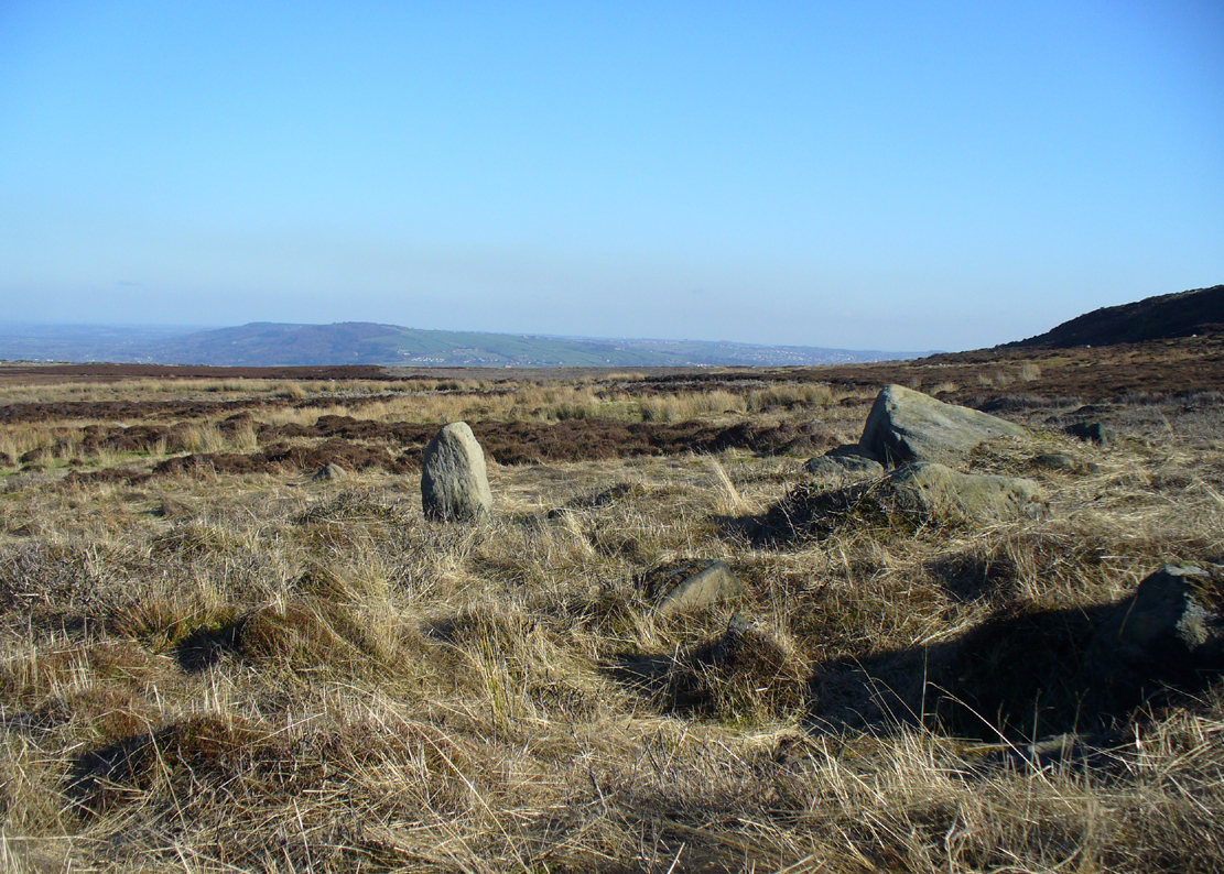
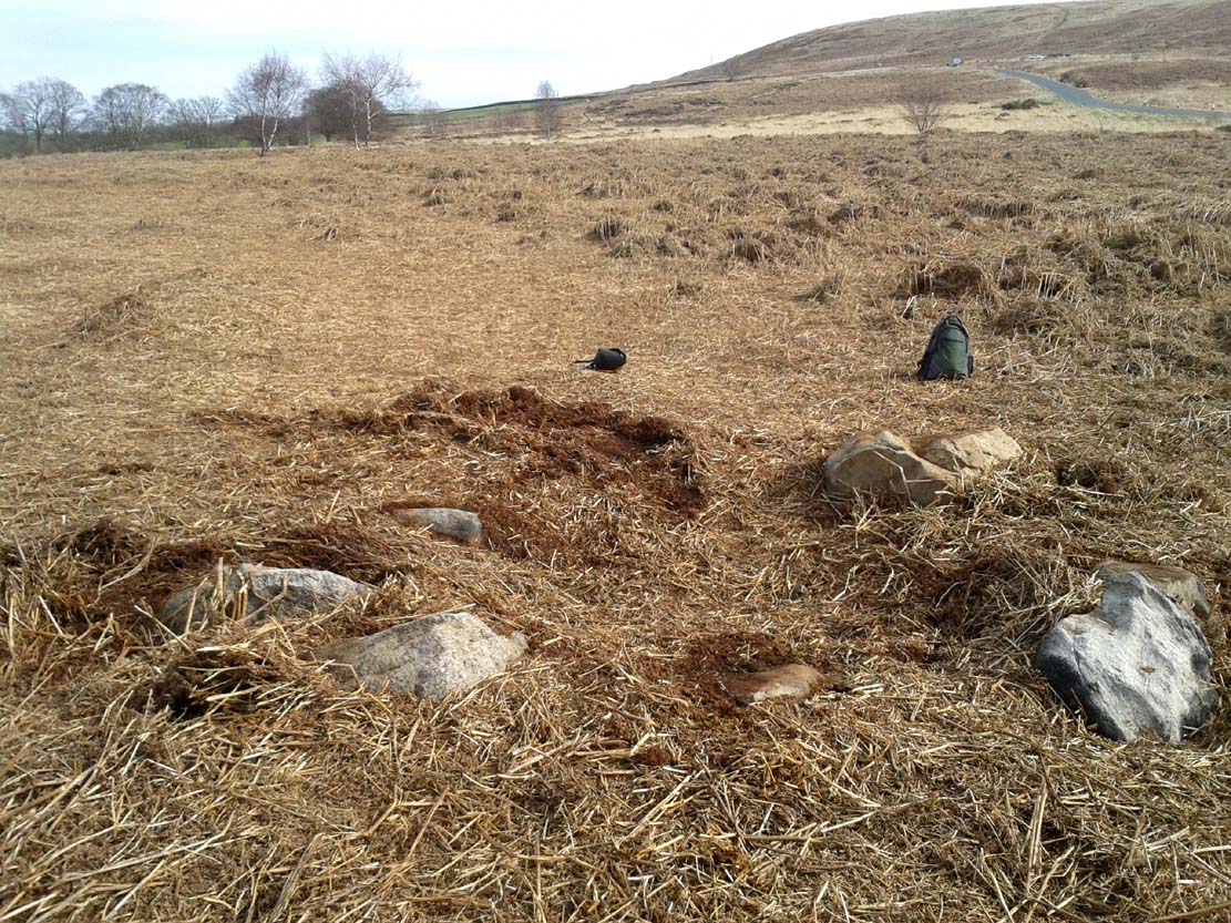
From the double-ring that is the Brackenhall Circle at Shipley Glen, go up the road towards the hills and seek out the cup-marked Glovershaw Quarry Stone. Shortly before this, notice the small trees close the quarry edge. From here, walk straight east, as if you’re going toward Baildon Hill. Barely 10 yards into the bracken you’ll notice this small ring of stones (best looked for in winter before the bracken grows back – otherwise you’ve no chance!).
Archaeology & History
This site was explored when James Elkington, Paul Hornby and I came across it on Wednesday, 11 March 2015, after returning from a short excursion to look at some of the petroglyphs on Baildon Hill.
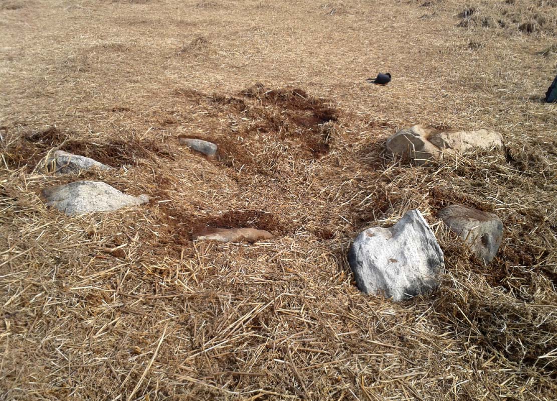
Ostensibly it is a small ring of stones comprising of at least 7 large rocks that are set deeply into the peat and bracken-mass, with a small eighth movable stone on the northern side. It seemed likely that another, larger rock was beneath this small portable rock, but we didn’t dig into the vegetative mound to explore this. The most curious thing about the ring of stones was that it measured barely 4 yards in diameter. My initial thought was that this was a previously unrecorded cairn, but there seemed to be no internal mass of rocks in the centre that characterize such monuments and which you’d expect in a ring of this size – meaning that it may be, perhaps, the smallest stone circle in Britain. It’s a pretty good contender at least! (the stone circle known as “Circle 275” at Penmaenmawr in Wales is of similar size to this one, but with less stones in that ring)
Close-up of the stones
It would be good if the regional archaeologists could give this site their attention and clean it up to see exactly what lays beneath the boscage. Close by are several cup-marked stones and a couple of other larger cairn circles.
The name of the site came after I almost stood on a hibernating toad, found beneath the bracken-mass right at the edge of one of the stones. I carefully picked him up and reburied him in another spot close by, leaving him (perhaps) to ponder his venture into the bright daylight of consciousness! Mr Hornby promptly declared – “these are the Toad Stones!” – and it stuck.
Near the centre of this photo, the large ‘ring’ can be seen
From Midgley go west along Height Road and take the track up on your right, at the tree-lined bend, up Foster Clough and onto the moor as if you’re gonna go to Churn Milk Joan. As you reach the footpath at the quarries up the hill, go to the top of them and take the small footpath where the land levels-out and head east towards the walling. Just a hundred yards or so before the walling, keep your eyes peeled, cos you’re damn close!
Archaeology & History
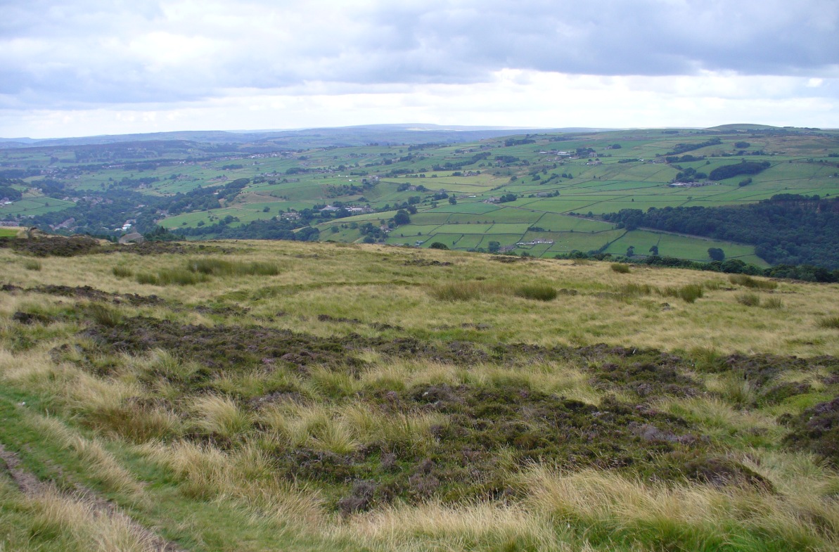
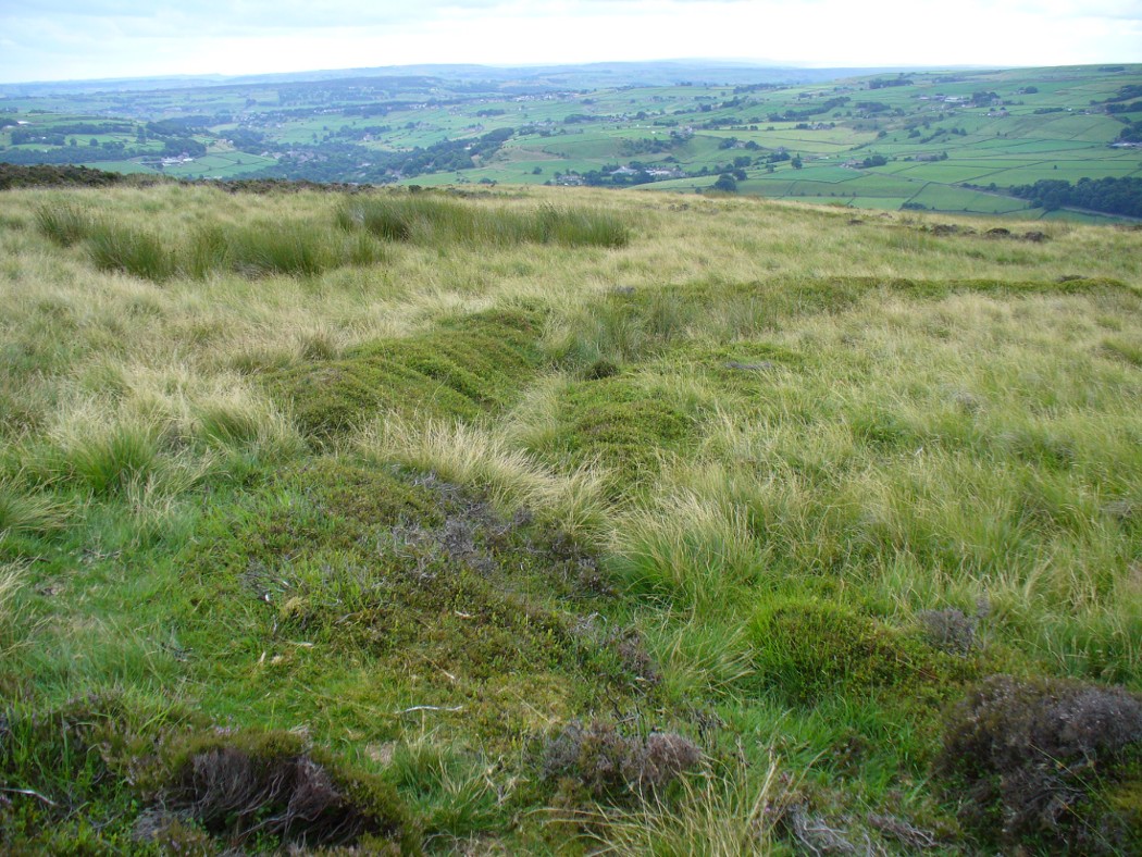
Best seen when looking down from the slopes above, this is a fascinating site that is lucky to still be here! For just a few yards to the west are extensive quarry works that could easily have destroyed the place had they continued. But thankfully we have here a near-perfect circular enclosure: measuring roughly 27 yards in diameter east-west, and about 25 yards north-south, the circumference around the outer-edge is approximately 82 yards (75m). It has all the appearance of an overgrown henge monument, with an outer bank and inner ditch, then a central flat arena—and it may indeed be such a monument—but until we have a decent excavation of the site, we’ll stick to calling it a simple enclosure—which it is!
Eastern arc of bank & ditch
The outer bank is very much overgrown, but as it runs round and defines this site, it measures 1-2 feet high most of the way, except on the westernmost spot, where it seems there may be an ‘entrance’. The inner ditch is only a couple of feet deep, again all the way round the monument. The internal level of the site is pretty flat, like most henges; but there seems to be a small central ‘cairn’ of some sort in the middle. Again, this is very overgrown by our traditional moorland vegetation.
Aerial image, 2009Aerial image, 2006
So what is it exactly? An enclosure, a settlement, or even (as local research student John Billingsley once suggested) a henge? Tis difficult to say for sure without further and more detailed archaeological excavation. My estimate is that the site is either Bronze- or Iron-Age in nature, and is definitely an ‘enclosure’ of some sort. We have located other prehistoric sites on the slopes just above here to the north, like the Crow Hill cairn circle and accompanying tumulus, remains of a neolithic settlement and a number of other small single cairns that are only visible when the heather has been burnt back. If you intend to explore any of the ancient sites sites on this moor, check this one out!
References:
Bennett, Paul, The Old Stones of Elmet, Capall Bann: Milverton 2001.
First highlighted on the 1850 Ordnance Survey map of western Addingham in the same year William Howson described it, this large oval embankment sits on the eastern side of Counter Hill, amidst its gigantic earthworks, with attending tumuli, cup-and-rings, buried standing stones and other enclosures, like one huge prehistoric family of ancient sites! The earthworks here are in slightly better condition than the nearby ones at Marchup, as we can still make out the ditch marking the site.
There have been many literary visitors to the Round Dikes and its cluster of sites. One of the early ones was by the renowned historians and antiquarians, Forrest & Grainge (1868) who, in the second part of their ‘rambles’ exploring the prehistoric sites on and around Rombald’s Moor in the 1860s, told us:
“The Camp—known locally as Round Dykes—is of an irregular oval shape, the longest axis measuring over all 300 feet, and the shorter 250 feet. The trench outside the vallum is about 15 feet wide, and 4 or 5 feet in depth. The area is level, showing no indications of buildings or works of any kind. A feeble spring of water rises at one corner. The trench is regular and even, and does not appear to have ever been used as a series of pit dwellings. This work commands a large and splendid view of Wharfedale…”
Although suggested by Thomas Whitaker (1878) in his magnum opus on the history of Craven, to have been constructed by the Romans—who laid a road nearby on top of another earlier trackway—the site is obviously prehistoric. But when the late great Harry Speight (1900) ventured over for a gander at the end of the 1890s, he too thought it might be Roman. Finding the place to be “thickly overgrown with ling,” it was still in very good condition he said, telling “how its outline is almost as perfect as when made seventeen or eighteen centuries ago.” He continued:
“The form bespeaks a rather late date, having the characteristic angles, which makes the ordinary streight-sided rectangle into an octogan, giving it the appearance superficially of a round or oval. Its dimensions are based on the most approved form of castramentation, the length being one-third greater than the breadth, namely sixty yards wide and eighty yards long. A watch-mound has been thrown up within the southwest angle, and the whole camp defended with a double rampart having an intervening ditch. There is an old and excellent spring of water on the east sie of the camp; the site having been well chosen, commanding as it does, a splendid view of the valley and Street as it runs towards Olicana.”
By the time Eric Cowling (1946) came and looked at these earthworks, the opinion had truly swayed to seeing Round Dikes as a prehistoric site and not Roman. Cowling placed it firmly in the Iron Age! His profile of the site told:
“On the Western slope of Counter Hill and with a wide view of Wharfedale to the east is a second enclosure with five sides. Three of these form the three sides of a square and the remaining two bend outwards to enclose a spring on the lower eastern side. This enclosure is one hundred feet across from east to west and in the opposite direction the greatest measurement is seventy-three feet. The ditch is fifteen feet wide and varies in depth from three to five feet and there appears to have been an entrance in the eastern angle. There is an unfinished look about the earthwork; the inner and outer banks vary in height and are not continuous. The position is badly sited for defence, being overlooked from the higher ground to the west. The site would be very suitable for excavation, for it has been untouched by cultivation and is undisturbed.”
E.T. Cowling’s plan
And as far as I’m aware, no such excavation has yet been done here; and as we all know the local archaeologist is pretty poor when it comes doing such things round here, so god only knows when the real explorers and scientists will ever get their teeth into the place! However, the writers and archaeology consultants John and Phillip Dixon told that “a limited survey of parts of Round Dykes defined nine hut circles or parts of circles and possible hearth sites” in the 1980s. And although they ascribe the large earthwork as being Iron Age, the tumulus which sits near the southern edge of the enclosure is ascribed as Bronze Age.
It’s likely that the internal tumulus (a separate profile of it is forthcoming) was of communal and religious importance at Round Dykes. There was probably ritual function here within the enclosure, though only at certain times, when and where the ancestral spirits in the tomb awoke or were required to help the living. The spring of water on the eastern side of the enclosure, above the tumulus, was obviously not just the main drinking supply for the people who stayed here, but would also have had ritual importance (water, forget not, is tantamount to blood in ancestral cosmologies, and not a ‘commodity’ as the half-witted retards in modern culture have profaned it in their shallow beliefs). In the Lands of the Dead, water is vital for gods, spirits and the sustenance of the underworlds. (Eliade 1979) You might not think that; judæochristians might not think that — but the worlds of experience are much wider and deeper than the failing beliefs of atheists and monotheists…
…to be continued…
References:
Bennett, Paul, The Old Stones of Elmet, Capall Bann: Milverton 2001.
Bennett, Paul, The Prehistoric Sites of Counter Hill, Addingham, forthcoming 2013.
Cowling, Eric T., Rombald’s Way, William Walker: Otley 1946.
Forrest, C. & Grainge, William, A Ramble on Rumbald’s Moor, among the Dwellings, Cairns and Circles of the Ancient Britons in the Spring of 1868: Part 2 – Counterhill and Castleberg, W.T. Lamb: Wakefield 1868.
Dixon, John & Phillip, Journeys through Brigantia – volume 1: Walks in Craven, Airedale and Wharfedale, Aussteiger Publications: Barnoldswick 1990.
Eliade, Mircea, A History of Religious Ideas – volume 1, Collins: London 1979.
Howson, William, An Illustrated Guide to the Curiosities of Craven, Whittaker: Settle 1850.
Speight, Harry, Upper Wharfedale, Elliott Stock: London 1900.
Whitaker, Thomas Dunham, The History and Antiquities of the Deanery of Craven in the County of York, (3rd edition) Joseph Dodgson: Leeds 1878.
Stone Circle (destroyed): OS Grid Reference – SU 0986 6713
Archaeology & History
Smith’s plan of the site
This all-but-destroyed megalithic ring is all-but-unknown in most of the archaeological gazetteers — including even Burl’s (2000) magnum opus! But we know it was there. And according to the Avebury authority Pete Glastonbury , there “are a couple or three small stones buried on the hill but nothing else to see.” Which is a pity, as the site sounds like it was something to behold in bygone times. Although it seems to have been described initially by the legendary druidical antiquarian, William Stukeley, a more lengthy description followed in the 19th century by the reverend A.C. Smith (1885), when he and a friend took it upon themselves to cut back some of the turf that was covering a number of stones — and they weren’t to be disappointed!
The site itself appears to have stood right on the southern boundary line of Avebury parish, meaning that the site could have been named and cited on any early boundary perambulation records that might exist of the parish. (do any of you Wiltshire folk have access to any such old records?) But if there are no such early accounts, the earliest record we’ll have to stick with is good old Mr Stukeley (1743), who only gave it a passing mention, saying:
“Upon the heath south of Silbury was a very large oblong work like a long barrow, made only of stones pitch’d in the ground; no tumulus. Mr Smith before-mentioned told me his cousin took the stones away (then) fourteen years ago, to make mere (boundary, PB) stones withal. I take it to have been an Archdruid’s, tho’ humble, yet magnificent; being 350 feet or 200 cubits long.”
Nearly 150 years later Reverend Smith gave us a more detailed account, and ground-plan, describing the place as,
“a stone circle, of considerable dimensions, though imperfect and formed of very small sarsens, but which I believe to have been in some way connected with Abury. Though it appears to have been mentioned by Stukeley one hundred and fifty years ago, it had been long since buried, and completely forgotten till I was fortunate enough to discover it by digging in the year 1877. I was led to the discovery by the suspicious look of certain stones which, though scattered in no regular form, appeared as if they might have once stood erect, in some sort of order, on the segment of a large circle. I had often stopped to examine them as I wandered over that part of the downs; till at last previous suspicions ripened into conviction, as closer observation revealed sundry other stones just showing above the ground, and there also seemed to be faint indications of a trench, all pointing, with more or less accuracy, to the supposed circle. Not to dwell upon the details of the investigation, which, however, were of singular interest to me, the result was that (with the permission of both owner and occupier of the land, and assisted by Mr William Long), I probed the ground in every direction, and uncovered the turf wherever a stone was found: and on our first day’s work we unearthed no less than twenty-two sarsen stones, all forming part of the circle, and lying from two to twelve inches below the surface. These stones were all of small size, some of them very small, but that they were placed by the hand of man in the positions they now occupy, in many cases nearly touching one another, and that they formed part of a large circle or oblong, admits, I think, of no doubt. I say part of a circle, because, though the northern, southern and eastern segments are tolerably well defined, I could find scarcely a single stone on what should be the western segment to complete the circle. That the area thus enclosed is not insignificant will appear from the diameter (in length, or from north to south, 261 feet; and in breadth, or from east to west, 216 feet). Again, its position (due south of Silbury, and within full view of it, as well as the Sanctuary on Overton Hill, and with Abury immediately behind Silbury, due north of it, from which also Silbury is equidistant) seems to intimate that it may have had some connection with the great temple.”
A ley running through the circle (image courtesy Paul Devereux)
Smith then proceeded to query the nature of the monument, commenting on how Sir John Lubbock and members of the British Archaeological Association were intrigued by the remains, but a little perplexed and unable “to form any opinion” as to the exact nature of the site. But this didn’t stop mythographer and historian Michael Dames (1977) who, in his classic Avebury Cycle, suggested that the site “marked the navel of the landscape goddess” in the region.
The site didn’t go unnoticed in Devereux and Thomson’s (1979) classic Ley Hunter’s Companion, where it plays an important point along a ley that runs north-south for 13 miles between Bincknoll Castle at the north, to Marden Henge at the south. Such an alignment had been noted much earlier by other archaeologists and historians.
The site does look strange for a stone circle in Smith’s ground-plan and has more the hallmarks of a type of enclosure or settlement of some sort. It certainly wouldn’t be out of place, design-wise, as a prehistoric settlement in our more northern climes. However, without further data it seems we may never know the true nature of this old stone site…
References:
Dames, Michael, The Avebury Cycle, Thames & Hudson: London 1977.
Devereux, Paul & Thomson, Ian, The Ley Hunter’s Companion, Thames & Hudson: London 1979.
Troublesome to get to if you don’t know the area. You can get here rom Halifax, up through Highroad Well towards Wainstalls, keeping to the road that leads to the Oxenhope windmills. A short distance before the windmills, as the road levels out, keep your eye out on the right where the valley drops down (east) to the Halifax golf-course. If you’re coming from Oxenhope, walk up past the windmills at Nab End until the road starts going back downhill. As you look down and walk past the valley with the golf course in it, a footpath is on your left running diagonally over a field. Cross the stile and walk alongside the wall for about 200 yards until you reach a gate on your left. Go through this and walk along until you see the ditched earthworks that make up this little-known monument…
Archaeology & History
Not to be confused with the large circular enclosure that once crowned the nearby Hunter Hill, the nature and age of this large D-shaped earthwork has long been a source of speculation, with the majority of it centring around a Roman origin — and for good reason, it has to be said!
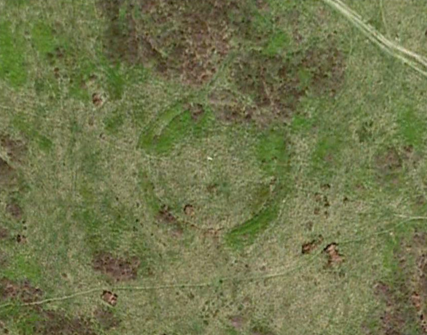
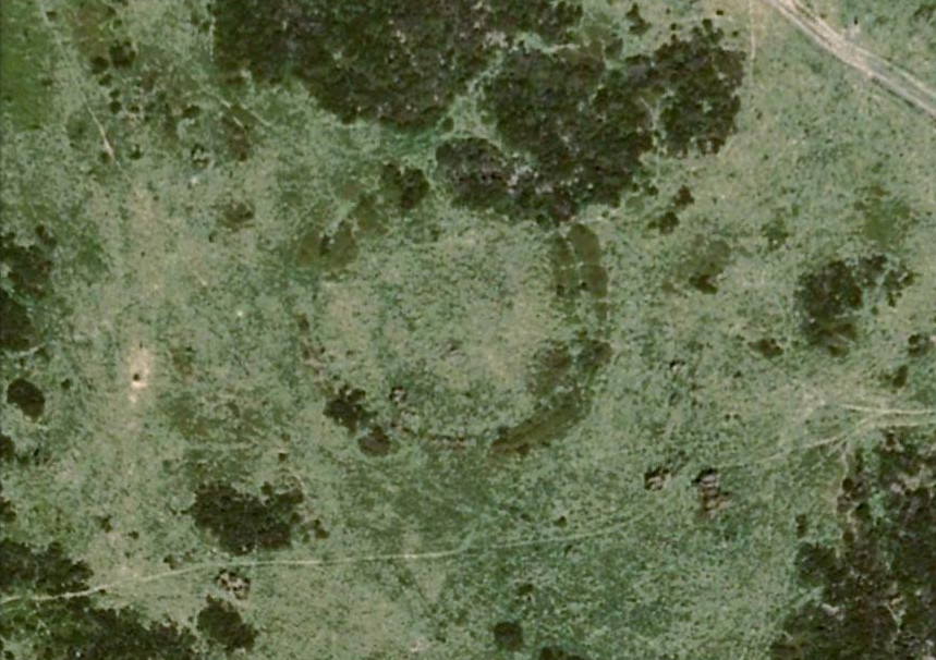
NW section of earthworksSouthern section of ditch
More than 280 yards (260m) in circumference, its north-south axis measures 82 yards (75m) at the greatest and 88 yards (81m) east-west. Its main feature is a decent ditch that averages 8-10 feet across round most of the D-shaped feature, and between 2-3 feet deep. It would obviously have been deeper than this when the ditches were first dug, but it’s now very overgrown across the entire site with Juncus grasses and tribbles (tussocks). A small internal ditch runs into the enclosure from the northern side. Its function is unknown. A small mound near the centre of the site has been posited by Calderdale archaeologists to be modern remains.
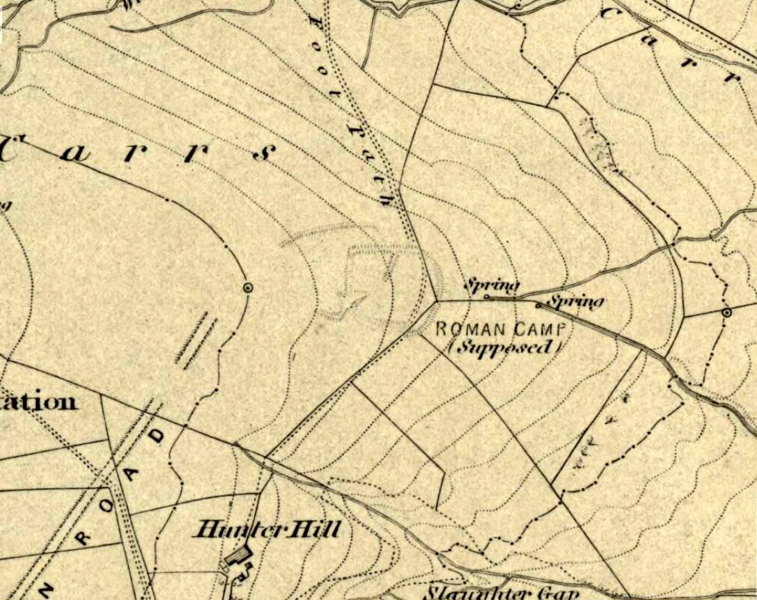
Carrs enclosure on 1852 map
Although the main feature is the D-shaped earthwork, other features are apparent. For example, what looks like another man-made dyke cutting into the site on the southwestern side is in fact a natural stream channel. This natural feature may have been an integral part of the enclosure when it was first built. Above the northwestern edge of the ditch (as can be seen on the aerial photo) are other earthworks that run around the western edge of the main feature. This is probably what F.A. Leyland (1867) meant when he described there to be “the remains of several lines of intrenchments” here. Also coming into the southwestern side are what are thought to be the remains of a Roman Road. Early OS-maps (above) show the road running within yards of this enclosure — and it was this which, logically, led many earlier researchers to posit the notion that this site was in fact Roman. However, a dig here in 1951 recovered prehistoric pottery, which knocked the date back to the Iron Age.
Northern line of ditch
On the south and east sides, parts of the ditch and embankment have been removed by quarrying and farm-workings, with the walling on the eastern side completely ruining that part of the monument. A great number of flints have been found on the hills above here. I’m unable to give a more detailed exposition on the archaeological finds at this site as I don’t have a copy of Mr Varley’s (1997) essay that he wrote for the Transactions of the Hunter Archaeological Society, which apparently gives more info. When I manage to get a copy of the journal/essay, I’ll add the relevant data to this profile.
A note must also be made of another, previously unrecognized enclosure on the same hilltop a couple of hundred yards to the west from here. Very little trace of it is still visible at ground level, but the outline of the curvaceous quadrilateral ditch form can be seen from the air. It would appear from its form to be consistent with an Iron Age enclosure, though without further research this has to be proclaimed as hypothetical. No excavations are planned here in the near future.
Folklore
In F.A. Leyland’s (1867) superb commentary to Mr Watson’s History of Halifax, he told us:
“There is a well-preserved tradition amongst the inhabitants that a battle in which numbers fell was fought at a place called the Slaughters or Slaughter Gap, in the hollow between the Carrs and Hunter-hill. Fragments of gun-barrels and locks, with human bones, have been found about the place…”
But Leyland deemed the armoury finds here — that appeared to substantiate the folklore — were from a much later period in history than the enclosure. But I must draw attention to the remarkable Mixenden Finds, as they’ve become known: a collection of finely polished prehistoric axes and other stone remains a few hundred yards below The Carrs and which may relate to such folklore.
References:
Leyland, F.A., The History and Antiquities of the Parish of Halifax, by the Reverend John Watson, M.A., R.Leyland: Halifax n.d. (c.1867)
Varley, Raymond, “The Excavation of Castle Stead at Manywells Height, near Cullingworth, West Yorkshire,” in Transactions of the Hunter Archaeological Society, volume 19, 1997.
Varley, Raymond A., “Lost Neolithic and Bronze Age Finds from Mixenden, near Halifax, West Yorkshire,” in Yorkshire Archaeological Journal 70, 1998.
Easy enough to locate. In Grassington go up the main street a coupla hundred yards, turning left up past the small church, taking the footpath on your right heading up to the fields that stretch to the north. Don’t mistake the remains of the medieval village that you’ll pass for the Iron Age and Romano-British site that we’re heading for, another coupla hundred yards up. You’ll notice a lot of old low walling structures on the slopes heading up above you. That’s the stuff!
Archaeology & History
Despite the industrial devastation of the landscape on the hills around here, this entire area still teems with prehistoric archaeological remains, making you wonder just how much more once existed in this region. In bygone days Prof Anne Ross thought this region to be the capital of northern England in Iron Age days. She could be right: in just about every nook and cranny of small valleys and rivulets we find evidence of ancient people everywhere for miles around, settlement upon settlement in every direction you take. The remains found here at High Close Pasture typifying the examples any ardent antiquarian will come across in this region of upper Wharfedale.
Druid’s Circle (Bogg 1904)Earliest known photo in 1899
The settlement remains and ancient cultivations at High Close have been described by various writers over the last hundred years, with Edmund Bogg (1902) calling the most notable of the remains here the ‘Druid’s Altar’ (not to be confused with the other Druid’s Altar at nearby Bordley); a title that was similarly described as “The Druid’s Circle” when Eliot Curwen surveyed the area. It is also locally known as ‘The Circus’, after it being a place where celebrated events once took place. This Druid’s Circle section is,
“an oval area 150 feet long by 75 feet wide. It consists of a bank surmounted by a single or double-row of flat-topped stones about one-and-half feet high by 2 feet wide… This may have been a communal meeting place of the Iron Age folk, who cultivated these fields, and who lived in isolated huts.” (Elgee & Elgee 1933)
The notion of the circle being a communal meeting place was echoed by Mr Curwen (1928) in his slightly more detailed description of this place. He told that the interior of the Druid’s Circle had been levelled:
“It lies eight feet below the surrounding banks to the northeast and east, to which it rises with a gradient of 8 in 21. The bank to the north is less high, while to the south and west the arena, while seperated from it by the bank, is above the level of the sloping hillside. The encircling bank is surmounted by a single (and) double row of stones for three-fourths of its extent. These are apparent to the east and south, but are less so to the west, as along this side a stone wall has been built actually along the bank of the Circus; the stones belonging to this bank are, however, quite clear below the footings of the wall. From northeast round by south to southwest the row of stones is double. Those in the inner row, forty-six in number, stand some eighteen inches high; they are about two feet wide and are flat-topped, the line is almost continuous, and in parts the stones are placed edge to edge. A second row of smaller stones backs the larger ones. Entrance is obtained to the central level area by a gap to the southwest. No fosse surrounds this earthwork. To the southeast, a lynchet four feet high runs off it, while to the north a low stoney bank runs off in a NW direction, and one of the larger stony banks approaches to within a few feet of the northwest.”
In the fields above, particularly on the east and north of this notable ruined stone ring, the extensive “cultivation pastures” as they’ve been called, are evident all over the place. Hut circles and copious other antiquities can all be found within a square mile of this spot. If you like your Iron Age archaeology, this area will knock yer socks off!
…to be continued…
References:
Bogg, Edmund, Higher Wharfeland, James Miles: Leeds 1904.
Charlesworth, Miss D., ‘Iron Age Settlements and Field Systems,’ in Archaeological Journal, volume 125, 1968.
Curwen, Eliot, ‘Ancient Cultivations at Grassington,’ in Antiquity, June 1928.
Elgee, Frank & Harriett, The Archaeology of Yorkshire, Methuen: London 1933.
Raistrick, Arthur & Chapman, S.E., ‘The Lynchet Groups of Upper Wharfedale, Yorkshire,’ in Antiquity, June 1929.
Speight, Harry, Upper Wharfedale, Elliott Stock: London 1900.
C.F. Forshaw (1908) told us that “this Castlestead…lies on the high ground between Cullingworth and Denholme, about 300 yards east of the point where te Cullingworth Road meets the Halifax-Keighley Road in Manywells Height, and over looks Buck Park Woods and the beck flowing down a deep ravine to enter the head of Hewenden Reservoir. A little to the north lies Moat Hill Farm…and the ancient burial place therewith associated.” Very little remains of the site can be seen.
Archaeology & History
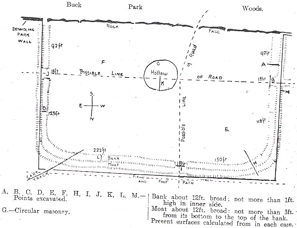
C.F. Forshaw’s 1908 plan of this Castle Stead site
Just over a mile southeast of the site of (virtually) the same name — the Castlestead Ring — this here Castle Stead site had me thinking that both sites were one and the same (poor research on my behalf I’m afraid). At the moment, the archaeological period of when this site was constructed remains unknown. Thought by Forshaw (1908) to be “almost certainly a hitherto unknown Roman entrenchment,” the very slight remains left here could be Iron Age or Romano-British. In his lengthy article on the remains that could be seen here more than 100 years ago, Mr Forshaw told us:
“Several fields hereabouts bear the name Castlestead and one of these contains the entrenchment, which almost coincides within its area… The reason for the selection of this site is clear, for on no side is it commanded by higher ground: whilst one face has a natural fortification of a rock scar impassable at most points and easily accessible at none. Here very little art would make the position impregnable in primitive warfare, and it is noticeable that the most suitable part of the verge has been selected, and almost the whole of the scar has been included. It is, however, only right to state that stone has been quarried here within living memory and this may have altered the ground considerably, and may account for several features mentioned hereafter.
“The accompanying plan (above) will make the outline of the fortification clear, and from it one can readily recognise the usual Roman form. The moat and bank, the quadrangular shape with rounded corners and the entrances on three sides (and possibly on the fourth also) are characteristic. The unusual point is the selection of a natural fortification for one (the south) side.
“The question at once arises: was this a permanent stone fort? Clearly not, for the bank has been cut across at four places (A, D, H & L) and not only was no stone found — beyond such odds and ends as may be seen in any field — but the deeper, undisturbed layers of silt showed no signs of a trench in which foundations might have stood. It is noticeable that there are more stones on the crown of the bank than elsewhere. This I take to be the remains of what was thrown up in the bank. The field has been cultivated many years, so that the bank has been much reduced in height and the moat filled up.
“The original height of the bank is difficult to guess, but the moat was about three feet deeper than at present at the point H, and from the amount of soil removed we may imagine the bank about five feet higher than it is now, and solid at that; this makes a total outside slope of about 10 feet, a very formidable obstacle to surmount in the face of opposition, especially is strengthened by a stockade, such as was possibly present.The remains of the bank are capped with a layer of some six inches of bluish, silty clay. This was evidently placed there deliberately, and is in accordance with Roman work as seen elsewhere (e.g., at Castleshaw, near Oldham). There is also some slight evidence that, as at Castleshaw, the moat was once faced with irregular pieces of flat stone. The moat was some 18 feet across at the top, six feet at the bottom and five feet deep. The east and west sides were probably less strongly entrenched. Certainly the moat was much less, for rock lies only just below the sod, halfway along the western side. When the southern face is examined there are more signs of stonework, however, for where the rock is deficient the gap is filled with the remains of a dry wall which has some peculiar characteristics. In places the lower part of this wall is formed of roughly-shaped oblong blocks of large size (one has a face of 57 x 17 inches), arranged in definite tiers. This is not like an ordinary field fence, and differs even more from the ancient wall marked (probably erroneously) as Denholme Park Wall on the Ordnance map, which it continues: so it is conceivable that it may be Roman work. There is now little or no sign of a bank along the rocks bounding the southern side of the camp, but it is probable that something once existed to give cover to the defenders, and we may well imagine a low dry wall continuous with the fragments just described: and it is rather noticeable that there are more squared stones in the walls of this field than in others in the neighbourhood.
“There are no traces of buildings within the lines so far as the present investigations go, nor signs of prolonged occupation at the site. I have dug at the points indicated (on the map above) and came upon rock or disturbed silt in each case. The circular shallow hollow in the centre seems natural. It is to be remarked that the average depth of surface soil in this field is unusual, more than one foot in fact.”
Mr Forshaw then goes on to ask a series of questions, followed by his own particular answers and theory relating to the nature of these earthworks. Hopefully you won’t mind if I cite his ideas in full, despite him thinking that the remains here are of Roman origin (remains of which I don’t really wanna include on TNA). He continued:
“Was this camp on the course of a Roman road? One can only say that no definite road exists at the entrances now, but there seems some ground for thinking that a surface was prepared…at the western entrance for two reasons:
1. Just to the north the rock is covered with made soil only; but in the entrance itself irregular stones are packed in a level, solid manner, giving a strong impression of artificiality. At the southern verge of the entrance this layer ends abruptly in a line at right angles to the bank, and here it is based not on rock, but on natural silt.
2. A slight hollow runs straight westward from it for some twenty yards through the next field. This may represent a destroyed road.”
Mr Forshaw then makes a few attempts to justify this idea, including notices of footpaths and linear features near the site, aswell as citing earlier historical sources that describe Roman roads — but the ones cited are some considerable distance from this site. In summing up, he notes how no Roman finds were made here — nor indeed any finds from earlier periods — but he opted for the site being a temporary Roman outpost. The more recent opinions of this place are that it was of late Iron Age or Romano-British origin.
References:
Cudworth, William, Round about Bradford, Thomas Brear: Bradford 1876.
Forshaw, C.F., ‘Castlestead, near Cullingworth,’ in Yorkshire Notes and Queries – volume 4, H.C. Derwent: Bradford 1908.
Hindley, Reg, Oxenhope: The Making of a Pennine Community, Amadeus: Cleckheaton 2004.
James, John, The History and Topography of Bradford, Longmans: London 1876.
Keighley, J.J., ‘The Prehistoric Period,’ in Faull & Moorhouse’s, West Yorkshire: An Archaeological Survey to AD 1500 – volume 1, WYMCC: Wakefield 1981.
Varley, Raymond, “The Excavation of Castle Stead at Manywells Height, near Cullingworth, West Yorkshire,” in Transactions of the Hunter Archaeological Society, volume 19, 1997.
You can come from various angles to approach this site, but I reckon the best is from along the old trackway of Parson’s Lane, between Addingham and Marchup. From Silsden go up the long hill (A6034) towards Addingham until the hill levels out, then turn left on Cringles Lane (keep your eyes peeled!) for about 500 yards until you reach the Millenium Way or Parson’s Lane track, to your right. As you walk along this usually boggy old track, the rounded green hill ahead, to the left, if where you’re heading. Less than 100 yards past the little tumulus of High Marchup there’s a stile on your left that takes you into the field. You’ll notice the depression that runs across near the top, at an angle. That’s part of the earthworks!
Archaeology & History
The Counter Hill earthworks just over the far western edge of Rombald’s Moor – thought to be Iron Age – are truly gigantic. More than ¾-mile across along its longest NW-SE axis, and a half-mile from north-south at its widest point, this huge ellipse-shaped earthwork surrounds the rounded peaked hill that gives the site its name: Counter Hill. And although Harry Speight (1900) thought the hill got its name from the old Celtic conaltradh, or Irish conaltra, as in the ‘hill of debate or conversation’ — a possibility — the place-name master Mr Smith (1961) reckoned its name comes from little other than ‘cow turd hill’! We may never know for sure…
Earthworks south of Counter HillCowling’s 1946 plan
The Lancashire historian Thomas Dunham Whitaker (1878) appears to have been one of the first people to describe the Counter Hill remains, though due to the sheer size of the encampment he thought that it was Roman in nature. Within the huge enclosure we also find two large inner enclosures, known as the Round Dikes and the Marchup earthworks. Whitaker’s description of Counter Hill told:
“There are two encampments, on different sides of the hill, about half a mile from each other: one in the township of Addingham, the other in the parish of Kildwick; the first commanding a direct view of Wharfedale, the second an oblique one of Airedale; but though invisible to each other, both look down aslant upon Castleburg (Nesfield) and Ilkley. Within the camp on Addingham Moor are a tumulus and a perennial spring; but by a position very unusual in such encampments, it is commanded on the west by a higher ground, rising immediately from the foss. The inconvenience, however, is remedied by an expedient altogether new, so far as I have observed, in Roman castramentation, which is a line of circumvallation, enclosing both camps, and surround the whole hill: an area, probably, of 200 acres. A garrison calculated for the defence of such an outline must have been nothing less than an army. But it would be of great use in confining the horses and other cattle necessary for the soldiers’ use, which, in the unenclosed state of the country at the time, might otherwise have wandered many miles without interruption. The outlines of these remains is very irregular; it is well known, however, that in their summer encampments the Romans were far from confining themselves to a quadrangular figure, and when we consider their situation near the Street, and the anxious attention with which they have been placed, so as to be in view of Ilkley or Castleburg, there can be little danger of a mistake in ascribing them to that people.”
Counter Hill earthworks, looking west
And though Whitaker’s sincerity and carefully worded logic for the period is quite erudite (much moreso than the greater majority of historians in modern times), his proclamation of the Counter Hill earthworks as Roman is very probably wrong (soz Tom). The embankments are much more probably Iron Age in nature and are very probably the result of indigenous tribal-folk than that of the incoming Romans. Most modern archaeologists and historians tend to see the entrenchments as being from such a period and I have to concur.
Folklore
The old antiquarian Edmund Bogg (1904) wrote that the Counter Hill earthworks were built as a result “of the struggle between the Anglians and the Celt,” long ago. The great Yorkshire historian Harry Speight (1900) narrated similar lore just a few years earlier, but told that the tradition was “of how the Romans drove the natives from this commanding site of Counter Hill.”
References:
Bogg, Edmund, Higher Wharfeland: The Dale of Romance, James Miles: Leeds 1904.
Cowling, Eric T., Rombald’s Way, William Walker: Otley 1946.
Fletcher, J.S., A Pictureseque History of Yorkshire – Part IX, J.M. Dent: London 1901.
Smith, A.H., The Place-Names of the West Riding of Yorkshire – volume 6, Cambridge University Press 1961.
Speight, Harry, Upper Wharfedale, Elliott Stock: London 1900.
Whitaker, T.D., The History and Antiquities of the Deanery of Craven, 3rd edition, Joseph Dodgson: Leeds 1878.


")


")
")
")