If you’re coming by car, Braco’s an easy place to park. Once here, walk up the main road, past the terrace houses until, on your left, you reach the B8033 Feddal Road. About 500 yards on, where the houses end and you reach the small river bridge, you’ll notice a footpath immediately on your left with a small table where you can have a cuppa. Walk past this, into the trees and along the riverside for barely 100 yards, and walk up the hillside on your left. On your way up are a couple of large humps, a bit like a small roller-coaster. You’re here!
Archaeology & History
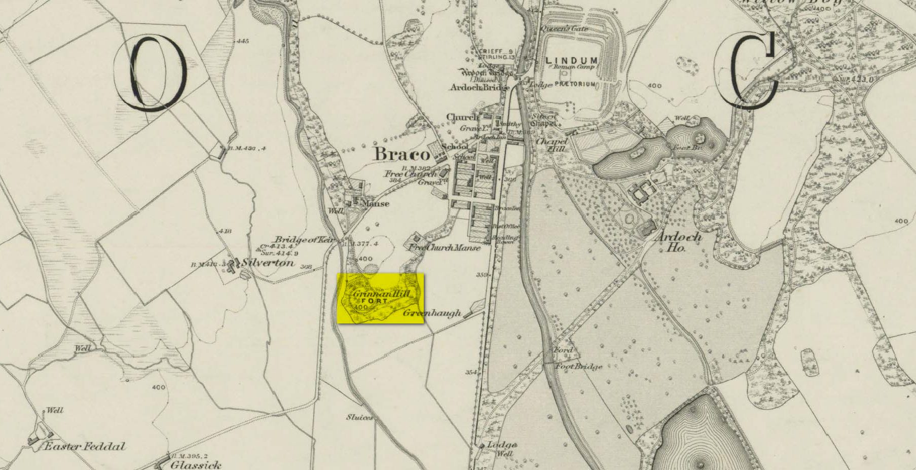
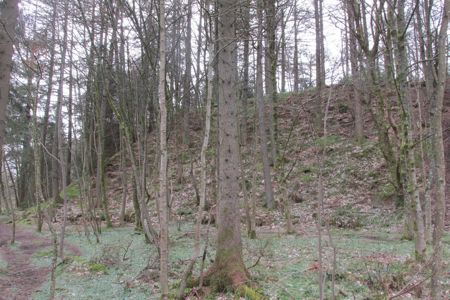
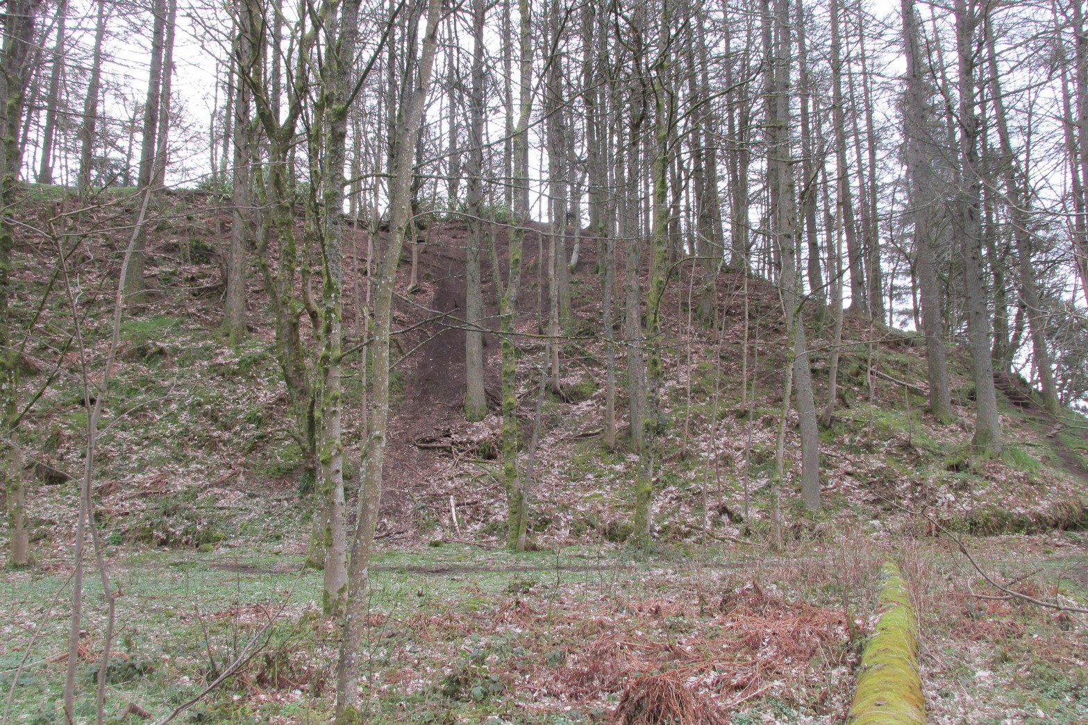
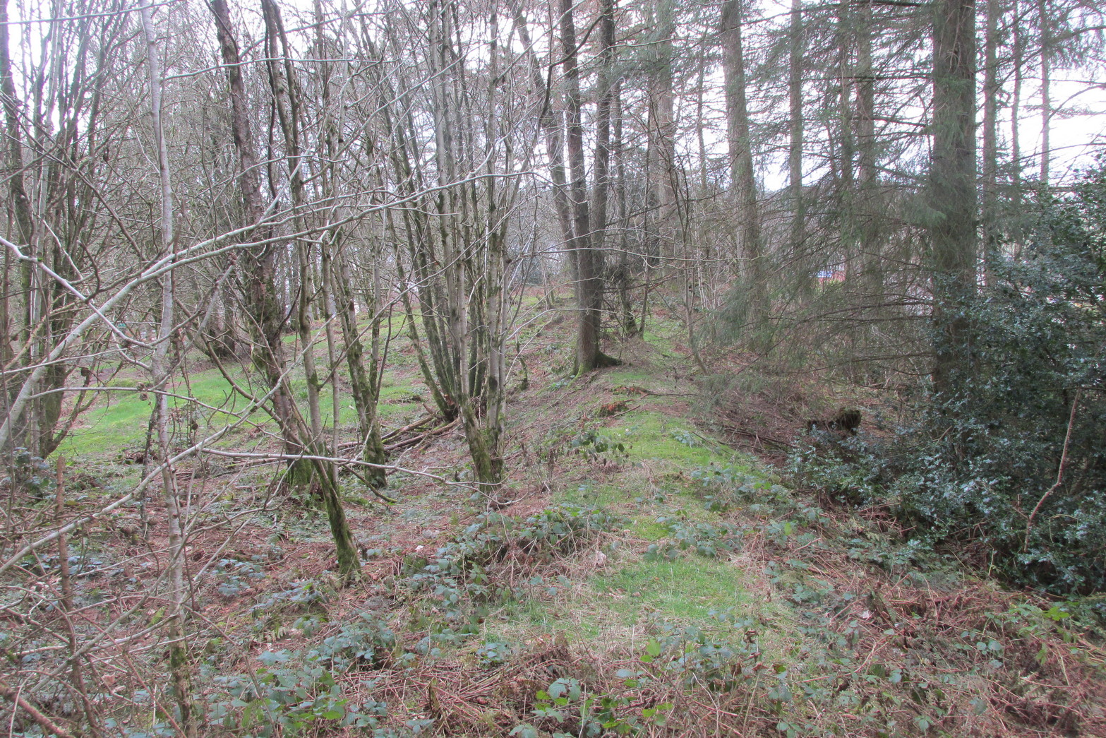
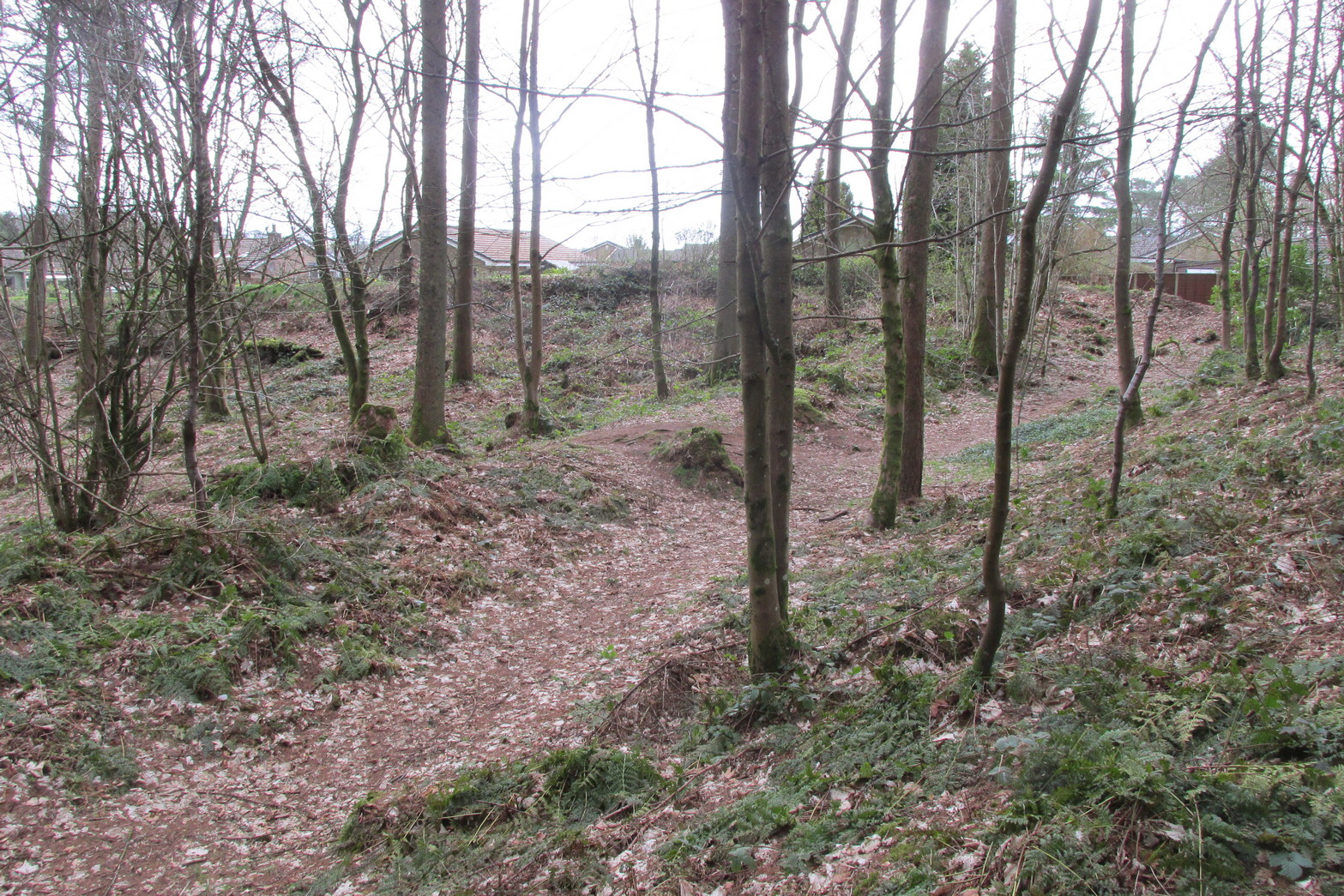
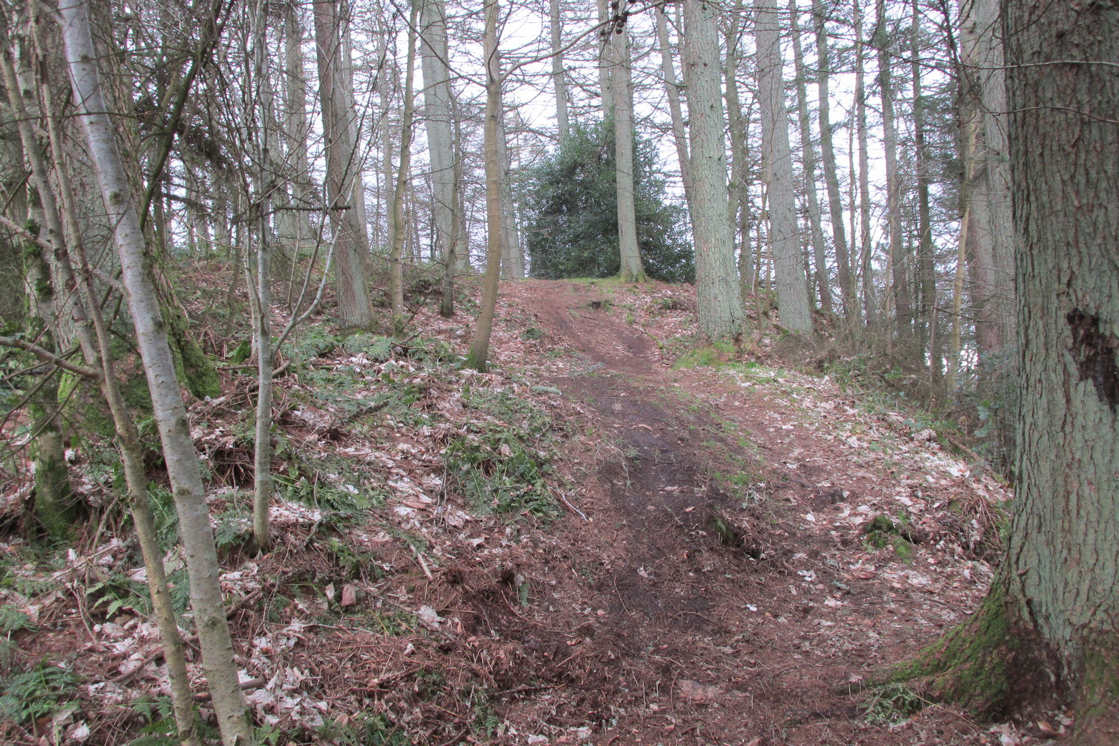
Antiquarians amongst you are gonna love this. It’s huge! Hiding away and all but forgotten in the little village of Braco, overgrown with trees and brambles, this steep wooded defensive structure has a series of large ramparts—three in all—that you’ll walk up and down before hitting a slightly undulating summit.
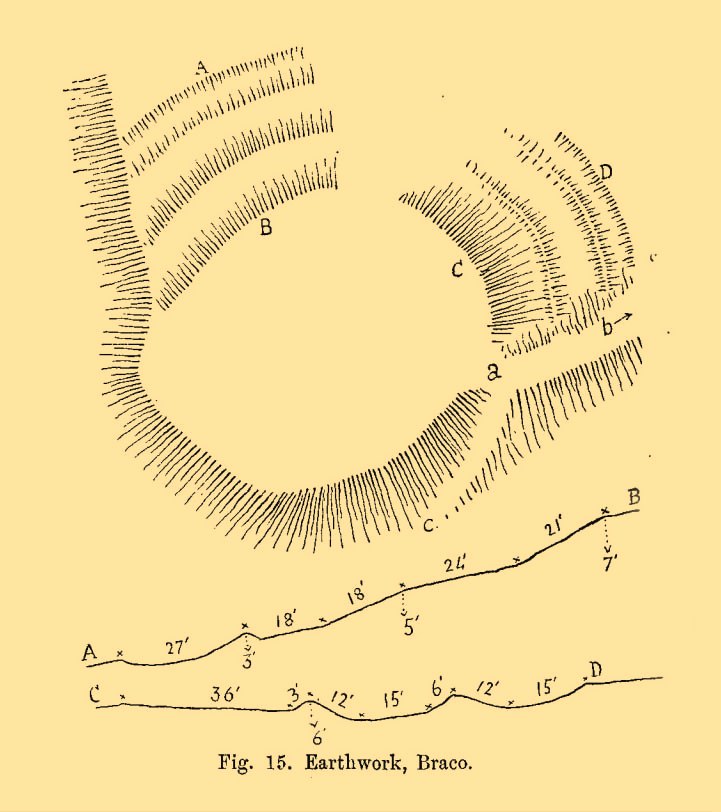
William Roy’s 1793 planChristison’s 1900 plan
The site was shown as an unnamed triple-ringed hill on William Roy’s 1747-52 survey of Scotland, with the lines representing the ramparts of this ‘fortress’. Some years later, Roy (1793) briefly mentioned the site when he was comparing indigenous fortifications with those of the Roman invaders, saying that “the small camp at Ardoch” probably “contained more than a Roman legion, with their auxiliaries.” His sketch and layout of the hillfort (right) is interesting in that it shows the more compete fortified ramparts on the north-eastern sides, which have today been covered by the modern houses. The ramparts in this part of the hillfort were still visible when the brilliant Miss Christian MacLagan (1875) came here; and in a subsequent visit by Mr Christison (1900) they could still be seen, as we can see in in his sketch (left). When we visited recently, it looked as if the lads who’d landscaped the large gardens most probably, unknowingly, used the soil of the ramparts to create them!
Apart from the missing northeastern ramparts, the site today is little different from when our antiquarians wrote of it more than a hundred years back. Read Miss MacLagan for example, who said:
“Near the parish church is an eminence called Grianan Hill, on which are still to be traced the remains of a British fort. The hill is a beautifully wooded knoll to the west of the village of Braco. It appears to be about 100 feet in height above the level of the surrounding land; on three of its sides the ground is perfectly flat, and we could suppose that in the amply days of the fort above, it had been environed on three sides by a lake, which would of course contribute to its strength. The fourth side of the hill, having but little natural strength, has been strongly fortified by three great walls. This is the side which connects the knoll with the neighbouring rising ground which is nearly as high as itself.
“The area enclosed by the innermost circular wall has a diameter of 130 feet. The space between this wall and the second is 37 feet, and the space between the second and third walls 47 feet. Almost every stone of this fort has been removed, but the lines and trenches which mark their former presence are still very distinct.”
Christison (1900) subsequently gave us much the same, with just some additional points here and there:
Looking up at SW sideLooking up at S side
“The site is less than ½-mile SW of Ardoch camp, 420 ft above the sea, on the edge of a steep descent, 40 to 50 ft high, to Keir Burn, but only slightly elevated above the field towards Braco village. It has apparently been an earthwork with a semi-oval triple line of defence…partly ramparted and trenched, partly terraced, the broad oval being rudely completed by the unfortified edge of the steep bank. The entrance, a, is along the narrow crest of a ridge, i, from the E, and it is likewise approached by a rude roadway, c, from the burnside below. Roy’s plan makes the work nearly complete, but the middle half of the lines no longer exists. He says that it may have been a work of the natives before the arrival of the Romans, but calls it a (Roman?) ‘post.’ There can be no doubt that it belongs to a common type of native fortresses. Its extreme length is about 320 ft, and the interior may have been about 200 by 170.”
Southern line of wallingFootpath along rampart
What he failed to point out—and contrary to Canmore’s comment that “the interior is featureless”—is the length of internal walling running nearly halfway through the top of the hillfort, cutting it in half so to speak, roughly southeast to northwest: the eastern area slightly larger than the west, which is a little higher. A ‘gate’ or passage between these two sides seems apparent halfway along this line of walling. This wall, like the long one running along its southern edge, is a couple of feet high and more than a yard across. In the western section a small pit has been dug, about eight feet across and a yard or so deep. Local lore tells that this was an old Roman fire-pit!
Around the very bottom mainly on the west-side of the hill, remains of old walling can be seen for a couple of hundred feet beneath the vegetation, but I’m unsure about the date of this structure. It may well be a 19th century construction, but without an excavation—and none has ever been done here—we will never know for sure.
Undulating ramparts
One final thought on this place is how is may have related with the large Roman forts that are just a few hundred yards away to the northeast. When the invaders came here, local tribal folk no doubt watched them with caution. One wonders whether or not some sort of ‘agreement’ was made between our local folk and the aggressive incomers, with them coming to some sort of nervous truce between them which allowed the Romans to build their camp to the east, as long as they kept their distance from the folk in this hillfort. Just a thought…..
References:
Christison, D., “The Forts, Camps and other Field-Works of Perth, Forfar and Kincardine,” in Proceedings Society Antiquaries, Scotland, volume 34, 1900.
Hogg, A.H.A., British Hill-Forts: An Index, BAR: Oxford 1979.
MacLagan, Christian, The Hill Forts, Stone Circles and other Structural Remains of Ancient Scotland, Edmonston & Douglas: Edinburgh 1875.
Roy, William, Military Antiquities of the Romans in North Britain, W. Bulmer: London 1793.
Acknowledgements: Huge thanks for use of the 1st edition OS-map in this site profile, Reproduced with the kind permission of the National Library of Scotland.
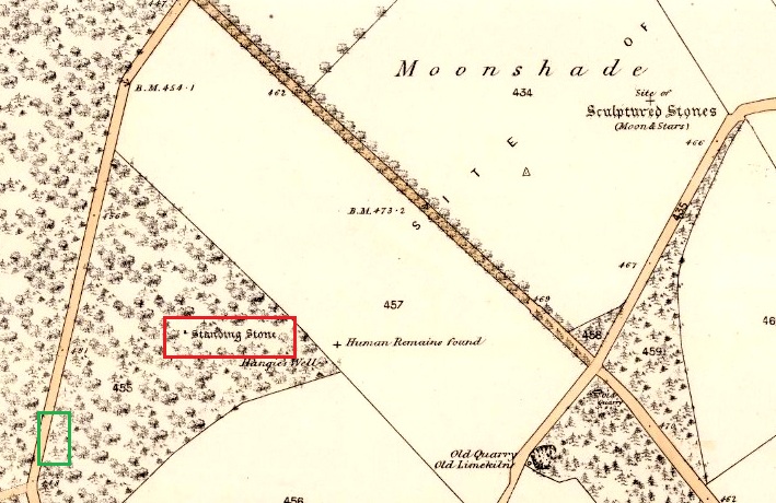
Turn right off the A93 at Cargill onto the side road by Keepers Cottage and up the hill to Gladsfield Wood at the top on your right. Park up at the top side of the Wood and walk straight along the narrow track for around 450 yards and what may be the remains of the stone will be seen between a pair of mature trees.
Archaeology & History
In 1862 the stone was described in the Ordnance Survey Name Book for Perthshire:
‘And about 150 yards from the same object [Hangie’s Well], in a north-westerly direction, there is a small Standing Stone, having the appearance of the ancient monumental standing stones.’
It seems the stone had been removed by the time Fred Coles (1909) came to see it nearly fifty years later. He told us:
“On the day of my visit the mist was so abnormally dense and confusing that it was with considerable difficulty the wood itself was identified; and as its interior is an utter wilderness of trees, shrubs, brambles, broom, wild roses and tall grass, besides being a pheasantry, it is just possible that the monolith searched for evaded my zeal. I think not, however, because, hearing a hedger at work on the Newbigging side of the wood, I made for him; and after plying him with various questions, could get no statement to the effect that he had, though living so near, ever seen any conspicuously tall Stone in the wood.
“On retracing my steps, I searched a fresh portion of the wood, and noticed one biggish block of whinstone lying on the grass in a slight hollow of the ground. It was somewhat cubical, about 2 feet 6 inches square, and fractured. This may he a portion of the former monolith, possibly; and with this dubious result I had to be content.”
In 1967 the archaeologist O.G.S. Crawford described “a sharp-edged boulder standing near the spot marked on the map,” but was not certain if it was the stone. It had no markings on it.
25 in OS map of 1866 showing original position of stone outlined red and position of possible remains of stone in green
Moving on to 2020, and I found the same impenetrable jungle that Coles described more than a century earlier. When a site has been destroyed I can normally take a photograph of where it once was, but not in this case. I continued westward over difficult and potentially ankle snapping terrain that had recently been replanted with conifer saplings, until I got out of the planting area to a line of mature trees next to the track through the wood.
One large elongated stone presented itself that had clearly lain there for many years judging from the moss growth, a short distance away at NO 15641 35478. Could this be the top part of the standing stone, dragged from its original position some 500 feet to the north-east? It is of grey whinstone, heavily veined at the base, with white quartz and tapering to a pointed tip. It has a squarish base measuring approximately 3 feet across by at least 2 feet deep and is some 7 feet in length. It doesn’t look to be natural, so is it a likely candidate for our missing stone? Felled by a man with a hammer and chisel and dragged by a heavy horse to the edge of the field as part of the ‘improvements’, so beloved of nineteenth century landowners…
We can’t prove it is the remains of Hangie’s Stone which may, after all, still lie buried in the boscage…
The possible remains of Hangie’s Stone
The stone in its original position was next to the Roman road from Camelon via Stirling and Muthill to Kirriemuir near to the junction of a road to Inchtuthill Roman Fort, so may have once been a way marker, although it is not of Roman origin.
From Littleborough, take the Ripponden and Halifax A58 road up-uphill till you get to the White House pub near the very top. From here, cross the road and walk along the track below the disused quarry for a coupla hundred yards till you meet with the straight uphill track. Go up here and, near the very top, you’ll see the upright stone right beside the footpath on your left.
Archaeology & History
Aiggin Stone and cairn
This ancient boundary stone has long been an etymological oddity. It aint a prehistoric stone by any means (soz…), though its nature has never truly been decided for sure. Some have posited it as Roman in origin, others that it’s merely a waymarker (in case y’ get lost in the fog up here), others that it’s a milestone, and the more common notion is that it’s a boundary marker of the counties of Yorkshire and Lancashire (it’s position in the landscape presently sits it in Lancashire). As far as I’m concerned, the stone’s late-medieval in nature…
Standing by the old Roman road a short distance from the very top of these high Pennine hills on the Yorkshire-Lancashire border, a faint old Latin cross, plus the letters “I.T.” are etched onto its sides. In the 1930s the stone was found laid in the moorland heather, but was thankfully resurrected in 1933. Since then however, it’s been knocked over a couple more times, but presently stands proudly upright — until the day comes when some other halfwits decide to knock it down again! In its earlier days, James Maxim (1965) described the stone thus:
“It is an irregular block of gritstone 7 feet long, tapering from 2 feet 6 inches to 2 feet wide and it is about 10 inches thick. On one bedding face and a few inches from the top is an incised cross with the ends of the arms slightly expanded. This is 1 foot 4 inches long and 10 inches wide, the horizontal bar crossing the vertical at about 5 inches from its upper end.”
Looking northeast
First highlighted on an engineer’s map from 1800, Herbert Collins (1950) assumes Aiggin to be “a corruption of Agger”, being a Latin word meaning, “a pile, heap, mound, dike, mole, pier – in Roman antiquity, an earthwork or other artificial mound or rampart.” Due to the monolith’s proximity to the supposed Roman road there is great likelihood in it being as such, plus “agger” can also mean a Roman road or military way. Collins cites other possibilities: aggerere, “to bear to a place, to heap up,” or “that which is gathered to form an elevation above a surface” – which is certainly applicable here! James Maxim (1965) thought,
“The name ‘Aiggin’ suggests a pronunciation resembling either ‘edge’ or ‘hedge’ and thus it might mean ‘Edge Stone’. Alternatively it could be derived from the French ‘aguille’, meaning a needle or sharp-pointing rock.”
The view from here is truly excellent — though if you walk to the rocky crags of Blackstone Edge a half-mile to the south (y’ can’t miss ’em from here) and sit by Robin Hood’s Bed, it gets even better! A smaller, possible standing stone can be seen just 200 yards northwest of our Aiggin Stone; with the top of the stone seemingly knocked off in bygone years. Not far from here are the remains of some old hut circles, emerging from beneath the old landscape.
References:
Collins, Herbert C., The Roof of Lancashire, J.M. Dent: London 1950.
Maxim, James L., A Lancashire Lion, J.L. Maxim Trustees: Leeds 1965.
To get here, follow the same directions as you would to reach the curious Green Plain settlement; but just before you reach that, you’ll notice this rather large boulder known as the Eagle Stone right in front of you next to the ever-decreasing stream. Wander down and give it a fondle — you can’t really miss it!
Archaeology & History
Cupmarks on top (image by Graeme Chappell)
Curiously not included in Boughey & Vickerman’s rock-art survey (2003), this large boulder stands just below the ancient ford which crosses Sun Bank Gill and is pitted with a number of cup-marks on its top (though not the 38 we counted when Graeme Chappell and I in the early 1990s), plus a large “bowl”, not unlike the Wart Well on top of Almscliffe Crags and other such sites. Although some of the cups seem natural, others are artificial — as even an English Heritage rock art student could tell you! A small cluster of ‘cups’ are on top of the stone, but a number of them have been etched onto the sloping southern face; a curved line running across the rock-face towards these cups may be natural.
The straight track above you was known as Watling Street in bygone years and was the old Roman road running between Ilkley and Aldborough.
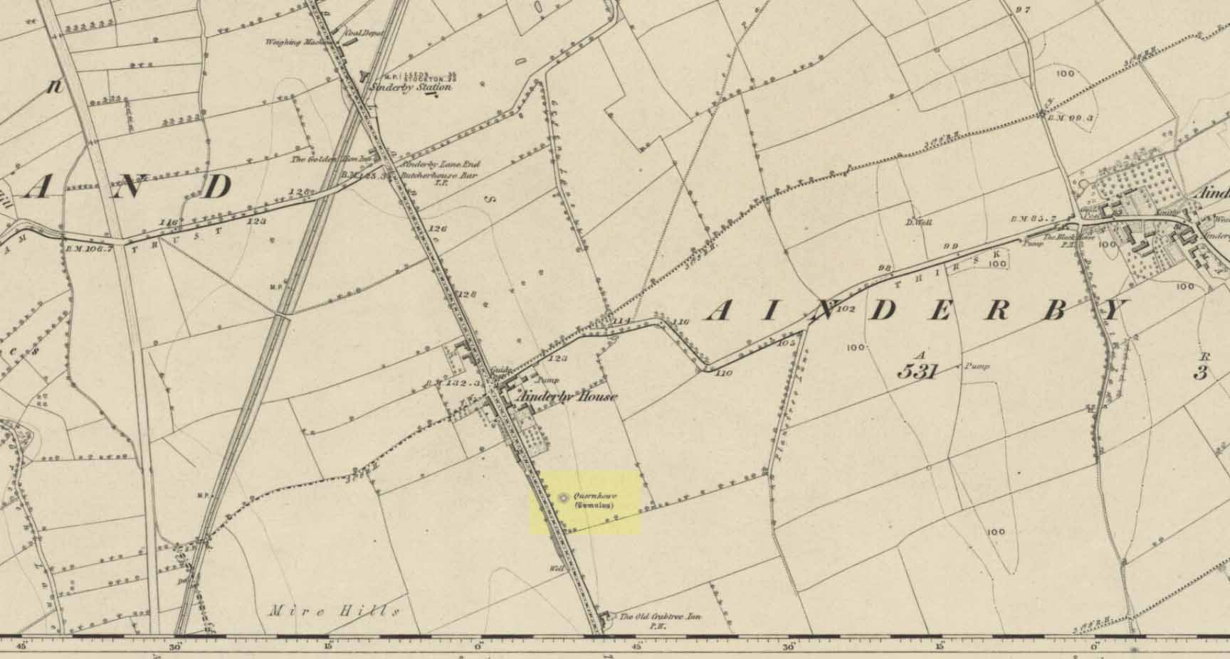
Long since destroyed by the self-righteous advance of the Industrialists, this was a pretty impressive-looking tomb according to the account of D.M. Waterman (1951). Found between the villages of Ainderby Quernhow and Kirklington, right at the side of an important prehistoric trackway—later used by the Romans and known as Leeming Street (on what is now the A1 motorway). Waterman cited it as being “of primary importance in prehistoric times” as it stood on the great plain between the three great henges of Thornborough to the north and those on Hutton Moor to the south, accompanied by a number of other tumuli nearby.
Quernhow tomb on 1856 OS mapThe excavated monument
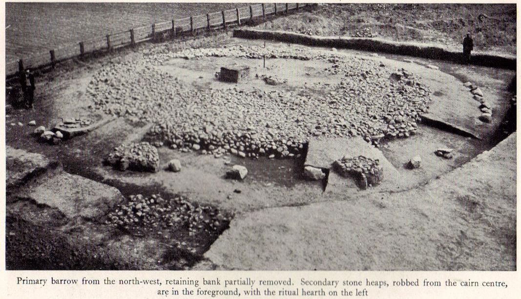
When Waterman and his team arrived here, the barrow “appeared as a low-spread mound, about 3ft in elevation, the exact limits of which were difficult to define,” due to large parts of it being covered over in mud that’d been dumped there by the local land-owner, aswell as erosion due to other farming or industrial activity. But once the archaeologists had stripped the centuries of soil from the damaged surface of the monument, a most impressive site emerged! At the heart of this great burial mound was found “an imposing stone cairn, more or less flat-topped and with a circular constructed face.” He (1951) continued:
“The material of the cairn was composed of cobbles or boulders, all of local geological origin, ranging in size from a few inches up to a foot in diameter or more. A stone considerably larger in size was occasionally encountered , the largest found measuring 23in by 20in and from 3in to 5in in thickness. The stones were heaped up without any deliberate attempt at producing a stable structure and used indiscriminately, irrespective of size or shape, although there was a tendency for the larger stones to occur towards the perimeter of the cairn. Since the cairn itself was built to a flat surface, and the underlying barrow-mound assumed a saucer-shaped profile, the cobbles perforce increased in depth towards the cairn face; at the very centre they were laid one, occasionally two deep, at the face three or four deep, although irregular size and placing precluded any consistency whatsoever in the work. The standard of the building in fact differed considerably throughout the structure. On the northeast and northwest the facing-stones were quite carefully laid, standing to a height of 22in, the work becoming increasingly shoddy towards the south where the construction had so deteriorated that whole sections of the facing had fallen bodily away from the cairn mass, slipping down the tail of the underlying mound…”
Plan of Quernhow
In the middle of the large cairn were found four small pits and a number of small cremations in and around them. There were also found the usual broken remains of pottery, human bones, charcoal, foods vessels and burnt pieces of oak and other vegetation. Near the centre of the cairn was a curious “four poster” of upright stones, “about 1.4ft long and rather less in breadth and thickness (which) suggest, from consideration of their obviously deliberate and careful placing, some significant function in burial ritual.” The four corners of these stones were close to the cardinal points: north, south, east and west.
References:
Waterman, D.M., “Quernhow: A Food Vessel Barrow in Yorkshire,” in Antiquaries Journal, volume 31, 1951.
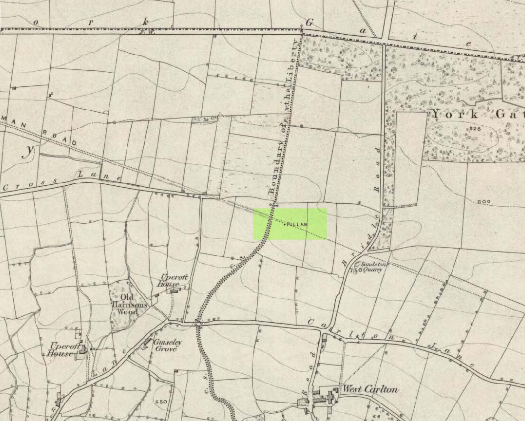
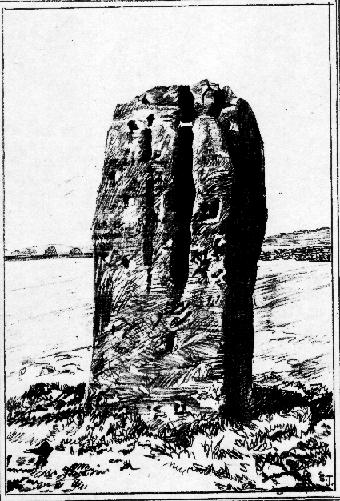
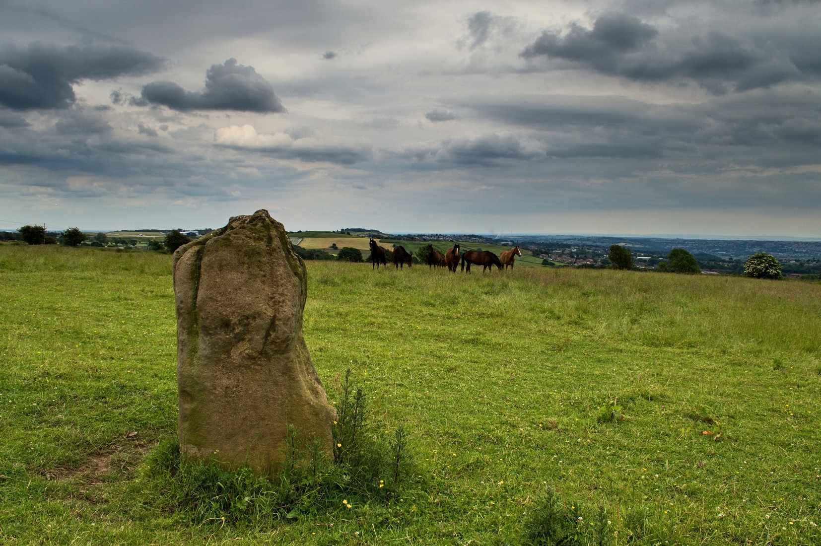
Worth checking this if you aint seen it before! Head up to the back (south-side) of Otley Chevin (where the cup-and-ring Knotties Stone lies sleeping), following the road there and park up near/at the Royalty pub. Take the footpath behind the pub which crosses the fields and once into the second field, head diagonally down to the far-left corner. From here, look over the wall — you can’t really miss it!
Archaeology & History
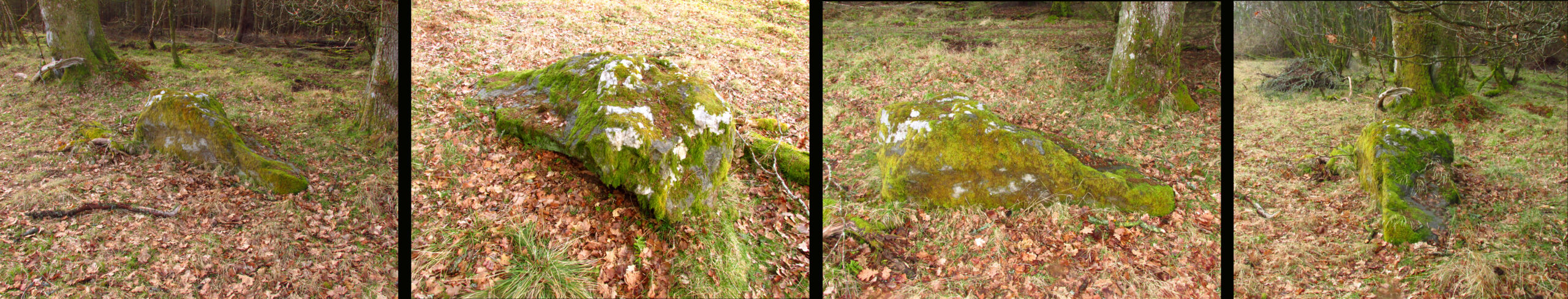
An intriguing site for various reasons. All we have left to see of any value nowadays is this nigh-on 6-foot tall thick monolith, standing alone in the field halfway between West Carlton and Otley Chevin. Completely missed in local archaeological surveys, the place was mentioned briefly by Slater (1880); though it appears to have been first described in detail by Eric Cowling (1946), who suspected the stone may have Roman origins (though didn’t seem too convinced!), saying that:
“near the ground the section is almost oblong, with sides three-feet six-inches by one-foot ten-inches; two feet from top, the section is almost circular.”
The fact that the stone stands very close to the line of an all-but forgotten Roman road that runs right past it added weight to this thought (the road runs towards a Roman settlement a mile east of here near Yeadon). But this standing stone is unlikely to be Roman. More recent evidence seems to indicate a relationship with a now-lost giant cairn about 100 yards to the south. The only remains we have of this place are scatterings of many small loose stones nearby. And it seems a very distinct possibility that the extra standing stones that were once hereby, stood in a line.
The very first reference I’ve found about this site also indicates that there was more than one stone here in the past! In 1720 this site was known as the ‘Boon Stones’; and the plural was still being used by the time the 1840 Tithe Awards called them the ‘Boul Stones.’ Initially it was thought that both words were plural for “bulls” — as A.H. Smith (1962) propounds in his otherwise superb survey — but this is questionable. (see Folklore)
Folklore
A piece of folklore that seems to have been described first by Philemon Slater (1880) relates to the pastime of bull-baiting here, that is –
“fastening bulls to it when they were baited by dogs, a custom…still known to the Carlton farmers” (North Yorkshire).
Cowling (1946) told that he heard the stone was said to be lucky as well as being a source of fertility. This ‘fertility’ motif may relate to the meaning of the stone’s early name, the Boon Stones. Both boon and boul are all-but obsolete northern dialect words. ‘Boul’ is interesting in its association with a prominent folklore character, as it was used as a contemptuous term “for an old man.” Now whether we can relate this boul to the notion of the ‘Old Man’ in British folklore, i.e., the devil, or satan — as with the lost standing stone of The Old Man of Snowden, north of Otley — is difficult to say.
More interestingly perhaps is the word ‘boon’, as it is an old dialect word for “a band of reapers, shearers, or turf-cutters.” This band of reapers ordinarily consisted of five or six people and would collect the harvest at old harvest times. And as the early description talks of Boon Stones, this plurality would make sense. One curious, though not unsurprising folklore relic relating to these boons was described at another megalithic site (now gone) by John Brand (1908), where in the parish of Mousewald in Dumfries,
“The inhabitants can now laugh at the superstition and credulity of their ancestors, who, it is said, could swallow down the absurd nonsense of ‘a boon of shearers,’ i.e., reapers being turned into large grey stones on account of their kemping, i.e., striving.”
Standing stones with the folklore of them being men or women turned to stone is common all over the world. If we accept the dialect word ‘boon’ as the first name of this old stone, there may once have been some harvest-time events occurred here long ago (and this is quite likely). Equally however, we must also take on the possibility that this Bull Stone has always been a loner and that its name came from the now obsolete Yorkshire word, a bull-steann, meaning a stone used for sharpening tools, or a whetstone.
Take your pick!
References:
Bennett, Paul, The Old Stones of Elmet, Capall Bann: Milverton 2001.
Brand, John, Observations on the Popular Antiquities of Great Britain – volume 2, George Bell: London 1908.
Cowling, Eric T., Rombald’s Way, William Walker: Otley 1946.
Jackson, Sidney, ‘The Bull Stone,’ in Cartwright Hall Archaeology Group Bulletin, 2:5, 1956.
Smith, A.H., English Place-Name Elements – 2 volumes, Cambridge University Press 1956.
Smith, A.H., The Place-Names of the West Riding of Yorkshire – volume 7, Cambridge University Press 1962.
Slater, Philemon, The History of the Ancient Parish of Guiseley, William Walker: Otley 1880.