Follow the same directions as if you’re visiting the impressive Fairy Stone carving, then 3 yards east is the Cottingley 2 double cup-and-ring, keep walking past through trees for another 5-6 yards where you’ll come across this reasonably large curved flat stone. Y’ can’t really miss it
Archaeology & History
Cup, with ring faintly visible
This was another carving in the small cluster by the Fairy Stone that I found on my visit here in the 1980s—but it’s a pretty innocuous one to be honest. There’s a faded incomplete “ring” (not really visible on my photos due to pouring rain and very poor light when I was here) with a distinct cup-mark in the middle. Several inches away from the cup-and-ring is a carved line that arcs around it creating an incomplete oval design; and what seems to be a single cup-mark is visible at the top of this oval. Other marks on the stone are both natural as well as recent ‘scratches’.
Some elements of this carving—as with others in this petroglyph cluster—seems to be modern. The cup-and-ring seems to be the real deal, but the ‘oval’ seems to have been added much more recently, perhaps by the scouts who play around in this part of the woods.
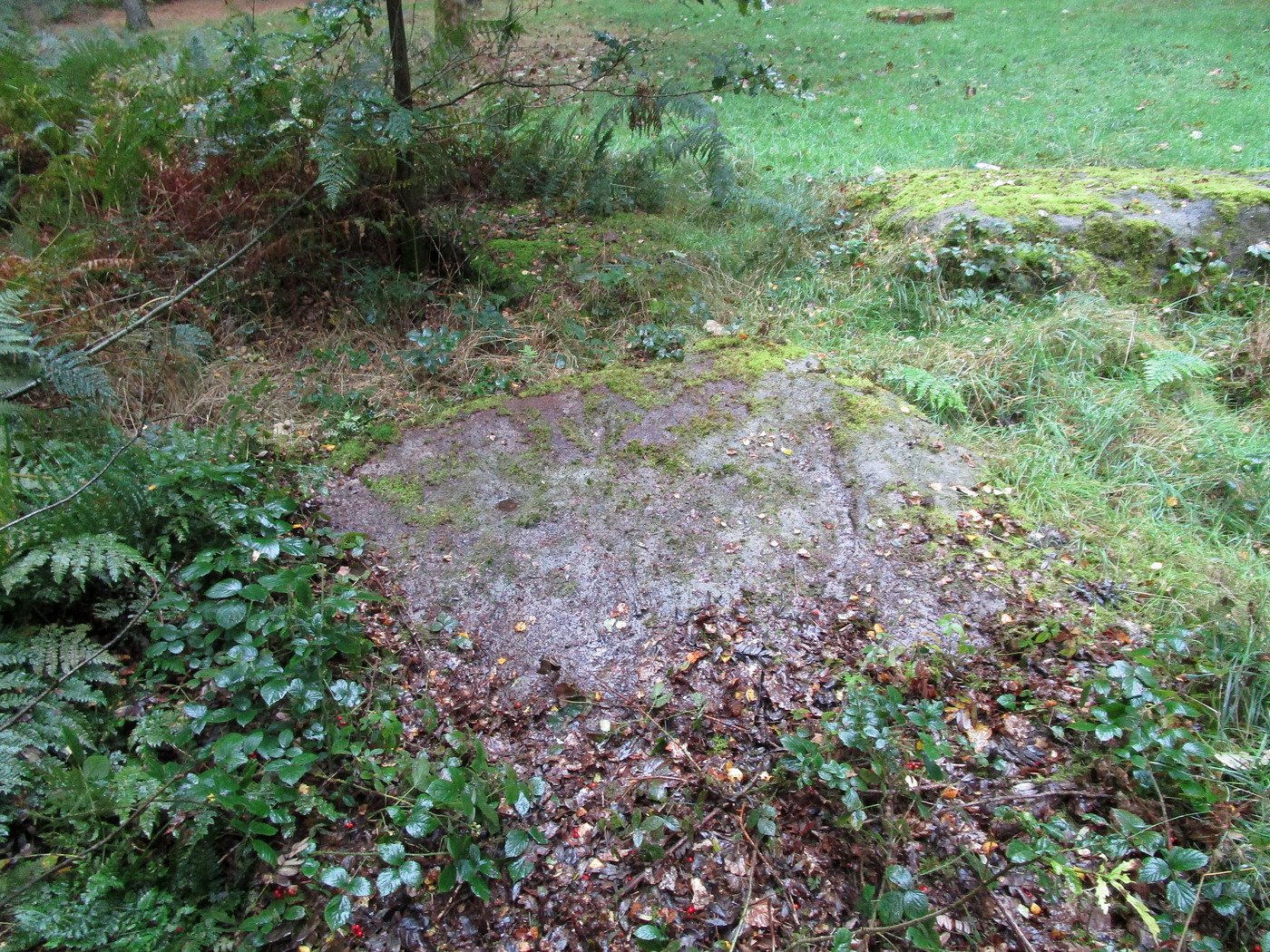
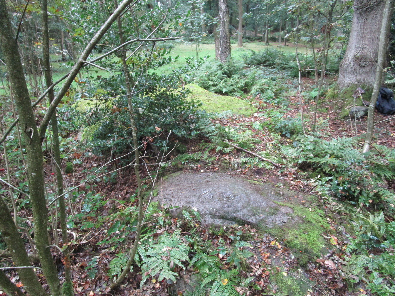
Get yerself to the Fairy Stone, then walk east past the adjacent woodland carvings—numbers 2, 3 and 4—from where you should walk about another 10 yards east across the grass, keeping your eyes peeled for a large flat stone measuring about 6ft by 10ft just as you go back into the tree cover north-side. You’ll find it.
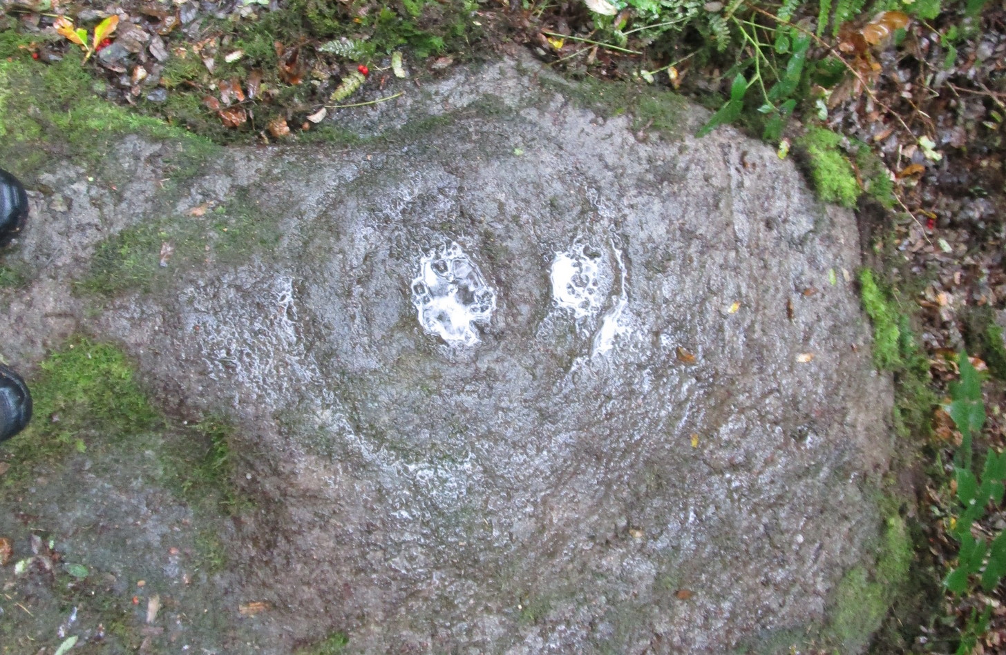
Archaeology & History
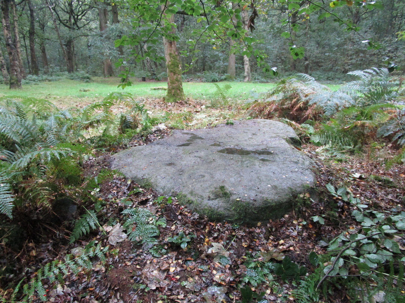
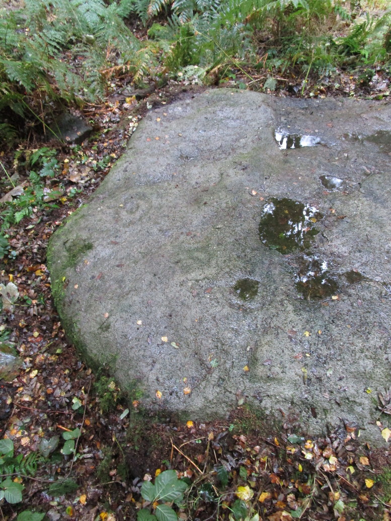
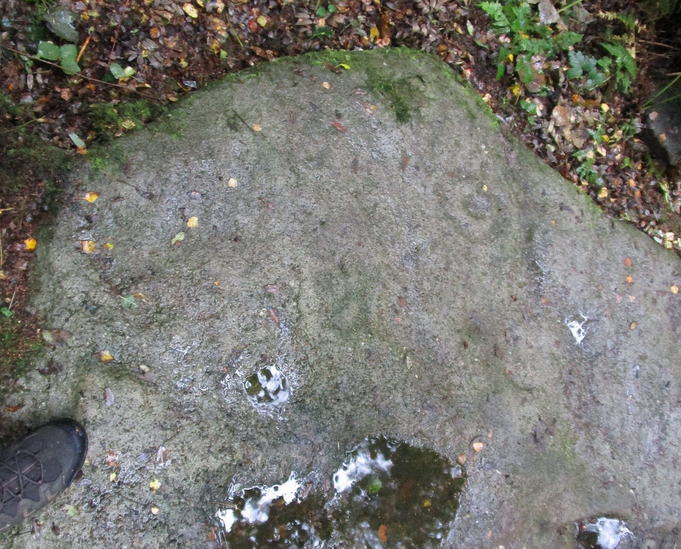
This large carved rock is the easternmost known petroglyph in this small woodland cluster of five. (a sixth one can be found, but it’s several hundred yards east from here) Consisting of two distinct cup-and-rings in relative proximity to each other on the northern section of the stone, this design—unlike others in this group—has a greater sense of stylistic authenticity to it. Despite this, one of the two cup-and-rings seems to be a more recent addition to the rock, as close inspection shows peck marks that aren’t very well eroded as you’d expect on rock of this type if it was truly ancient. The more faded cup-and-ring on its northwestern section looks to have a greater sense of age about it when we look at its erosion level….perhaps…
The 2 Cup & RingsThe 2 cup-and-rings
We have to take into consideration when looking at this carving and the others nearby that possess some quite peculiar design-elements, that this section of woodland is used extensively by boy scouts who do what boy scouts do in their teenage ventures: from making fires, climbing trees and, perhaps, scribing on stones if/when their elders aint looking. It’s an important ingredient that has to be taken into consideration when looking at the more rash motifs hereby—this carving included. The more faded cup-and-ring on this, however, may be the real deal. And hopefully, next time I visit this site, She’ll not be dark and pouring with rain (much though I love such weather), so I’ll be able to get some better photos!
Follow the same directions as if you’re visiting the impressive Fairy Stone carving, then check out the overgrown rock three yards away, to the east. You might have to rummage under the scrubbage to see it, but you’ll find it if you want to!
Archaeology & History
I first found this stone in the 1980s when I’d been shown the Fairy Stone carving which, at the time, was thought to be all alone. But I used the olde adage: “where’s there’s one cup-and-ring, others tend to be“—and found this and several others closed by.
Large messy cup-and-ring
It’s a relatively small, slightly-domed earthfast rock, upon which we find an unusually large cup-and-double-ring design with a carved line running from the large central cup out to the edge of the stone. However, the carved lines that constitute both the inner and outer rings are ‘crude’ in form and style when compared to the vast majority of other British petroglyphs; and for some reason, this aspect of the design has me casting doubts over its prehistoric authenticity. I hope I’m wrong!
References:
Bennett, Paul, ‘Tales of Yorkshire Faeries,’ in Earth 9, 1988.
Bennett, Paul, The Old Stones of Elmet, Capall Bann: Milverton 2001.
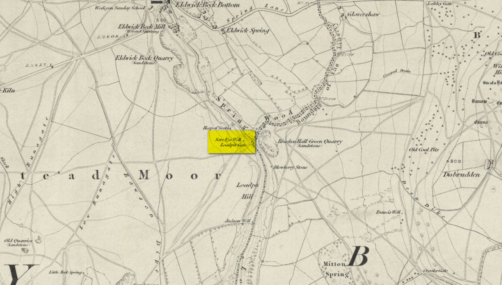
Healing Well (destroyed): OS Grid Reference – SE 1286 4007
Also Known as:
Loadpit Well
Archaeology & History
Sore Eye Well on 1852 map
Descriptions of this site are few and far between, despite it having a meaningful name. First recorded on the 1852 OS-map, in the folklore of our ancestors this was a well that local people frequented to wash their face and it was said that the waters would take away the ills of those suffering poor eyesight or other ocular problems. Rags were left hanging over an old rowan tree as offerings to the spirit of the water, in return for curing the afflicted eyes.
When I first came looking for this as a boy, I was frustrated to encounter the water authority’s metal cover ruining the site completely, leaving nothing of the old well as it once was. Around the metal-cover was evidence of a small rock enclave that would have defined the spring as it emerged from the earth—although it was barely noticeable. The remnants of a small path just to the right of the main footpath that reaches up the hillside is apparent, leading to the well. Below it were the remains of a large, water-worn flat rock, with other stones set to its sides, where the water used to flow and be collected, but today everything’s dried up and there’s little evidence of it ever being here.
References:
Shepherd, V., Historic Wells in and Around Bradford, Heart of Albion: Wymeswold 1994.
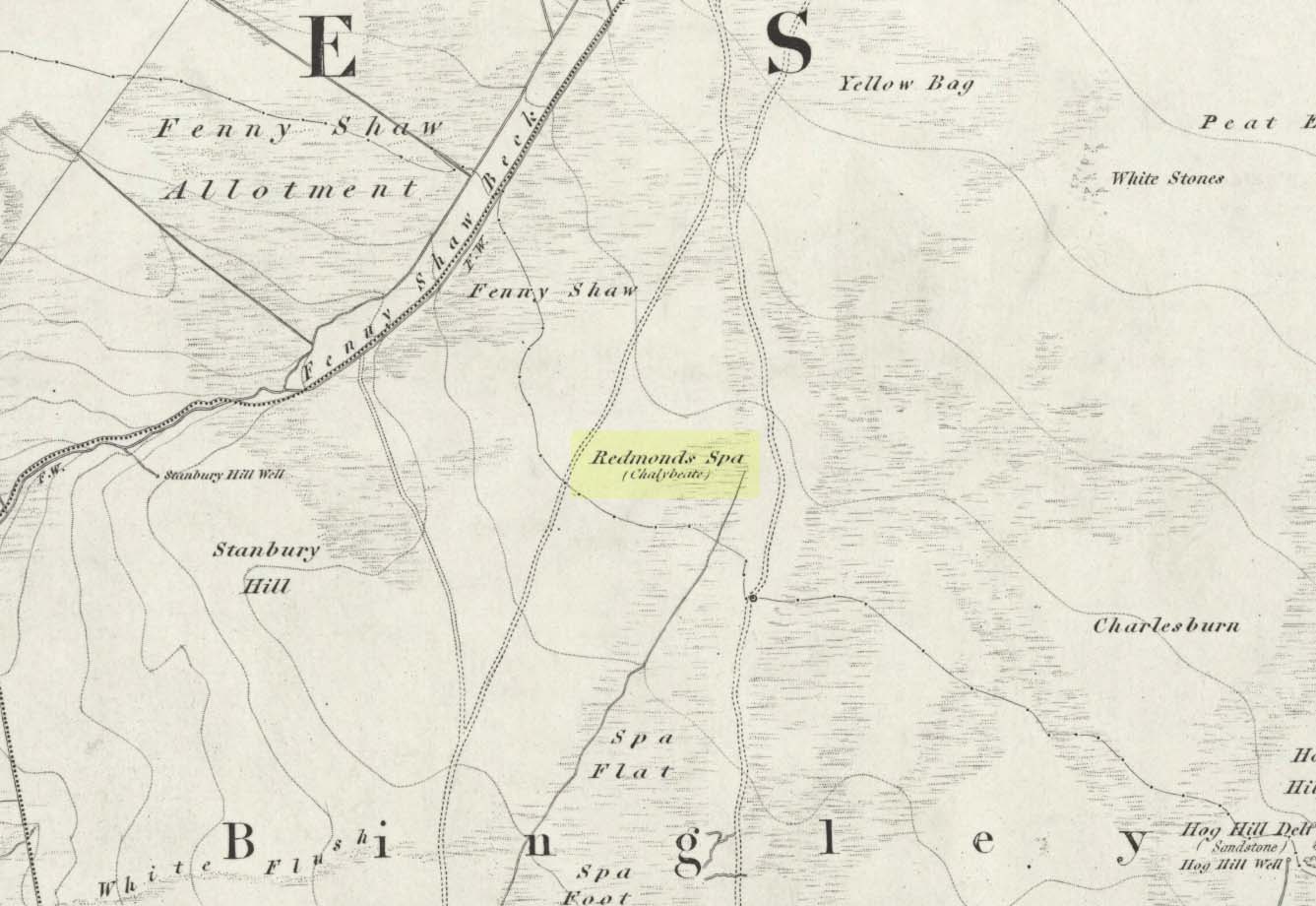
From East Morton village, take the moorland road, east, and up the steep hill. Where the road just about levels out there’s a right turn, plus (more importantly!) a trackway on your left which leads onto the moor. Walk up this track for ⅔-mile until you get to the point where the moorland footpath splits, with one bending downhill to an old building, whilst the other smaller footpath continues on the flat to the north. Go up here for 400 yards then walk off-path, right, for about about 150 yards. But beware – it’s boggy as fuck!
Archaeology & History
On this featureless southern-side of Rombalds Moor, all but lost and hidden in the scraggle of rashies, a very boggy spring emerges somewhere hereabouts. I say hereabouts, as the ground beneath you (if you can call it that!) is but a shallow swamp and its actual source is almost impossible to locate. If you want to find the exact spot yourself, be prepared to put up with that familiar stench of bog-water that assaults our senses when we walk through this sort of terrain. Few are those who do, I have found… But somewhere here, amidst this bog—and still shown on the OS-maps—is the opening of what is alternatively called Redman’s or Richmond’s Spa. We don’t know exactly when it acquired its status as a spa-well, but the 18th century Halifax doctor, Thomas Garnett—who wrote the early work on the Horley Green Spa—appears to be the first person to describe it. Garnett (1790) said how the place:
“was first mentioned to me by Mr W. Maud, surgeon, in Bradford, who went with me to see it. It is situated on Romalds-moor, about two or three miles from Bingley, and goes by the name of Redmire-spaw. The access to it is by no means good; the ground about it being very spongy and soft. On the bottom and sides of the channel is deposited an ochrey matter, of a very fine, bright, yellow colour; and which I believe is used, by the country people in the neighbourhood, to paint their houses. It sparkles when poured into a glass and has a taste very like the Tewit-well at High-Harrogate; which water it very much resembles in all its properties, and seems to be about the same strength… This water seems to hold a quantity of iron dissolved by means of fixed air. Its taste is very pleasant; it is said to act very powerfully as a diuretic, when drank in considerable quantity, and may prove a useful remedy, in cases where good effects may be expected from chalybeates in very small doses; the fixed air, and even the pure water itself may be useful in some cases. It is, however, necessary to drink it at the well, for it seems to lose its iron and fixed air very soon.”
I’ve drank this water, and believe me!—it doesn’t quite taste as pleasant as Mr Garnett espouses! Its alright I s’ppose—but drinking water from a bog isn’t necessarily a good idea. That aside, I find it intriguing to hear so much lore about such a little-known spring; and it is obvious that the reputation Garnett describes about this spa came almost entirely from the local people, who would have been visiting this site for countless centuries and who would know well its repute. Below the source of the well the land is known as Spa Flat, and slightly further away Spa Foot, where annual gatherings were once held at certain times of the year to celebrate the flowing of the waters. Such social annual gatherings suggests that the waters here were known about before it acquired its status as a spa—which would make sense. The remoteness of this water source to attract wealthy visitors (a prime function of Spa Wells) wouldn’t succeed and even when Garnett visited the place, he said how he had to travel a long distance to get here.
The origin of its name was pondered by the great Harry Speight (1898) who wondered if it derived from the ancient and knightly Redman family of Harewood, whose lands reached over here. But he was unsure and it was merely a thought. As an iron-bearing spring (a chalybeate) you’d think it might derive from being simply a red mire or bog (much like the Red Mire Well at Hebden Bridge), but its variant titles of apparent surnames casts doubt on this simple solution.
No one visits the place anymore. Of the countless times I’ve wandered the moors, rare have been the times when I’ve seen folk anywhere near this old spring. It is still coloured with the same virtues that Garnett described in the 18th century: the yellowish deposits, the boggy ground, much of which reaches to the truly dodgy Yellow Bog a short distance north and which should be completed avoided by ramblers after heavy rains (try it if y’ don’t believe me—but you’ve been warned!).
Cist (destroyed): OS Grid Reference – SE 1196 3824
Archaeology & History
The remains of a prehistoric tomb existed near the foot-bridge on the south-side of the canal at Dowley Gap, but was destroyed during the building of the sewage works there in 1951. It was reported by a Mr Duncanson to Bradford’s Cartwright Hall archaeology group, who told how they accidentally uncovered it during construction work. He told that the
“stone cist (was) about 3½ feet long and 1½ feet deep and was found on rising ground at the western end of the works where the storm water tanks are now situated.”
We obviously don’t know the age of the cist, but such grave monuments are most commonly Bronze Age. The existence of the Crosley Wood Iron Age enclosure 4-500 yards NNW and the prehistoric circle 800 yards east are the nearest other known early period monuments.
References:
Jackson, Sidney, “Stone Cist at Bingley,” in Cartwright Hall Archaeology Group Bulletin, 3:6, 1958.
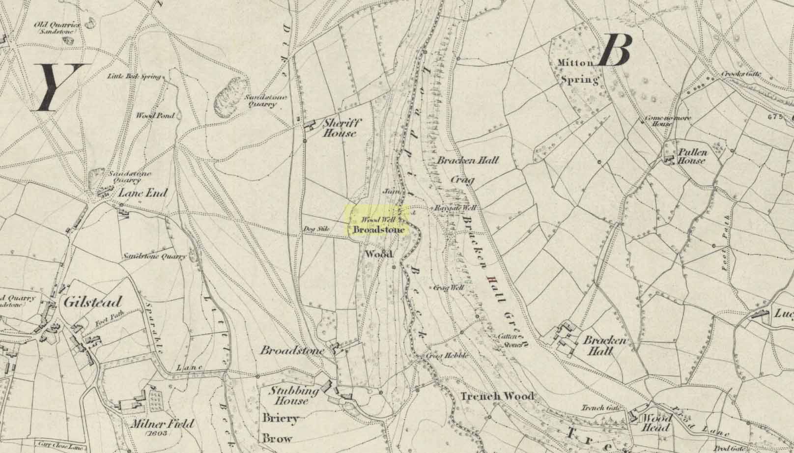
Best reached by going up Shipley Glen, to the Brackenhall Circle enclosure; keep going for a couple of hundred yards and then drop down into the trees, taking the directions directly to the Cloven Hoof Well. Just past the well, a small footpath leads you downhill towards the large stream at the bottom, where there’s a rocky crossing (an old ford). Go over here and, barely 50 yards upstream to your right, a large singular moss-covered boulder is set back, just a few yards above the stream with a small pool in front of it. That’s it!
Archaeology & History
The ‘directions’ to find this might seem a little confusing to locals at first. This is because the whereabouts of the Wood Well is on the eastern boundary edge of Gilstead – which is down at the bottom of Shipley Glen. The steep muddy hill above it is almost always slippy and wet through, so it’s easiest to approach from the Baildon side.
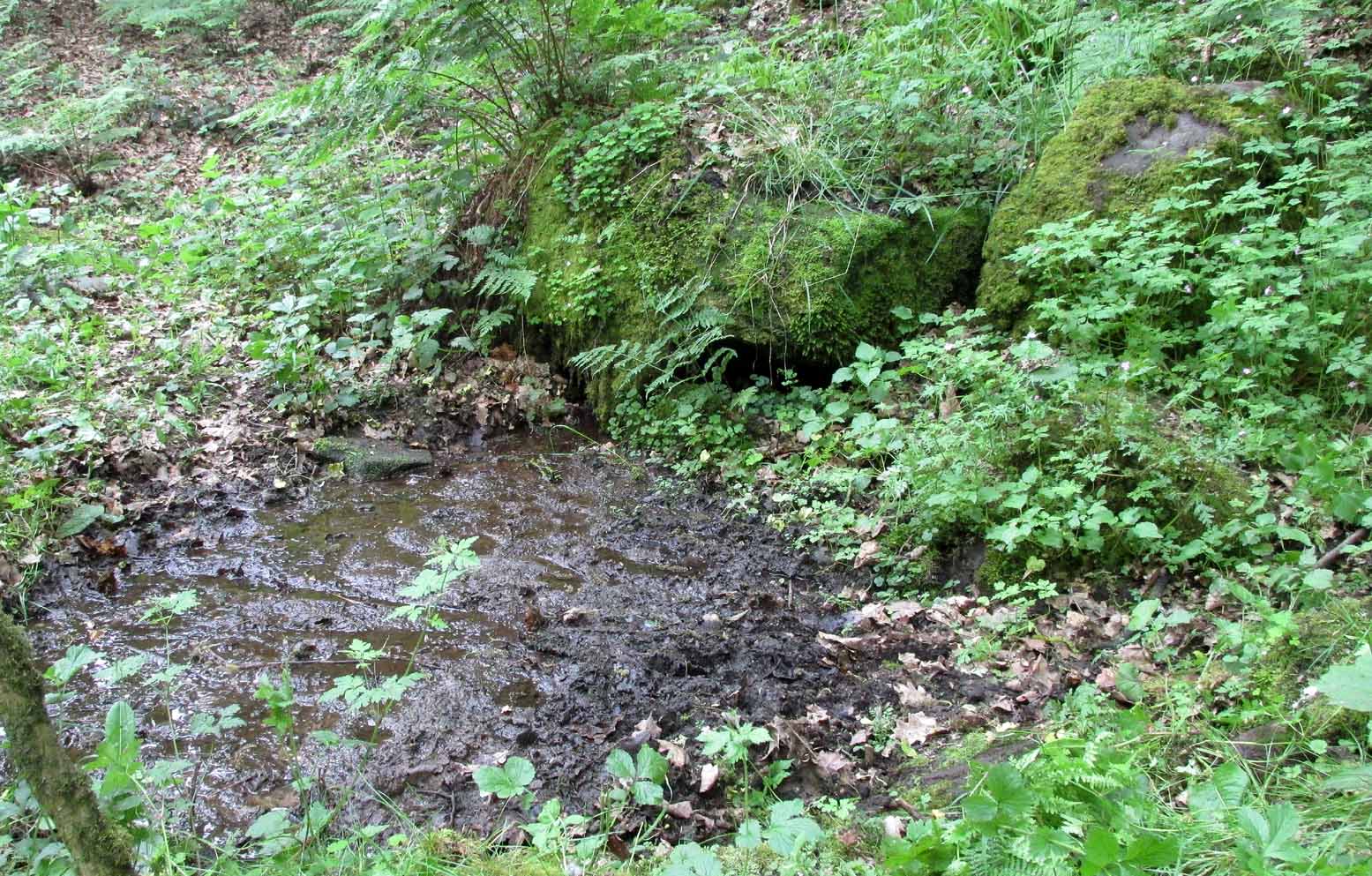
The shallow muddy waters in a hot summer
The site is shown on the 1852 map of the area, but I can find no written material telling of its qualities. If it ever had any medicinal virtues, they have long since been forgotten. Whilst the water here is fresh and drinkable, in times of drought and low rainfall the water subsides and leaves only a muddy pool – just as it was when I last visited, making it quite undrinkable. But to me, the main aspect of this site is its natural spirit, its locale, as it’s surrounded by unerring hues of rich greens, cast out by the landscape of mosses prevalent in a region almost bereft of such voices. If you like y’ wells – check it out!
Sacred Well (destroyed): OS Grid Reference – SE 0973 4091
Archaeology & History
Lund Well on 1852 map
Once found in a cluster of three little wells all very close to each other near the top of the field where the Crossflatts roundabout joins up with the Aire-Valley trunk road, this is an intriguing site if you happen to be a pagan, or have an interest in druidism — and for one main reason: its name. When I first came across a reference to the place about 25 years ago, the only piece of information I could find about it came from the arduous detailed researches of the Victorian industrial historian J. Horsfall Turner who, unfortunately, neglected to record much of the fading folklore in the region at his time. Marked on the 1852 6-inch Ordnance Survey map, ‘Lund’ was a bit of an etymological curiosity, and Mr Turner (1897) thought the well’s name was little other than that of a local mill owner, whose nickname was ‘Lund’ Thompson. He was guessing of course…and I thought little more about it…
Years later when looking through A.H. Smith’s (1961-63) magnum opus on the place-names of West Yorkshire, I found that he didn’t include the Lund Well in his survey. However, an eventual perusal of Kenneth Cameron’s (1996) work told that in Old Norse place-names (and there is a preponderance of such places scattering Yorkshire and Lancashire), lund or lundr was a “‘small wood, grove,’ also had a meaning, ‘sacred grove’.” The word is echoed in old French, launde, meaning ‘forest glade’. In A.H. Smith’s (1954) earlier etymological magnum opus he said that the word derives from a “small wood, grove, also a sacred grove, one offering sanctuary.” However, Margaret Gelling (2000) urged caution on the origin of lund as a sacred grove and erred more to the usual English tendency of depersonalizing everything, taking any animistic attribution away from its root meaning; but we must urge caution upon her caution here! Neither Joseph Wright (English Dialect Dictionary, vol.3 1905) nor William Grant (Scottish National Dictionary, vol.6, 1963) have entries for this word, so we must assume the Scandinavian root word origin to be correct.
One vitally important ingredient with the Lund Well is its geographical position. For across the adjacent River Aire the land climbs uphill—and a few hundred yards above we reach the well-known and legendary Druid’s Altar, with its Druid’s Well just below. This association is what suggests our Lund Well may have had a real association with a “sacred grove of trees”, as—despite us knowing very little about them—we do at least know that druids performed rites in sacred groves. In Greenbank’s (1929) historical analysis of the Druid’s Altar, he was left perplexed as to the origin of its name as all early accounts and popular culture assigned it this title, and so he opted for the probability that the druids did indeed once perform rites here. If this was true, then our seemingly innocuous Lund Well once had a much more sacred history than anyone might have thought. Sadly, through their usual ignorance of such matters, the industrialists destroyed it….
References:
Cameron, Kenneth, English Place-Names, Batsford: London 1996.
Gelling, Margaret, Place-Names in the Landscape, Phoenix: London 2000.
Greenbank, Sydney, The Druid’s Altar, Bingley, R.G. Preston: Bingley 1929.
Smith, A.H., English Place-Name Elements – volume 2, Cambridge University Press 1954.
Smith, A.H., The Place-Names of the West Riding of Yorkshire – 8 volumes, Cambridge University Press 1961-63.
Legendary Rocks (destroyed): OS Grid Reference – SE 0886 4479
Archaeology & History
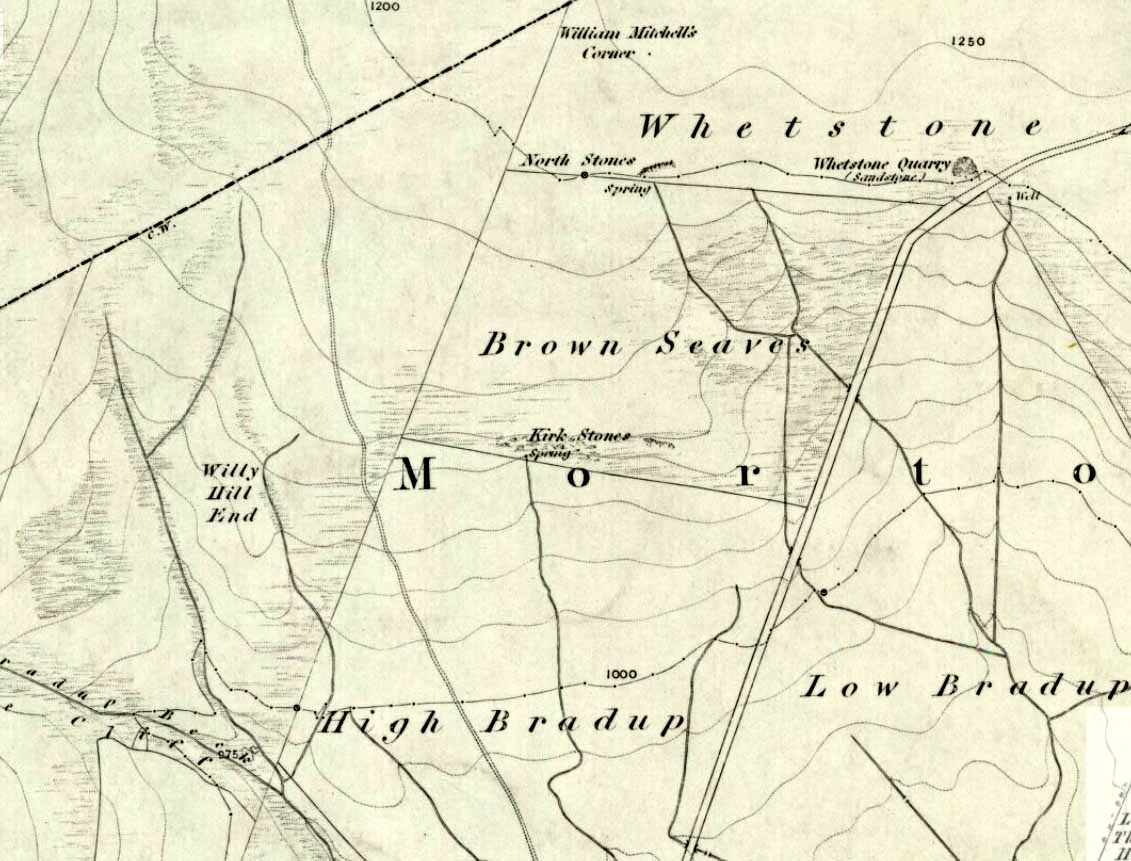
Kirk Stones on 1851 map
A place-name that is still recognised on modern Ordnance Survey maps, even though the original site giving rise to it was all but destroyed some one hundred-and-fifty years ago. Derived from the old word kirk, meaning a church or sacred site, no christian remains of any kind have ever existed here and so we must presume an earlier, more heathen site of sanctity (an abundance of prehistoric petroglyphs exist very close by). The singular reference detailing the nature of these Kirk Stones is in J.A. Busfield’s (1875) rare tract on the history of Upwood, in the parish of Bingley. Upwood Hall was built by the Busfield family and, as the author tells,
“one of the most striking features in the vicinity at this age [c.1800, PB] was the fine range of magnificent rocks called Kirkstones, which had existed for countless ages. These grand rocks, towering one above another, extended along the whole southern boundary of the [Whetstone] Allotment on the left of the road to Ilkley, and were really a fine object, but alas!, through the ignorance or stupidity of the agent Colonel Bence, the “Crags of Kirkstone” were broken up and disposed of in the construction of the Bradford Water Works about the year 1854.”
Sadly we have neither illustrations nor other references to these fine sounding sentinels.
Undoubtedly the Kirkstones were a natural feature, despite their venerated title. It would have been their very appearance that gave rise to their revered title, as in the great and contorted rock masses seen at Brimham Rocks which, from Bensons’s description, these Kirk Stones seem reminiscent. The only piece of extant lore to these stones is that the uprights that went into making the recently destroyed Bradup stone circle a short distance south of here, came from this sacred outcrop. It seems reasonable to assume that they played an important role in the magickal history of these hills when they were scattered with forest.
The Kirk Stones aligned along the equinox axis to the Black Knoll standing stone less than a mile [1.4km] due east.
References:
Bennett, Paul, The Old Stones of Elmet, Capall Bann: Milverton 2001.
Busfield, Johnson Atkinson, Fragments Relating to a History of Bingley Parish, Bradford 1875.
Smith, A.H., English Place-Name Elements – Part 2, Cambridge University Press 1956.
A little-known early christian relic found in the driveway to East Riddlesden Hall was saved and propped up in the stable floor at the back. In 1984 however, the National Trust got round to moving it and bringing the relic to greater public attention by putting it on display in the great hall of the building. (I think you’ve gotta pay to go in and see the stone these days – which is a bittova pain if you just want to examine the carving)
Old photo of the carved stone (after Margaret Faull)
Measuring just 1 foot across and 2 feet high and carved on all sides, the design is all too familiar to those of you exploring early christian or late-Celtic art forms. Executed sometime between the 5th-10th century, on the main face of the cross we have the traditional ‘Celtic’ interlacing, with a bird-figure emerging on or around an early ‘cross’ symbol. There are a variety of interpretations of this, but none relate to any modern christian mythic structures. Indeed, we should cautiously reflect on the more pre-christian nature of this design: carved as it was at a time when the spirit of the natural world (animism) was endemic amongst all people. This carving would in some way reflect such implicit subjectivity, though perhaps have had emergent ideals relevant to the christian cult within it. However, we should be cautious about this christian idea, despite it being much in vogue by prevailing groups of consensus trance historians.
References:
Faull, Margaret L., “The Display of the Anglo-Saxon Crosses of the Keighley Area,” in Transactions of the Ancient Monuments Society, New Series no.30, 1986.