Dumpit Hill B, Hebden, Grassington, North Yorkshire

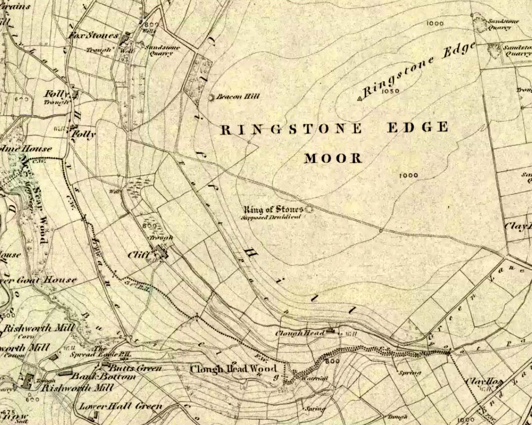
Stone Circle:  OS Grid Reference – SE 0307 6406

Getting Here

Follow the directions to reach the Dumpit Hill A circle.  From here walk about 100 yards ENE till you see an arc of small upright stones.  If the heather’s in full growth it’s highly unlikely you’ll see anything; but if the heather’s been burnt away, the site’s worth looking at.

Archaeology & History

As with the small companion Dumpit Hill A circle more than 100 yards to the southwest, this site of similar dimensions was first reported by Arthur Raistrick in 1963, and then described — albeit briefly — in H.G. Ramm’s “Yorkshire Archaeological Register” for 1964, as “33ft in diameter. One third of the circle robbed but other stones standing.”  And apart from that (with a repeat of the same info in Burl’s [2000] magnum opus) little else has been said.  But there’s quite a bit more to this place than what our mentors have written…

Northern arc of circle, with stones A, B, C & D
Dumpit B Stone Circle (white sticks showing position of stones)

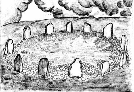
In a team visit to the site last week, it was Paul Hornby who called our attention to Dumpit Hill B.  Thankfully the heather had been burnt back several months earlier, fortunately allowing us a better assessment of the place than Mr Raistrick’s initial survey forty years ago.  Instead of just the 3 stones that he found here, we uncovered a near-complete ring of eight stones, arranged in a pretty decent circle (Alexander Thom would have classed it as a Type 1 circle).  Paul’s attention was first drawn to an arc of three obvious upright stones and another laid down along the same arc.  This arc then turned out to be a semicircle when he found another stone laid half-covered in the peat.

Western stones D & E
Stone F

But then it seemed, if this was an authentic stone circle, we were gonna struggle to see the rest of it as the deep heather had grown up over the southern side of this semi-circle of stones.  But thankfully, with just a little bit of stomping on the ground in the right areas, three other stones of similar size and stature were located and within just a few minutes this small arc of stones had become a full prehistoric ring — except perhaps on the eastern side, where there was a distinct gap in the monument.  Michala Potts and Paul did come across a couple of stones in this “missing” section, but they were just small rocks and didn’t account for an expected 9th stone.  If such a stone ever stood at this eastern point in the circle, it remains unfound.

Two of the stones (G & H) that were initially covered in heather, after we’d carefully peeled the vegetation back, had what seems like small packing stones at one end, where it seemed obvious they had stood upright.  It was tempting to carefully stand each stone back up into position, but we managed to overcome the temptation!  None of the stones are higher or longer than 3 feet.  At least three of them seemed to have been set along their longer axis rather than being set in the tall upright position — but again, this needs verifying by excavation.  (With good evidence, some students posit that upright stones are male; rounded, wider stones are female — though such a lay-out here seems unlikely)

Stone G
Stone H

An additional curiosity was found in the middle of the circle, where there was a small but distinct scattering of stones, very much like a denuded cairn.  If this turns out to be the case (as seems likely) it’d mean a new classification for this monument.  We could do with having another look at this place the next time the heather’s been burnt away, enabling us to find out more about its nature and function.

…And if you walk west down the slight slope, over the couple of small drainage-ditch streams (which they really should stop cutting into our moorlands) and then up the slight slope towards the trackway, stopping some 20 yards before it, you’ll find you’ve walked right into the middle of a previously undiscovered Bronze Age enclosure, or settlement: the Dumpit Hill enclosure.  It’s pretty impressive aswell! (more on that in due course)

References:

  1. Burl, Aubrey, The Stone Circles of Britain, Ireland and Brittany, Yale University Press 2000.
  2. Ramm, H.G., “Yorkshire Archaeological Register, 1964,” in Yorkshire Archaeological Journal, part 163, 1965.

ACKNOWLEDGEMENTS: Huge thanks again to Dave Hazell, Paul Hornby and Michala Potts in seeking out & helping with this and the adjacent sites!

© Paul Bennett, The Northern Antiquarian


Acrehowe Circle, Baildon Moor, West Yorkshire

Ring Cairn:  OS Grid Reference – SE 14245 40686

Also Known as:

  1. Coll’s Burial Mound
  2. Rerehowe

Getting Here

Acrehowe site on 1852 map

Go up through Baildon centre and head onto the moors. Crossing the cattle-grid, a coupla hundred yards further up, turn left. Past the small reservoirs on your left, another 100 yards or so and you reach the brow of the hill.  As you begin going down the road, there’s a small car-park right by the roadside.  The curious remains of the earthworks at the side of the old circle are discernible in the grassland right to its side.

Archaeology & History

Illustrated on the 6-inch OS-map of 1852 as “Site of a Barrow” (similar to how it appears in the image drawn here by Mr. C.N.M. Colls) a short distance below Pennythorn Hill top, there are still considerable traces of the earthworks surrounding the east and southern sides of what was once some form of ring cairn or tumulus that was once at this prominent place in the landscape.

Aerial view of siteThe site was first explored by Mr Colls in 1843 (his results were reported a few years later), who found a loose double-ring of stones, fifty feet across, surrounded by a shallow trench which was most notable on the south and east sides. Two urns were also uncovered near the centre of the ring, nearly two feet down, containing the cremated remains of people.  A few years later, the Leeds historian James Wardell (1869) told a most fascinating note about what happened during their excavation, saying:

“This…examination was attended by a circumstance not soon to be forgotten by the persons engaged therein (on the excavation). They had almost reached the place where the broken urn and bones were deposited when, at once, such a fearful storm of thunder, lightning and rain came on, that they were not only considerably alarmed, but driven from the Common to seek shelter in the village.”

Colls’ 1846 sketch

We hear this sorta thing at many of our ancient places!

Colls 1846 plan

One anonymous writer in 1955 described the site as a ‘stone circle’, and a number of subsequent archaeologists copied this without question; but in all probability this site was more typical of an old cairn circle or ring-cairn, similar in size and design to the Roms Law circle two miles north of here.  However, the earthworks at its side give the impression of some sort of exaggerated hengiform enclosure.

The place-name element howe strongly indicates a burial site and is a suffix found at many prehistoric tombs across northern England.  The prefix ‘acre’ may relate to “a plot of arable or cultivated land, a measure of land (an acre) which a yoke of oxen could plough in a day” (Smith 1956), or may be a corrupted form of the Old English word, ‘acen’, relating to oak trees.  Early literary examples of the place-name would enable a clearer understanding of the prefix element here.

References:

  1. Anonymous, Colls’ Burial Mound Stone Circle, Baildon Moor, Museum Leaflets: Bradford 1955.
  2. Baildon, W. Paley, Baildon and the Baildons (parts 1-15), St. Catherines: Adelphi 1913-26.
  3. Barnes, Bernard, Man and the Changing Landscape, Eaton: Merseyside 1982.
  4. Bennett, Paul, The Old Stones of Elmet, Capall Bann: Milverton 2001.
  5. Colls, J.N.M., ‘Letter upon some Early Remains Discovered in Yorkshire,’ in Archaeologia, 31, 1846.
  6. Collyer, Robert & Turner, J.H., Ilkley: Ancient and Modern, William Walker: Otley 1885.
  7. Smith, A.H., English Place-Name Elements – volume 1, Cambridge University Press 1956.
  8. Wardell, James, Historical Notes of Ilkley, Rombald’s Moor, Baildon Common, and other Matters of the British and Roman Periods, Joseph Dodgson: Leeds 1869. (2nd edition 1881)

© Paul Bennett, The Northern Antiquarian


Reddicar Clough, Hallam Moor, South Yorkshire

Long Cist:  OS Grid Reference – SK 2624 8688

Also Known as:

  1. Ash Cabin Long Cist

Getting Here

Despite a footpath being marked on the OS map, there’s none I could find and the only way to get there is to make your way through the heather.  Park at the Wyming Brook nature reserve car park on Redmires road, take the signposted path besides the notice board and follow the line of the dry stone wall. Go through the gate and continue till you come to the end of the wall where a path leads off to your left through the broken wall, follow the path through the boggy bit and head uphill till you get to the highest point of the path by another wall with a path the other side.  From here it gets a little tricky! You’ll now need to go off path heading NNE and down hill till you come to the post-and-wire fencing where you should pick up a slight path heading WNW (your left) and head for the high point about half a mile in front of you. Just before you come to the high point you’ll have to cross the stream (easily done). The cist lays on the flat ground just beyond the brow of the rise.

Archaeology & History

A long cist around 3 feet wide and 6 feet long in a well preserved condition aligned almost — but not quite — East/West on a prominent position on Hallam Moor, commanding views over Ash Cabin flat, Rivelin Valley and the A57 road.  The only restricted view is to the northwest, where the moor rises then drops down again towards the Headstone.

There are 3 side-stones still in situ: the largest around 1 metre tall, the others still in place being about 70cm.  The stones that would have made up the rest of the walls lay close by.

When you’re at the site it’s obvious why it’s in this location: the views are spectacular and afford excellent views of the surrounding area.  A burial site with a vista truly fit for a king!

Archaeologically there’s not much info kicking around that I can find and I’m indebted to Stubob for alerting me to it’s presence.  It’s very unlikely you’d be walking this area for any reason other than to visit the site, as there are decent paths across the moor to the most popular site in this area, the Headstone off to the North West.  Remains of the Ash Cabin Flat stone circle are about 750 yards southeast of here.

A real gem of a site and a “must see” if your in the area.

© Geoff Watson, The Northern Antiquarian


Ash Cabin Flat, Hallam Moor, South Yorkshire

Embanked Stone Circle:  OS Grid Reference – SK 26940 86268

Getting Here

Follow Redmires road till you come to Wyming brook nature reserve and use the free parking facilities there.  From the car park you need the signposted path to the right of the notice board, the first one not the one by the metal barrier; climb the rocky steps and follow the line of the dry stone wall to your left, and after around 50 metres you’ll pass through a wooden gate.  You then continue following the wall as it heads downhill and the wall becomes broken.  Here you should notice a path that goes through the broken wall off to your left: don’t take it but continue another 50 metres or so, then turn 90° to your right facing the moorland.  The circle is around 50 metres into the heather.

Ash Cabin Flat Stone Circle – as of 26/5/09

Archaeology & History

A fairly well preserved late neolithic or early Bronze age embanked stone circle located in a sea of heather on Ash Cabin Flat on the Western outskirts of Sheffield and rediscovered in 1981 due to the moor being burnt back.

The site is oval in shape and around 9m x 7m diameter to the outer edge of the bank.  The banking is well preserved and shows there was no entrance to the interior.

There are around a dozen stones within and on top of the bank but it’s uncertain whether they are circle stones or packing stones from the bank.  English Heritage have recorded 5 of the stones, 2 still standing, as stones that once stood making up the circle.

If you visit any time soon (23/11/09) you’ll find the moor has been burnt back again giving an excellent view of the site, when the heather is in full flow it’s as high as the highest stones making not only finding the circle nigh on impossible to find but also defining the site very difficult.

Additional Notes:

Editor – 1.12.9. – Following a visit to this site in the company of Megadread recently, we found what appears to be a number of other cairns on the flat moorland plain around this seeming cairn-circle site.  There also appeared to be distinct evidence of ancient walling. Further archaeological evaluations are required here.

References:

  1. Burl, Aubrey, The Stone Circles of Britain, Ireland and Brittany, Yale University Press 2000.

© Geoff Watson, The Northern Antiquarian


Ringstone Edge, Barkisland, Ripponden, West Yorkshire

Ring Cairn:  OS Grid Reference – SE 04436 18247

Also known as:

  1. Ring of Stones
  2. Wolf Fold
  3. Wolf Stones

Getting Here

Ring of Stones on 1854 map

From Ripponden, taken the steep road up to Barkisland, but at the crossroads just before the village, turn right (south) and keep going for a mile till you reach the reservoir.  At the far-end of the reservoir, take the track down by its side and follow the footpath that bends round the edge of the grasslands.  Go up onto this small moorland and,  once you’re on the level, head towards where you’ll see a large pile of stones a coupla hundred yards away.  That’s it!

Archaeology & History

Artist’s impression of site (© Inmaculada Ibanez-Sanchez)

If we visit this site today, all we are left with is a scattered mass (or perhaps that should that be ‘mess’) of many hundreds of stones: the last remnants of what once would have been a proud circle of one form or another upon this small moorland plain.  Its significance was such that the very moor on which its remains are scattered, was named after it: the Ringstone Edge Moor.  But as with many sites from our megalithic period, this old place is but a shadow of its former self.

Gone are the upright monoliths which, tradition relates, once surrounded this low scattered circle of small loose stones (which would have made it look not unlike the wonderful stone circle of Temple Wood, Argyll). These standing stones were, so the folk record tells, removed near the end of the 18th century for use in some walling.

Described variously as a stone circle, ring cairn, cairn circle, an enclosure, and more, the site first seems to have been written about in 1775 by the great historian John Watson.  When he was vicar of the local parish in Halifax (not far from here) this “ring of stones” as he called them, was “called the Wolf-fold.”  Nearly one hundred years later, in F.A. Leyland’s superb commentary to Watson’s work, he wrote,

“The stones which constituted the circle at the time of their removal stood upwards of three feet…and the remain formed a striking object on the moor. The original number of stones of which the circle was formed is unknown, having long been in ruin and reduced in quantity before being finally removed. This was effected about twelve years since by the present tenant of the dam.” – that is, around 1859.

However, when Crabtree (1836) described the circle a decade or two earlier, he made no mention of such standing stones — although we must consider that Crabtree was very much like many modern academic archaeologists who tended to copy the works of others, much less than getting out in the field to see for himself.

At the beginning of the 20th century, the lore telling of the standing stones’ demise was repeated by local historian John Priestley (1903), when he said that: “all the large stones…were carted away about forty years ago” — that is, around 1863.

So it would seem that the very final destruction of the standing stones here, occurred sometime during the four year gap which Messrs. Leyland and Priestley describe.

More than fifty years later, Huddersfield historian James Petch (1924) came here to explore whatever remains he could find, and told:

“On top of a flat plateau on this moor, with an extensive view on all sides save on the north, where there is a gentle slope for some hundreds of yards up to the summit of the hill, there are distinct traces of a circular ring of small stones.  Pygmie flints have been picked up within a yard or two, but the only other fact to be noted about this earthwork is that there is a tradition to the effect that much earth has been removed from this site. It is not altogether impossible that this is a scanty remnant of a round barrow.”

This latter remark of Mr Petch seems most probable. The excessive scatter of small stones typifies the remains of many of the Pennine giant cairns, from the Little Skirtful on Burley Moor and giant tombs of the Black Hills near Skipton, to the similar monuments of our Devil’s Apronful, Pendle, etc, etc.

Close to this cairn circle, wrote Sidney Jackson (1968), there used to be the remains of an Iron Age settlement, “marked by wall foundations (but) is now covered by the waters of Ringstone Reservoir.”

Folklore

There is very little folklore that I’ve found here. Watson (1775) throws the usual idea that the place was a site of druidical worship; but other than that we only have a local Ripponden writer’s account, which told that there was once the ghost of a white lady that was once said to walk along the path somewhere between here and the Beacon Hill tumulus, a short distance to the north.

…to be continued…

References:

  1. Abraham, John Harris, Hidden Prehistory around the North West, Kindle 2012.
  2. Bennett, Paul, The Old Stones of Elmet, Capall Bann: Milverton 2001.
  3. Burl, Aubrey, The Stone Circles of Britain, Ireland and Brittany, Yale University Press 2000.
  4. Crabtree, John, Concise History of the Parish and Vicarage of Halifax, Hartley & Walker: Halifax 1836.
  5. Jackson, Sidney, “Tricephalic Heads from Greetland, Yorks,” in Antiquity journal, volume 42, no.168, December 1968.
  6. Keighley, J.J., ‘The Prehistoric Period,’ in Faull & Moorhouse’s West Yorkshire: An Archaeological Guide to AD 1500, WYMCC: Wakefield 1981.
  7. Leyland, F.A. (ed.), The History and Antiquities of the Parish of Halifax by the Rev. John Watson, M.A., R. Leyland: Halifax n.d. (c.1867)
  8. Longbotham, A.T., ‘Prehistoric Remains at Barkisland,’ in Proceedings of the Halifax Antiquarian Society, 1932.
  9. Petch, James A.,  Early Man in the District of Huddersfield, Advertiser Press: Huddersfield 1924.
  10. Priestley, John H., The History of Ripponden, John Mellor: Ripponden 1903.
  11. Smith, A.H., The Place-Names of the West Riding of Yorkshire – volume 3, Cambridge University Press 1963.
  12. Watson, Geoffrey G., Early Man in the Halifax District, HAS: Halifax 1952.
  13. Watson, John, The History and Antiquities of the Parish of Halifax, T.Lowndes: London 1775.
  14. Whiteley, Hazel, Ryburn Tapestry, Halifax Evening Courier n.d. (c.1974)

© Paul Bennett, The Northern Antiquarian