South Kirkby, South Yorkshire

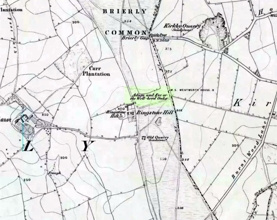
Hillfort / Settlement:  OS Grid Reference – SE 435 104

Getting Here

From the South Kirkby library, go west along Hague Lane and take the left turn up Homsley Lane on your left after  a few hundred yards (keep your eyes peeled!).  Go up here, past the housing estate, and where the trees begin on your left at the top of the Hilltop Estate, go thru them and as you emerge out the other side, the earthworks are all around you.  In fact you’re just about in  the middle of this hillfort-cum-settlement!

Archaeology & History

W.S. Banks (1871) gives an early description of this site, although he thought it to be Saxon in nature.  He told that,

“About half-a-mile east of Ringston Hill, in a field between Quarry-road and Hornsley-road, is the site of a supposed Saxon camp, as it is called on the ordnance map — a large enclosure containing above three acres of land.  It slopes to the north, and is now rough and uneven, and has been cast into ‘lands.’  The mound on the east, west and south is still very distinct.  The northern side is much lower than the other and a ditch is cut across at that part…”

And in Banks’ day, as he told, “the history of it is not known.”  But this site was later declared as a hillfort – a Brigantian one at that – for the first time by the director of Wakefield Museum, Mr F. Atkinson, following some excavation work here in 1949.  Nothing much was found apart from,

“pieces of decayed and burnt sandstone and medieval pottery sherds,” though he still concluded the site to be Iron Age. Although little of its original form can now be seen due to extensive damage, infra-red aerial photography showed “traces of a five-sided annexe to the northwest, the line of the ploughed-out rampart to the south-southwest, and a possible defended entrance to the south.”

The same aerial survey also found another enclosure to the east of the hillfort.

…to be continued…

References:

  1. Banks, W.S., Walks in Yorkshire: Wakefield and its Neighbourhood, Longmans Green & Co.: London 1871.
  2. Keighley, J.J., ‘The Prehistoric Period,’ in Faull & Moorhouse’s, West Yorkshire: An Archaeological Survey, I, WYMCC: 1981.

© Paul Bennett, The Northern Antiquarian 


Adam’s Oak, Brierley, South Yorkshire

Legendary Tree:  OS Grid Reference – SE 4280 1015

Also Known as:

  1. Adam & Eve’s Oak
  2. Wind-gap Oak

Archaeology & History

Highlighted on the 1854 Ordnance Survey map close to the township boundary line as Adam & Eve’s Oak, between Brierley and South Kirkby, I can’t find too much about this once great tree.  However the Wakefield historian W.S. Banks (1871) told us the following:

“Upon the common at Ringston Hill grows the remarkable ‘old Adam’ oak, much decreased in size in late years.  It is an ancient and large tree measuring twenty-seven feet in girth at a yard above the ground.  The trunk is hollow and the north side is broken away.  Most of the branches are also gone.  In 1868 a very large branch was blown off by the wind; but on the southerly side are still some very vigorous limbs.”

The old oak on the 1854 map

Even when Banks wrote this he said how the tree “must be many centuries old.”  In the time of King Charles II there used to be an old inn by Adam’s Oak at the foot of Ringston Hill, where the famous highwayman, Nevison (much-loved by many Yorkshire-folk because of his Robin-Hood-like character), used to stay.  The inn was owned by one Adam Hawksworth, but was ordered “to have his sign taken down for harbouring Nevison.”

Folklore

W.S. Banks also wrote of this once great tree:

“The people at Brierley tell of Nevison the highwayman lodging in it and hiding stolen treasures in it, things which probably did not happen, though Nevison’s name is connected with Ringston Hill.”

The treasure legend may have more to do with the adjacent stone circle, as we find ‘treasure’ a common motif at such places.

References:

  1. Banks, W.S., Walks in Yorkshire: Wakefield and its Neighbourhood, Longmans, Green  Co.: London 1871.

© Paul Bennett, The Northern Antiquarian 


Ringstone Hill, Brierley, South Yorkshire

Stone Circle (destroyed):  OS Grid Reference – SE 426 099

Archaeology & History

On the southern outskirts of Brierley and the northeastern edge of Grimethorpe is the curiously-named site of Ringstone Hill.  I say “curiously,” as there are no physical remnants of anything which would presently tell us of there ever being such a ring of stones here — well, nothing authentic anyway!  Some doods stuck a modern ring of stones here, but it’s pretty obviously a recent construction (apparently 1990-ish); but sometime in the not-too-distant past another circle, very probably prehistoric, could be found here…

First mentioned in 1591, the original stone circle which gave this place its name has seemingly gone; but the hill which preserves its name is a prominent place in the landscape, and this was very probably of some relevance to the builders.  On the eastern side of the hill were two large oak trees known locally as Adam & Eve, or the Well-Bred Oaks: the first name implying a creation-myth story which may have related to the ring of stones.  It also stands at the edge of the old boundary line along which, somewhere, was another tree called the Gospel Thorn, “where the gospel was read when beating the bounds.” (A.H. Smith 1961: 1:269)

This was a theme explored and developed in Mr Gomme’s (1880) old work on ancient meeting, or moot spots.  He told:

“Ringston Hill, an eminence partly natural and partly artificial, is near a point at which meet the three wapentakes (district boundaries, PB) of Strafford, Stancross and Osgodcross.  This mound appears to be connected in some manner with the early political state of this district.  It was a place of rendezvous in the time of the Civil War; for in the accounts of the township of Sheffield in 1645 occurs this entry: ‘In money, coats and the charging of a guard which went to Ringston Hill with five men that were pressed, £4, 13s, 3d.’ (Hunter’s South Yorkshire ii, 407)”

References:

  1. Gomme, G.L., Primitive Folk-Moots, Sampson Low: London 1880.
  2. Smith, A.H., The Place-Names of the West Riding of Yorkshire – volume 1, Cambridge University Press 1961.

© Paul Bennett, The Northern Antiquarian