Stone Circle (destroyed): OS Grid Reference – NY 37 50
Archaeology & History
Listed in Burl’s (2000) magnum opus, this is another long-lost megalithic ring, whose exact location seems to have been forgotten. An early description of the site by William Whellan (1860) told us that,
“There was formerly a circle of rude stones, ten yards in diameter, near the village, supposed to have been the remains of a Druidical temple; and a little distance from it, was a tumulus, three yards high and eight in diameter.”
More than a hundred years later in Waterhouse’s (1985) fine survey, he described the circle, saying:
“It lay near the village of Dalton…near the River Caldew… An 18th century account describes it as consisting of ‘rude’ stones…set in a circle of diameter about 27m. East of the the centre of the circle were four large stones lying on top of each other. They may have been the remains of a cist, or possibly a tumbled cove, like that inside the circle-henge of Arbor Low in Derbyshire. A tumulus may have stood nearby.”
There are however some discrepancies in the descriptions between Whellan and Waterhouse. In the former, the site of Chapel Flat is talked of separately as being the abode of a hermit in the lost chapel of St. Wynemius, “in a deep and romantic part of the vale of Caldew.” The description of the stone circle immediately follows this, but is spoken of as merely being “near the village.”
Does anyone know anything further about this once important site? Did the lost hermitage on Chapel Flat actually have anything to do with the stone circle?
References:
Burl, Aubrey, The Stone Circles of Britain, Ireland and Brittany, Yale University Press 2000.
Waterhouse, John, The Stone Circles of Cumbria, Phillimore: Chichester 1985.
Whellan, William, The History and Topography of the Counties of Cumberland and Westmoreland, Comprising their Ancient and Modern History, W.Whellan: Pontefract 1860.
From the little hamlet of Langbar, head up to the steep footpath to Beamsley Beacon and from there along the footpath get yourself between the giant cairn known as The Old Pike and Round Hill. About halfway between these two points the moor levels out (with brilliant views in all directions) and 200 yards southeast of the upright boundary stone, this well-defined carved rock is just a few yards north off the footpath. It seems to be just over the boundary line of Middleton Moor and onto the Beamsley Moor side (not that you give a shit when you’re up here ambling about – but the cartographers like to get things right I s’ppose!).
Archaeology & History
…and from another angleSketch of the design
Near the very top of the moor this one — this is a small carving that I rediscovered in March 2005, much of it covered in peat and heather. It’s very similar to some of the central designs found on the Baildon Moor cup-and-ring carvings, with four cup-markings (3 are deep) in a slight arc to the southern edge of this small, squared stone, very much like carvings 126 and 130 in the Boughey & Vickerman (2003) survey. However, unlike the Baildon Moor examples, no burials seem to accompany this carving—although the surrounding heather may be hiding other archaeological remains.
References:
Boughey, Keith & Vickerman, E.A., Prehistoric Rock Art of the West Riding, WYAS 2003.
We were graciously guided to this spot by local archaeological authority, Pete Glastonbury — which is good, cos otherwise it’d have probably taken us all day to find the damn thing! Best way to get here is out of the Avebury circle, east, up for about a mile up the Herepath or Green Street till you hit the ancient track of the Ridgeway. Turn left and walk up the gentle slope for another 350 yards or so, then note the footpath on your right. Go down the slope for about 150 yards, keeping your eyes peeled for the smooth rock with the slits in it, not far from the Holed Stone!
Archaeology & History
Although classified on the Wiltshire Sites & Monuments Record as an “unclassified feature,” this is one of a number of whetstones (as we call ’em up North) that feature in various settings in and around the Avebury region: literally, a rock used for sharpening axes, daggers and other metallic artifacts. First rediscovered in the spring of 1963 by a Mr Inigo Jones when he was out exploring the many rocks hereby for rare lichens and any more cup-markings like the one at nearby Fyfield Down, the site we see today is merely a long piece of stone with five or six long lines or grooves cut into the top-end, along which the ancient weapons and tools slid and cut into the rock, sharpening them.
It was thought until recently that this was the prime function of this stone; but following excavation work done here by Pete Fowler and his team in 1963, it seems that the stone actually stood upright! Digs were made on three sides of the stone and some earlier disturbance seemed apparent:
“The material appeared to be redeposited on top of an earlier ground surface, inferentially of medieval or earlier date. At the north end of the sarsen bench, the lip of a pit or trench was partly excavated. It showed clearly in plan as a feature dug into the top of an undated surface level with the disturbed top of the clay-with-flints; it was filled with flinty, clayey humus similar to that through which it was cut. In the top of that fill was a heavily weathered sarsen, c 0.6m by 0.45m, and a cluster of smaller, broken sarsen stones. The hole was at least 0.45m deep, its bottom as excavated marked by an increase in the density of flints. The evidence, though incomplete, suggested very strongly that the feature was part of a hole dug to take the pollisoir as an upright stone.” (my italics, Ed)
In the same dig, a medieval coin of King John (1199-1216) and the remains of a medieval horseshoe were found beneath the stone, giving Fowler and his team the notion that the stone had been split and pushed over at this period. Consistent evidence of activity from the neolithic period onwards was expected and found here.
In Lacaille’s (1963) original description of the site, he gave a most accurate description of the dimensions of the stone and its incisions. Highlighting its proximity to a cluster of other stones, as well as being close to a wide ditch, Lacaille’s measurements were thus:
“From 1ft (0.31m) above ground at its south end the regular surface of the sarsen slopes to the grass, its main axis being aligned about 15° west of the true north and south line. In length the stone measures 5ft 6in (1.68m) above the grass, and 2ft 10in (0.86m) in width.
“Closely grouped in the south-eastern corner of the sarsen there are six hollows. In plan the largest and southernmost is of long elliptical shape, 1ft 8in (0.5m) long and 9in (0.23m) at widest and 1in (0.0254m) deep. From its wider end near the eastern long margin there protrudes a short groove. Beside this, and curving slightly inward, there is another groove, 1¼in (0.028m) wide and ½in (0.013m) deep. It is as long as the large basin-like cavity. Next to it there runs one of similar length and width, but of only half the depth. In turn, a third groove, ½in (0.013m) wide, 1ft 8in (0.5m) long, has been worn at right angles to the long edge but to a much deeper hollow than its companions. At 2in (o.051m) to the north a lesser version of the main basin occurs. Like this it measures 1ft 8in (0.5m) in length, but is only 2¼in (0.058m) wide and ¾in (0.016m) deep. Vague in places over its interior length of 10in (0.25m), but attaining a maximum width of 1¼in (0.028m), a last hollowing shows faintly at both ends and nowhere deeper than 1/8in (0.0032m).”
The Polisher & its marksCeloria & Lacaille’s 1963 drawing of the stone
It appears that this fallen standing stone was being used to sharpen knives and axes whilst it stood upright and, in all probability, as a result of this ability would have been possessed of magickal properties to our ancestors. Metalwork was an important province of shamanism and smiths, whose practices were deeply enmeshed in the very creation of mythical cosmologies. Hence, the simple act nowadays of sharpening metal tools onto rocks would not have been a mere profanity to the people who came and used this stone to re-empower their weapons, but would have been entwined within a magickal cosmology. The spirit inherent in this stone would likely have been named and recognised. Today it is forgotten…
It also seems that this standing stone was part of some ancient walling. Aerial views clearly show it along the line of some sort of enclosure that runs down the slope, along the bottom and back up and around. In the same stretch of this enclosure walling we find the Holed Stone a little further down the slope. And holed stones, as any student of folklore and occult history will tell you, have long-established magickal properties of their own…
References:
Fowler, Peter, Landscape Plotted and Pierced: Landscape History and Local Archaeology in Fyfield and Overton, Wiltshire, Society of Antiquaries: London 2000.
Grigson, Geoffrey, The Shell Country Alphabet, Michael Joseph: London 1966.
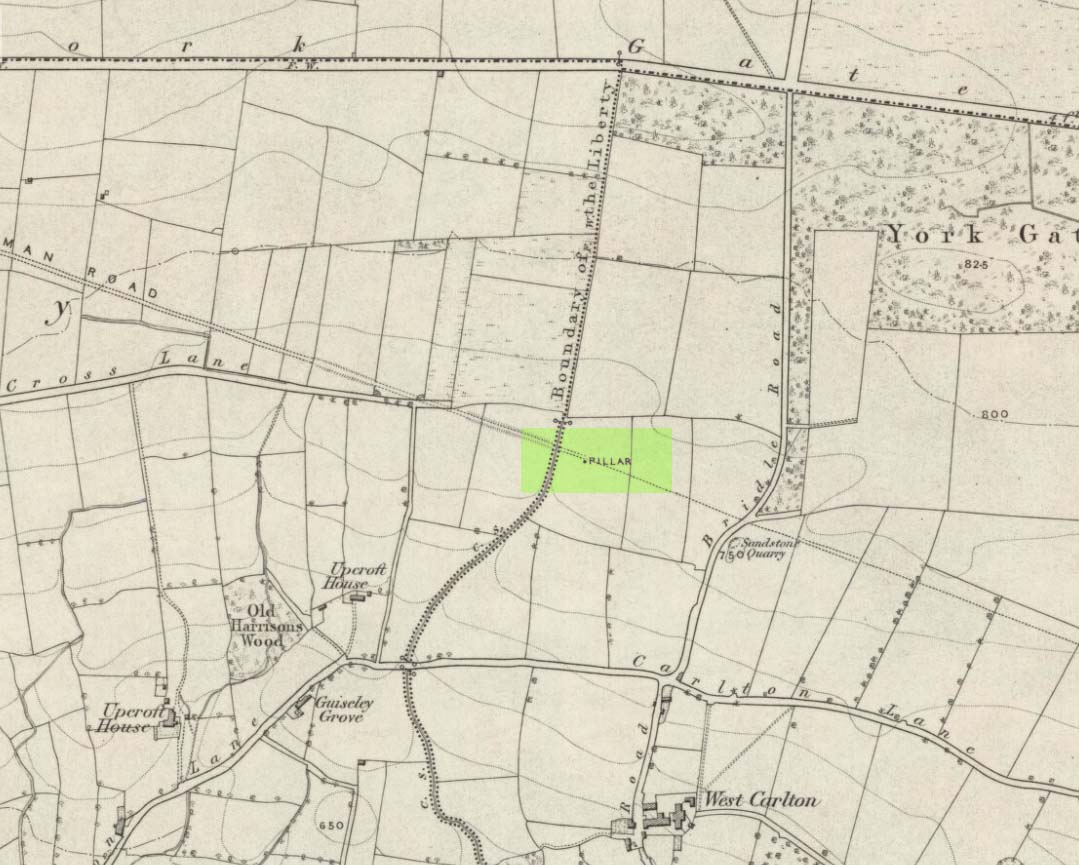
Worth checking this if you aint seen it before! Head up to the back (south-side) of Otley Chevin (where the cup-and-ring Knotties Stone lies sleeping), following the road there and park up near/at the Royalty pub. Take the footpath behind the pub which crosses the fields and once into the second field, head diagonally down to the far-left corner. From here, look over the wall — you can’t really miss it!
Archaeology & History
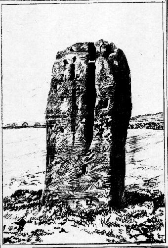
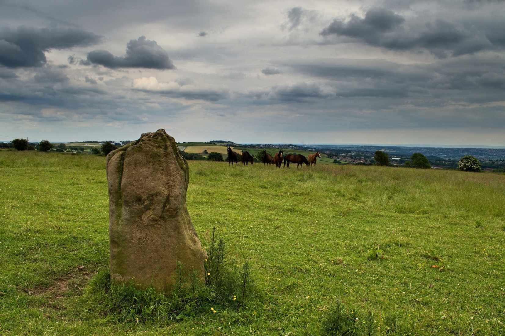
An intriguing site for various reasons. All we have left to see of any value nowadays is this nigh-on 6-foot tall thick monolith, standing alone in the field halfway between West Carlton and Otley Chevin. Completely missed in local archaeological surveys, the place was mentioned briefly by Slater (1880); though it appears to have been first described in detail by Eric Cowling (1946), who suspected the stone may have Roman origins (though didn’t seem too convinced!), saying that:
“near the ground the section is almost oblong, with sides three-feet six-inches by one-foot ten-inches; two feet from top, the section is almost circular.”
The fact that the stone stands very close to the line of an all-but forgotten Roman road that runs right past it added weight to this thought (the road runs towards a Roman settlement a mile east of here near Yeadon). But this standing stone is unlikely to be Roman. More recent evidence seems to indicate a relationship with a now-lost giant cairn about 100 yards to the south. The only remains we have of this place are scatterings of many small loose stones nearby. And it seems a very distinct possibility that the extra standing stones that were once hereby, stood in a line.
The very first reference I’ve found about this site also indicates that there was more than one stone here in the past! In 1720 this site was known as the ‘Boon Stones’; and the plural was still being used by the time the 1840 Tithe Awards called them the ‘Boul Stones.’ Initially it was thought that both words were plural for “bulls” — as A.H. Smith (1962) propounds in his otherwise superb survey — but this is questionable. (see Folklore)
Folklore
A piece of folklore that seems to have been described first by Philemon Slater (1880) relates to the pastime of bull-baiting here, that is –
“fastening bulls to it when they were baited by dogs, a custom…still known to the Carlton farmers” (North Yorkshire).
Cowling (1946) told that he heard the stone was said to be lucky as well as being a source of fertility. This ‘fertility’ motif may relate to the meaning of the stone’s early name, the Boon Stones. Both boon and boul are all-but obsolete northern dialect words. ‘Boul’ is interesting in its association with a prominent folklore character, as it was used as a contemptuous term “for an old man.” Now whether we can relate this boul to the notion of the ‘Old Man’ in British folklore, i.e., the devil, or satan — as with the lost standing stone of The Old Man of Snowden, north of Otley — is difficult to say.
More interestingly perhaps is the word ‘boon’, as it is an old dialect word for “a band of reapers, shearers, or turf-cutters.” This band of reapers ordinarily consisted of five or six people and would collect the harvest at old harvest times. And as the early description talks of Boon Stones, this plurality would make sense. One curious, though not unsurprising folklore relic relating to these boons was described at another megalithic site (now gone) by John Brand (1908), where in the parish of Mousewald in Dumfries,
“The inhabitants can now laugh at the superstition and credulity of their ancestors, who, it is said, could swallow down the absurd nonsense of ‘a boon of shearers,’ i.e., reapers being turned into large grey stones on account of their kemping, i.e., striving.”
Standing stones with the folklore of them being men or women turned to stone is common all over the world. If we accept the dialect word ‘boon’ as the first name of this old stone, there may once have been some harvest-time events occurred here long ago (and this is quite likely). Equally however, we must also take on the possibility that this Bull Stone has always been a loner and that its name came from the now obsolete Yorkshire word, a bull-steann, meaning a stone used for sharpening tools, or a whetstone.
Take your pick!
References:
Bennett, Paul, The Old Stones of Elmet, Capall Bann: Milverton 2001.
Brand, John, Observations on the Popular Antiquities of Great Britain – volume 2, George Bell: London 1908.
Cowling, Eric T., Rombald’s Way, William Walker: Otley 1946.
Jackson, Sidney, ‘The Bull Stone,’ in Cartwright Hall Archaeology Group Bulletin, 2:5, 1956.
Smith, A.H., English Place-Name Elements – 2 volumes, Cambridge University Press 1956.
Smith, A.H., The Place-Names of the West Riding of Yorkshire – volume 7, Cambridge University Press 1962.
Slater, Philemon, The History of the Ancient Parish of Guiseley, William Walker: Otley 1880.
Go up through Baildon centre and head onto the moors. Crossing the cattle-grid, a coupla hundred yards further up, turn left. Past the small reservoirs on your left, another 100 yards or so and you reach the brow of the hill. As you begin going down the road, there’s a small car-park right by the roadside. The curious remains of the earthworks at the side of the old circle are discernible in the grassland right to its side.
Archaeology & History
Illustrated on the 6-inch OS-map of 1852 as “Site of a Barrow” (similar to how it appears in the image drawn here by Mr. C.N.M. Colls) a short distance below Pennythorn Hill top, there are still considerable traces of the earthworks surrounding the east and southern sides of what was once some form of ring cairn or tumulus that was once at this prominent place in the landscape.
Aerial view of siteThe site was first explored by Mr Colls in 1843 (his results were reported a few years later), who found a loose double-ring of stones, fifty feet across, surrounded by a shallow trench which was most notable on the south and east sides. Two urns were also uncovered near the centre of the ring, nearly two feet down, containing the cremated remains of people. A few years later, the Leeds historian James Wardell (1869) told a most fascinating note about what happened during their excavation, saying:
“This…examination was attended by a circumstance not soon to be forgotten by the persons engaged therein (on the excavation). They had almost reached the place where the broken urn and bones were deposited when, at once, such a fearful storm of thunder, lightning and rain came on, that they were not only considerably alarmed, but driven from the Common to seek shelter in the village.”
Colls’ 1846 sketch
We hear this sorta thing at many of our ancient places!
Colls 1846 plan
One anonymous writer in 1955 described the site as a ‘stone circle’, and a number of subsequent archaeologists copied this without question; but in all probability this site was more typical of an old cairn circle or ring-cairn, similar in size and design to the Roms Law circle two miles north of here. However, the earthworks at its side give the impression of some sort of exaggerated hengiform enclosure.
The place-name element howe strongly indicates a burial site and is a suffix found at many prehistoric tombs across northern England. The prefix ‘acre’ may relate to “a plot of arable or cultivated land, a measure of land (an acre) which a yoke of oxen could plough in a day” (Smith 1956), or may be a corrupted form of the Old English word, ‘acen’, relating to oak trees. Early literary examples of the place-name would enable a clearer understanding of the prefix element here.
References:
Anonymous, Colls’ Burial Mound Stone Circle, Baildon Moor, Museum Leaflets: Bradford 1955.
Baildon, W. Paley, Baildon and the Baildons (parts 1-15), St. Catherines: Adelphi 1913-26.
Barnes, Bernard, Man and the Changing Landscape, Eaton: Merseyside 1982.
Bennett, Paul, The Old Stones of Elmet, Capall Bann: Milverton 2001.
Colls, J.N.M., ‘Letter upon some Early Remains Discovered in Yorkshire,’ in Archaeologia, 31, 1846.
Collyer, Robert & Turner, J.H., Ilkley: Ancient and Modern, William Walker: Otley 1885.
Smith, A.H., English Place-Name Elements – volume 1, Cambridge University Press 1956.
Wardell, James, Historical Notes of Ilkley, Rombald’s Moor, Baildon Common, and other Matters of the British and Roman Periods, Joseph Dodgson: Leeds 1869. (2nd edition 1881)
This is a lovely-looking stone in the pictures and diagrams, and is quite easy to find close to the meeting of the footpaths along Foldshaw Ridge and the Parks Lane track, near the gate. It lays at an angle in the short grass just by the path…but to me, all is not what it seems…
Archaeology & History
This was a carving I saw pictures of in the 1970s, and always thought it would be something to behold – but my first impression here wasn’t just disappointment, but the most distinct thought that the carving’s modern! It’s a real oddity. For a start, the cups in this carving are very small – much smaller than the countless authentic carvings on the moors here and at Ilkley to the south. And after seeing thousands of these things, this one didn’t seem at all right.
The lack of erosion on the cups may be due to it once accompanying a prehistoric tomb some time in the past, though no such remains have been noted here. However, at carved stones Middleton Moor 001 and Middleton Moor 2 — less than 100 yards to the east — cairns are in evidence next to the petroglyphs, indicating that this relationship occurs at some cup-and-ring stones in this small geographical region and, perhaps, explaining the ideosyncratic nature of this design.
But such speculation aside – the brief literary history of this stone is: first described by Stuart Feather in 1965 and illustrated by Sidney Jackson the same year. The rock art students Boughey & Vickerman’s (2003) described around sixty ‘cups’ etched onto the stone here, but they made no comment about either the odd nature of the cups or the possibility of it being modern. Perhaps it’s just me…
References:
Boughey, Keith & Vickerman, E.A., Prehistoric Rock Art of the West Riding, West Yorkshire Archaeology Service 2003.
From Killin, take the Glen Lochay Road past the Moirlanich Longhouse, but keep on for another mile, and take the track on the left up to Murlaganmore cottages. As the track turns right of the tree-line, cross the field (left) up towards the open gate as if you’re going to the Murlaganmore 2 carving, where you’ll see this large flattish rock in the grasses about 100 yards before it.
Archaeology & History
When we visited this old boulder last week, we had the misfortune of grey days and dark clouds throwing their faded light across this cup-marked rock, not really letting us see with any clarity the many cups which pepper (mainly) the edges of the rock. But the cups are faded anyway, so accounts tell, and the 15 which we counted were same 15 recorded about 100 years ago in C.G. Cash’s (1912) survey. There, he described this old stone as,
“about 200 yards south of the house, in the middle of the uppermost pasture. It is a large block of quartz schist stuck thick with garnets, and bearing fifteen cup-marks, only one of which — 3 inch in diameter and 1 inch deep — is really well defined, and several of which are faint.”
Faint cups barely visibleC.G. Cash’s early drawing
But despite the grey day (She was absolutely teeming with rain half of the time!), I found the setting here absolutely gorgeous, with the many shades of old trees and the clear blood of pure waters falling through the landscape. And, without doubt, there are other carved stones nearby that have yet to capture the attention of surveyors. You can smell them!
References:
Cash, C.G., ‘Archaeological Gleanings from Killin,’ in PSAS 46, 1911-12.
Royal Commission on Ancient & Historical Monuments, Scotland, The Archaeological Sites and Monuments of Stirling District, RCAHMS: Edinburgh 1979.
Cup-Marked Stone: OS Grid Reference – SE 0791 4422
Archaeology & History
Ant Stone, uncovered
Discovered today, amidst a cluster of other carvings not previously catalogued. This was hidden beneath a mass of vegetation, but after cutting and digging into the peat on top of the stone, several cup-marks became evident. By the side of the rock, measuring roughly 8 feet by 5 feet, was a small ant’s nest — hence the convenient name of the carving.
Central design of the carving
The main feature is the large, perhaps natural cup-mark, about 3 inches across. But three distinct artificial cup-markings were etched around the edges of this larger ‘cup’. When we found this stone, the daylight was nearing its end and we were unable to ascertain any further features carved onto the rock. Several other carvings were close by, none of which were included in the survey by Boughey and Vickerman. (2003) After we’d finished here, we covered the stone back over with its peaty quilt and hoped that the ants weren’t too pissed off about us disturbing them…
From East Morton village, take the moorland road, east, and up the steep hill. Where the road levels out there’s a right turn, plus (more importantly!) a trackway on your left which leads onto the moor. Go up this traclk and keep walking till you hit a moorland ‘footpath’ signpost. Stop here and walk due west (your left) onto the gently sloping rise of Stanbury Hill. Keep walking for a 250 yards or so, where the land has sloped gently down to the end of the spur; and just 50 yards before it drops down tot he stream below you’ll find a cluster of rocks scattered about. One of the stones here is this one!
Archaeology & History
This is an excellent carving first recorded, it seems, by Stuart Feather in 1977, as cited in the Yorkshire Archaeology Journal’s ‘Listings’ for 1978. It can be found some 27 yards west of a prehistoric cairn near the top of the ridge (14 yards east of the same cairn is the Spotted Stone carving).
Lunar Stone carvingSoutheast section, with 3 cup-and-rings?
We have to assume that when Mr Feather first located this stone that the faint cup-and-rings on the topmost southeast section of the rock had been exposed to the elements from Day 1, so to speak: as the designs here are quite faint and well-worn. Another not unreasonable assumption is that Mr Feather then proceeded to dig away at the rest of the rock, exposing other features on the stone which had laid under the soil for countless centuries, as the northernmost part of the carving has minimal erosion effects on it. Indeed, unless this is true, we have to start thinking that the carving was made over quite lengthy periods of time, due solely to the greater and lesser effects of weathering on different sections of the stone.
As seen in both the diagram and photos, this is a quite extravagent design. Consisting of several cup-and-rings, aswell as a double-ring, it is found amidst a small cluster of equally impressive, albeit very different carved rocks, all appearing to have a quite specific relationship with death and ritual. This and the other stones are found on the western end of a small serpentine ridge of land (Stanbury Hill), with streams flowing on the north and western sides and small remains of marshland to the south. The geomantic feature here, if relevant, relates to movements between the Earth, water, death and the setting sun: quite potent and important issues in the lives of the neolithic and Bronze Age peoples who lived hereby.
Northern section of carving – with calendrical cups?
The title of this stone carving — the Lunar Stone — should be quite evident: the design has all the hallmarks of celestial lunar movements around the ridge of the heavens; or here, pictured along the edges of the rock (symbolic of the firmament), upon and amidst which the moon travels in its rhythmic motion through the heavens. But don’t take that too seriously: it’s just an imaginative flutter that struck my otherwise distraught inability to know what I’m talking about!
References:
Hedges, John (ed.), The Carved Rocks of Rombald’s Moor, WYMCC: Wakefield 1986.
Head up to the Cow & Calf Rocks and walk to the large disused quarry round the back (west). You’ll notice a scattered copse of old pine trees on the edge where the hill slope drops back down towards Ilkley; and there, two raised hillocks (unquarried bits) rise up where the pine trees grow. The carvings are on the flat rocks atop of one of the two hillocks. If you’re walking up from Ilkley, once you’ve crossed the cattle-grid in the road and the moorland slope opens up above you, just walk uphill towards the copse of trees and watch out for the rock outcrop in the picture here.
Archaeology & History
Very well-known to locals, folklorists and archaeologists alike, the remains of these old glyphs have caught the attention of artists, historians and Forteans alike for the images and tales surrounding them. It was obvious that in times past, that the carved remains that we see today would have extended considerably further, but the quarrying destroyed much of it. Indeed, we’re lucky to have this small section of carved rock still intact!
The rocks were first described as the Hanging Stones in the local parish records of 1645, and their name probably derives from the old-english word hangra, meaning ‘a wood on a steep hill-side,’ which is very apt here. The first known description of the site as possessing cup-and-rings appears to have been in a small article in the local Leeds Mercury newspaper in 1871. Several years later J. Romilly Allen (1879) wrote a lengthier descripton of the site:
“The crags from which these masses have been detached are known by the name of hanging stones, and at their eastern extremity is a large quarry. Between this quarry and the overhanging edge of the cliff a portion of the horizontal surface of the rock was some years ago bared of turf, thereby disclosing the group of cup and ring sculptures shown on the accompanying drawing. It will be seen that the design consists of twenty-five cups of various sizes, from 1 to 3 inches in diameter. Seven of the cups are surrounded by incomplete rings, many of them being connected by an irregular arrangement of grooves. The pattern and execution are of such a rude nature as almost to suggest the idea of the whole having been left in an unfinished state. The sides of the grooves are not by any means smooth, and would seem to have been produced by a process of vertical punching, rather than by means of a tool held sideways.”
Allen and other archaeologists from this period saw some considerable relevance in the position of this and the many other cup-and-rings along this geological ridge, telling:
“The views obtained from all points over Wharfedale are exceedingly grand, and this fact should not be lost sight of in studying remains that may have been connected with religious observances, of which Nature worship formed a part.”
J. Romilly Allen’s 1879 drawing of the carvingsWater-assisted double-ring on eastern rock
A common sense point that seemed long-lost to many archaeologists, adrift as they went in their measurements of lithics and samples of data charts for quite a number of years. In recent years however, this animistic simplicity has awakened again and they’ve brought this attribute back into their vogue. Let’s hope they don’t lose sight of it again!
There are tons of other archaeological references to this fine set of carvings, but none add anything significant to anyone’s understanding of the nature of the designs. We must turn to psychoanthropology, comparative religion and folklore if we want to even begin making any realistic ‘sense’ (if that’s the right word!) of this and other cup-and-rings. Curiously, the nature of this and other carvings is a remit archaeology has yet to correctly engage itself in.
Hanging Stones with “21st century informal unauthorised carvings”
On a very worrying note, we need to draw attention to what amounts to the local Ilkley Parish Council officially sanctioning vandalism on the Hanging Stones, other prehistoric carvings and uncarved rocks across Ilkley Moor. As we can see on a couple of photos here, recent vandalism has been enacted on this supposedly protected monument. Certain ‘officials’ occasionally get their headlines in the local Press acting as if they’re concerned about the welfare of the ancient monuments up here, but in all honesty, some of them really don’t give a damn. The recent vandalism on this stone and others has now been officially recognised as an acceptable “tradition” and a form of — get this! — “twentieth / twenty-first century informal unauthorised carving” and has been deemed acceptable by Ilkley Parish Council as a means to validate more unwanted carving on the moorland “in the name of art”! Of course, their way of looking at this has been worth quite a lot of money to a small group of already wealthy people. But with Tom Lonsdale and Ilkley Council validating or redesignated ‘vandalism’ as “twenty-first century informal unauthorised carvings”, this legitimizes and encourages others to follow in their shallow-minded ignorant footpath, enabling others with little more than a pretentious ‘care’ for both environment and monuments to add their own form of ‘art’ on cup-and-ring carvings, or other rocks on the moors.
Hanging Stones with more “21st century informal unauthorised carvings”
You can see in some recent vandalism — sorry, traditional “twentieth / twenty-first century informal unauthorised carving” — at the top-right of the Hanging Stones photo to the side, a very ornate ‘Celtic’-style addition, akin to the quality carved by well-known stone-mason Pip Hall who, coincidentally, has now been granted a lot of money to “officially” carve her own work on another stone further down the valley from here. With Miss Hall, Mr Lonsdale, poet Simon Armitage and Ilkley Parish Council each playing their individual part in encouraging what is ostensibly vandalism…errr…sorry – I keep getting it wrong – I mean traditional “twentieth / twenty-first century informal unauthorised carving” on the Hanging Stones monument and other cup-and-ring stones on the moor, we can perhaps expect a growth industry in this field…..especially if you’re wanting to make more money for yourself in the name of art or poetry. And if you apply to Rachel Feldberg of the Ilkley Arts Festival, you may get good money for your work… Seriously! (this is no joke either)
Please contact Ilkley Parish Council and other relevant authorities and express your dismay at their lack of insight and concern for the knock-on effects of their decisions on this matter. Other plans to infringe even further onto Ilkley Moor are in the business pipeline…
Folklore
Just underneath the carved overhanging rocks (walk off the knoll to the bottom of the rocks, facing the town), is a small recess or sheltered cavity which, told Harry Speight (1900),has
“From time immemorial (been) known as ‘Fairies’ Kirk’, and traditions of it having been tenanted by those tiny sprites, the fairies, still exist among old people in the neighbourhood.”
Tradition goes on to tell that when the Saxons arrived here, they were wont to build a christian church by the Hanging Stones, but the little people strongly resented this and fought hard against the invading forces. As the Saxons started building the edifice of the new religion, during the night the fairy folk took down the stones and moved them into the valley below. In the morning when the Saxons found this had happened, they carried the stones back up to begin building again; but each night, the fairy folk emerged and again took the stones to the valley bottom again. Eventually, after much hardship, the Saxon folk gave up the idea of building on the Fairie’s Kirk, as it was known, and the church that still remains in Ilkley centre was decided as an easier place to build their edifice.
Traditions such as this (of fairies moving stones back to whence they came, or away from ancient archaeological sites) are found throughout Britain and appear to be simple representations of the indigenous peasant hill-folk who strongly objected to their own sacred sites (rocks, trees, wells, etc) being supplanted by the invading religious force.
In more recent years the observation of curious light phenomena over these rocks have been seen, both over here and the Cow & Calf Rocks…
References:
Allen, J.R., ‘The Prehistoric Rock Sculptures of Ilkley,’ in Journal of the British Archaeological Association, vol.35, 1879.
Bennett, Paul, The Old Stones of Elmet, Capall Bann: Milveton 2001.
Bogg, Edmund, Higher Wharfeland, James Miles: Leeds 1904.
Collyer, Robert & Turner, J. Horsfall, Ilkley: Ancient and Modern, William Walker: Otley 1885.
Gelling, Margaret, Place-Names in the Landscape, Phoenix: London 2000.
Hedges, John (ed.), The Carved Rocks of Rombald’s Moor, WYMCC: Wakefield 1986.
Leeds Mercury, ‘Prehistoric Remains at Ilkley’, 20 April, 1871.
Michell, John, The Earth Spirit: Its Ways, Shrines and Mysteries, Thames & Hudson: London 1975.
Size Nicholas, The Haunted Moor, William Walker: Otley 1934.
Smith, A.H., English Place-Name Elements – volume 1, Cambridge University Press 1956.
Speight, Harry, Upper Wharfedale, Elliott Stock: London 1900.


")
")


