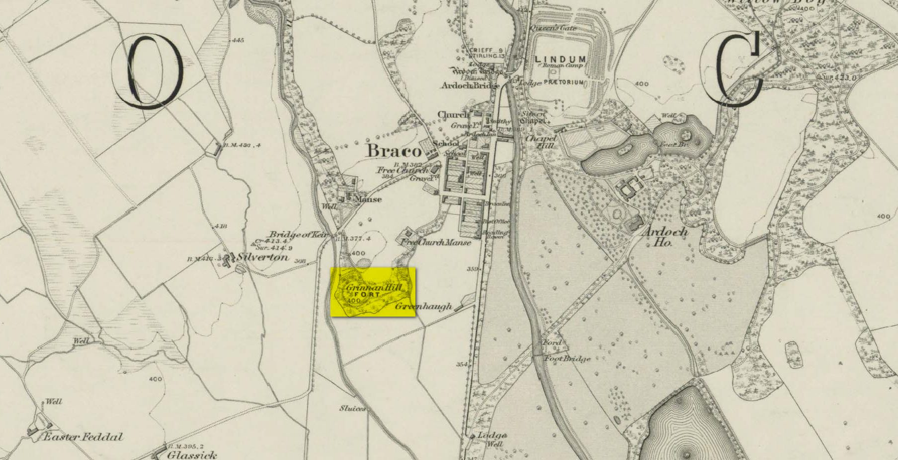
If you’re coming by car, Braco’s an easy place to park. Once here, walk up the main road, past the terrace houses until, on your left, you reach the B8033 Feddal Road. About 500 yards on, where the houses end and you reach the small river bridge, you’ll notice a footpath immediately on your left with a small table where you can have a cuppa. Walk past this, into the trees and along the riverside for barely 100 yards, and walk up the hillside on your left. On your way up are a couple of large humps, a bit like a small roller-coaster. You’re here!
Archaeology & History
Antiquarians amongst you are gonna love this. It’s huge! Hiding away and all but forgotten in the little village of Braco, overgrown with trees and brambles, this steep wooded defensive structure has a series of large ramparts—three in all—that you’ll walk up and down before hitting a slightly undulating summit.
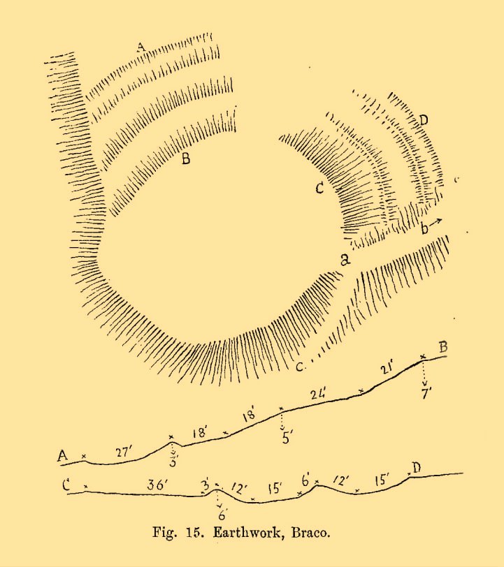
William Roy’s 1793 planChristison’s 1900 plan
The site was shown as an unnamed triple-ringed hill on William Roy’s 1747-52 survey of Scotland, with the lines representing the ramparts of this ‘fortress’. Some years later, Roy (1793) briefly mentioned the site when he was comparing indigenous fortifications with those of the Roman invaders, saying that “the small camp at Ardoch” probably “contained more than a Roman legion, with their auxiliaries.” His sketch and layout of the hillfort (right) is interesting in that it shows the more compete fortified ramparts on the north-eastern sides, which have today been covered by the modern houses. The ramparts in this part of the hillfort were still visible when the brilliant Miss Christian MacLagan (1875) came here; and in a subsequent visit by Mr Christison (1900) they could still be seen, as we can see in in his sketch (left). When we visited recently, it looked as if the lads who’d landscaped the large gardens most probably, unknowingly, used the soil of the ramparts to create them!
Apart from the missing northeastern ramparts, the site today is little different from when our antiquarians wrote of it more than a hundred years back. Read Miss MacLagan for example, who said:
“Near the parish church is an eminence called Grianan Hill, on which are still to be traced the remains of a British fort. The hill is a beautifully wooded knoll to the west of the village of Braco. It appears to be about 100 feet in height above the level of the surrounding land; on three of its sides the ground is perfectly flat, and we could suppose that in the amply days of the fort above, it had been environed on three sides by a lake, which would of course contribute to its strength. The fourth side of the hill, having but little natural strength, has been strongly fortified by three great walls. This is the side which connects the knoll with the neighbouring rising ground which is nearly as high as itself.
“The area enclosed by the innermost circular wall has a diameter of 130 feet. The space between this wall and the second is 37 feet, and the space between the second and third walls 47 feet. Almost every stone of this fort has been removed, but the lines and trenches which mark their former presence are still very distinct.”
Christison (1900) subsequently gave us much the same, with just some additional points here and there:
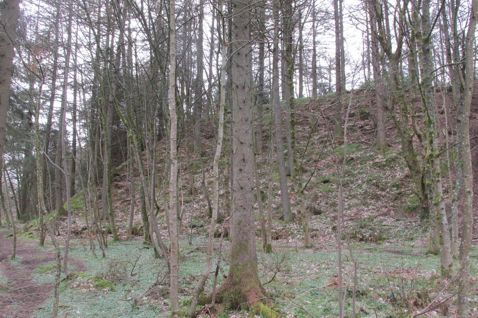
Looking up at SW sideLooking up at S side
“The site is less than ½-mile SW of Ardoch camp, 420 ft above the sea, on the edge of a steep descent, 40 to 50 ft high, to Keir Burn, but only slightly elevated above the field towards Braco village. It has apparently been an earthwork with a semi-oval triple line of defence…partly ramparted and trenched, partly terraced, the broad oval being rudely completed by the unfortified edge of the steep bank. The entrance, a, is along the narrow crest of a ridge, i, from the E, and it is likewise approached by a rude roadway, c, from the burnside below. Roy’s plan makes the work nearly complete, but the middle half of the lines no longer exists. He says that it may have been a work of the natives before the arrival of the Romans, but calls it a (Roman?) ‘post.’ There can be no doubt that it belongs to a common type of native fortresses. Its extreme length is about 320 ft, and the interior may have been about 200 by 170.”
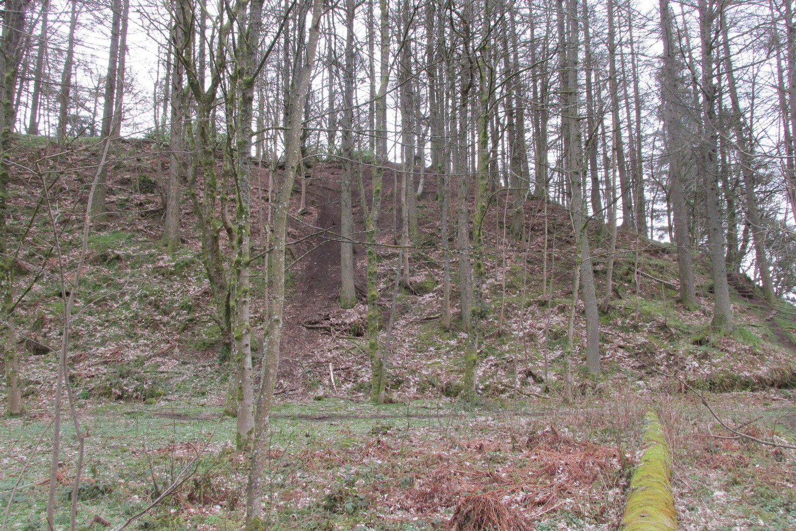
Southern line of wallingFootpath along rampart
What he failed to point out—and contrary to Canmore’s comment that “the interior is featureless”—is the length of internal walling running nearly halfway through the top of the hillfort, cutting it in half so to speak, roughly southeast to northwest: the eastern area slightly larger than the west, which is a little higher. A ‘gate’ or passage between these two sides seems apparent halfway along this line of walling. This wall, like the long one running along its southern edge, is a couple of feet high and more than a yard across. In the western section a small pit has been dug, about eight feet across and a yard or so deep. Local lore tells that this was an old Roman fire-pit!
Around the very bottom mainly on the west-side of the hill, remains of old walling can be seen for a couple of hundred feet beneath the vegetation, but I’m unsure about the date of this structure. It may well be a 19th century construction, but without an excavation—and none has ever been done here—we will never know for sure.
Undulating ramparts
One final thought on this place is how is may have related with the large Roman forts that are just a few hundred yards away to the northeast. When the invaders came here, local tribal folk no doubt watched them with caution. One wonders whether or not some sort of ‘agreement’ was made between our local folk and the aggressive incomers, with them coming to some sort of nervous truce between them which allowed the Romans to build their camp to the east, as long as they kept their distance from the folk in this hillfort. Just a thought…..
References:
Christison, D., “The Forts, Camps and other Field-Works of Perth, Forfar and Kincardine,” in Proceedings Society Antiquaries, Scotland, volume 34, 1900.
Hogg, A.H.A., British Hill-Forts: An Index, BAR: Oxford 1979.
MacLagan, Christian, The Hill Forts, Stone Circles and other Structural Remains of Ancient Scotland, Edmonston & Douglas: Edinburgh 1875.
Roy, William, Military Antiquities of the Romans in North Britain, W. Bulmer: London 1793.
Acknowledgements: Huge thanks for use of the 1st edition OS-map in this site profile, Reproduced with the kind permission of the National Library of Scotland.
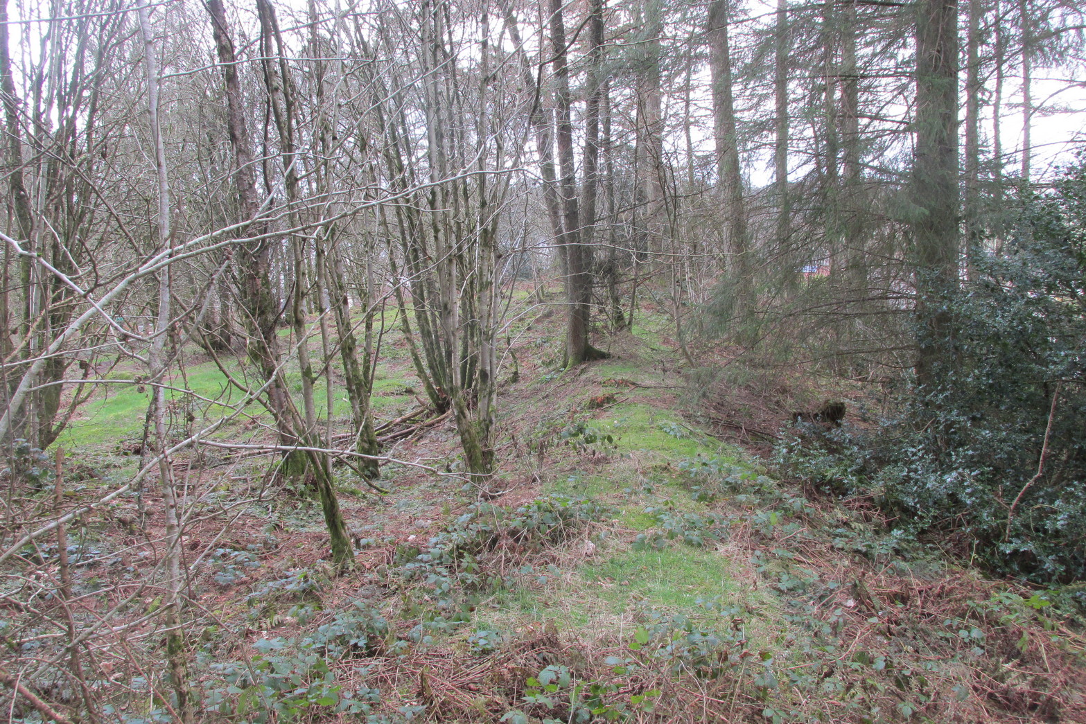
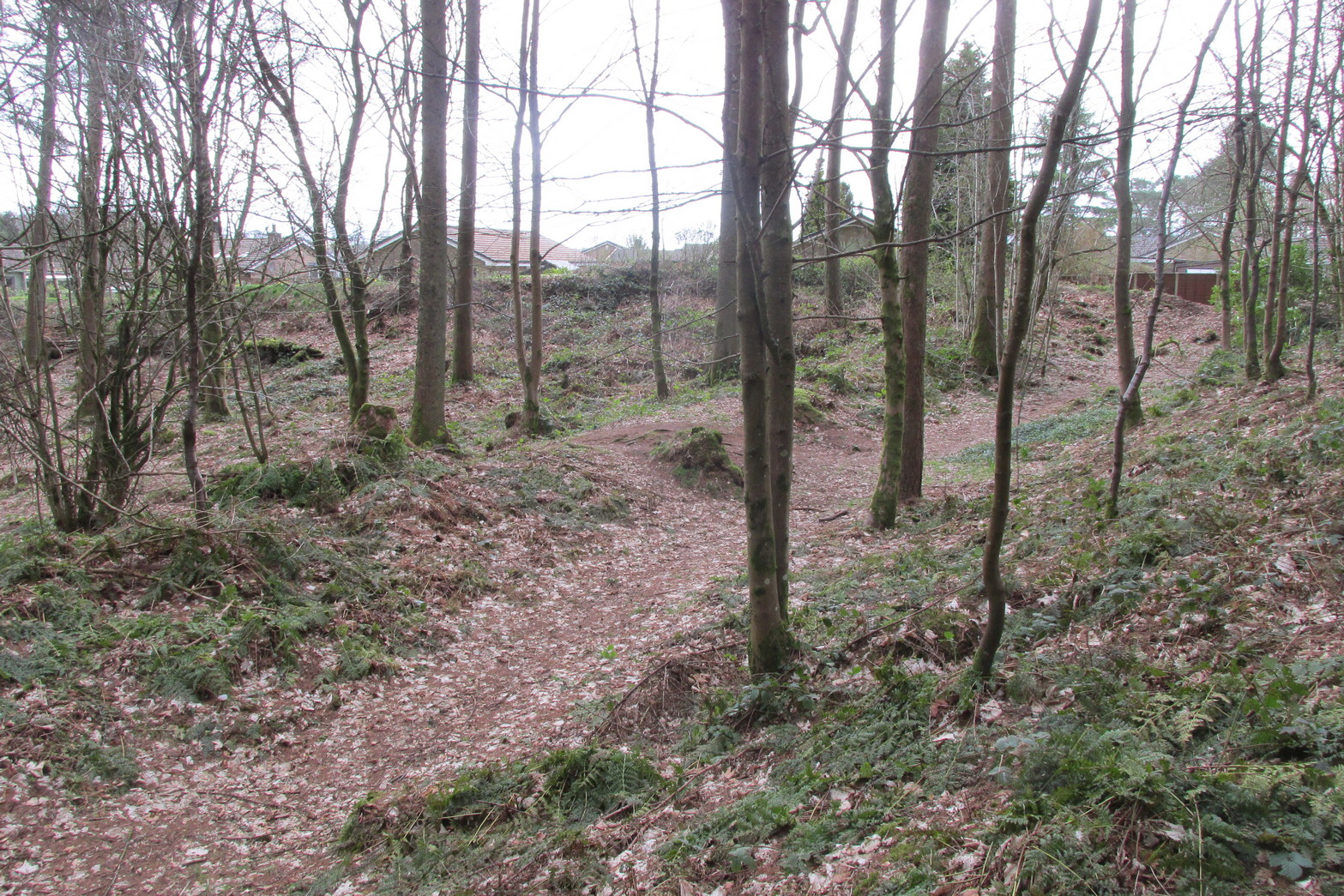
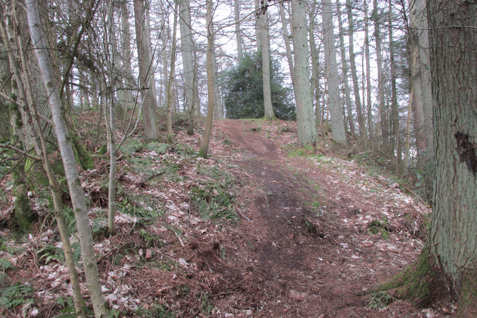
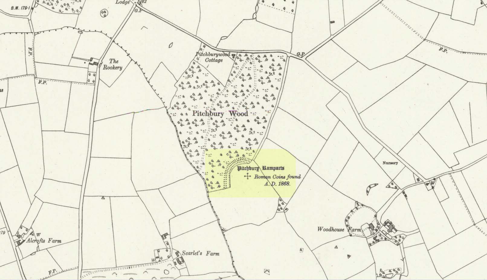
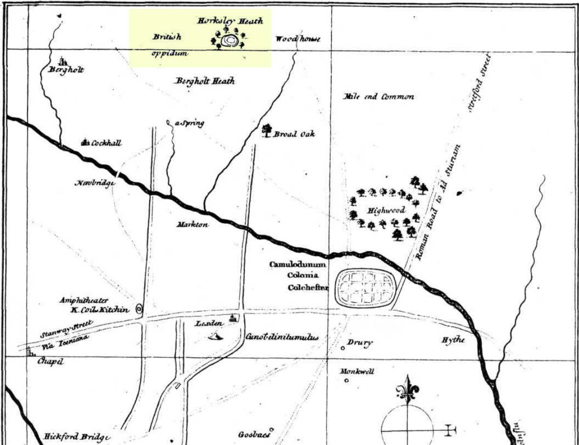
Along the A134 in Horkesley Heath, turn west along Coach Road and after a half-mile where it veers right, keep going for another half-mile where you’ll reach the woodland on your left. A path goes into the trees just before Pitchbury Lodge. Go along here and near the very far (southern) end of the trees, just before the open fields, you’ll see the large undulating ramparts of earth. Keep your eyes peeled. You’ll see them!
Archaeology & History
Stukeley’s 1759 map
This once large hillfort was described in the Colchester township perambulations of 1671 and cited in Philip Morant’s classic work. (1748) He told how the boundary line ran “under Chesterwell along the Rampiers by Horkesley Heath,” and which P.H. Reaney (1935) tells was our wooded hillfort. In Morant’s day, the place was all but complete and so would have been well recognised by local people. Certainly it came the attention of the great antiquarian William Stukeley who, in 1759, came to Colchester and met with Morant. Stukeley mainly surveyed the area south of here, at Lexden Heath, but one of his sketch maps clearly highlighted a place he called “a circular work on Horkesley Heath”, i.e., Pitchbury Rings. The site seems to have remained relatively intact until the middle of the 19th century when a local land-owner took it upon himself to plough over and vandalise much of the site, leaving only a small proportion of the earthworks that we can still see to this day.
The ruins were described in I.C. Gould’s (1903) piece for the Victoria County History, where he told, at Great Horkesley,
Gould’s 1903 sketch of the remainsRoyal Commission’s 1923 ground-plan
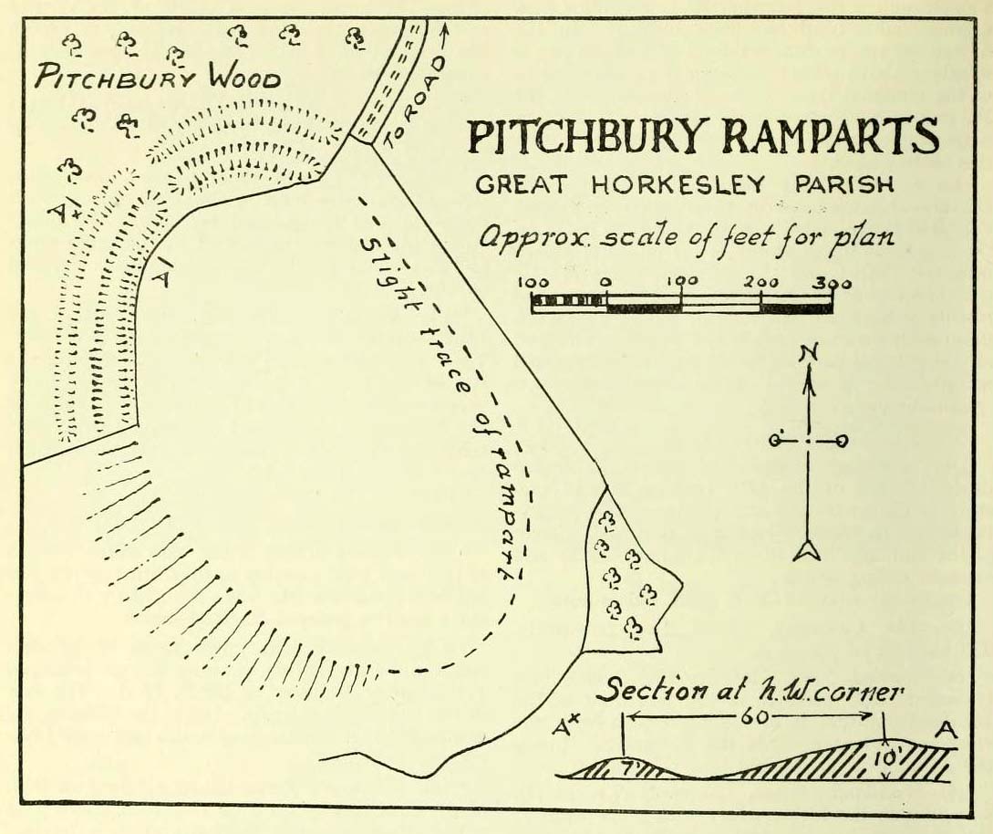
“are some remains of an earthwork known as ‘Pitchbury’ or ‘Pitsbury Ramparts.’ When the late Rev. Henry Jenkins described the camp in 1841, he stated that it was of oval shape, and contained about 6 acres. Most of it was levelled for agricultural operations about fifty years ago, but there are still some remains, consisting of two banks with their accompanying ditches. The lines moreover of that part which was destroyed, can be partially traced in the adjoining fields.”
When the Royal Commission (1922) doods wrote about the site nearly twenty years later, things hadn’t changed too much and they simply reported how the “ramparts have nearly disappeared, except for the north section.” In this “imperfect” condition, as they called it, they gave the following brief description:
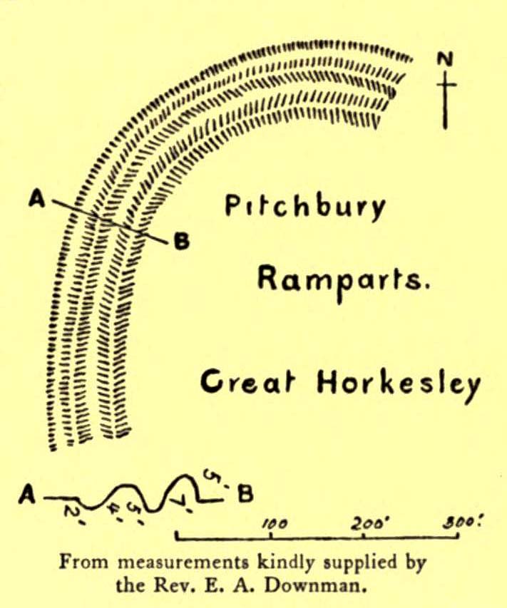
“Pitchbury Ramparts, in Pitchbury Wood, about 2 mile south of the church, are the north end of a large camp, roughly oval in shape, and defended by a double rampart and ditch. The defences are well preserved in the wood, the inner rampart being 10 ft. above the ditch, which is 60ft wide from crest to crest, but the greater part of the work has been almost obliterated by the plough, and is now only faintly discernible in a large field S. of the wood. The camp appears to have been 800 ft. long and 600 ft. wide.”
Thankfully there seems to have been no real increase in damage to the site since then. It was excavated in some detail in 1933 and again in 1973 and the finds were published by the highly reputable Colchester Archaeological Trust, whose subsequent report by Hawkes & Crummy (1995) is required reading for anyone wanting to know the detailed archaeology of this and other sites in the area.
Folklore
An intriguing piece of folklore was described in John Round’s (1882) history of the early battles around Colchester Castle. During the time when the Roman Empire was starting to crumble, the great Pictish tribes of Scotland ventured here and, we are told, took control of the Pitchbury Rings where they stayed before attacking Colchester Castle.
“Traces have been discovered of some violent catastrophe, possibly the first capture of the Colony by the marauding Picts from the North. Allured, in one of their Southern raids, by the wealth of the goodly Colony, they swooped down like eagles on their quarry from the wooded heights of ‘Pictsbury’.”
References:
Gould, I. Chalkley, “Ancient Earthworks“, in Victoria History of the County of Essex – volume 1, Archibald Constable: Westminster 1903.
Reaney, P.H., The Place-Names of Essex, Cambridge University Press 1935.
Watson, J.Y., Sketches of Ancient Colchester, Benham & Harrison: Colchester 1879.
Acknowledgements: Big thanks for use of the 1st edition OS-map in this site profile, Reproduced with the kind permission of the National Library of Scotland.
Hillfort (destroyed): OS Grid Reference –TQ 4383 8510
Archaeology & History
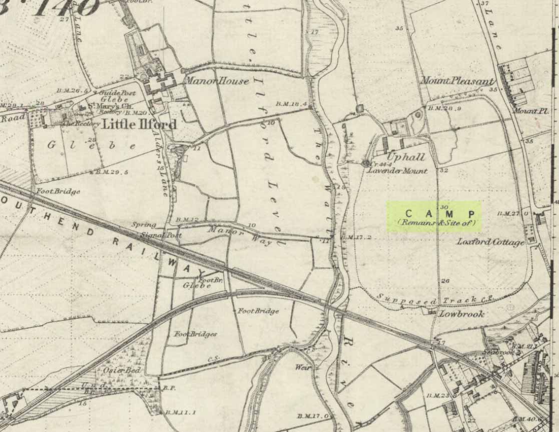
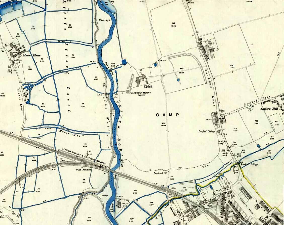
Uphall Camp, 1893
This prehistoric site was a giant – a huge colossus of an ‘enclosure’, a ‘settlement’, a ‘camp’—call-it-what-you-will. More than a mile in circumference and with an internal area of 48 acres (big enough to hold 37 football fields!), archaeologist Pamela Greenwood (1989) told us, not only that it was “the largest recorded hillfort in Essex”, but that it compared in size with the immensity of Maiden Castle in Dorset! Yet despite it being cited by the Oxford Archaeology report of Jonathan Millward (2016) as “the most significant archaeological site within the Borough” from the Iron Age period, it has fallen prey to the thoughtless actions of the self-righteous Industrialists who, as usual, have completely destroyed it. It was already in a “bad” state when the Royal Commission lads visited here around 1916, saying how it was “in some danger of destruction.” Thankfully, in earlier centuries, we did have more civilized and educated people who seemed proud to describe what there was of their local history.
Early literary accounts seem sparse; although in Mr Wright’s (1831) huge commentary to Philip Morant’s (1768) Antiquities of Essex, he thought that the adjoining parish of Barking—whose ancient boundary line is marked here by the southern embankments of the enclosure—derived from the Saxon words burgh-ing, which he transcribed as ‘the fortress in the meadow’. The same derivation was propounded in Richard Gough’s 1789 edition of Camden’s Britannia, from the “Fortification in the meadows.” It seems a more reasonable derivation than that ascribed in the Oxford Names Companion (2002) as the “(settlement of) the family or followers of a man called *Berica” (the asterisk here denotes the fact that no personal name of this form has ever been found and is pure guesswork). But according to the English Place-Name Society text on Essex by Paul Reaney (1935), the early spellings of Barking implies a derivation from ‘birch trees.’ Anyway….
Uphall Camp c.1735
A fine plan of the site was drawn by John Noble some time around 1735 although, curiously, he seems to have written no notes about the place. The first real citation of Uphall Camp as an antiquity seems to have been by Morant himself (1768). In a work bedevilled by genealogical and ecclesiological tedium, he occasionally breaks from that boredom to tell of the landscape and the people living here, mentioning our more ancient monuments—but only in passing, as illustrated here:
“Near the road leading from Ilford to Berking, on the north west side of the brook which runs across it, are the Remains of an ancient Entrenchment: one side of which is parallel with the lane that goes to a farm called Uphall; a second side is parallel with the Rodon, and lies near it; the third side looks towards the Thames; the side which runs parallel with the road itself has been almost destroyed by cultivation, though evident traces of it are still discernible.”
Just over thirty years later we were thankfully given a more expansive literary portrayal by Daniel Lysons. (1796) Lysons was drawing some of his material from a manuscript on the history of Barking by a Mr Smart Lethieullier, written about 1750 (this manuscript was unfortunately destroyed by fire, and no copies of it ever made). He told us:
“In the fields adjoining to a farm called Uphall, about a quarter of a mile to the north of Barking-town, is a very remarkable ancient entrenchment: its form is not regular, but tending to a square; the circumference is 1792 yards, (i.e., one mile and 32 yards,) inclosing an area of forty-eight acres, one rood, and thirty-four perches. On the north, east, and south sides it is single trenched: on the north and east sides the ground is dry and level (being arable land), and the trench from frequent ploughing almost filled up: on the south side is a deep morass: on the west side, which runs parallel with the river Roding, and at a short distance from it, is a double trench and bank: at the north west corner was an outlet to a very fine spring of water, which was guarded by an inner work, and a high keep or mound of earth. Mr. Lethieullier thinks that this entrenchment was too large for a camp: his opinion therefore is, that it was the site of a Roman town. He confesses that no traces of buildings have been found on that spot, which he accounts for on the supposition that the materials were used for building Barking Abbey, and for repairing it after it was burnt by the Danes. As a confirmation of this opinion, he relates, that upon viewing the ruins of the Abbey-church in 1750, he found the foundations of one of the great pillars composed in part of Roman bricks. A coin of Magnentius was found also among the ruins.”
But this is a spurious allusion; albeit an understandable one when one recognizes that the paradigm amongst many writers at the time was to say that anything large and impressive was either a construction of the Romans or the Danes, as the early British—it was deemed—were incapable of building such huge monuments. How wrong they were!
In Mrs Ogborne’s (1814) description of Uphall Camp, she thought that its form and character betrayed anything Roman and—although she wasn’t specific—seemed to prefer the idea that our earliest Britons had built this place. And she was right! She wrote:
“There is, about a quarter of a mile from Barking, adjoining Uphal farm, on the road to Ilford, an antient entrenchment, a mile and 32 yards in circumference, with the corners rounded off; the west side, parallel with the river Rodon, has a double trench and bank, and a high keep, or mound of earth, about 94 yards round the base, about nine in height, on the side of the river, and seven on the opposite side: there was an outlet to a spring of water at the north-west corner; the south side has a morass; the north and east sides are single trenched, which is almost lost by cultivation, and in some places barely discernible.”
Uphall Camp on 1873 map
Uphall Camp on 1897 map
When the Ordnance Survey lads gave the site their attention in the 1870s, they showed its real size for the first time—cartographically at least! As the two old maps either side here show, it was a big one! Although some sections of the edges of the ‘camp’ were diminishing at the time, much of it was still in evidence. And when the local writer Edward Tuck (1899) wrote about it, he told us,
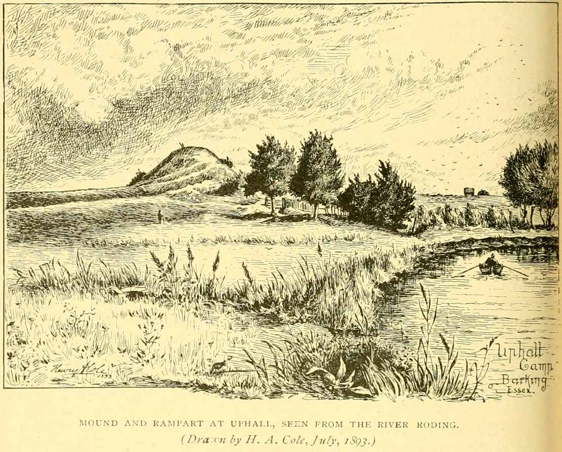
“On the north and east sides the ground is dry and level (being arable land) and the trench from frequent ploughings is almost filled up. On the south side is a deep morass; on the west side which runs parallel with the river Roding, and at a short distance from it is a double trench and bank; at the north-west corner is an outlet to a very fine spring of water, which is guarded by an inner work and a high keep or mound of earth designated “Lavender Mound.” Mrs. Ogborne in her History of Essex gives a charming drawing of this mound as it was in 1814, and says that the mound was then about 94 yards round the base, and about nine yards in height, with trees growing upon it, and its surface covered with soft verdure.”
Uphall earthworks in 1893
Several other writers mentioned the remaining embankments of Uphall Camp, which was beginning to fade fast as the city-builders spread themselves further afield. A chemical factory did most of the damage (as they still do, in more ways than one!). When the Royal Commission (1921) lads came here they curiously deemed it as an “unclassified” structure; but in those days unless things were Roman in this neck of the woods, it could unduly puzzle them! Their account of it told that,
“the remaining earthworks consist of a short length of rampart with an irregularly shaped mound at the north end, which is known locally as Lavender Mount, and another short length north of the farmhouse; there are also traces of the east side of the camp running parallel with Barking Lane. An early plan shows part of the north and east sides of the earthwork and suggests that it was roughly rectangular in outline. In 1750 the north, east and south sides are said to have had a single trench, and the west side a double trench and bank.
“The mound is 21 ft. high and 85 ft. in diameter at the base. The date of the earthwork is doubtful, but it does not appear to be pre-Roman.”
1908 photo of Lavender Mount
1814 sketch of Lavender Mount
The ‘Lavender Mount’ aspect in this monument, seemed a peculiar oddity. Even modern archaeologists aren’t sure of what it might have been, erring on the side of caution with interpretations saying it was a keep of some sort, or a small beacon hill. It might have been of course; but if it was a beacon hill, there would very likely be some written account of it – but none exist as far as I’m aware. Initial impressions when just looking at the images is that it was a tumulus, but the position of the mound on top of the raised earthen embankments tells us that it was constructed after the Iron Age ramparts. Writers of the Victoria County History (1903) said the same, suggesting a Saxon or more likely Danish origin. The area around Lavender Hill was eventually explored by archaeologists in 1960, and several times thereafter – and what they uncovered showed us a continuity of usage that spanned several thousand years!
The 1960 excavation took place where, adjacent to the embankment, “the bank and ditch contained middle-Iron Age pottery”, along with traces of the large wooden fencing-posts (palisade) that initially surrounded and protected the enclosure. In Pamela Greenwood’s (1989) archaeological report, she told us that in further digs in 1983-4 there were discoveries of neolithic and Bronze Age flint remains. The finds included,
“a leaf-shaped arrowhead and a discoidal scraper… fragments of an Ardleigh type urn, probably from a middle Bronze Age burial disturbed by later activity. An L-shaped ditch, possibly part of an enclosure or field boundary, was found during the watching-brief. It contained flint-gritted pottery, perhaps attributable to the Bronze Age.”
But the majority of the finds at Uphall came from the mid-Iron Age period. Greenwood continued:
“The settlement, judging from the relatively small area of the fortification actually excavated, was laid out in a regular way. As might be expected, the round-houses appear to be aligned, indicating some sort of street-pattern. ‘Four-poster’ structures have been located in particular areas, again pointing to some sort of designation of special zones of activity. Large quantities of charred grain from the post-pits and surroundings would confirm that these structures are granaries….
“The middle Iron Age structures are of several types: round-houses or round-buildings, pennanular enclosures, (wooden) ‘four-posters’; rectangular structures, ditches, post-holes and innumerable and ill-assorted small pits, small gullies and holes dug into the gravel. Many of the last three types are undatable and could belong to the Iron Age, Roman, medieval or later activity on the site.”
I could just copy and paste the rest of Greenwood’s report here, but it’s quite extensive and interested readers should refer to her own account in the London Archaeologist . It’s a pity that it’s been destroyed.
Standing Stones (destroyed): OS Grid Reference — NO 4128 1769
Also Known as:
Dairsie Stones
Archaeology & History
View of the field where the stones stood (Paul Hornby)
Recent archaeological investigations at the site which has become known as the Dairsie Hoard—where many pieces of broken Roman silverware were seemingly deposited in one spot, adjacent to a dried bog “which may arise from a former spring” of water—brought about the discovery of much earlier megalithic remains. The position of two previously unrecorded standing stones were found during the archaeological dig here. In the most recent edition of Current Archaeology, Fraser Hunter (2018) described the position of the Roman silverware close to some ancient pits or sockets in the ground. This “group of features was…intriguing”, he told,
“for two of them contained stumps of standing stones, one in association with probably Bronze Age pottery. This hoard had been buried in a memorable, perhaps even a sacred site, between an intriguing wet spot on one side and, on the other, two standing stones, which were already ancient by the time the silver was buried. Such burial of valuables in association with prehistoric monuments can be readily paralleled elsewhere. It suggests this silver was placed under the care of the gods, probably as a sacrifice rather than a burial for safekeeping.”
Two thousand years before the Roman silver deposit had been deposited, megaliths here stood. Sadly they’re long gone, leaving more questions than answers as usual…
References:
Hunter, Fraser, “Solving a Silver Jigsaw,” in Current Archaeology, 335, February 2018.
Acknowledgments: Many thanks to Paul Hornby for use of his photo in this site profile.
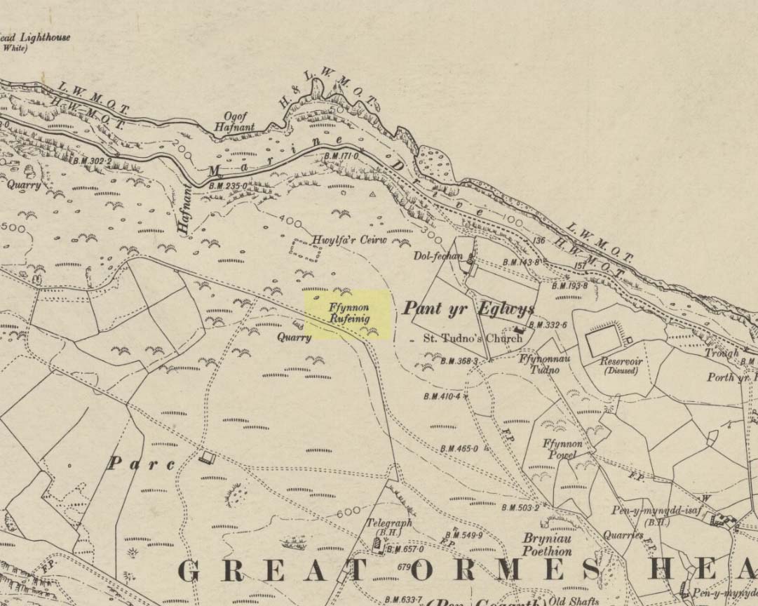
To be found on the legend-filled landscape known as the ‘Great Orme’, this ancient well was highlighted on the 1901 OS-map of the region, on the south side of the track. Sadly, despite an occasional puddle that fills the old trough when She rains, its waters are no longer running. H.C. Jones (n.d.) informed us that this was a ‘Roman Well’, which tradition said was a place they used when they invaded this part of Wales, although Paul Davies (2003) thought this “to be wishful thinking”.
Despite this, in recent years the walling around the well has been rebuilt by the track-side and a stone plaque with the words ‘Roman Well’ has been mounted to tell you that you’re at the right place.
References:
Davies, Paul, Sacred Springs, Blorenge: Llanfoist 2003.
Jones, H. Clayton, “Welsh Place-Names in Llandudno and District” in Mountain Skylines and Place-Names in Llandudno and District, Modern Etchings: Llandudno n.d. (c.1950)
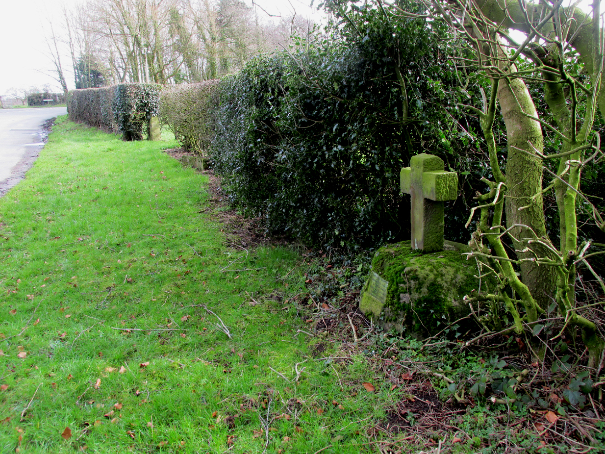
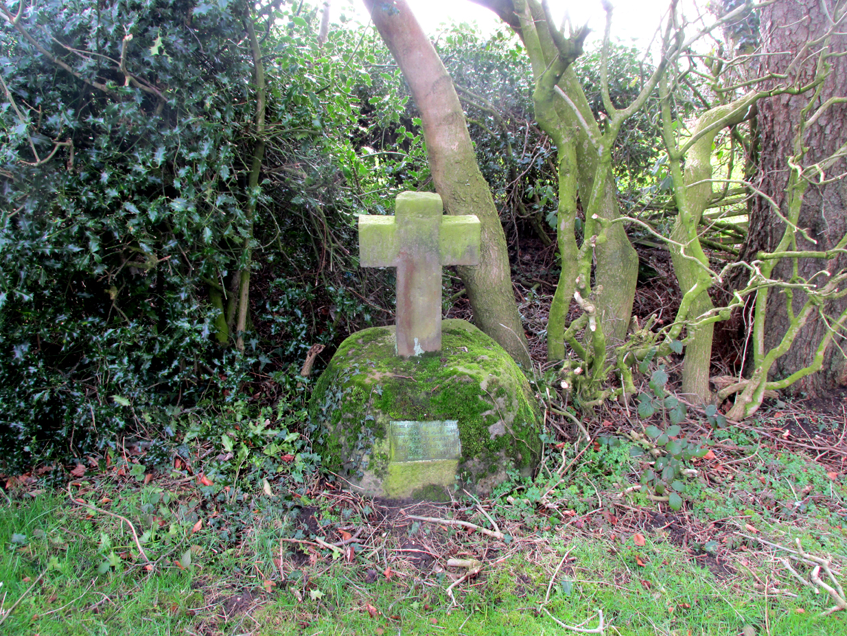
The cross is situated on the verge at the west side of the B5269 road near its junction with Ashley Lane at Stump Cross, north-east of Goosnargh.
Archaeology & History
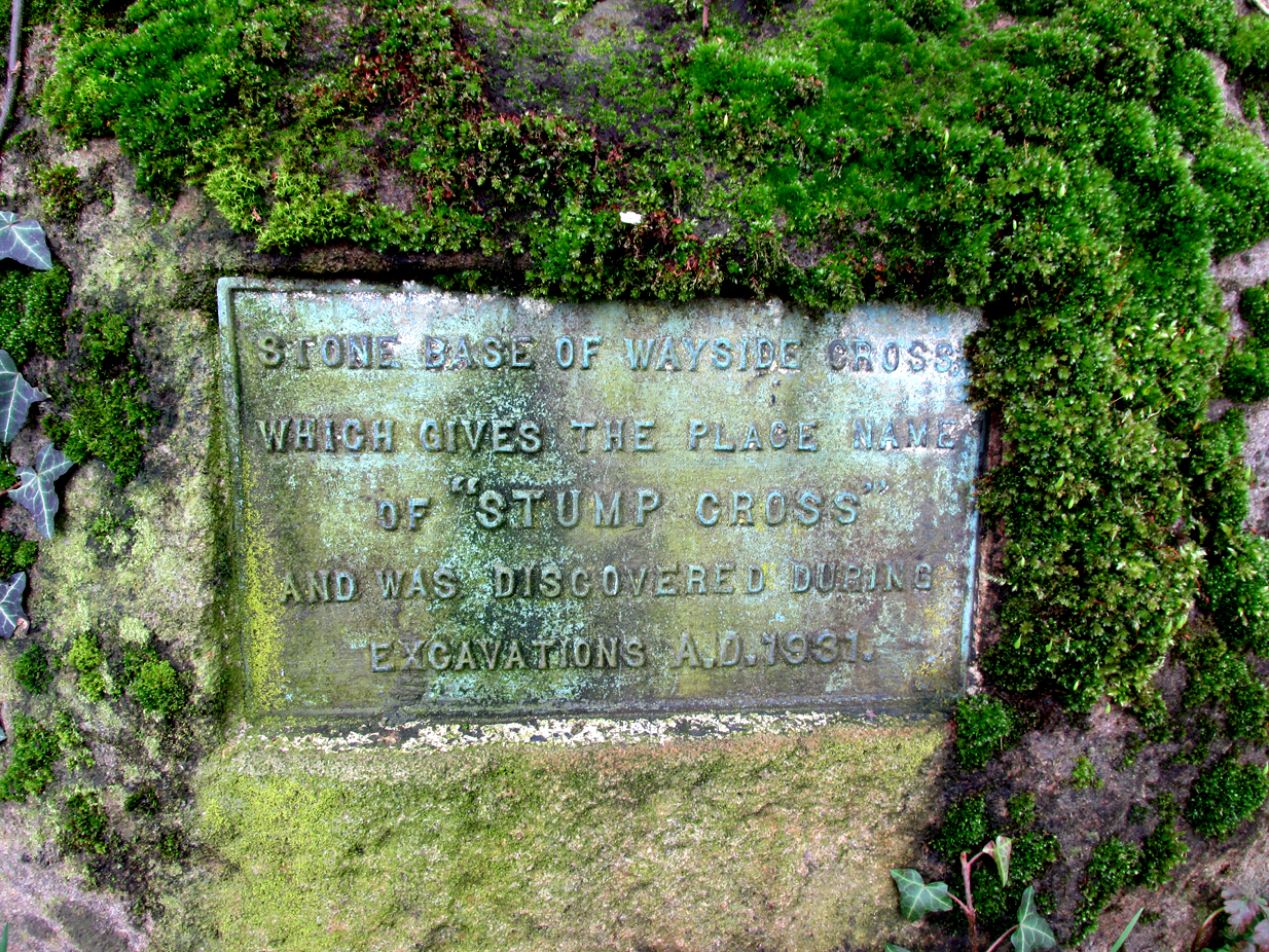
All that survives is the socketed base of the mediaeval cross, into which a small modern carved stone cross has been inserted. A bronze plaque attached to the base informs the reader that the cross gives its name to the locality, and that the base was discovered during excavations in 1931.
Richard Cookson (1888), in his Goosnargh Past & Present, writes:
“We have the remains of several upright crosses in this township called “cross stones” all being placed near to some public road or path. The corpses of the Roman Catholics are rested at those stones on their way to internment, and those funeral attendants who are of that persuasion kneel down and offer up a short prayer for the repose of the soul of the departed individual whose body they are conveying to the grave.”
Further to the destruction of crosses in the township, Cookson writes:
“…the Reverend Richard Wilkinson, late minister, of anti-Romanistic notoriety, in his frenzied hostility to the Roman Catholics, caused [the cross] to be broken up and removed…”
The site is listed by Henry Taylor, in his 1906 magnum opus on Lancashire crosses, and speaking generally on the destruction of wayside crosses in the Hundred of Amounderness, he writes:-
The bronze plaqueModern cross inserted into the Mediaeval socket
“The destruction of so many crosses, which at one time existed in this part of the Hundred, is due to the vandalism early in the nineteenth century of a vicar of Goosnargh, named Wilkinson. He was a vehement Protestant, and owing to his notoriety as a Prophet, was allowed to do much as he liked with these ancient monuments. Many crosses, indeed, it is said, were pulled down with his own hands. His prophesies foretelling the deaths of various persons often unfortunately came true, and he was thus, in this superstitious part of England, dreaded as a wizard. As this work of demolition took place before the date of the Ordnance Survey, there were in all probability many more crosses erected in Mediaeval times in this district than we have now any knowledge of, and it is quite possible that some of the crosses so recklessly destroyed may have been, like those at Halton and Heysham, of pre-Norman date and of great historical value. Fragments of them might even now be found were a diligent search be made.”
Further to this speculation as to the antiquity of these destroyed crosses, it is interesting to note the approximately parallel orientation of roads and field boundaries to the east of the Stump Cross. This may point to the area having been subjected to Roman survey, and the site of the Stump Cross having once been a shrine to the gods of the agrimensores (Roman surveyors) that had been Christianised.
References:
Cookson, Richard, Goosnargh: Past and Present, Preston, H.Oakey, 1888.
Taylor, Henry, The Ancient Crosses and Holy Wells of Lancashire, Manchester, Sherratt and Hughes, 1906.
Richardson, Alan, The Roman Surveyors in Cumberland, P3 Publications: Carlisle 2008.
From the old cross in the middle of the village, walk along the A820 Balkerach Street main road (NOT down George Street) until you reach Station Wynd on your right. Walk up here for 100 yards towards the new housing estate (don’t buy these places – they’re dreadful quality beneath the veneers) and there, on a small grassy rise on the left just before the car park, stands our stone!
Archaeology & History
This little-known monolith on the northern edge of little Doune village, was recently moved a short distance from its original position thanks to another one of those sad Barratt housing estates being built here; but at least it has received protection with the surrounding fence and notice board telling its brief history and folklore (better than being destroyed I s’ppose).
Stone on 1866 OS map
Standing less than five feet tall, local lore tells that it has been moved around close to this spot several times in the last couple of centuries. Although not mentioned in Hutchinson’s (1893) essay on local megaliths, the stone was highlighted on the 1866 Ordnance Survey of Doune, where the non-antiquated lettering showed how it was thought to be Roman in origin, not prehistoric.
Folklore
Trysting Stane, looking NE
The name of the stone comes from it being used as a place where deeds were sworn, with the stone as witness to the words proclaimed by both parties (implying a living presence, or animistic formula of great age). This activity was continued in the local ‘trysts’ or cattle fairs held a mile away, where buyers swore the sale of cattle at this stone—again with the stone being ‘witness’ to the spoken deals. It was also used as a counter where gold was exchanged for cattle bought and sold during the Michaelmas and Martinmas Fairs. Sue Harvey (2006) told that this standing stone,
“was called the Devil’s Head and was used during past Doune fairs to count gold on when cattle were being bought and sold.”
In local newspaper accounts from the 1950s, local historian Moray S. Mackay (1984) told how the children of the village used to gather round the stone, holding hands, and sing,
Olie Olie, peep, peep, peep,
Here’s the man with the cloven feet,
Here’s his head, but where’s his feet?
Olie Olie, peep, peep, peep.
Notice board telling its tale…Looking at the stone on its rise
This implies the stone once possessed a myth relating to a petrified ancestral deity of animistic (pre-christian) origin, but as yet we have found no additional information allowing us a confirmation of this probability. A correlate of this theme—i.e., of the stone being the head of a deity—is found in West Yorkshire (amongst many other places), where one of the little known Cuckoo Stones was once known to be a local giant until a hero-figure appeared and cut off his head, leaving only his body which was then turned to stone. Mircea Eliade (1958; 1963) cites examples of animistic religious rites and events explaining this early petrification formula via creation myths, etc. (we find very clear evidences of animistic worldviews and practices still prevailing in the mountains just a few miles north and west, still enacted by local people)
Folklore also alleged that the stone was Roman in nature, but neither archaeology nor the architectural form of the stone implies this. Roman stones were cut and dressed—unlike the traditional looking Bronze Age, rough, uncut fella standing here.
References:
Eliade, Mircea, Patterns in Comparative Religion, Sheed & Ward: London 1958.
Eliade, Mircea, Myth and Reality, Harper & Row: San Francisco 1963.
Harvey, Sue, Doune and Deanston, Kilmadock Development Centre 2006.
Hutchinson, A.F., “The Standing Stones of Stirling District,” in The Stirling Antiquary, volume 1, 1893.
Park by the church, which has a Sheela Na Gig and some roman stones. Walk back to the A153 (Ancaster Cross roads), turn left and cross the road. Take the footpath which is on the south side of the A153 and bear right into the nature reserve. The well – a large pool – is on private land, but it can be seen to the right of the entrance to the reserve.
Archaeology & History
This spring was possibly known in Roman and pre-Roman times, as there is a Roman station settlement hereby. Roman credentials have been strengthened since Time Team’s research which found that the site was the focus of a cult. There was an inscribed stone, found in the church and originally part of an archway, which says:
DEO VIRIDIO TRENICO ARCVM FECIT DE SVO DON
Translated to:
‘For the god Viridius, Trenico made this arch, donated from his own funds.”
The Time team archaeologists found a late Roman or early Dark Age burial with a similar inscription ‘DEO VRIDI SANCTO – ‘To the holy god Viridius.” The show thought that the God was associated with agriculture, but with the proximity of the spring nearby, perhaps they missed an obvious connection. It seems very likely that the Romans would have known of the spring as the valley beside it is thought to be a Roman raceway and the town was only a few yards away.
The spring is not mentioned historically; for example Leland (1535-43) notes a chapel and hermitage, but no well:
“The area wher the castelle stoode is large, and the dikes. In the highest ground of the area is now an old chapel dedicate to S. Marie, and there a her(em)ite.”
Lady Well on 1858 map
In Victorian times the water was tapped as a source of water for the village and a large cistern and pipe system established. According to Thompson (1999) in his work on Lincolnshire springs and wells, this was later removed and the well had become a boggy area, before finally being restored and clay-lined to be stocked with fish and prevent water loss. Its water now appears to be a light greeny-blue as a result. One cannot directly reach the edge of the water as it is enclosed in fencing but it can clearly be seen from the footpath.
Folklore
No tradition appears recorded regarding it properties. However, it appears likely that this is the spring Rudkin (1936) notes as St. Helen’s Well or Mucky Pool in the legend of Byard’s Leap, the famed story associated with a local witch as the story has association with Ancaster – although this could record another site.
References:
Parish, R. B., (2012) Holy wells and healing springs of Lincolnshire
As with many prehistoric sites, this too was unearthed and seemingly destroyed in the 19th century. Although it seems that nothing now remains of the place, the english archaeological fraternity have the site listed as a “Romano-British site”, which seems reasonable; although the lay-out of the barrows or tumuli described and portrayed in the sketch here give a more traditional Bronze Age look. But we may never know for sure. Thankfully a fellow antiquarian called Walter Field (1863) was on hand to make a record of the place before its final destruction. In a short paper he wrote for the Essex Archaeological Society, he told that:
“In the Spring of 1858, a number of labourers were employed in trenching some fields belonging to Holme Farm, forming part of a large tract of land called Bulphan Fen, and situated about a mile-and-a-half west of the village of North Ockenden. In the course of their operations they found a number of beds of dark soil, in which were a large quantity of bones, supposed at first to be human, together with fragments of pottery and pieces of charcoal. It was the general belief among the workmen that the field had been the scene of some great battle, a belief supported by some local traditions. One thing seems certain, that it is the site of a Roman or early British Burial Ground, extending over a space of about sixteen acres; but whether it marks the battlefield of one of those many great struggles which took place in this county between the Britons and Romans, or whether it denotes the peaceful cemetery of a Roman Station, it is perhaps not very easy to determine.
“The little evidence, however, which the plough and the harrow have left remaining, seems in favour of the latter. The regular and almost equidistant arrangement of the lines of dark soil in many parts, and the many fragments of cinerary urns found in nearly all of them, seem to indicate rather the orderly interment of a cemetery, than the more hasty burial of a battle-field; but this is by no means conclusive.
“The graves are at once discernible from the surrounding soil, the natural soil being a yellow clay, whilst the earth of the graves is nearly black. It is impossible, with any accuracy, to trace the exact forms of the graves, some appear to be circular, and to vary in size from 10 to 40 feet in circumference, others appear to be of an oblong form; one grave is much larger than the rest, and is of about 60 feet in length and 20 in width. There are doubtless more of these graves in the bordering fields. It is worthy of note that a neighbouring meadow is called the Church Field, and a portion of the land on which these discoveries were made is still called Ruin Field. Both these names, probably, have reference to the formerly uneven sur&ce of the ground, caused by a great number of burial mounds. The fragments of Pottery vary much in their character, some being of the very rudest workmanship, whilst others have been more carefully manufactured; and a few small pieces of Samian Ware were found; mingled with them, were the bones of different animals — the horse, the deer, the boar, etc., but no human bones; much of the earth, stones, and pieces of wood bear evident marks of the action of fire; beyond these there was nothing found, except a portion of a flint arrow-head and a part of a hand mill stone. Not a single coin or piece of metal was discovered. The circumstances that all the fragments of pottery, and nearly all the bones of animals, are broken up into small pieces lying equally at the bottom as at the top of the dark soil, and that the graves are about three feet deep, narrow at the bottom and widening to the surface, lead me to think that the present graves are only the trenches of the original barrows, but that the field has been gradually levelled for agricultural purposes, and that the plough and the spade have in process of time filled up the original trenches with the soil, urns, bones, &c., of the burial mound.”
References:
Field, Walter, “Discovery of British and Roman Remains at North Ockenden and White Notley,” in Transactions of the Essex Archaeological Society, volume 2, 1863.
This site entry is dedicated to Sarah Hunt, once of North Ockendon, wherever she may be…
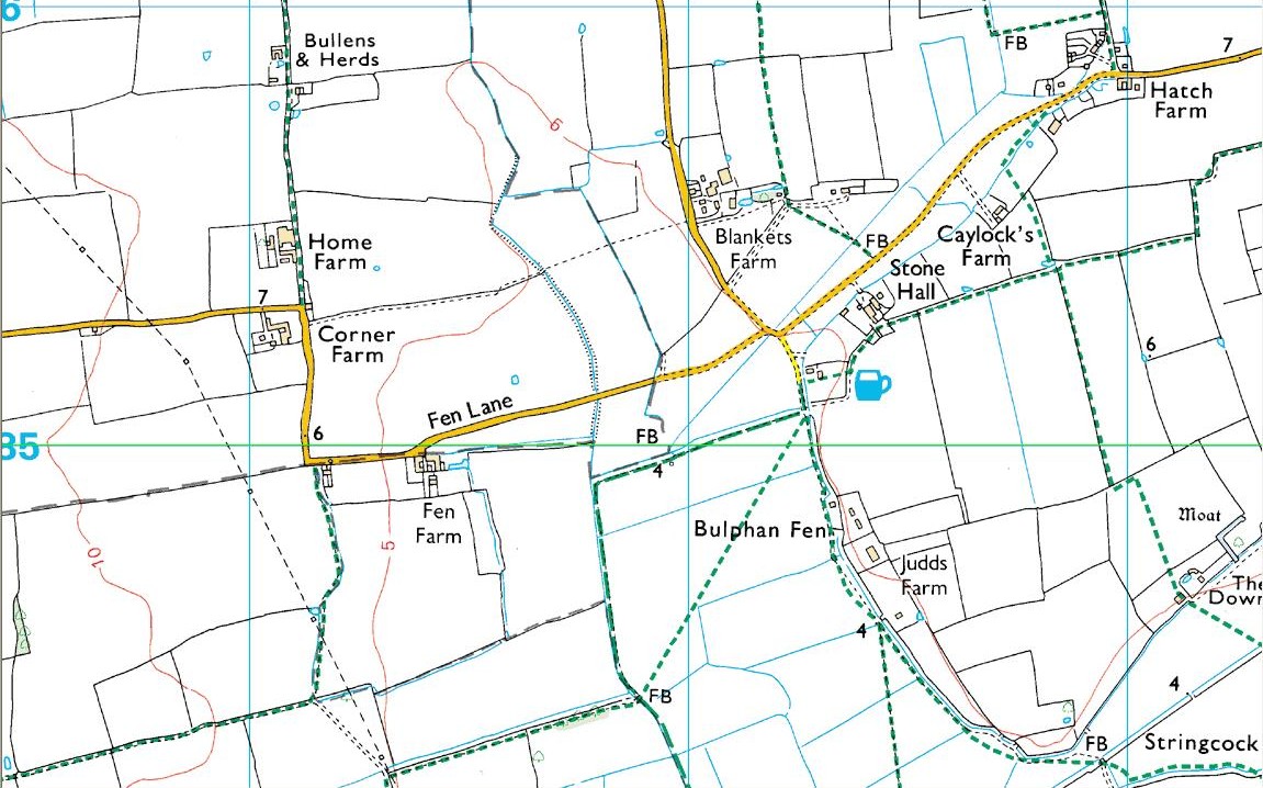
The best way to get here (when we went anyway, quite a few years back now), was via the old church . At the entrance to the church there was a signpost to the tumuli. Take the footpath to the left of the building and walk about 200 yards. Once you go under the railway bridge and into the trees, walk left and the overgrown mounds appear in front of you!
Archaeology & History
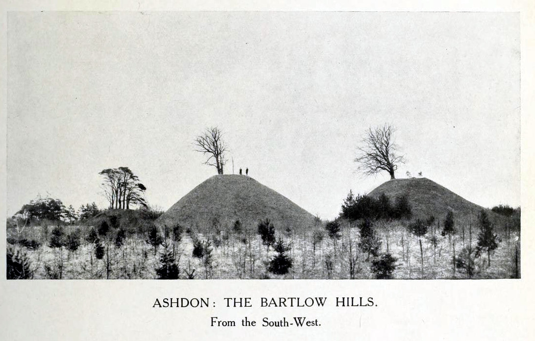
Thought to the largest Romano-British barrows in England, this was an incredible clump of giant burial mounds which, in more recent years, have been allowed to fall into neglect. Although a railway was built through this clump, it bypassed the main tumuli—and in doing so uncovered another cemetery! Four large barrows still remain and access, though alleged by some of those southern-types to be on private land, didn’t stop our foray here. The usual “private” signs showing just how unwelcoming some of them are, just made us Northerners more determined to find ’em! But that aside…
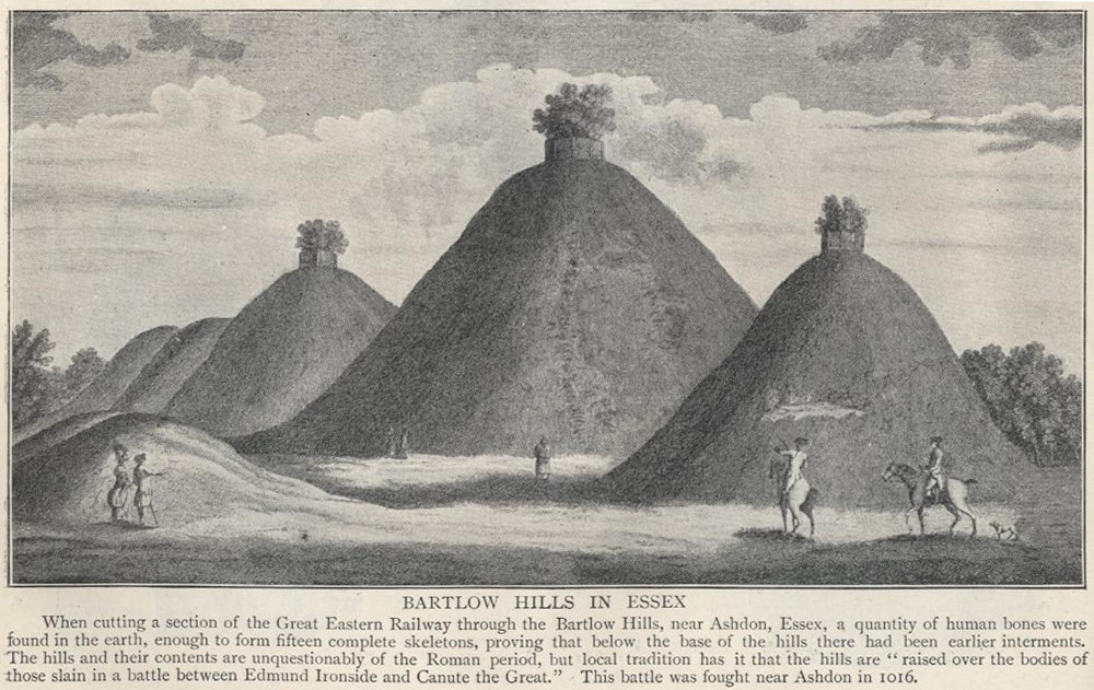
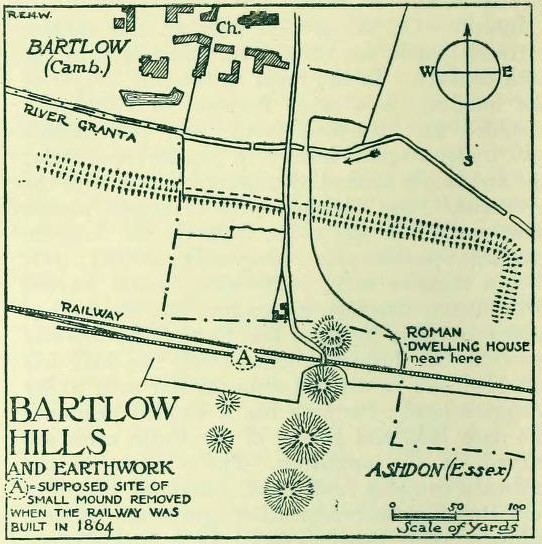
18th century drawing of the hills1916 map & plan
Although nowadays classed as being in Cambridgeshire, when the Royal Commission lads visited the site and described it in their Inventory (1916), the mounds were in the parish of Ashdon on the northern edge of Essex. But now it comes under the parish of Bartlow in Cambridgeshire—which seem sensible, as the word ‘bartlow’ itself stems from these very monuments. As the regional place-name expert P.H. Reaney (1943) told, Bartlow means,
“‘(At) the mounds of the birch trees,’ OE (æt) beorca-hlãwum, (from the verb) beorc, hlaw, i.e., the great Bartlow Hills tumuli which dominate the church and village.”
Described as early as 1232 CE as Berkelawe, these hills were opened in the middle of the 19th century and found to possess a mass of Roman remains. A number of articles in the journals of the period gave extensive descriptions of what was uncovered, but they are summed up nicely in the Essex Royal Commission (1916) report, which told:
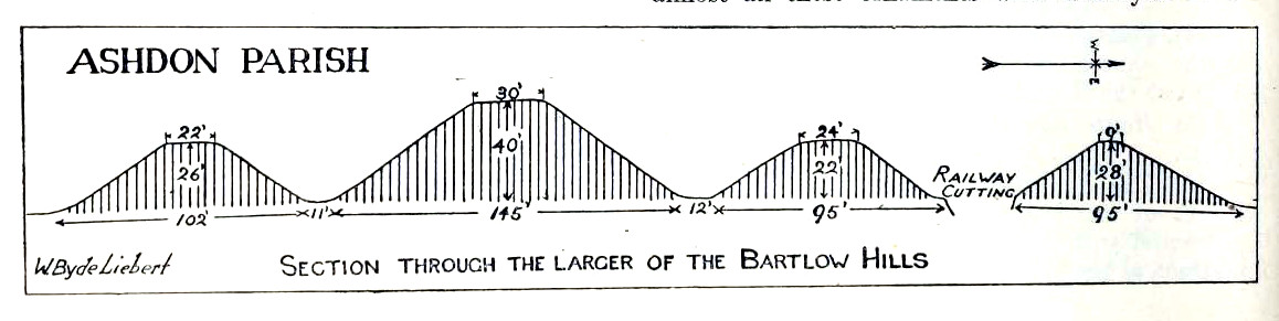
“The principal monuments are the Bartlow Hills, which lie…at the extreme N.E. of the parish. They form (or formed) two parallel rows, running nearly N. and S. The eastern row consists of four large steep-sided mounds, in shape truncated cones, the largest 40 ft. high and 145 ft. in diameter; since 1760 three of the mounds have been planted with trees. The western row is now less clear: originally, it consisted of at least three small mounds, as was proved by digging in 1832; only two can now be faintly traced. Excavations, chiefly in 1832-40, have shown that all seven mounds contained at the centre regularly walled graves, within which was very costly grave-furniture of glass, decorated bronze, and enamel; almost all these ornaments were destroyed in a fire at Easton Lodge in 1847. The graves seem to belong to the end of the first and beginning of the second century and were doubtless built for Romanized British nobles of the district. The particular method of burial occurs especially in eastern England and in Belgium, and is native, not Roman, by origin.
“…Other burials have been noticed near the Hills — one with a flint axe and knife, presumably prehistoric. A small dwelling-house was found in 1852 about 100 yards E. of the Hills — mainly, if not wholly, within the Cambridgeshire border — but nothing of it is now visible on the surface.”
Section & sizes of the tumuli, 1916
The sites are very impressive indeed, though as we can see from the old images, when they were clear of trees they stood out much clearer.
Folklore
Old fairs used to be held at the Bartlow Hills, whose origin goes way back. There is also a curious custom which probably originated in some way from traditional beating of the bounds of the local township boundaries, narrated by folklorist Enid Porter. (1969) Throughout the region she reported how “skipping was performed on Good Friday”. It commenced at 10am and would continue into the evening. Porter wrote:
“An eighty year old woman of Linton recalled in the 1930s that in her youth the villagers of Linton and Hadstock used to skip on Good Friday to Bartlow Hills to join in the fun of the fair held there.”
An early legend uncovered from archives by Leslie Grinsell told that here could be found a “treasure chest said to have been concealed by Oliver Cromwell in the barrows known as the Three Hills, or in pits near them.”
…to be continued…
References:
Porter, Enid, Cambridgeshire Customs and Folklore, RKP: London 1969.
Reaney, P.H., The Place-Names of Cambridgeshire and the Isle of Ely, Cambridge University Press 1943.
Royal Commission on Historical Monuments, England, An Inventory into the Historical Monuments in Essex – volume 1, HMSO: London 1916.