Cup-and-Ring Stone (destroyed): OS Grid Reference – NO 379 204
Archaeology & History
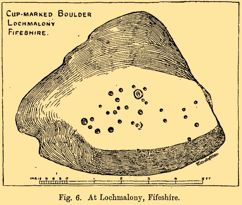
J.R. Allen’s 1882 sketch
Here’s another old carving that has succumbed to the lack of animistic respect endemic in modern culture. Ronald Morris (1981) reported that this carved rounded boulder was “dynamited by the farmer and (is) now no longer extant.” First described in 1882 and later included in the Fife Inventory (1935), the large smooth rock used to lay within a nice copse of dense gorse, measuring 2½m x 1¾m across and about 1m high from ground level.
It was uncovered in 1872 and mentioned briefly for the first time in Arthur Mitchell’s (1874) fine essay on the antiquities of Cromar, where he told that “Dr. Batty Tuke tells me there is a cup stone on a moor forming part of Lochmalonie farm, in the parish of Logie, Fifeshire.” His notes were followed up by the great Romilly Allen (1882), whose sketch is all that remains of this ancient site. The carving was subsequently included in one of Ron Morris’s (1981) survey of Scottish petroglyphs, describing it simply as,
“2 cups-and-one-complete ring (one mostly weathered off), diameters 10cm (4in) and 27 cups (carving depth and angle of slope not now known.”
Its isolation from any other known petroglyphs is a little odd and there is every possibility is accompanied a prehistoric burial of some sort; although from the attitude of the farmer, all trace of that would have gone too. On a more positive note, when Batty Tuke spoke with Romilly Allen about this carving, he told that he has “frequently noticed well-marked cups on dry stone dykes in the Glenduckie area.” Petroglyph explorers amongst you might want to spend some time meandering in this neck o’ the woods….
Morris, Ronald W.B., “Fife: Loch Maloney – Cup Marks,” in Discovery & Excavation, Scotland, 1967.
Morris, Ronald W.B., The Prehistoric Rock Art of Southern Scotland, BAR: Oxford 1981.
Royal Commission on Ancient & Historical Monuments, Scotland, Eleventh Report with Inventory of Monuments and Constructions in the Counties of Fife, Kinross and Clackmannan, HMSO: Edinburgh 1935.
Take the single-track Glen Lochay road down past the Bridge of Lochay hotel at the edge of Killin, as if you’re gonna visit the superb cup-and-ring carvings opposite Stag Cottage (or Duncroisk 1). Immediately past the garden of Stag Cottage is a small copse of trees and a couple of old wartime-looking buildings in the field above the roadside. Go up past these buildings and onto the rise at the back. You’re here.
Archaeology & History
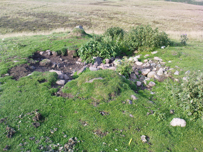
This is a fascinating site of multi-period historical usage, which Dugald MacInnes (2001) thinks may have its origins in the early Bronze Age or neolithic; but which I reckon was probably first used in the Iron Age. Either way, we have here a large interesting well-preserved prehistoric stone enclosure, that has yet to be excavated. I first came across it whilst gathering firewood from the adjacent copse and was quite puzzled by what seemed to be an extensive curved line of ancient walling running from its east to northeastern section, typical of prehistoric Iron Age walled structures common in northern England and beyond. I must have paced back and forth along a 75 yard length of this section of walling a half-dozen times, wondering what the hell this place was. And the more I looked at this section of the enclosure, the greater my conviction grew that this was constructed in prehistoric times. And thereafter came the puzzle.
Looking down at the walled enclosureNW section of walling
For along the southern walled section were a number of much more modern medieval and much later walled sections, including the remains of buildings that looked barely Victorian in age and nature. The site was obviously being used presently by the local farmer for his cattle. And so it became obvious that here was a large oval-shaped stone-walled enclosure or settlement that had been used over and over again through many centuries, with its origins seeming to be Iron Age in nature. Measuring approximately 195 yards (178m) in circumference, the structure has a maximum E-W diameter of 78 yards (71m) and N-S measurement of 44 yards (40m).
The mass of evidence for prehistoric activity is all round this hidden enclosure, with the fascinating clusters of cup-and-ring stones of Duncroisk and Corrycharmaig close by. The small standing stones of Tirai 600 yards NW, and a similar prehistoric enclosure at Tullich ¾-mile NW show ample evidence of prehistoric man in this part of Glen Lochay.
Despite the size of the place, no literary reference of it occurs before MacInnes and his team came here. His description is as follows:
“An oval enclosure, its boundaries formed principally from large water-worn boulders interspersed with drystone walling and in part by an earthen bank in the easternmost section, sits atop of a natural terrace about 155m OD. The terrace slopes steeply to the west and south and cut into the western slope is a track, the course of which cannot be determined beyond the extent of the slope. This track displays revetment in the form of stone coursing.
“The SW corner of the enclosure is angular rather than the rounded character of the other sections. The W and SW sections are composed of coarsely constructed stonework in which large, 1m wide, often 1m high, water-worn boulders at two to three metre intervals, are interspersed with smaller boulders which form crude drystone coursing.
“The NE section is formed largely of large boulders, one of which is 1.5m in width and 1.2m high by 0.8m wide. Sections of the northern part would appear to be robbed out, perhaps to construct the modern wall which lies about 25m to the north. There are no remaining large boulders there, however, which could indicate their absence in the original construction of the enclosure. The central section of the northern perimeter may be constructed of two outer skins of boulders, forming a wall about 0.9m wide, 0.4m high on its exterior, but reducing to 0.3m on its interior side. Two sections could possibly be filled with a rubble core.
“The E section is formed by a low 0.3m high earthen grass-covered bank with occasional boulders. This bank is about 0.2m high relative to the interior, but is about 0.5m to.0.8m high on its exterior side. The NW side shows on the western side more evidence of double skin, rubble construction. Close inspection of the stonework around the perimeter of the enclosure has revealed no evidence of shot-holes. However a monolith situated in the NE has been split, but this would appear to be natural. The interior of the enclosure is more or less level and grass-covered. There is however, a slight drop in level in the western third of the interior. This is defined by a linear slope which may be a lynchet.”
Northern section of enclosureUpright stone in eastern wall
Northeast of the enclosure about 40 yards away is the normal drystone walling running along the sloping hillside. But more intriguingly to archaeologists is the second line of much more ancient walling 76 yards (70m) further up the grassy slope, running at an angle across and uphill in a northwesterly direction. This line of walling has a distinctly Iron Age flavour to it and is composed of some very large upright monoliths, almost Bronze Age in nature! It continues into the next field for some 400 yards and onto Duncroisk Burn — the other side of which we find another line of ancient walling with an impressive cup-and-ring stone incorporated.
There’s tons more to be said of this region…
…to be continued…
References:
MacInnes, Dugald, An Archaeological Field Survey of a Deserted Settlement at Duncroisk Farm, Glen Lochay, Association of Certified Field Archaeologists: Glasgow 2001.
You can come here from either Dunblane to the north, or Bridge of Allan immediately south: either way you reach the site by going along the A9 road until you reach the Lecropt Church, a half-mile north of Bridge of Allan. On the other side of the road is a somewhat battered wooden gate. Go through here and up towards the tree-covered hill, following its edges to the right for a few hundred yards, until you come to another very large mound covered in trees. That’s what you’re looking for!
Archaeology & History
Described on early OS-maps as a “Supposed Roman Camp,” this large fortified stone hillock has more recently been considered a creation of indigenous Scots. Hemmed in and hidden on most sides, by the rises of Knock Hill to the west and Gallows Hill to the east, the only lines of visibility out of the fortress is along a northwest to southeast corridor, keeping the site quite secret to outsiders. It would have been a fine place for a small community in ages not-so-long-ago, keeping the people hidden from the pestilent invasions of both Romans and english in bygone times.
The tree-clad fort, through blizzard
The large raised oval enclosure was walled around its sloping sides and edges, with remains of a walled embankment still visible running around the top of the slopes. What may have been traces of hut circles were on top of the hillock until recent times, but these have been much reduced by some digging near the middle of the site. It would appear that an ‘entrance’ was once visible on the southeastern side of the fort, but when we came here the other day, a lovely blizzard covered the place in snow, so this was difficult to see.
When the Royal Commission chaps came to visit the place in 1979, they didn’t really say much about the place, merely telling of its dimensions, saying:
“This fort measures 48m by 32m within the remains of a single rampart 4.5m thick and 1m high.”
I’m sure there must be much to be said of this lovely old site by local antiquarians, but I haven’t found much as yet. But if you’re wanting a nice quiet spot to sit for a while on the outskirts of Stirling and Dunblane, I’d heartily recommend visiting this place. Badgers and deer also seem to like the place!
References:
Royal Commission on the Ancient & Historical Monuments of Scotland, Archaeological Sites and Monuments of Stirling District, Central Region, Society of Antiquaries of Scotland 1979.
On the A657 road, a half-mile past Greengates towards Calverley, just before the road starts going uphill, take the lower dirt-track of Eleanor Drive on your left into Calverley Woods (here known as West Woods). About 150 yards along the track, note the small footpath on the right which goes up diagonally further into the trees. Go along here until you reach the remains of a dried-up pond on your left. The carved stone is about 10 yards before the pond, just above the footpath.
Archaeology & History
Rubbing of the 2 cupmarks
Another stone only for the puritans amongst you! This (and the West Woods 2 carving) was one we found in 1985 when we were exploring the woods looking for the Calverley Woods cup-marked stone reported by Sid Jackson in the 1950s. The stone is a small roughly oblong, earthfast rock, about 2ft by 1ft across, and has two distinct but faded cup-marks on its slightly sloping face. That’s it!
Soon after first finding this, we made a couple or rubbings of the stone, one of which I reproduce here and which shows the two cup-marks. You’ll note the measurement and note of the cups being 2 megalithic inches (MI) in diameter. The MI was a statistical unit of measure suggested by the late great Alexander Thom, who found regular integers of 2.07cm in many of the cup-and-rings he examined, and so surmised it as a deliberate numeric system. At the time when we found this cup-marked stone, I was exploring Thom’s idea and was very much taken up with it. However, after a few years doings numerous rubbings of the many cup-and-ring stones in West Yorkshire, and exploring the simple size of the human hand and how we execute cup-markings on rocks, I found Thom’s idea didn’t seem to be realistic. (though I still love Thom’s works: the man was an outstanding researcher, far exceeding all the archaeologists of his period in terms of his exploratory methods)
References:
Bennett, Paul, “The Undiscovered Old Stones of Calverley Woods,” in Earth 2, 1986.
From Marsden itself, take the A62 road west and where the road bends round, the large hill rising on your left is where you’re heading. There’s a parking spot near the bottom of the highest part of the hill. From here, walk right to the top, up whichever route you feel comfortable with. At the very top is an intrusive modern monolith (dedicated to somebody-or-other, which the fella wouldn’t approve of if he really loved these hills*). About 10 yards east of the stone is a small grassy mound with a bittova dip in the middle. That’s it!
Archaeology & History
This is a little-known prehistoric site, whose remains sit upon a very well-known and impressive hill on the western edges of Marsden. Described in Roy Brook’s (1968) excellent survey on the history of Huddersfield as “the most important site” from the Bronze Age in this region, it seems curious that the attention given to it has been relatively sparse and scattered. The tops and edges of the hill have been cut into and worked upon by the uncaring spade of industrialism (of which there is much evidence), aswell as much of the peat being used for fuel over countless centuries — some of which appears to have been cut close to the all-but-lost remains of this once-important burial site.
The first description of the hill itself seems to be in 1426, where it was named in the Ramsden Documents, “past’ voc’ le Pole.” (Smith 1961) It wasn’t until appearing as Puil Hill on the 1771 Greenwood map that the title we know of it today began to take form. Local people would alternately call it both Pule and Pole Hill. But its name is somewhat curious, as the word appears to derive from the variant Celtic and old English words, peol, pul and pol,
“meaning a pool or marsh, especially one that was dry in the summer. Pole Moor therefore means Pool or Marsh Moor…and Pule Hill = the hill in the marsh.” (Dyson 1944)
Remains of mound looking NWSmall mound at left-centre
However, in Smith’s English Place-Name Elements, he gives an additional piece of word-lore which seems equally tenable, saying the word may be “possibly also ‘a creek'”, which could be applied to the water-courses immediately below the west side of the hill. We might never know for sure. But the archaeological remains on top of Pule Hill have a more certain history about them…
The burial site first appears to have been mentioned in a short article by Henry Fishwick (1897), who wrote:
“Whilst searching for…flints on the summit of Pule Hill a few weeks ago a discovery was made which is of considerable antiquarian interest. On the highest point of the hill, and from 12 to 18 inches below the surface, were found two human skeletons lying on their sides almost directly east and west, the knees of both being drawn up. Near to them were two small circular urns measuring 4¾ inches high, 5 inches across the top, and 6 inches in diameter at the widest part, the base being 3 inches across. These are made of native clay very slightly burnt, and are ornamented with short lines (apparently cut with some sharp instrument) which forms a rough herring-bone pattern. On the centre band are four ears or small handles which are pierced so as to admit a small cord. The urns contained animal matter and a few calcined human bones.
“Since the discovery of these two urns another has been exhumed from the same place. It measures 3½ inches in height and 7 inches in diameter at the widest part, which is just below the rim of the mouth. Its ornamentation is similar to the others, but quite so elaborately executed; the base is made with four feet or claws. On one side of the urn is an ear or handle pierced with a small hole in the direction of a double-groove, in which it is placed; there is a second double-groove near the bottom. When found this urn only contained sand. Fragments of a fourth urn were discovered on the same spot… The discoverers of these were Mr G. Marsden and Mr F. Fell.”
As a consequence of this, a couple of years later members of the Yorkshire Archaeology Society took it upon themselves to have a closer look at the place — and they weren’t to be disappointed. They cut a large trench across the top of the site from east to west, digging down until they hit the bedrock of the very hill; then dug an equal trench as much as 30 yards to the north, and on the southern side to the edge of the hill near where it drops. They came across,
“In three places were found distinct cavities…driven into the rock to a depth of about eighteen inches, the dimensions of which…averaged three feet long by two feet wide.”
Drawings of urns & bowls (Manby 1969)Mr Petch’s old photos of the bowls & urns
Within these rock cavities they found small portions of bone, charcoal and flint. It was also found that the urns which were described earlier by Mr Fishwick, had been found laid on their sides “at the places where the cavities were subsequently discovered.” Inside the urns, the remains of various human bones were discovered and reported on by Mr Boyd Dawkins: a craniologist of some repute in his time.
The discoveries were remarked upon a few years later — albeit briefly — in D.F.E. Sykes (1906) excellent history work of the area, where he told us that it was one of his esteemed friends, “George Marsden of Marsden…who was fortunate enough in August, 1896, to find” the ancient remains. But perhaps the most eloquent description of the Pule Hill remains was done by James Petch (1924) of the once-fine Tolson Museum archaeology bunch in Huddersfield (still open to the public and very helpful indeed). Mr Petch wrote:
“Several Bronze Age interments have been found in the locality. Of these the most important is that discovered on the summit of Pule Hill and excavated in 1896 by the late Mr. George Marsden. The finding of an arrowhead led to digging and four urns containing burnt human remains, and so-called “incense cup” were uncovered and removed (Figures 24, above, and 25, below) . In 1899 the site was again opened up for further examination. It was then noted that the urns had been set in cavities dug into the rock to a depth of about 18 inches. The type of the urn fixes the interment as belonging to the Bronze Age, and characteristic of such interments are the rock-cavities. The site is however somewhat exceptional in that no trace was found of the mound which was usually heaped over an interment. As the site is very exposed, the mound may have been weathered away, leaving no traces visible to-day. Along with the urns were found an arrowhead, one or two scrapers, a disc, a few pygmies and a number of flakes and chippings. It is important to note that these flints are mostly the relics of a Mas d’Azil Tardenois workshop which existed long before the interment was made on the summit of Pule Hill, and that they have no necessary connection with the Bronze Age burial…
“Owing to the generosity of the late Mr. George Marsden, the discoverer, and his family, the urns are now in the Museum. They form one of the most striking exhibits in the Prehistoric section. They are illustrated in Figures 24 and 25, above.
“The smallest of the group (Figure 24, 1 and 2, above) belongs to the type known as “incense-cups,” this name being the result of a somewhat fanciful attempt to account for the perforations the examples always show. It is quite evident and widely recognized now that this explanation – that they were in fact censers – is unsatisfactory, and that the use of this peculiar type of vessel is a problem as yet unsolved. Nos. 3 and 4 and Fig 25, 1 and 2 (above), are styled “food vessels,” such as may have been their ordinary use.
“No. 3 is ornamented with slight indentations, and without lugs; it has two strongly marked beads around the mouth, with a distinct groove between them. No. 4 has two slight lugs opposite to one another, which appear to have been pinched up from the body of the vessel; they were perforated but the holes have been broken out. Fig. 25, Nos 1 and 2 (above), is the best of the series, it is ornamented with small cone-shaped indentations and shows several unusual features; the width is great in proportion to the height; the lugs are not opposite and were attached to the vessel after it was made; the one on the left is seen to be perforated, and the position of the second is above the figure 2 in the illustration. The four feet were attached in a similar manner, and are not solid with the body of the vessel. All the vessels are hand made and show no indication of the potter’s wheel.”
Ceremonial bowl from the site (J. Petch 1924)
The site has subsequently been listed in a number of archaeology works, but there’s been no additional information of any worth added. Manby (1969) noted that of the four vessels from this prehistoric ‘cemetery’, one bowl was of a type more commonly found in East Yorkshire — though whether we should give importance to that single similarity, is questionable.
One thing of considerable note that seems to have been overlooked by the archaeological fraternity (perhaps not too surprising!) is the position of these burial deposits in the landscape. To those people who’ve visited this hill, the superb 360° view is instantly notable and would have been of considerable importance in the placement and nature of this site. The hill itself was probably sacred (in the animistic sense of things) and is ideal for shamanistic magickal practices. The communion this peak has with other impressive landscape forms nearby – such as the legendary West Nab — would also have been important.
For heathens and explorers amongst you, this is a truly impressive place indeed…
Barnes, Bernard, Man and the Changing Landscape, Eaton: Merseyside 1982.
Brook, Roy, The Story of Huddersfield, MacGibbon & Kee: London 1968.
Clark, E. Kitson, “Excavation at Pule Hill, near Marsden,” in Yorkshire Archaeological Journal, volume 16, 1902.
Cowling, Eric T., Rombald’s Way, William Walker: Otley 1946.
Dyson, Taylor, Place Names and Surnames – Their Origin and Meaning, with Speicla Reference to the West Riding of Yorkshire, Alfred Jubb: Huddersfield 1944.
Elgee, Frank & Harriet, The Archaeology of Yorkshire, Methuen: London 1933.
Faull, M.L. & Moorhouse, S.A. (eds.), West Yorkshire: An Archaeological Guide to AD 1500 – volume 1, WYMCC: Wakefield 1981.
Fishwick, Henry, “Sepulchral Urns on Pule Hill, Yorkshire,” in Proceedings of the Society of Antiquaries, volume 16, 1897.
Manby, T.G., “Bronze Age Pottery from Pule Hill, Marsden,” in Yorkshire Archaeological Journal, volume 42, part 167, 1969.
Petch, James A., Early Man in the District of Huddersfield, Tolson Memorial Museum: Huddersfield 1924.
Smith, A.H., The Place-Names of the West Riding of Yorkshire – volume 2, Cambridge University Press 1961.
Sykes, D.F.E., The History of the Colne Valley, F. Walker: Slaithwaite 1906.
Watson, Geoffrey G., Early Man in the Halifax District, HSS: Halifax 1952.
Acknowledgements: Huge thanks to Ben Blackshaw, for guiding us to this and other sites in the region!
* To be honest, I think it’s about time that these increasing pieces of modern detritus that keep appearing in our hills, dedicated to whoever, should be removed to more appropriate venues, off the hills, keeping our diminishing wilderness protected from them in ways that real lovers of the hills deem necessary. Such modern impositions are encroaching more and more and intruding upon the places where they simply don’t belong. I’ve come across many hill walkers who find them unnecessary and intrusive on the natural environment, so they should be discouraged. There is a small minority of sanctimonious individuals who seems to think it good to put their clutter onto the landscape, or want to turn our hills into parks – but these personal touches should be kept in parks, instead of adding personal touches where they’re not needed. Or even better, put such money into things like schools, hospitals or communal green energy devices. People would much prefer to be remembered by giving the grant-money to the well-being of others, instead of being stuck on a stone on a hill (and if not, well they definitely don’t belong to be remembered in the hills!). What if everyone wanted to do this?! Or is it only for the ‘special’ people. Please – keep such things off our hills!
Up, round the back of Stirling University, between Bridge of Allan to Greenloaning, take the steep zigzaggy Sheriffmuir Road uphill, until it levels out beyond the main wooded area where the hills open up on either side of you. There’s a little touristy parking spot further along the road, just below a small wooded bit. Keep going on the road for another ¾-mile, until you reach a small scattered copse of trees on your left. At the top of this copse, walk onto the moor on your left (west), following the old walling for more than another 500 yards, where a scatter of old trees live by the wallside. As this bends back downhill, note the rounded hill less than 100 yards above you (north). Go to the top of it!
Archaeology & History
There are several cairns hereabouts; yet despite several visits here, we still haven’t got round to checking them all out, as other little-known archaeological remains keep catching our attention (old walled structures and a possible enclosure). This is the most notable one of the bunch in the region — and easiest to find thanks to it being on top of the small hill where, many years ago indeed, was laid this small round rocky tomb of some long-dead chief, or granny, or someone!
There’s not been much written about this cairn, or its companions (Pendreich 2 & 3). It was referred to in the Scottish Royal Commission inventory for Stirlingshire (1963) where it’s listed as site no.3 as ‘Cairn, Sheriffmuir Road’, but their description is scant. They wrote:
“On a low ridge 800 yards WSW of spot-level 776 on the Sheriffmuir Road, and at a height of 800ft OD, there is a round cairn measuring 40ft in diameter and 2ft 8in maximum height. For the most part it is covered with grass, but a shallow depression in the centre, which may have been caused by excavation, reveals a few boulders.”
Pendreich cairn, looking westExposed section of cairn
Indeed! This cut into the centre of the cairn is somewhat larger than the 1963 description implies, as one of the images here shows. But the grassy mound is pretty clear and there’s certainly something buried beneath here.
The views from here are excellent and gave the spirits the usual panoramic flights across the land, as at many other ancient tombs. The great pyramidal hill of Dumyat rises to the east; and just a few hundred yards away to the north, we find the long laid-out standing stone of Pendreich Muir, whose mythic history has all-but been forgotten…
References:
Royal Commission on the Ancient & Historical Monuments Scotland, Stirling – volume 1, HMSO: Edinburgh 1963.
Early photo of holy well site (Henry Taylor, 1906)
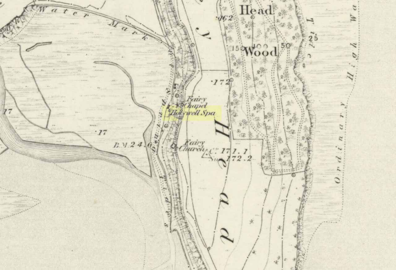
To get here you have to travel right to the end of the road, then walk a short distance until you hit the horrible coastal waters where there’s a natural rock arch. Just before here, on the west-facing side, is this famous holy well.
Archaeology & History
Just before this little-known sacred well is a cavity in the limestone rock which is called the Fairy Church, and a couple of hundred yards below here is another one which was known as the Fairy Chapel. This region was obviously of sacred importance to our ancestors – and should still be to those of us with ecological concerns. The waters from this well were said to cure poisons from the body. It was written about at some length in Mr Taylor’s (1906) superb survey, where he collated material from a series of other early tracts describing the well. He wrote:
“This celebrated medicinal well is said to have been used by lead miners from the time of the Romans. The patients come for a two or three days’ stay to “get the poison out of their systems.” The site is three and a half miles nearly due south from Cartmel. The water, which has a very peculiar taste, comes down from the hillside and flows into a small artificial basin or grotto. The key of the door is kept at a neighbouring farmhouse. Close to the well is an untenanted building formerly used by indigent sufferers. The wooded cliff forming ‘The Head’ is of singular beauty, overlooking the waters and sands of Morecambe Bay. On Hennet’s map of Lancashire (1828) the well is called ‘Spa Holy Well.’
“…Mr. W. O. Roper, in his Churches, Castles, and Ancient Halls of North Lancashire, writes: “One other appendage to the Priory of Cartmel should be mentioned, and that is the well known as the Holy Well. On the sea-shore, close under the towering cliffs of Humphrey Head, and almost immediately below the natural arch of rock which leads to the recess known as the Fairy Chapel, bubbles the well to which in former days the Priors journeyed in state from their neighbouring Priory, and to which in more recent times large numbers of people resorted, hoping to derive benefit from its medicinal qualities.”
“Mr. James Stockdale, in Annals of Cartmel, writes: “Near to this holy well (Humphrey Head) are two cavities in the mountain limestone rock called the ‘Fairy Church’ and the ‘Fairy Chapel,’ and about three hundred yards to the north there used to be another well, called ‘Pin Well’, into which in superstitious times it was thought indispensiable that all who sought healing by drinking the waters of the holy well should, on passing it, drop a pin; nor was this custom entirely given up till about the year 1804, when the Cartmel Commoners’ Enclosure Commissioners, on making a road to Rougham, covered up this ‘Pin Well’. I have myself long ago seen pins in this well, the offerings, no doubt, of the devotees of that day.”
“Mr. Hope, in his Holy Wells of England, says that “this is a brackish spring celebrated as a remedy for stone, gout, and cutaneous complaints. The water issues from a projecting rock of limestone, called Humphrey Head and its medicinal qualities occasion a considerable influx of company to Cartmel, Flookborough, Kent’s Bank and Grange during the summer months…”
Holy Well on 1851 map
The site was clearly marked in 1851 on the first OS-map of the area as the Holywell Spa, and the attendant Fairy Chapel and Fairy Church shown as two distinctly separate places, very close by.
References:
Hope, Robert Charles, Legendary Lore of the Holy Wells of England, Elliott Stock: London 1893.
Taylor, Henry, The Ancient Crosses and Holy Wells of Lancashire, Sherratt & Hughes: Manchester 1906.
To reach here, follow the same directions to get to the Apronful of Stones giant cairn. Walk on the footpath past the cairn for about 200 yards until you reach a large gap where the old walling has collapsed. Go through this and walk across the limestone rocks, towards the small rocky hillock rising up 100 hundred yards in front to your east (not the more rounded one to the north). That’s it!
Archaeology & History
This is a most intriguing find, and one to which I can find no other literary reference (though I aint checked Brayshaw’s Giggleswick). An undeniably large natural hillock has been modified and added to by people at some considerable time long ago and at some considerable effort! Measuring more than 47 yards (43m) roughly east-west, and 21 yards (19m) north-south, the most definable man-made remains here is the length of elliptical walling on the southern and western edges. The internal circumference of the enclosure measures roughly 113 yards (103m) all round the edges. The northern and eastern sides of the hill would appear to be mainly natural, but seem to have been modified a little — not unlike the mass of settlements and enclosures a few miles to the east, like Torlery Edge, Lantern Holes and others around Malham Moor and district.
The site needs professional assessment: first to ascertain its period (which seems Iron Age on first impression, but could be much later), and second to ascertain its nature. On the ridges close by we find a veritable mass of archaeological remains, ranging between Bronze Age to Medieval in nature. The giant Apronful of Stones is only 172 yards (158m) south; the Sheep Scar cairn circle 156 yards (143m) northwest; and one of the remaining Sheep Scar cairns only 58 yards (53m) away. And hopefully when we return to the place next week (fingers crossed!), we’ll be able to get some more photos of the walling you can see that define some edges of the site…
…to be continued…
References:
Brayshaw, Thomas & Robinson, Ralph M., A History of the Ancient Parish of Giggleswick, Halton & Co.: London 1932.
Legendary Stone (destroyed): OS Grid Reference – NT 058 865
Archaeology & History
Travelling along the old road between Crossford and towards Cairneyhill, on the right-hand (north) side, there was until recently a huge boulder, described by the folklorist J.E. Simpkins (1914),
“Its horizontal dimensions above ground are diagonally 18 feet by 21 feet; its vertical height above ground 5 feet… I estimate its weight at nearly 200 tons.”
The stone was proclaimed by 19th century geologists to be a glacial deposit from the upper region of the Forth (the nearest mountain region possessed of this type of stone); although our old petroglyph writer, Sir James Simpson, postulated the Witch’s Stone to be “of meteoric origin.”
But like oh so many old sites with heathen tales attached, the stone was destroyed by a local farmer on 7 February, 1972. The following interesting notes were made in a Crossford & Cairneyhill School log-book, describing its destruction:
“The local farmer blasted the “Witch’s Stone”, situated about 300m East of school at 2.30 this afternoon. Children vacated both buildings and sheltered at West End of main building. All windows were opened. Police informed that further operations of this nature will be carried out at weekend.”
A week later on February 14, all “remains of “Witch’s Stone” removed by blasting at 3pm today.”
On the other side of the road from our Witch’s Stone was another boulder, this time known as the Cadger’s Stone, said by Beveridge (1888) to have got its name,
“from the circumstance of its having formed a landmark for the ‘cadgers’, or itinerant merchants, who were wont to rest themselves and their ponies whilst they deposited for a short while their burdens on the stone.”
The earliest OS-map of the region in 1856 shows neither of these stones, but does highlight a Capel Stane, or Stone of the Horse, very close by.
Folklore
The stone was obviously of some traditional importance to local people in pre-christian times. David Beveridge (1888) described the position and creation myth of the Witch’s Stone as follows:
“On our right a singular-looking stone of blue limestone appears in a field, and is known as the Witch’s Stone, the popular legend being that a notable witch in this neighbourhood found it on the seashore, and that after she carried it some distance in her apron, the string of the latter broke, and the stone has since continued to lie in the place where it fell. “
A few years after this, the folklorist J.E. Simpkins (1914) wrote:
“The legend connected with this boulder is, that a witch wishing to bestow a valuable gift on the Pitfirrane family, resolved to present to them a cheese-press. With that view, she lifted this boulder and carried it some distance in her apron, but owing to its excessive weight the apron-strings broke and the stone fell to the ground, where it has remained ever since.”
If anyone knows anything more about this old stone, or has any old photos of the fella, please let us know!
References:
Beveridge, David, Between the Ochils and Forth, William Blackwood: Edinburgh 1888.
Simpkins, John Ewart, Examples of Printed Folk-lore Concerning Fife, with some Notes on Clackmannan and Kinross-shires, Sidgwick & Jackson: London 1914.
Liz Sykes, Saul and I wandered up to see this lovely spot a few years ago, to be found perched upon the top of the grassy boggy ridge a few hundred yards southeast of the Kerrycrusach houses (a coupla miles south of Rothesay, down the B881, on your left-hand [east] side). There are a few easy ways to get up here and it’s a nice amble, though you’ll get yer legs pretty wet if She’s been raining!
Archaeology & History
It was pouring with rain when I visited this small round tumulus with Liz, but a damn good view opened 360-degrees all round us when we hit the spot, the old tomb talking with others scattered on a select few hilltops from here: an obviously important ingredient to those who put it here. Mentioned only briefly in Marshall’s (1978) archaeological survey as being “seen on the skyline looking south from the West Road,” one side of the tomb had fallen away slightly, revealing numerous large pieces of quartz rocks in the construction: another obviously important ingredient (for whatever reason) to the doods who built it. The tomb, deemed as Bronze Age by Marshall, is about 3-4 feet high above the moorland and about forty feet across. Although this tomb officially sits alone here, it’s likely there are other sites close by that have yet to be found.
If little Saul (7 year-old at the time) wouldn’t have been all freezing and saturated and dying to get back home, I’d have sat on top of this old tomb for quite sometime. Twas a fine feeling: hills talking with hills, tombs with tombs, and a soaking-wet Paulus breathing the tranquility of it all.
References:
Marshall, Dorothy N., History of Bute, Bute Museum 1978.
Links:
RCAHMS: Kerrycrusach, Scoulag Moor, Bute – The archaeological info on this old tomb, from the hallowed database of the Royal Commission for Ancient & Historic Monuments, Scotland.