From the Cow & Calf car-park, walk towards and past the gigantic Calf rock, swerving round the fallen mass of rocks and into the trees at the back. Walk uphill to the Hanging Stones cup and ring stones, then keep heading—down the slope then back up the next one—west, for barely 100 yards until you’re on the level ground again, following the footpath alongside the heather. Barely 50 yards along, keep your eyes peeled in the heather for a low flat rock just a few yards in. Forage around and you’ll find it.
Archaeology & History
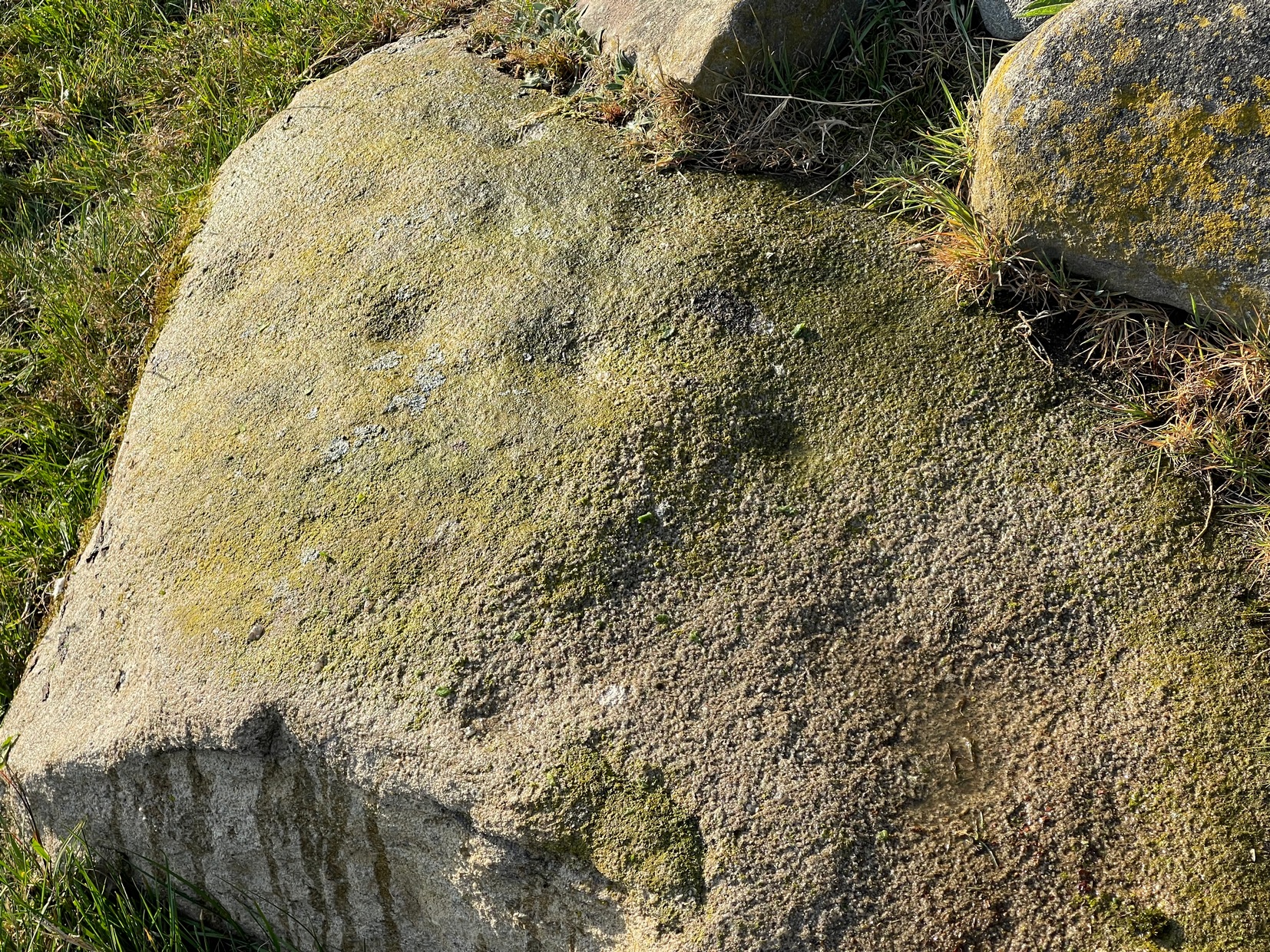
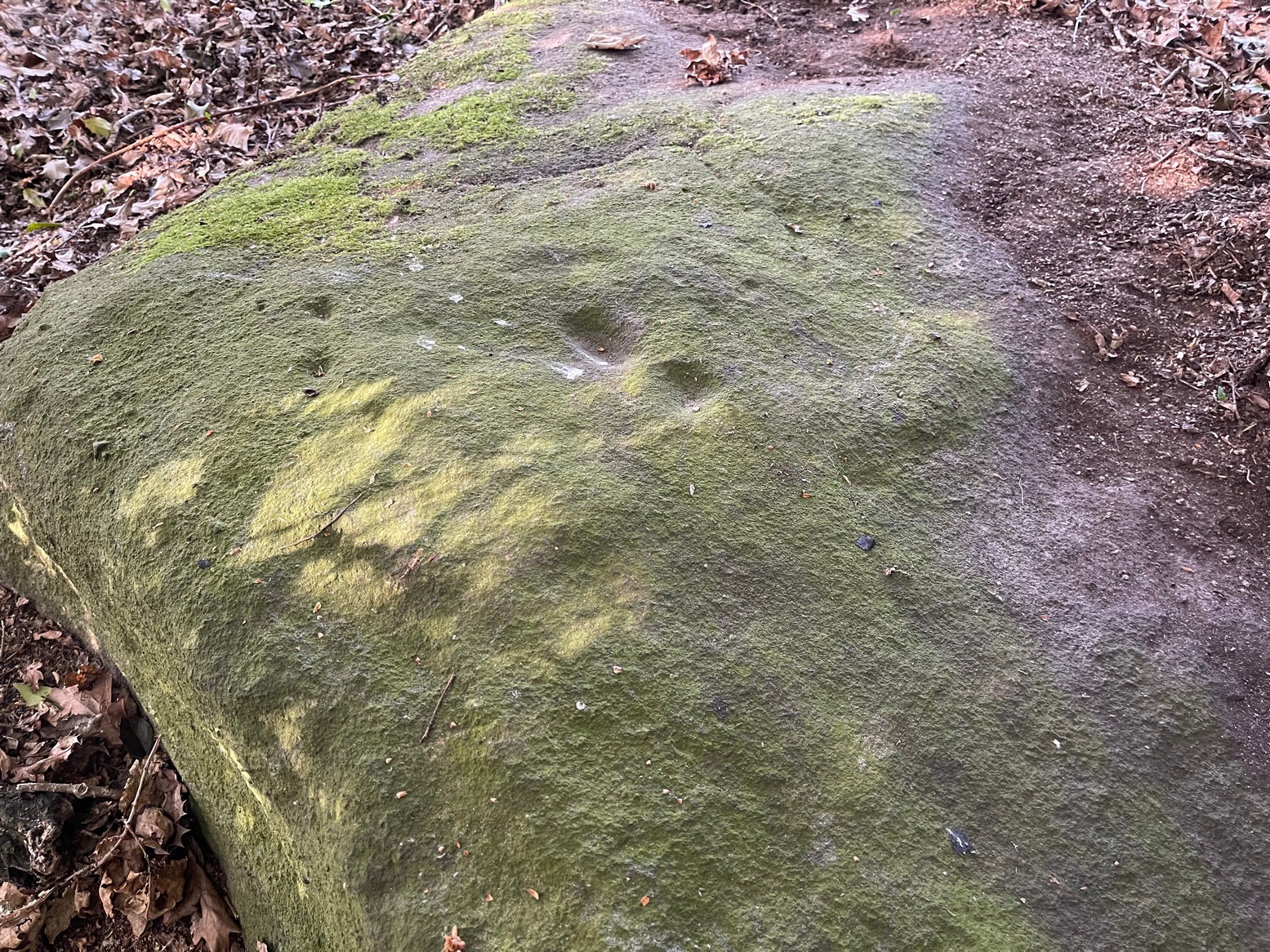
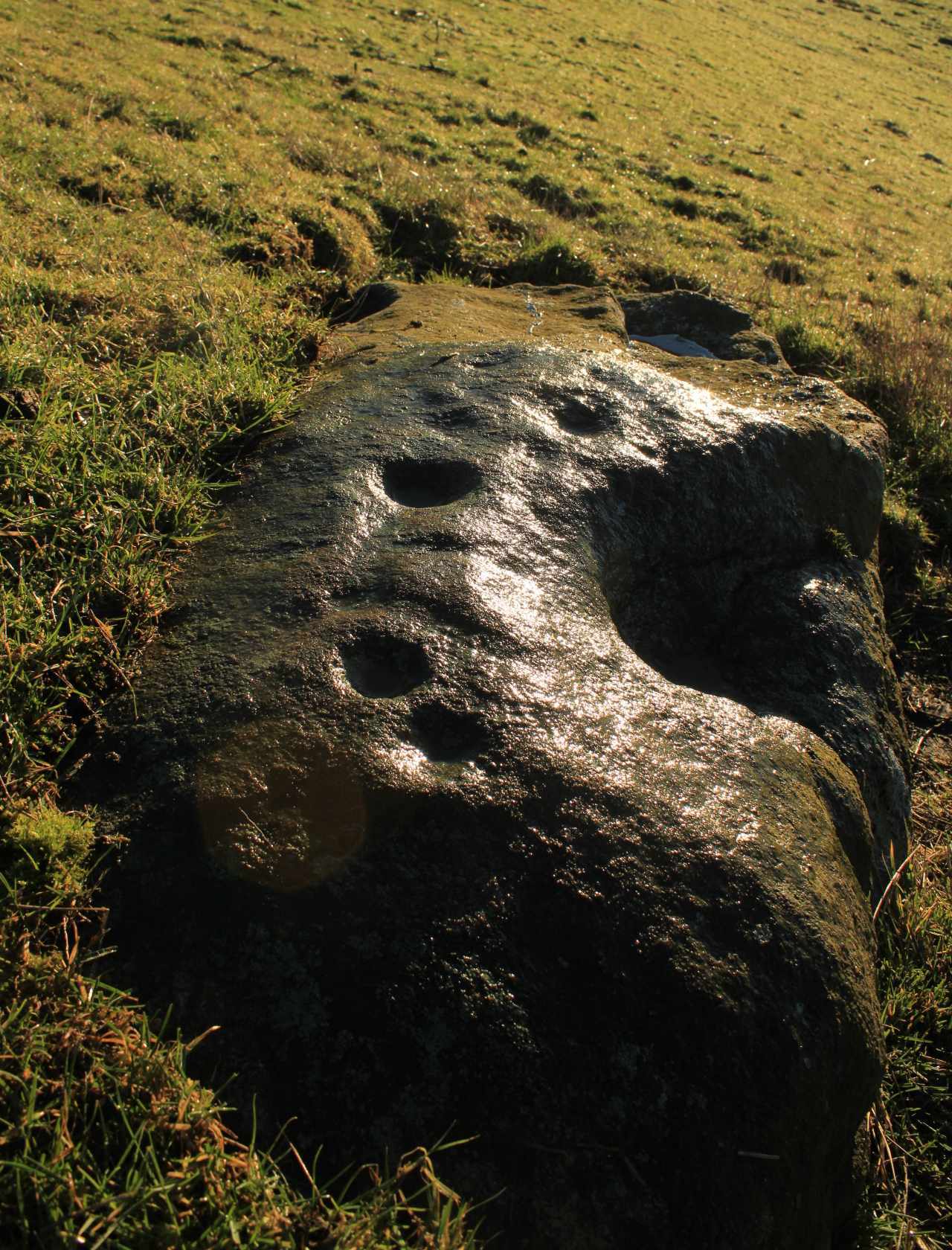
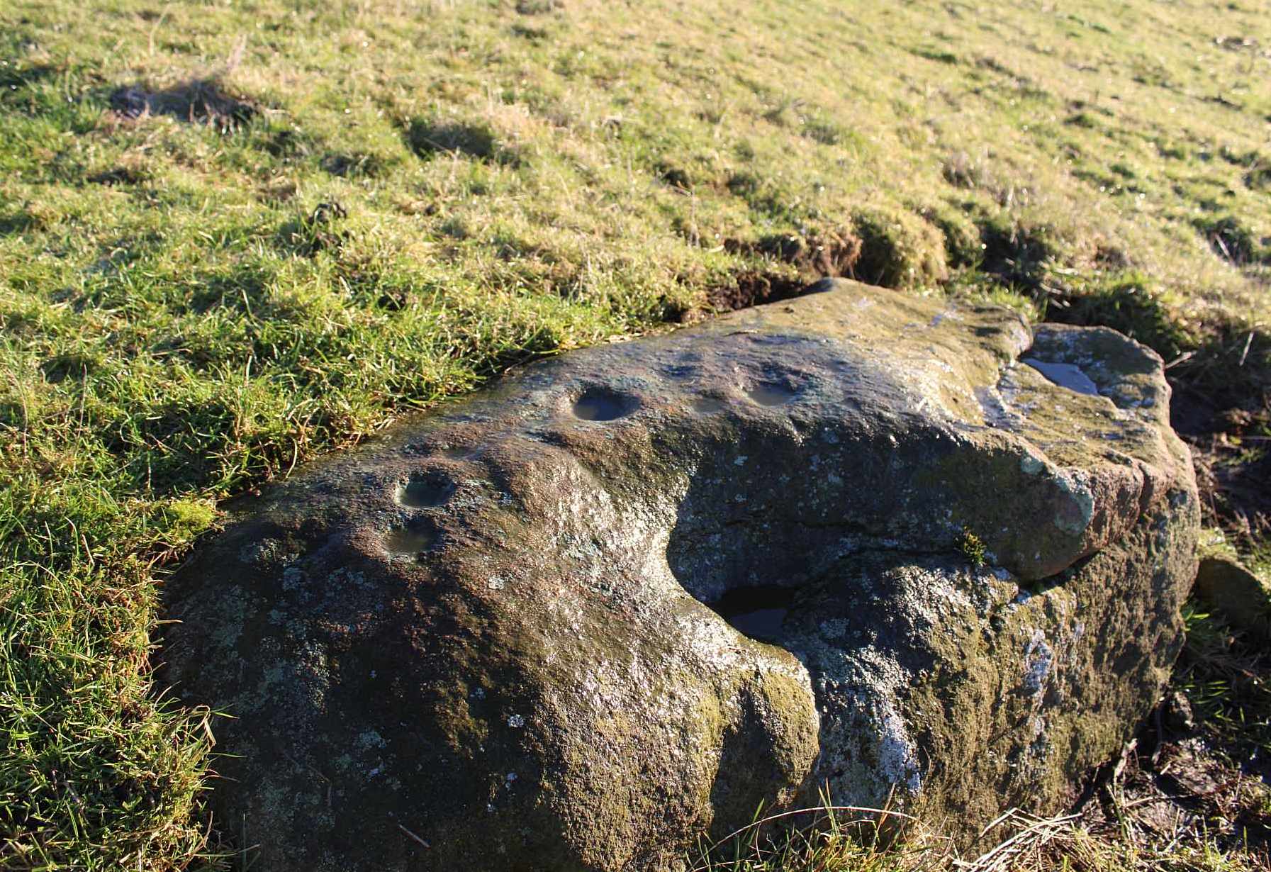
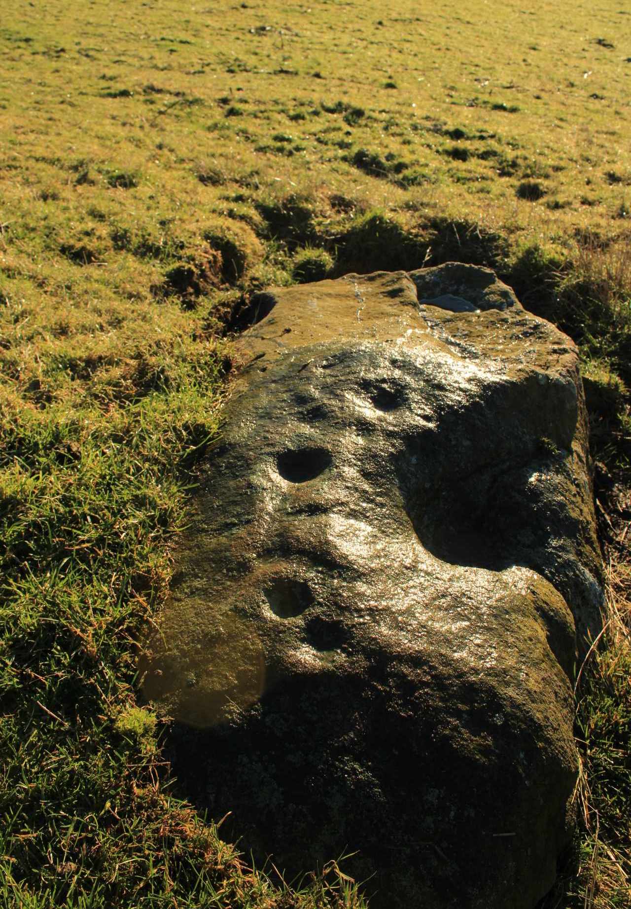
You’ll no doubt be seeing this carving after you’ve visited the impressive Hanging Stones petroglyphs 150 yards to the east. And you’ll probably be disappointed in its lack of visual grandeur when compared to its more ornate eastern neighbour. But the petroglyph fans among you should give it your attention.
Hedges 1986 sketchLooking to the SE
When the dawn or evening daylight cuts across the rock, the design looks much better than at sun high, perhaps telling us that the message of the stone coincided with those periods of the day. The gentle folds of the stone itself morph into the carving: evening and morning light cutting subtle shadowy folds across the rock, giving it an organic texture that our aboriginal ancestors told to be a vital essence of stone itself. The two small clusters of cup-marks upon this stone become greater than their basic design when brushed with the shadows and glows of a sunset. And when our aboriginal peoples painted them in ochre and other colours, an even greater mythos emerged—but sadly it is forgotten here….
When looked at with the simplistic eyes of the archaeo-mind, this and its compatriots are little more than a number of marks on lifeless rocks. This stone for example was described in John Hedges’ (1986) survey as being just “two groups of four and five cups and grooves”—nothing more—with naught but an echo in Boughey & Vickerman’s (2003) later work. The carving has neighbours even more basic in the heather close by…
References:
Boughey, Keith & Vickerman, E.A., Prehistoric Rock Art of the West Riding, WYAS: Wakefield 2003.
Hedges, John (ed.), The Carved Rocks on Rombalds Moor, WYMCC: Wakefield 1986.
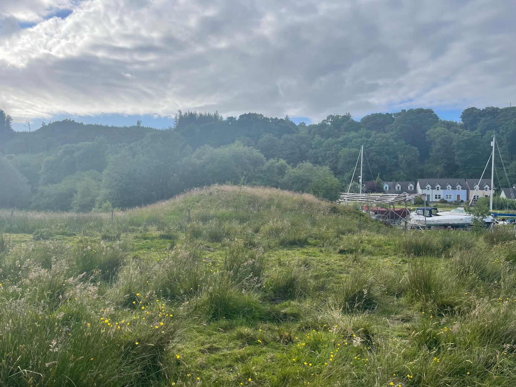
Take the A816 out of Lochgilphead and head north as if you’re going to Kilmartin. Nearly 2 miles along, take the left turn along the B841 Crinan road. A few hundred yards along, go over the canal bridge and about 70 yards along there’s a left turn onto the track into the Knapdale Forest. Go along here (there’s a parking spot) for 200 yards until your reach the grasslands on your left. If you walk into this bit of scrubland, you’ll see the rounded fairy-mound over the fence in the adjacent field, almost overlooking the canal. Y’ can’t really miss it.
Archaeology & History
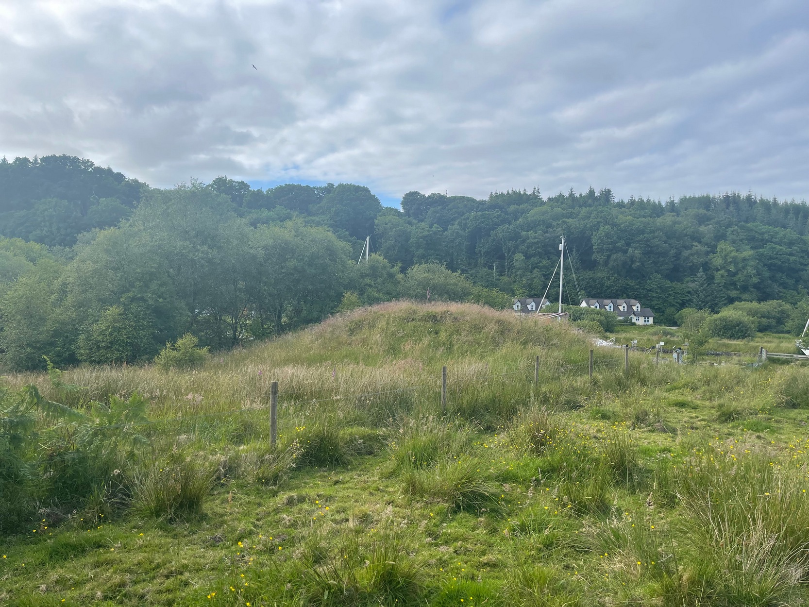
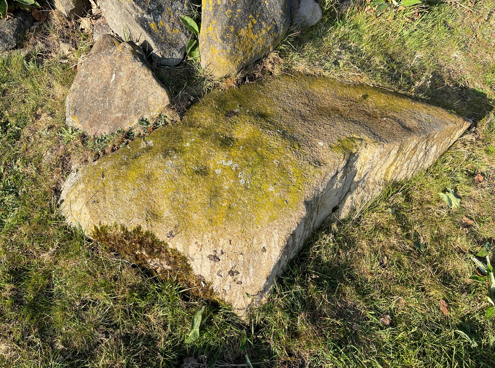
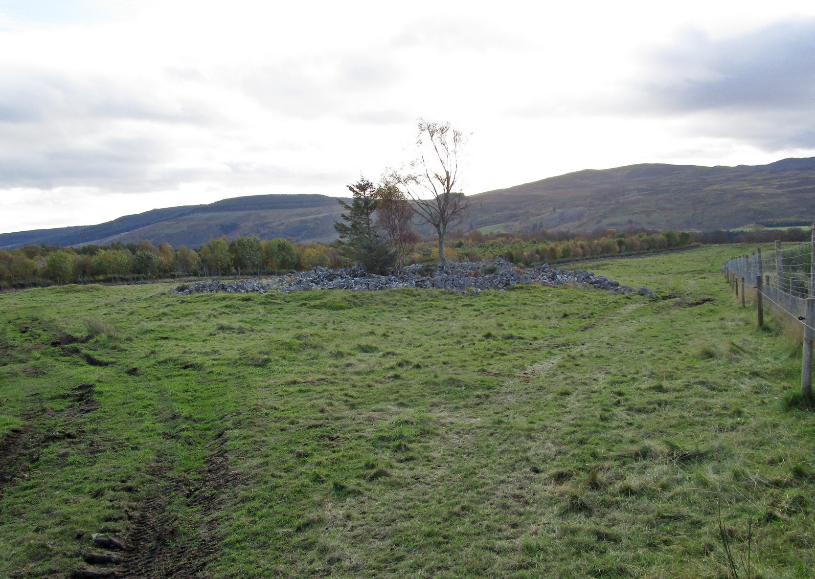
Carn ban, or the White Cairn, from which the hamlet of Cairnbaan gets its name, is a good-sized round cairn, now much overgrown in vegetation, though is still accessible and easy to see. Just above the water-line of the Crinan Canal, the mound is about ten yards across and more than six feet high and is in a good state of preservation. Originally, according to J.H. Craw (1930), the tomb was 12 feet high and 40 feet across!
Carn Ban on 1873 mapCarn Ban, looking NE
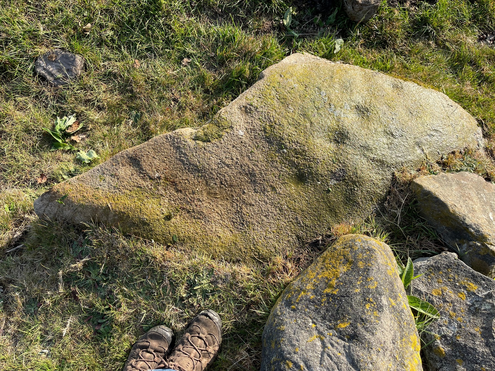
In the 1850s, the site was examined by a Dr Hunter of Lochgilphead, and Mr Richardson Smith of Achnaba, and a cist that had been built straight on top of the bare rock was uncovered near the centre of the cairn, nearly four feet long and aligned northeast to southwest. Inside it a thin slab of stone—“2 feet long, 17 inches broad, and 2½ inches thick”—had been slid up against the western end of the chamber and on it was a curious petroglyph design comprising “several incised diamond-shaped figures, one within the other”—five altogether, and the commencement of a sixth—similar to ones found at Newgrange in Ireland. This carving was removed and given to the Scottish National Museum where it still resides. Inside the cist, Hunter and Smith found a deposit of some “yellow sand with some black charcoal and several burnt bones lying upon its bottom”, and a subsequent search unearthed some flint fragments.
The Carn Ban is a good site—but if you’re wanting something bigger, something more impressive, I suggest heading just a few miles north…
References:
Beckensall, Stan, The Prehistoric Rock Art of Kilmartin, Kilmartin Trust: Kilmartin 2005.
Simpson, James, Archaic Sculpturings of Cups, Circles, etc., Upon Stones and Rocks in Scotland, England and other Countries, Edmonston & Douglas: Edinburgh 1867.
Acknowledgements:Huge thanks for use of the Ordnance Survey map in this site profile, reproduced with the kind permission of the National Library of Scotland.
In Hawksworth village, less than 100 yards past the primary school, take the footpath on your left into the open fields. 200 yards down the fields, go over the stile on your right, into the next field and walk diagonally across it (SW) for 250 yards until you reach the wall; then walk alongside it, west, for another 150 yards where the walling goes due south and walk down here for 135 yards, going through the gate at the bottom into the next field and, at the bottom of this one go through the gate and bear right. OK, now walk along the wall-side for 55 yards and you’re just about standing on it! Alternatively you can reach it via the Hawksworth Spring (1) and (4) carvings, following the wall along for roughly 150 yards till you reach the gate. Go through here and walk diagonally NNW across the field for nearly 150 yards where you’ll see the stone stuck out in front of the wall.
Archaeology & History
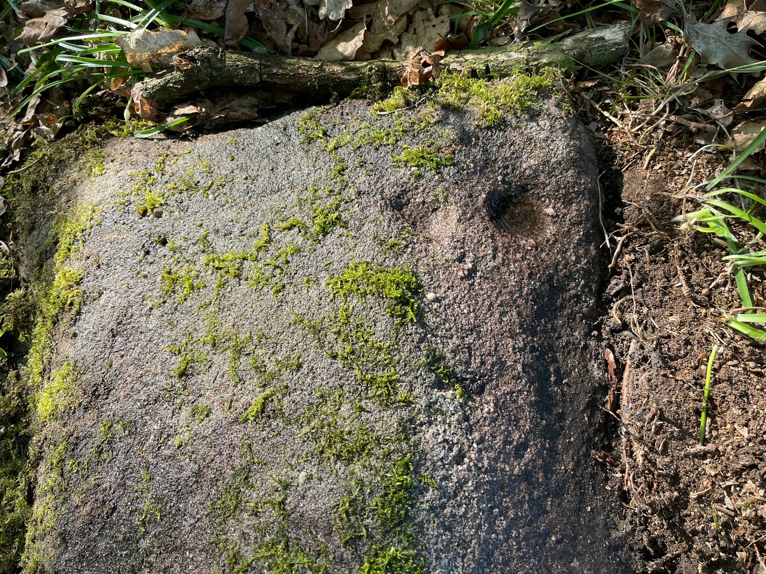
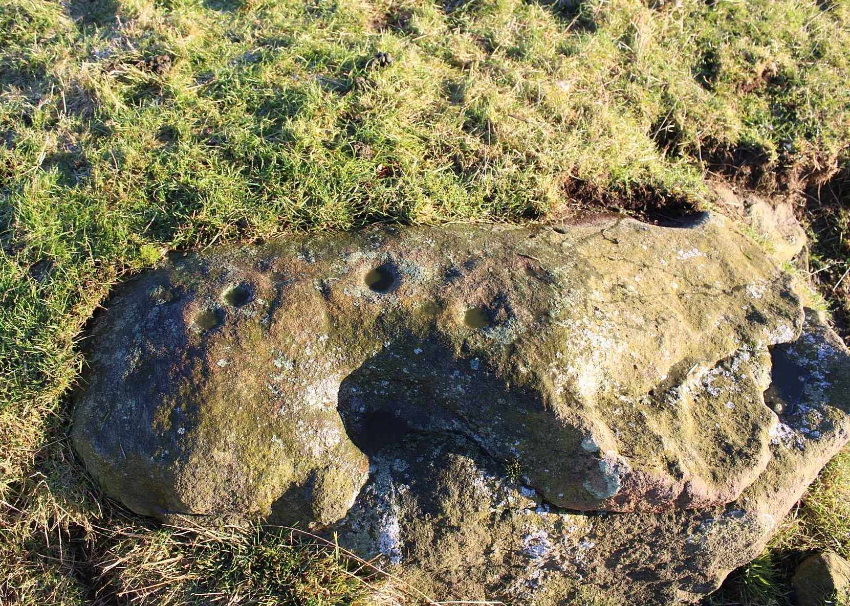
My first sight of this came about as I walked alongside the walling. Approaching the stone, I noticed what looked like a recent cup-like marking with a curved line emerging from it on its eastern surface; but it didn’t look too old and was more like the scratch-marks you see sometimes when farmers have been dragging rocks along to be used in walling. So I shrugged in slight disappointment—until the far-side, the western-side of the stone came into view.
Line of cupsMain scatter of cups
Sloping ever-so-slightly down into the ground, the surface of the stone had a cluster of quite worn, shallow, but distinct cup-markings between one and two inches across, four of which ran in a line from the top to the edge of the stone in a slight curve. As I walked round it, looking from different angles, it became obvious that two or three other cups existed—mainly from the top to the western side of the rock. One seemed to exist near the edge, whilst two other faint ones sat to the side of the line-of-four—almost creating a square formation. From some angles it looked as if there may be faint lines running between some of the cups but (as usual) the sunlight didn’t really help highlight them and they could just be faded erosion lines.
Looking down at the cupsWater & sunlight & cups
It was obvious that a section of the stone on its southern edge had been broken off in the not-too-distant past, raising the idea that the design may originally have been larger than its present form. This thought returned when I walked another 60 yards west along the wall and came across a broken section of stone that had been placed into it, pretty recently, and on its vertical face noticed a single cup-mark in a good state of preservation, indicating that it had either been cut recently or instead been dug out of the ground not too long ago and shown intself to the world after a sleep of several millenia. Look at it when you have a gander at the main carving here and make up your own mind….
Take the same directions as if you’re going to visit the Hawksworth Spring (1) carving. From here, the small footpath at its side keeps going uphill, curving to the right and following the line of walling. After about 20 yards where the land begins to level out, keep your eyes peeled for a small elongated earthfast rock, less than three feet long, just to the left of the path and only three or four yards away from the wall. If the leaves have covered the stone, get on your hands and knees and scrub around a bit. You’ll find it!
Archaeology & History
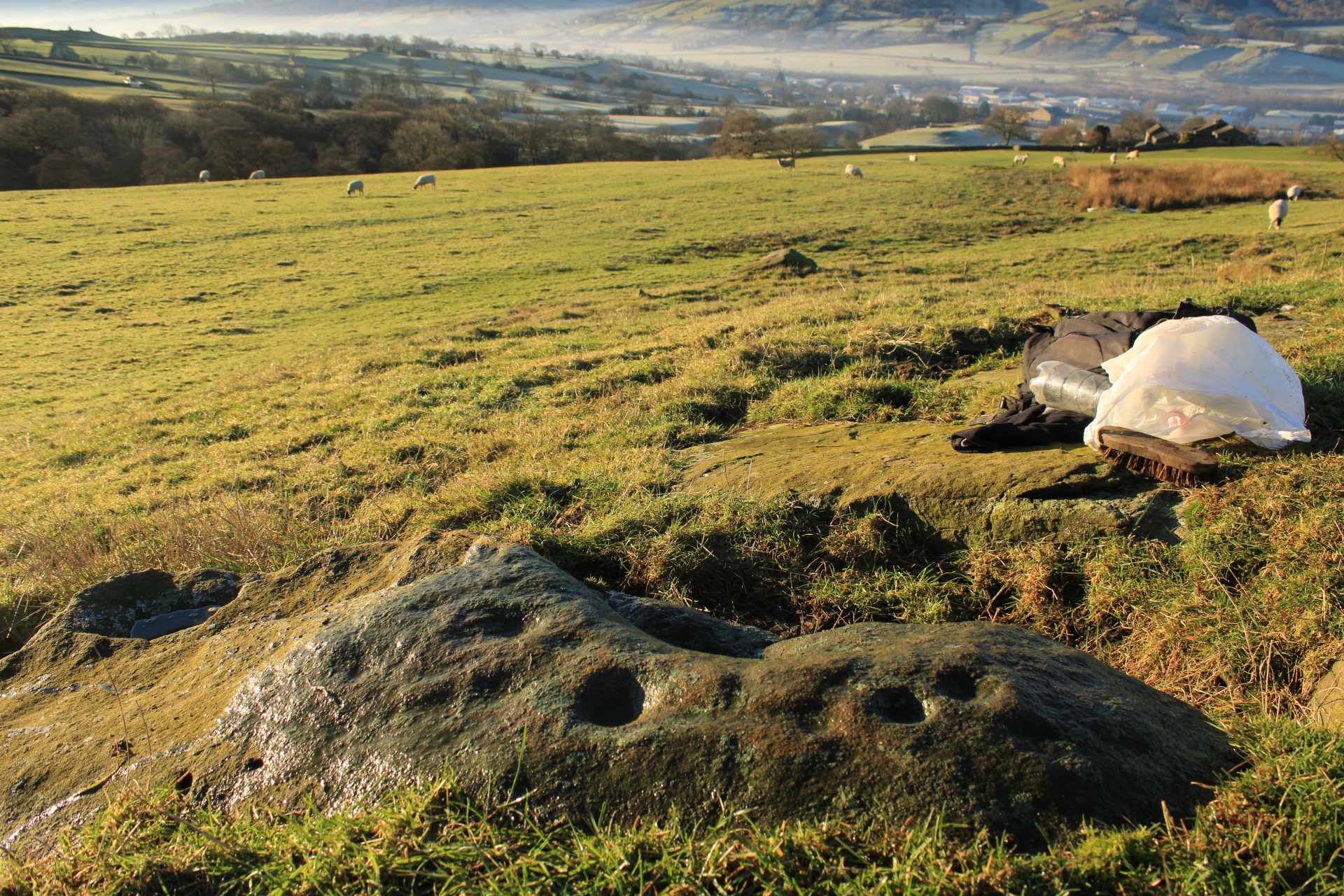
Primary cup-marking
This was a frustrating find as there are several elements on the stone, only one of which I could be 100% certain about – and that’s the singular cup-marking on the top-left of the stone. Just next to this is what looks to be another one, unfinished, cut into a natural fissure in the rock—but the daylight was frustrating, allowing only glimpses of visual clarity on the stone. At the other end of the stone, as the photo shows, are what stand out as two or three more cup-marks, but these seem geophysical in nature—although examples such as these scatter the works of Boughey & Vickerman (2003; 2018) as authentic, which shows the problem we all have as rock art students. Anyhow, at least one of these cups is the real deal. I’ll let the computer-tech lads sort the rest of it out for us…
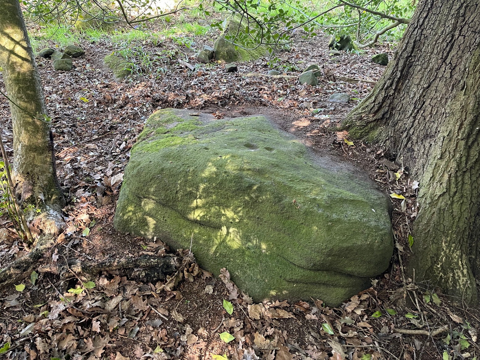
Once you’ve located the carvings of Hawksworth Spring (1) and (2), walk up the slope towards the topmost section of the walling where the land begins to level out. Hereby you’ll see the Hawksworth Spring (4) carving (if it’s not covered in leaves) several yards below the wall. Turn around and look diagonally to your left, into the trees, where you need to walk into and beneath the overhanging holly branches. Here you’ll reach the large earthfast rock whose edge rests up against the trunk of a larger tree. You can’t miss it!
Archaeology & History
Notable curious “cups”
I’m not 100% convinced that this a prehistoric design, despite it being listed as such in Boughey & Vickerman’s (2003) survey—although, to be fair, they do suggest it as being “doubtful.” The two most notable so-called “cups” have more of a recent hallmark to them and the other elements are troublesome to see with any certainty, but they may be geophysical in nature. Their description of it told us this was a “fairly large fine-grained rock with some included pebbles. Two pairs of cups, one pair connected by groove”. Make of it what you will….
References:
Boughey, Keith & Vickerman, E.A., Prehistoric Rock Art of the West Riding, WYAS: Wakefield 2003.
When the Grey Cairn above Balnabroich, Kirkmichael, was explored in the second-half of the 19th century by John Stuart (1865) and a number of local labourers, they found the floor of the tomb had been paved with a number of large boulders. Near its centre, along with finding remains of charred wood, they moved some of the rocks and,
“On turning over the stones a circular disc of stone with a hole in the centre was found, and also a small boulder with a cup on its flat face.”
Grey Cairn at sunfall
He made no further remarks about the carving and no intimation that it was removed, so we must presume it is still there, at the botton of the cairn. Any visitors to the site might want to have a look at the massive scatter of surface stones that make up the cairn to see if any further cup-marks exist on them. It’s not uncommon to find them on such giant tombs.
Folklore
A very curious folktale was known of the cairn in the 19th century, whose theme is recognized at numerous other prehistoric sites, but the mythic creature involved here is very much different from the ones we’re used to. Mr Stuart told that,
“The popular belief is that a mermaid is buried beneath it. This mermaid used to throw stones at people who were coming from church at Kirkmichael, and she could only be seen through a hole in the knot of the pine tree. At last she was chased to the hill at Balnabroch on her flight to the waters of Loch Marech, on the other side of the hill, and there killed, when the Grey Cairn was raised over her.”
References:
Royal Commission on the Ancient & Historical Monuments of Scotland, North-East Perth: An Archaeological Landscape, HMSO: Edinburgh 1990.
Stuart, John, “Account of Excavations in Groups of Cairns, Stone Circles and Hut Circles on Balnabroch, Parish of Kirkmichael, Perthshire,” in Proceedings Society Antiquaries, Scotland, volume 6, 1865.
Acknowledgements:Huge thanks for use of the Ordnance Survey map in this site profile, reproduced with the kind permission of the National Library of Scotland.
From near Skipton town centre, at the Cross Keys Inn along Otley Road, go up Short Bank Road all the way to the very top and then into the trees onto the Dales High Way footpath. Walk up for literally ¼-mile (0.4km) and where the path bends and heads ENE, notice here a footpath that takes you over the wall. Once on the other side, the path splits with one heading SE and the other roughly alongside the walling to the SW, which is where you need to go. About 200 yard on, go through the gate into the field and then another 375 yards on you’re into another field (copse of trees in front of you). Just as you’ve gone into this field, walk immediately left, uphill, by the walling for about 100 yards, over the marshy dip, then head into the field where, about 75 yards in, you’ll see some rocks scattered about…
Archaeology & History
Cleland Stone, looking S
In an area that’s had some considerable quarrying done to it, we’re lucky to find that this carving still exists. It was rediscovered by Thomas Cleland (hence its name!) in the summer of 2024. It consists of four distinct cups, with a possible fifth (and maybe more?) on its smooth elongated surface. The cups, as we can see, are quite deep and unmistakable. An incomplete ring seems to be around at least one of the cups; and there seems to be a carved straight line running between another two of them. A simple but distinct design and in a lovely setting gazing cross the Airedale valley from here.
There are very few other carvings in this neck o’ the woods (the Great Laithe Wood carving aint too far away), but the fact that this has been found would suggest that others are probably hiding away in the undergrowth. Check out the Iron Age Horse Close Hill enclosure while you’re up here too.
Acknowledgements: A huge thanks to Thomas Cleland, not only for finding the carving, but also for allowing use of his photos in this site profile.
Cup-and-Ring Stone: OS Grid Reference – NT 200 522
Also Known as:
La Mancha
Archaeology & History
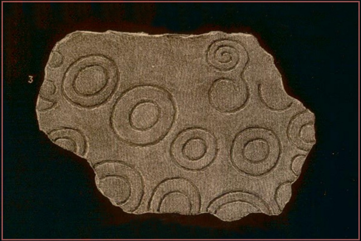
Simpson’s 1867 drawing
This is what I’ve come to term dyslexic cup-and-rings, due simply to the fact that it’s a cup-and-ring stone carving, but the cup in the centre hasn’t been carved out or pecked away. They’re rare – but for some odd reason, a small cluster of them occurs in this part of lowland Scotland. The Drumelzier carving 13 miles SSW is one; the Carnwath carving 14 miles west is another; 14 miles to the south, the multiple-ringed carving in the Woodend cairn had no defined pivotal cup; and in Childe & Taylor’s (1938) short piece on the Hawthornden petroglyphs near Roslyn (less than 10 miles northeast), they noted—like Simpson & Thawley (1972) years later—the peculiarity of “the complete absence of cups”, akin to Lamancha’s carved rings. (although we should be cautious about the archiac nature of the Hawthornden carvings)
The carving here was first mentioned by one of the great petroglyphic pioneers James Simpson (1866; 1867):
“A broken slab, about two feet square, covered with very rude double rings and a spiral circle, was found by Mr Mackintosh, at La Mancha, in Peeblesshire, in digging in a bank of gravel. There were some other large stones near it; none of them marked. Possibly this stone, therefore, is sepulchral in its character.”
Lamancha carving (G. & A. Ritchie, 1972 )
Eoin MacWhite (1946) was somewhat sceptical of Simpson’s “sepulchral” association, simply due to there being no account of a burial here. But in Simpson & Thawley’s (1972) survey of passage grave art, they thought the Lamancha carving was from “a possible cist slab.” We might never know for sure one way or the other.
The carving ended up living in Edinburgh’s National Museum where it should, hopefully, still be on display. As a result of this, it received the attention of the Royal Commission doods who gave a good description of the design in their Peeblesshire Inventory (1967). They state that it
“is irregular in shape and has maximum dimensions of 2ft 6in by 1ft 10in; it averages 4in in thickness. The markings, which have all been formed by the pecking technique, occur mainly on one face, the most common symbol being single or double rings. There are four complete double-ring symbols, in which the outer rings measure from 5in to 7in in diameter, and the inner rings from 2in to 4in. Round the margin of the face there are the broken arcs of five more double-ring symbols and of five single rings and one small V -shaped figure. As well as the ring markings there is a double-spiral, each lobe of which measures about 4in in diameter. In one lobe the spiral has two and a half turns and in the other only one turn. In addition, in a space which is otherwise free of markings, there is an area, about 4in square, heavily pitted with punch-marks measuring one-eighth of an inch across and one-sixteenth of an inch in depth. A remarkable feature of the stone is that three incomplete single ring symbols have been made on one edge. They have been formed by the same technique and measure 3in across; as in all the other symbols, the grooves themselves measure about half an inch in width and about one-eighth of an inch in depth.”
McWhite, Eoin, 1946 “A New View on Irish Bronze Age Rock-Scriblings”, in Journal Royal Society Antiquaries, Ireland, vol. 76, 1946.
Morris, Ronald W.B., “The Cup-and-Ring Marks and Similar Sculptures of South-West Scotland,” in Transactions of the Ancient Monuments Society, volume 14, 1967.
Morris, Ronald W.B., “The Cup-and-Ring and Similar Early Sculptures of Scotland; Part 2 – The Rest of Scotland except Kintyre,” in Transactions of the Ancient Monuments Society, volume 16, 1969.
Morris, Ronald W.B., The Prehistoric Rock Art of Southern Scotland, BAR: Oxford 1981.
Ritchie, Graham & Anna, Edinburgh and South-East Scotland, Heinnemann: London 1972.
Royal Commission on the Ancient & Historical Monuments, Scotland, Peeblesshire – volume 1, Aberdeen University Press 1967.
Simpson, D.D.A. & Thawley, J.E., “Single Grave Art in Britain,” in Scottish Archaeological Forum, no.4, 1972.
Simpson, J.Y., “On Ancient Sculpturings of Cups and Concentric Rings,” in Proceedings of the Society of Antiquaries, Scotland, volume 6, 1866.
Simpson, James, Archaic Sculpturings of Cups, Circles, etc., Upon Stones and Rocks in Scotland, England and other Countries, Edmonston & Douglas: Edinburgh 1867.
Cup-and-Ring Stone (destroyed): OS Grid Reference – V 838 896
Archaeology & History
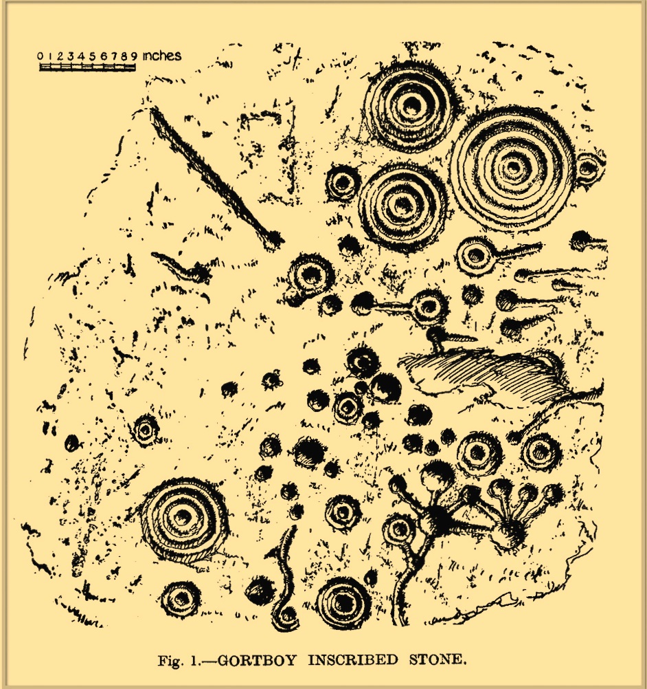
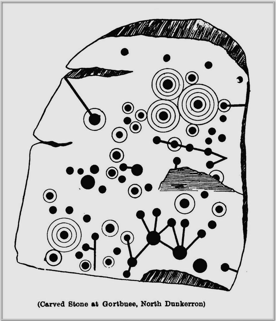
o’Connell’s 1939 sketch
In 1939 when D.B. o’ Connell wrote about this impressive cup-and-ring stone, he told that, with the exception of the Caherlehillan petroglyph (at V 569 837), this was “by far the most extensively decorated stone” that he’d seen in Kerry. He would therefore have been appalled to hear that it was subsequently destroyed in the 1950s and some remaining fragments of the stone “were used to line a well”! (o’ Sullivan & Sheehan 1996) Not good. There had already been an attempt to destroy the stone at the end of the 19th century, but that was prevented. Thankfully we had some early pioneer antiquarians who left us with information and sketches of this once great carving.
It was first described in John Cooke’s (1906) fine essay on the prehistoric antiquities scattering this part of Kerry. According to him, a certain “Dr. Digby is due the credit of having discovered this stone” a few years prior to him writing his essay. He told that:
Cooke’s 1906 sketch
“In one of the fields is a huge boulder, or rather earth-fast rock, somewhat rectangular in shape, of the purple grit of this district, and lying north and south. It measures 7 feet 8 inches long, 5 feet 8 inches broad at the south end, and 4 feet 6 inches at north end, the heights respectively being 2 feet 6 inches, and 2 feet 3 inches. A section from north to south would show a slight curve, as the rock is a few inches higher in the middle than at either end. The greater portion of this massive rock is covered with an extraordinary number of cup-markings, and cups with concentric circles. There are connecting channels everywhere, and the whole, though apparently intricate and unmeaning at first, yet shows, on examination, evidence of intention and design. It is much worn and weathered, and the north end has no markings. It is difficult to take a good rubbing of it, and still more difficult to sketch the markings, as the more it is examined, the more work does it show.”
This last comment applies to many petroglyphs. Mr Cooke continued:
“A peculiar feature of the ornament consists in the groups on the top left-hand corner, not unlike the tentacles and cupules of a cuttlefish. The dumb-bell-shaped ornament is found on other stones, but the truncheon-shaped figures on the right below are, I think, exceptional.”
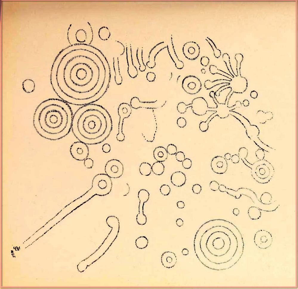
A discrepancy arose a few years later when Miss C. Hussey (1909) told how the carving had been discovered by a certain “Captain Magill, who some years afterwards saved it from destruction.” She told how,
“One day, when shooting in the neighbourhood, he saw some men breaking it with crowbars, etc., merely to clear the field of stones, and his daughter, who first showed it to me, said she believed that before he reached the spot, some four feet or more had been broken off the broader (south) end.”
So whether it was him or Dr Digby, we may never quite know. As for the design, Miss Hussey told us:
Miss Hussey’s sketch
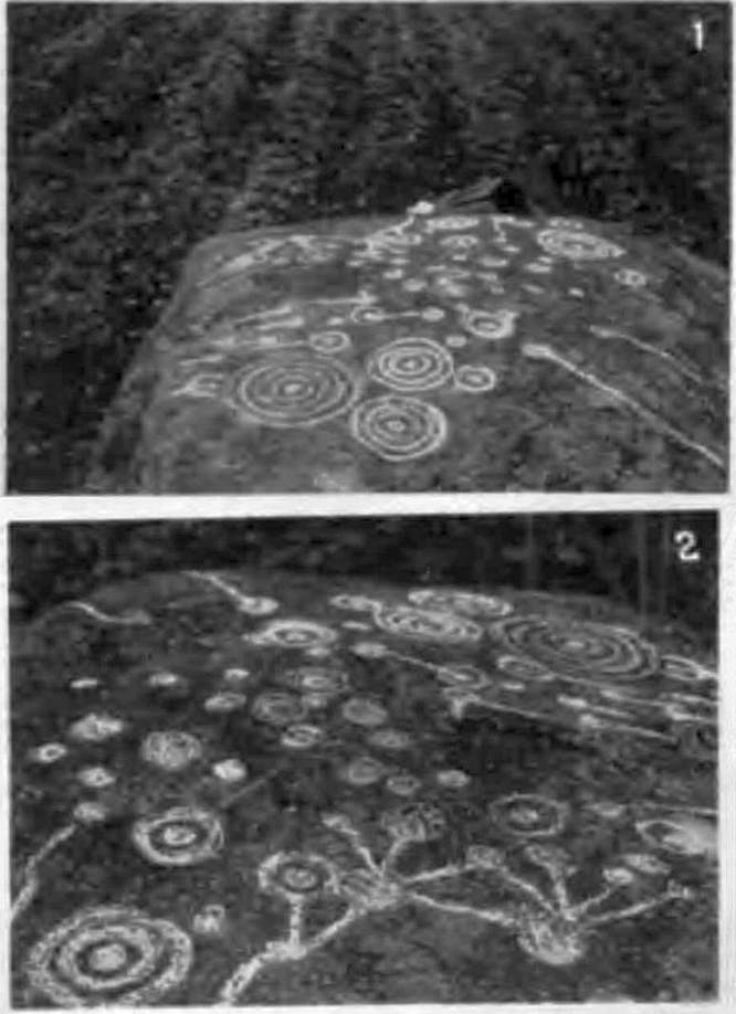
o’Connell’s 1939 photos
“The stone itself is a large block of sandstone, some four feet in height, and six feet wide. The entire length at present is nine feet, but the flat carved top only measures seven feet four inches in length, as the northern side slopes gradually instead of being upright like the others. The largest circle on the stone is twelve inches in diameter, and the cups and hollows vary in size down to about an inch across. It was difficult to be certain whether some hollows were cups or merely natural inequalities in the stone, but I have only given those which seemed to be unmistakably the work of man” in this sketch.
In o’ Connell’s (1939) description he echoed what our earlier writers had said, and thankfully gave us a couple of photos of the carving, highlighting the design in chalk so we could see it clearer. It’s such a pity that it’s no longer with us…
References:
Cooke, John, “Antiquarian Remains in the Beaufort District, County Kerry,” in Proceedings of Royal Irish Academy, volume 26, 1906.
Hadingham Evan, Ancient Carvings in Britain: A Mystery, Garnstone: London 1974.
Hussey, C., “Gortbuee Cup and Circle Stone,” in Kerry Archaeological Magazine, volume 1, 1909.
o’ Connell, D.B., “Notes on Three Inscribed Stones in County Kerry,” in Journal Cork Historical & Archaeological Society, volume 44, 1939.
o’ Sullivan, Ann & Sheehan, John, The Iveragh Peninsula: An Archaeological Survey of South Kerry, Cork University Press 1996.
Acknowledgements:Huge thanks for use of the Ordnance Survey map in this site profile, reproduced with the kind permission of the National Library of Scotland.
In o’ Sullivan & Sheehan’s (1996) magnum opus, they reported the discovery of a decent cup-and-ring stone “during road-widening operations in the 1970s,” a short distance west of the river Staigue. It was “seen to have rock art motifs on it, but it has since been covered over.” Its design was apparently similar to a complex carving at found Liss (V 608 617), just 300 yards or so to the south.
References:
o’ Sullivan, Ann & Sheehan, John, The Iveragh Peninsula: An Archaeological Survey of South Kerry, Cork University Press 1996.