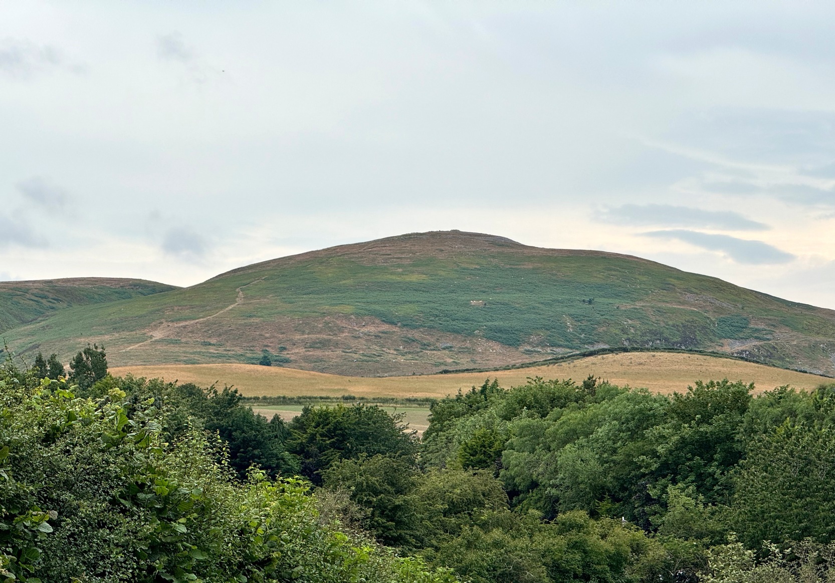
On our first visit to Wooler, in seeking out (and not finding!) a cup-and-ring stone alongside the old burn just on the northern side of town, we looked up at the ridged hillside of Humbleton Hill ahead of us and proclaimed, something along the lines of: “That look’s like something man-made up there!” And so it turned out. But the heat of the summer kept us from ascending the hill, so just an old account must be penned, from the quill of the great rock art pioneer George Tate (Home & Tate 1857) who, following a visit here in May 1852 with various members of the Berwickshire Natural History Society, penned the following:
“On the north side of Humbleton burn is a conical hill truncated at the top, and rising abruptly about 100 feet above the level of the burn; the slope, though considerable, is less steep on the other sides. This was one of the strongholds of the ancient Hritons. A rampier (now obliterated) ran around that part of the hill not protected by the ravine of the burn. The summit of the hill is 180 yards in circumference, having a hollow in the centre of the area; it is surrounded by a rampier of stone and earth, which is yet in some parts 3 feet high. This entrenchment is commonly called ‘The Cup and Saucer Camp’.”
The Hillfort itself is in very good condition overall, is very extensive and has a very clear series of walled ramparts all round the summit of the hill. It has yet to be excavated.
Folklore
The local folk-name given to this old hillfort—the Cup and Saucer Camp—related to the shape and lay-out of the enclosure, and with it, the tradition that the chiefs of the tribe inhabited the topmost enclosed section of the hillfort: the so-called ‘Cup’; whilst the tribal familes inhabited the realms immmediately outside and below the chief’s domain: the so-called surrounding ‘Saucer’. On the northern edges of the outer ‘saucer’ walls are several ‘hut circles’ (for want of a better term), that would house people, or their animals—or both.
References:
Home, Robert & Tate, G., “Address to the Members at the Anniversary Meeting, held at Embleton, Sept 8, 1852,” in Proceedings of the Berwickshire Naturalists’ Club, volume 3, 1857.
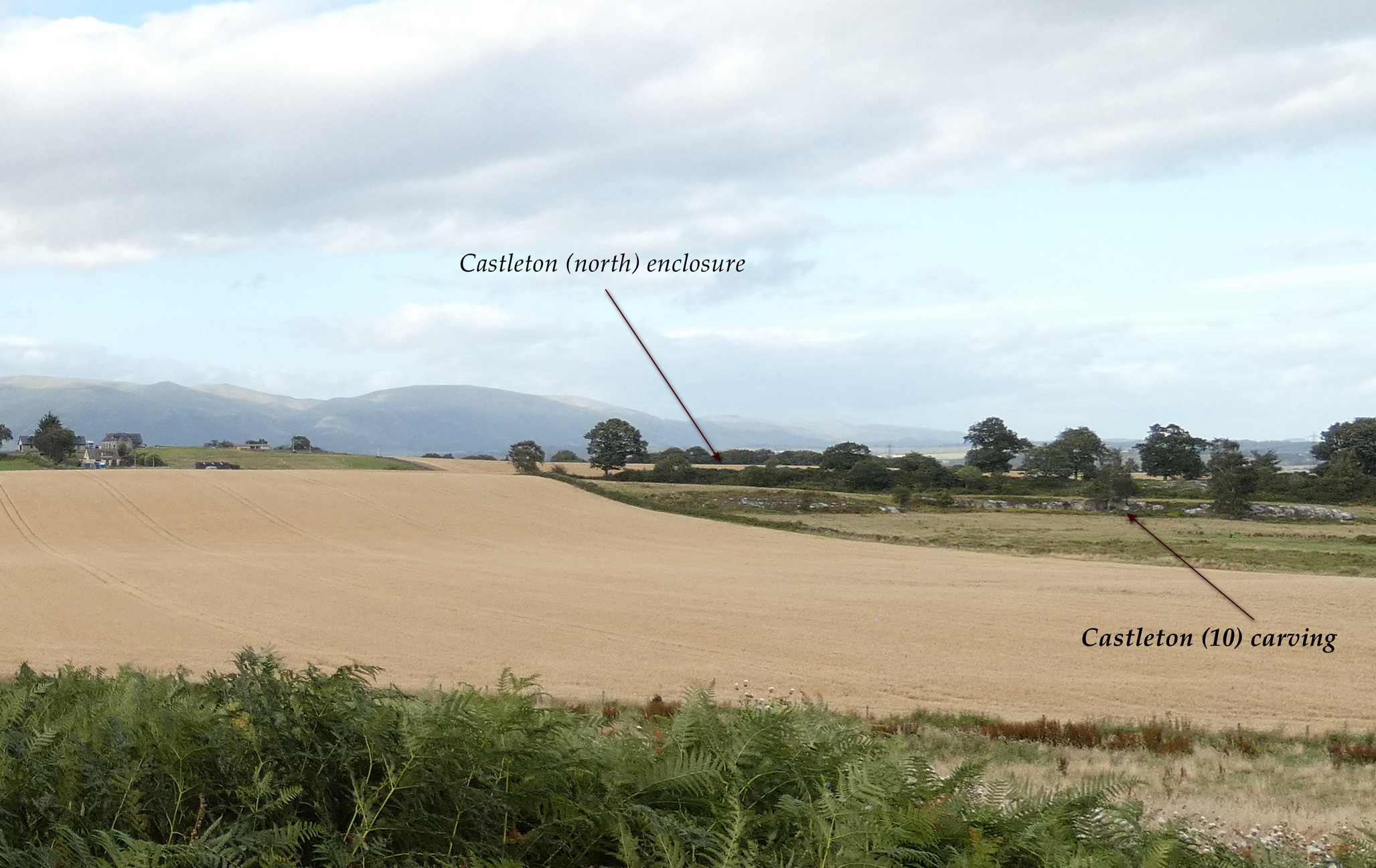
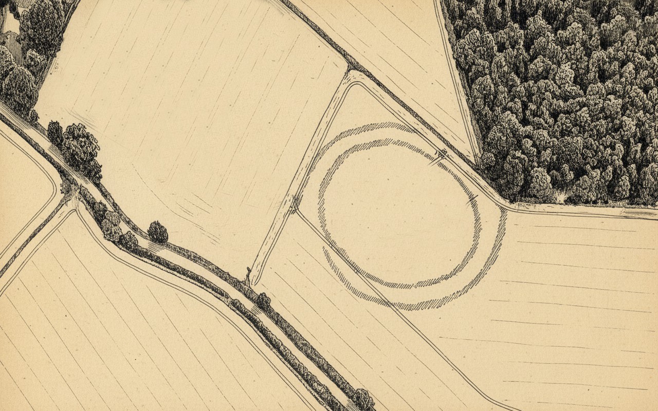
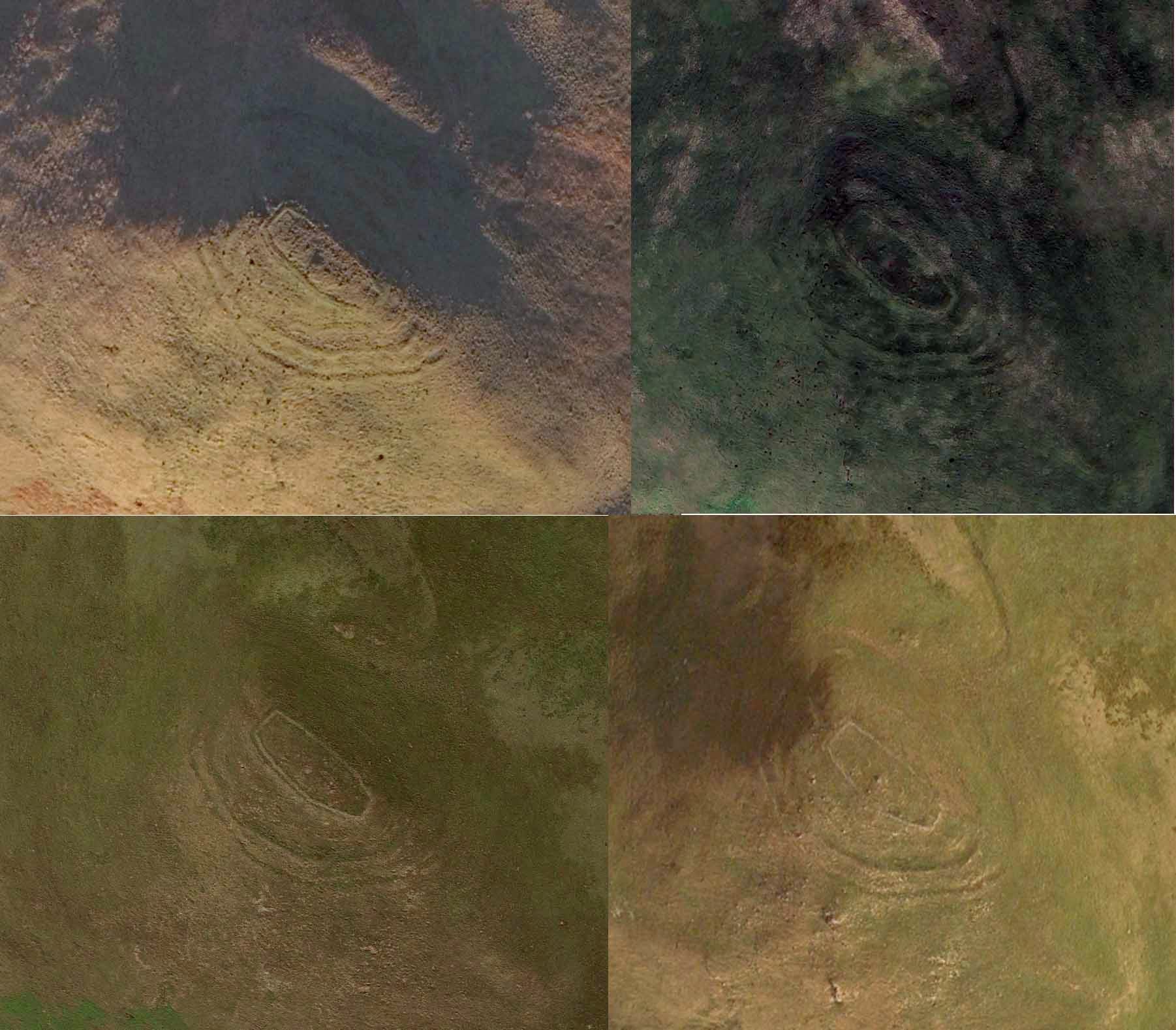
In the fields immediately above the northernmost of the Castleton petroglyphs, there was, in bygone times, a prehistoric settlement, forgotten and cast even from folk memory until very recently, when aerial photography revealed the ghostly outline of its former existence. Similar in design, but somewhat smaller than the prehistoric Gallamuir enclosure a half-mile southwest of the Castleton carvings, this double-ringed oval enclosure—thought by archaeologists to have been defined all round with large wooden stakes, or palisaded—measures, from outer edge to outer edge, 65 yards (SE to NW) across its longer axis, by 55 yards (SW to NE). The gap between the trenches that define the inner and outer wooden ‘walls’ is between five and six yards apart all round it. The entrance to the enclosure seems to have been on its southeastern side—although an excavation is needed to be sure about this. Sadly, almost nothing can be seen of the site at ground level. An archaeo-dig would be a good idea. 🙂
Rough sketch of site-plan
‘Palisade enclosures’ tend to be neolithic in origin and were in use for many centuries, sweeping into the Bronze Age. I highlight this long period in time due to the proximity of the extensive and very ornate cup-and-ring carvings that start just 300 yards southwest of the settlement on the first rock outcrop that you meet. It’s a good one too! Petroglyphs were also created mainly during the neolithic and Bronze Age periods; and as the enclosure here is on the slight rise in the land overlooking the various small rocky ridges below, many of which are decorated in ornate cup-and-rings, it’s likely that some of the people who lived here were probably the people who did them…
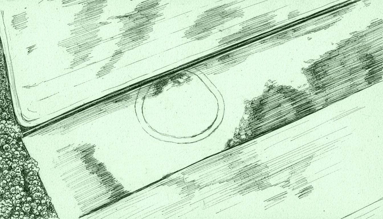
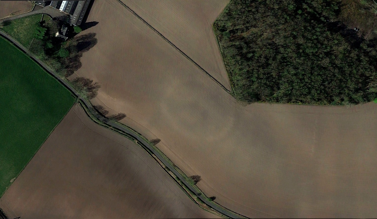
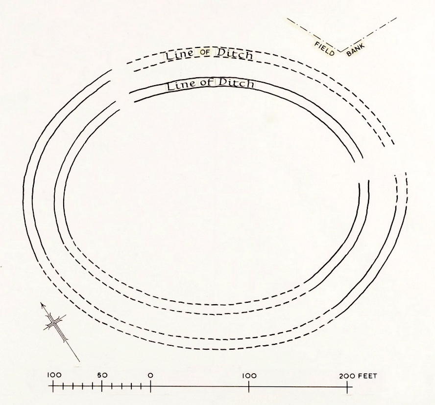
Just over a half-mile (1km) south-west of the major rock art complex at Castleton, in the fields just east of Gallamuir Farm on the north side of the B9124 road, could once be seen a decent double-ringed enclosure, prehistoric in nature. At ground level today there is nothing to be seen as agricultural practices have ever so slowly eroded it away. It wasn’t in a good state when the dudes from Royal Commission (1963) had a look at it in October, 1951—although they did tell us that some faint remnants were discernible, but it was fading fast! They wrote:
“No traces of this structure can normally be seen on the surface, but at the date of visit, when the site was covered with wheat stubble, stretches of both ditches were clearly visible, as shown on the plan (below), by reason of the stronger growth of the stubble overlying them. The ditches are from 20ft to 30ft apart, and the enclosed area measures 300ft from ESE to WNW, by about 240ft transversely. Two narrow gaps in the inner ditch on the north and east arcs respectively, may represent original entrances.”
Outline sketch of the enclosureRoyal Commission plan
Nothing remains of it today apart from the shadow-marks of its former existence when looked down from above. The double embankment that constituted the enclosure initially suggested it to be Iron Age in nature, akin to the larger hillforts up and down the country, but the outline is more consistent of a standard settlement enclosure. As far as I’m aware, no excavations have taken place here, so we’re at a loss to know whether the people living here had anything to do with the rock art just across the fields at Castleton. If we found that it had a Bronze Age or neolithic date, a connection could be likely. But we may have to look at the enclosure immediately north of the Castleton complex to be more sure of our petroglyphic culprits….
References:
Lock, Gary & Ralston, Ian, An Atlas of Hillforts of Great Britain and Ireland, Edinburgh University Press 2022.
Royal Commission on the Ancient & Historical Monuments Scotland, Stirling – volume 2, HMSO: Edinburgh 1963.
Royal Commission on the Ancient & Historical Monuments of Scotland, Archaeological Sites and Monuments of Stirling District, Central Region, Society of Antiquaries of Scotland 1979.
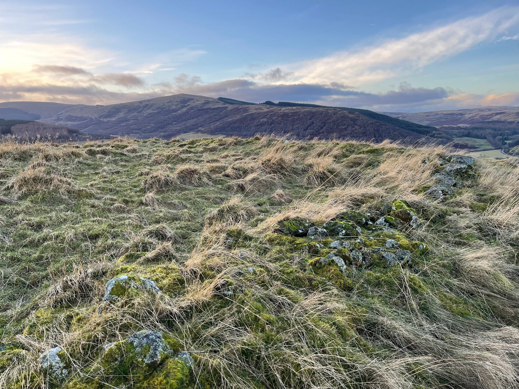
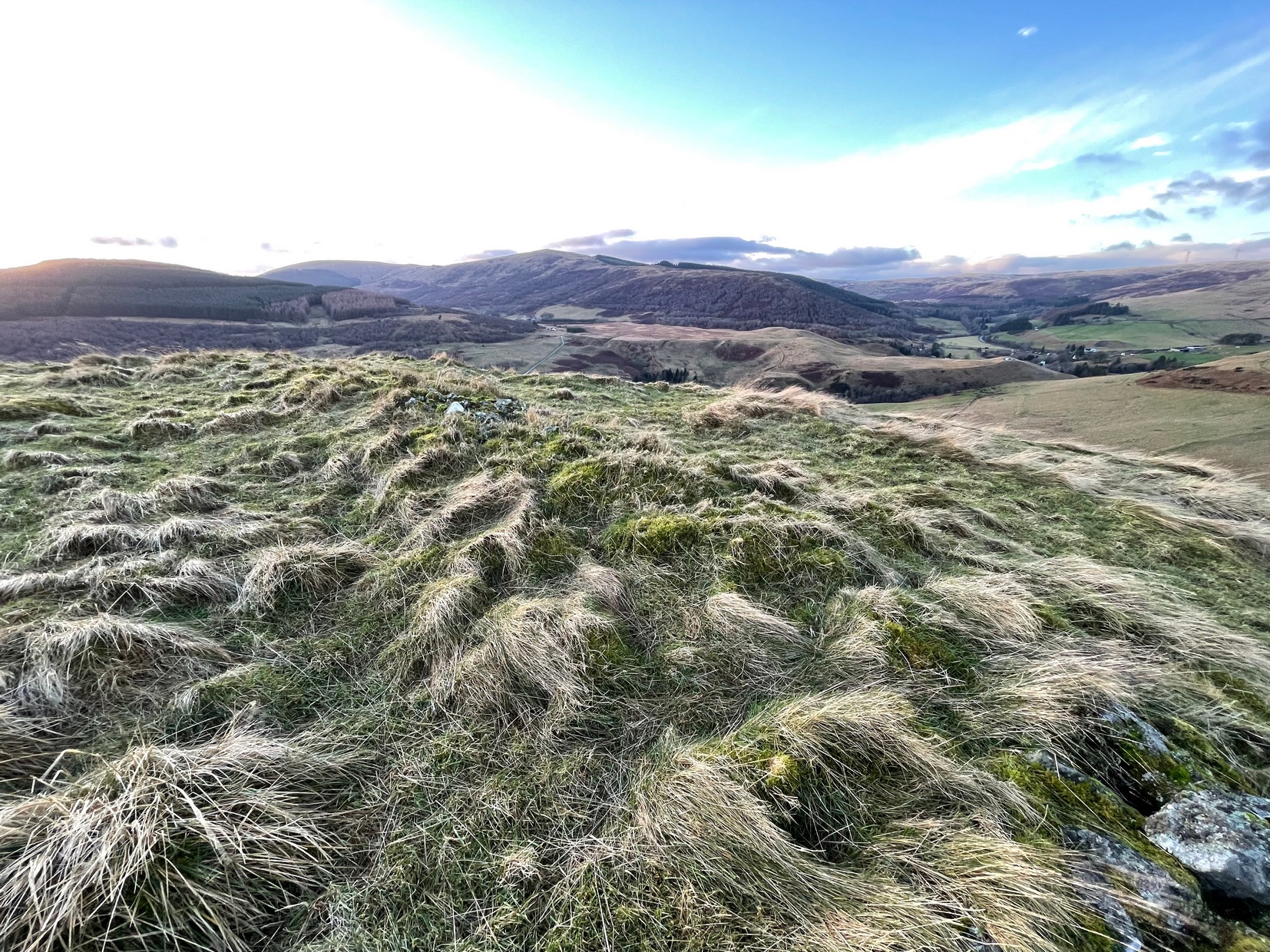
Travelling north along the A823 Glendevon road (between Muckhart and Gleneagles), barely 2 miles after Muckhart, on your right you’ll see the large Castlehill reservoir. Park here. Across the waters is the large Down Hill—which the hillfort crowns. So, just walk back the way you came along the road for nearly 600 yards and then turn left to walk onto the other side of the water, round to the very end of the track and then up the path into the trees. Walk along this winding path for 300 yards until you reach the track that takes you (left) up to Downhill Farm. One way or the other, past there, just stagger up to the top of the hill!
Archaeology & History
SW wall from rampart
My only visit here was a short one – when some pretty awesome freezing gales were nearly throwing me off the top once I’d got up there! Twas incredible! On my way to the top, nearly there, on its western side, I stopped and looked each side of me as it looked as if a long overgrown line of embankments was running roughly north-south. It seemed very vague and hillforts aren’t my subject, so with the help of the wind throwing me everywhere, I made my my final zoom to the summit, only to be intruded upon again, perhaps 50 feet from the top by another similar-looking embanked ridge—this time with some stones along it and which I was pretty sure were earthworks, or ramparts as they’re known. And so it turned out to be.
Once on top, the views are superb! But I couldn’t really take it in on my short visit here as the freezing wind was truly incredible and I could barely stand upright. And so I briskly followed to the quite notable stone-walled edges of the main prehistoric “enclosure” and walked round the edges as best I could, hoping that at least one or two of the photos I was taking weren’t too blurred.
Views from aboveSW wall & central structure
The interal “settlement” portion of the hillfort is quite large, obviously, allowing for a good number of people to live here (regardless of the wind!). It’s roughly oblong in shape, aligning northwest to southeast, measuring in length a maximum of 78 yards from outer wall to outer wall, with a maximum width of 30 yards (SW to NE). The collapsed walling is still quite extensive and visible above the long grasses almost all the way round the entire structure, averaging one or two yards across. Near the centre of the fortress is a large pile of stones that seemed to have been a structure of some kind, but when i was here I didn’t hang around for too long to inspect it as I was, by now, bloody freezing! It didn’t seem to be a walker’s cairn, but we need another gander to work out what it might have been.
Northern arc of wallingNW line of walling
Curiously this site has had little said about it in archaeo-tomes and to my knowledge, no excavations have happened here. Incredibly, the place wasn’t even recognised as a prehistoric site in official records until the Royal Commission (1963) told of it being “discovered during the survey of marginal lands (1956-58)”! Its very name derives from the word dun, or fort (Watson 1995) and as the place-name writer found out, it was first mentioned in 1542, as Donehill, and many times thereafter in various documents.
Anyhow—check the place out. It’s mightily impressive and the views from the top are excellent. Just avoiding going up there in a freezing gale!
References:
Hogg, A.H.A., British Hill-Forts: An Index, BAR: Oxford 1979.
Royal Commission on the Ancient & Historical Monuments Scotland, Stirlingshire – volume 1, HMSO: Edinburgh 1963.
Watson, Angus, The Ochils: Placenames, History, Tradition, PKDC: Perth 1995.
Acknowledgements:Huge thanks for use of the Ordnance Survey map in this site profile, reproduced with the kind permission of the National Library of Scotland.
Cup-Marked Stone (lost): OS Grid Reference – NO 262 503
Archaeology & History
In an excursion to the Iron Age Hillfort on Barry Hill in the early 1960s by some members of the Perthshire Society of Natural Science, near the very top on its southwestern side they discovered “a small cup marked stone.” (Longworth 1962) It hasn’t been seen since. And whether it was in the walling of the fort, or was a carved earthfast rock, they neglected to tell. When I visited here several years ago I couldn’t find the damn thing and presume that it’s simply been overgrown by the vegetation. In the event that you manage to rediscover the carving, see if you can catch us a good photo or two and stick ’em on our Facebook group.
References:
Longworth, Ian, “Dundee, Angus,” in Discovery & Excavation, Scotland, 1962.
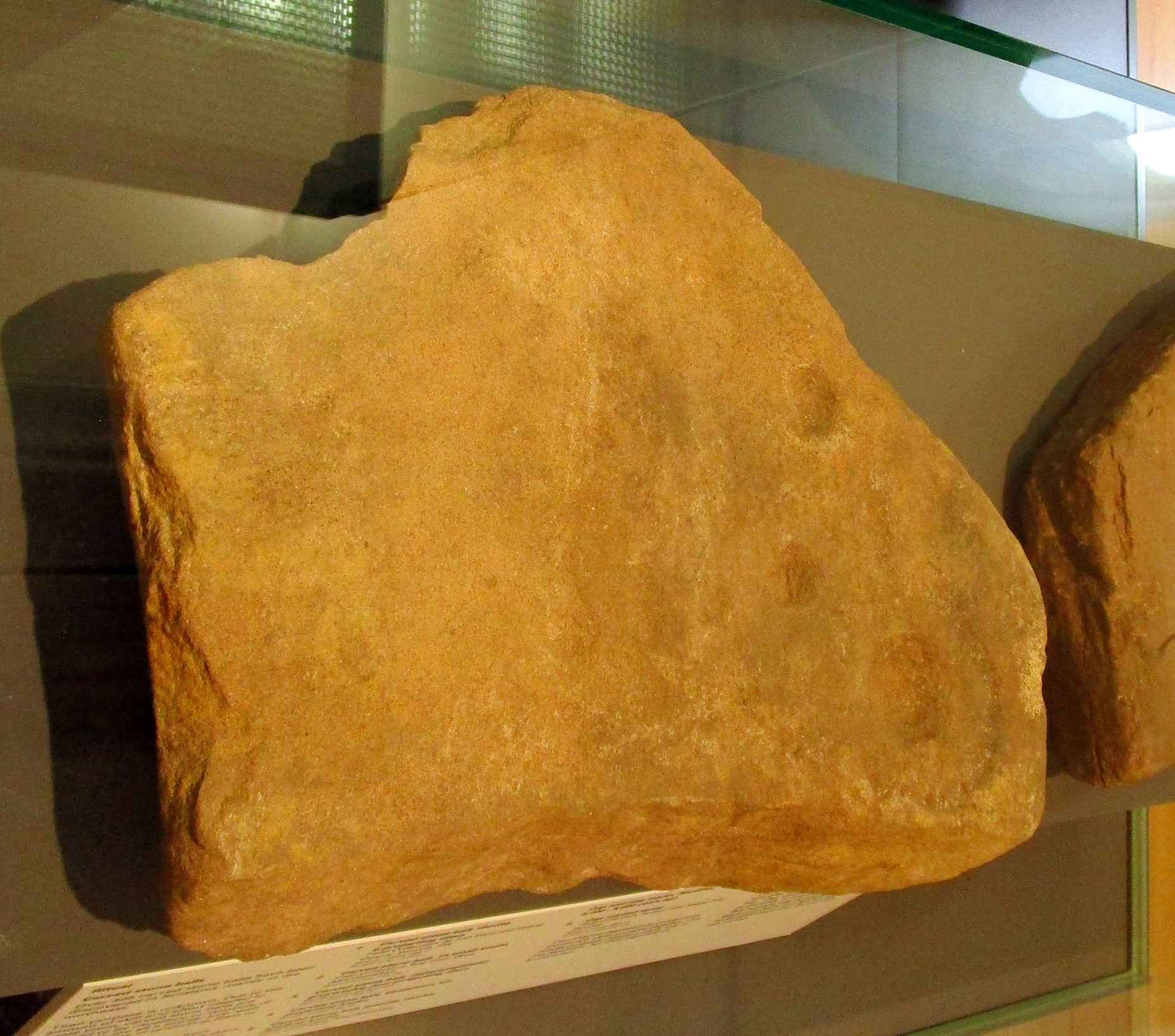
Cup-and-Ring Stone (removed): OS Grid Reference – NO 378 308
Archaeology & History
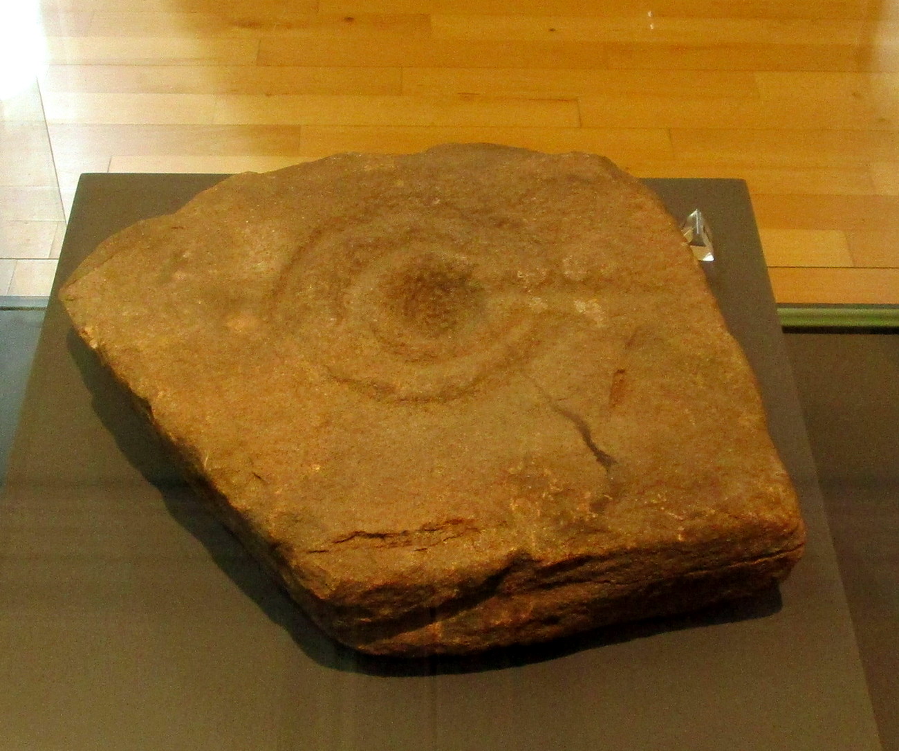
Cup & ring stone of Balgay Hill
This little-known cup-and ring stone was found at ground level sometime around 2003, near the top of Balgay Hill. A small portable stone that may have been broken from a larger slab, it has what seems to be two if not three cup-and-rings, accompanied by two or three single cup-marks. One of the rings seems to have a faint line coming out of it. Unfortunately none of this is clear in the photos I took (the one attached here is the best), as it lives under glass in Dundee Museum, so it was very difficult to get decent images. It is now housed in the McManus Museum in Dundee (a damn good place, with very helpful staff) and well worth checking out if you’re in the area.
Cup-and-Ring Stone (removed): OS Grid Reference – NO 5061 5565
Archaeology & History
Finavon carving, now in Dundee Museum
Close to the western walls of the Finavon Iron Age hillfort this small (portable?) cup-and-ring stone was found at ground level in 1987. It was probably knowingly reused in the construction of the hillfort, but whether it was just deemed as an innocuous carving thrown into the mass, or whether it held a place of importance cannot be known.
The primary design consists of a cupmark surrounded by a double-ring, with a line coming out of the central cup towards the edge of the stone. The stone itself—measuring 12 inch by around 10 inch—has been cut from a larger piece, meaning the original design may have been larger. It is now housed in the McManus Museum in Dundee (a damn good place, with very helpful staff).
Cup-Marked Stone (lost): OS Grid Reference – NT 179 356
Archaeology & History
In Sir George Douglas’ (1899) brief sketch of prehistoric remains in Peeeblesshire, he described coming across a petroglyph somewhere near the top of the Iron Age hillfort east of Stobo Castle, near Drumelzier (King Arthur country). He told that,
“on a flat stone lying on the slope of the fort at Lour, are two “cups,” measuring 2¾ inches in diameter and an inch in depth, and exhibiting perfect symmetry in their form and position on the stone: they have been thought to be genuine examples of “rock-markings”.”
The carving hasn’t been seen since and it’s presumed that vegetation has covered the stone. (the grid-reference for this site is an approximation)
From Kirriemuir town centre up the B956 Kinnordy Road, turn left where it goes along the B955 road for several miles towards Cortachy. Keep going on the B955 for a few more miles into Glen Clova, past the Caddam stone and eventually, after going over the bridge into Clova village, you turn left and go up towards the mountains. Nearly 3 miles along you see the very conspicuous and impressive rising crag, like a small volcano on the right-hand side of the road, which is Dun Mor. Walk up the steep climb round to the back of it – and you’re in the middle of the old ruins…
Archaeology & History
Highlighted on the 1865 OS map of the region, Dun Mor is Gaelic for a “large or great fort” – and such it is! Those of you with a nose for these sorts o’ things will no doubt take to the remains pretty quickly. Its position in the landscape is a bit of a gem! On its north-side— invisible to anyone in the glen below—an overgrown arc of walling some 3 feet high and about 70 yards long bends towards the crag of rocks on each side, with a notable “dip” or entrance about 8 feet wide in the middle of it. The walling itself averages about 4 yards wide all along its arc.
The crag of Dun Mor
It’s quite impressive once you get a good feel of the place and envisage it as it once was. The sheltered fortress within the rise of Nature’s crags is about 100 yards across and would be ample space for several families to live in when it was first built, in those mythic times of so so long ago. It was probably constructed in the Iron Age, although several ruined rectangular stone structures inside it are thought to be mediaeval shelters; and even in those more recent times, the people here would have regularly heard the howl of the wolves, whose names are kept in the hills above as reminders of a world not too long past….
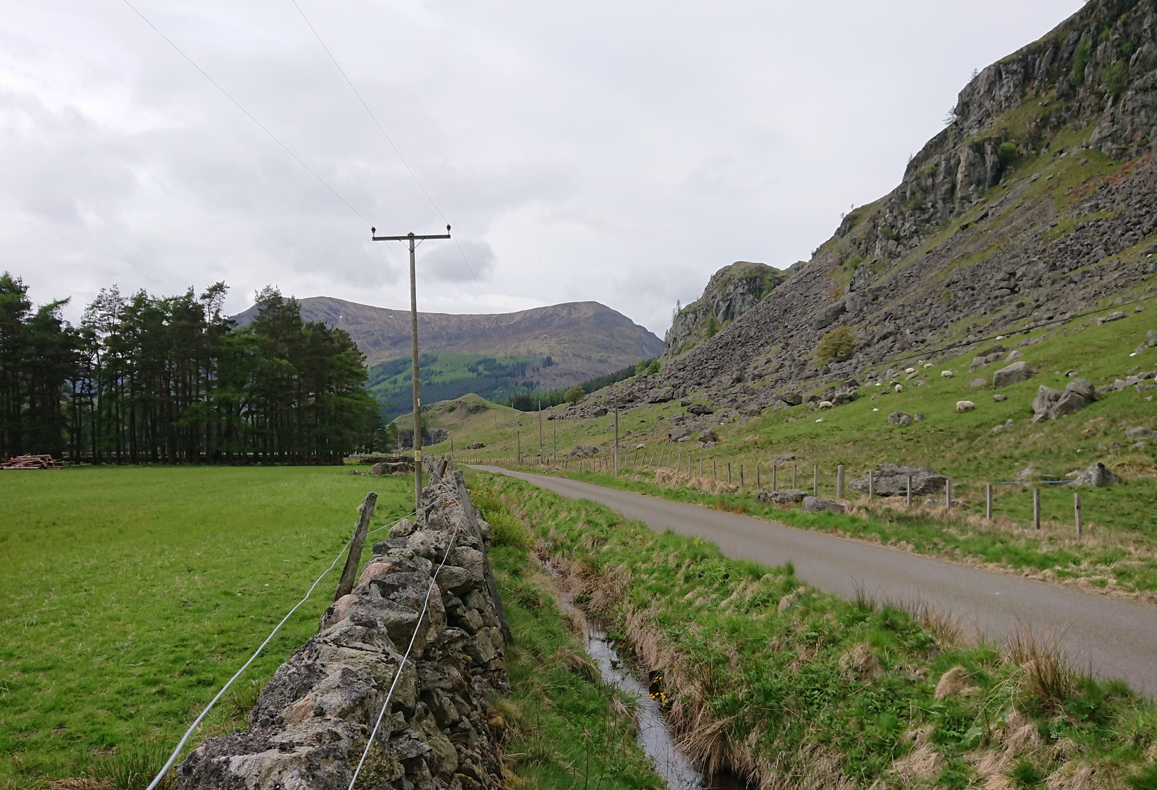
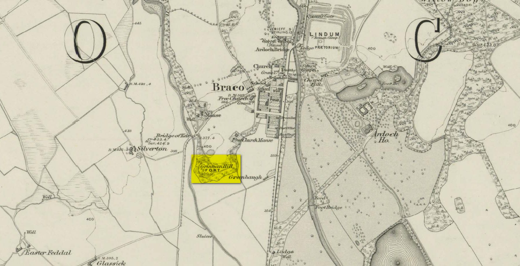
If you’re coming by car, Braco’s an easy place to park. Once here, walk up the main road, past the terrace houses until, on your left, you reach the B8033 Feddal Road. About 500 yards on, where the houses end and you reach the small river bridge, you’ll notice a footpath immediately on your left with a small table where you can have a cuppa. Walk past this, into the trees and along the riverside for barely 100 yards, and walk up the hillside on your left. On your way up are a couple of large humps, a bit like a small roller-coaster. You’re here!
Archaeology & History
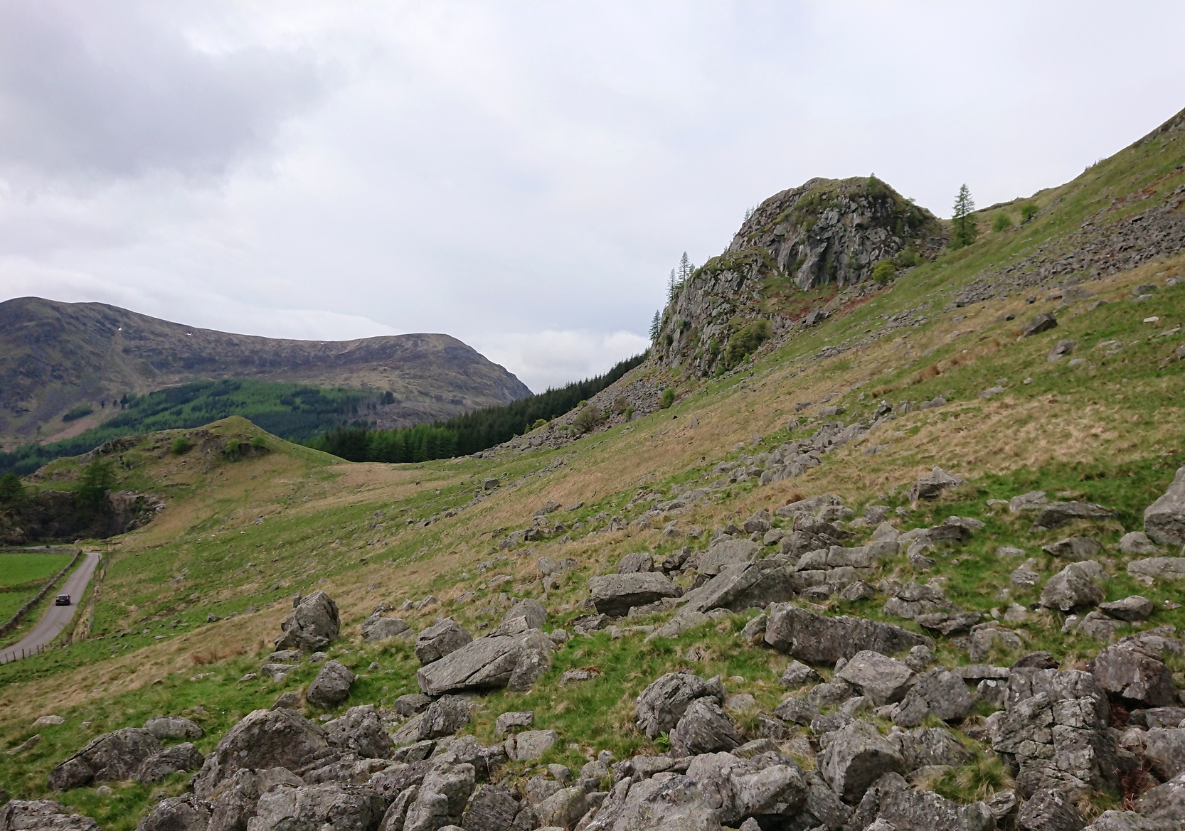
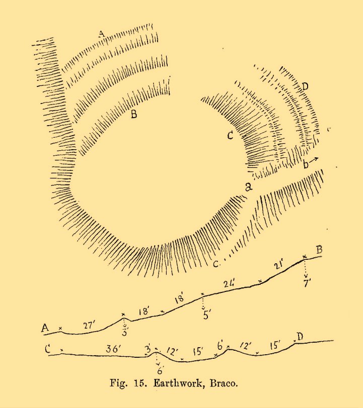
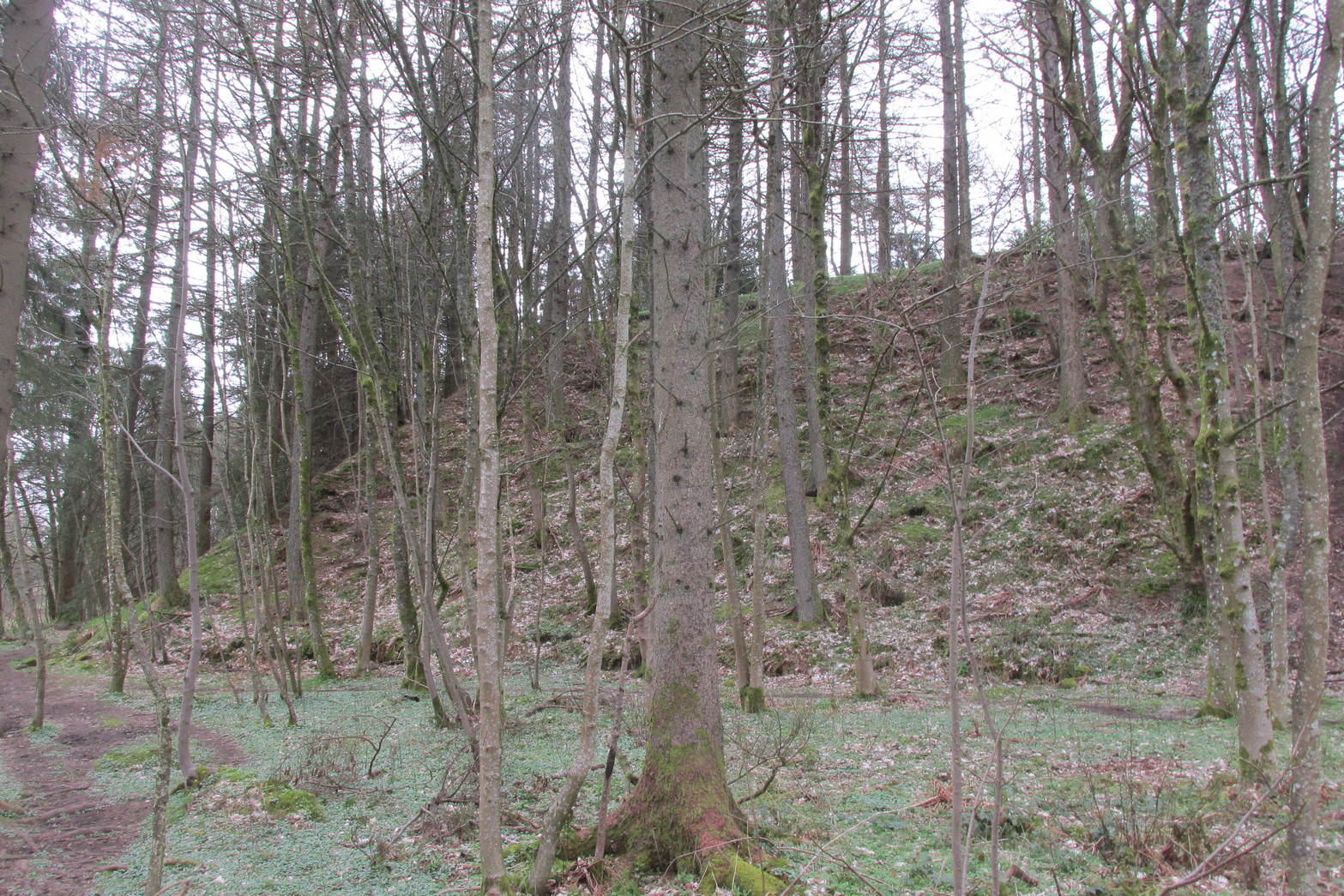
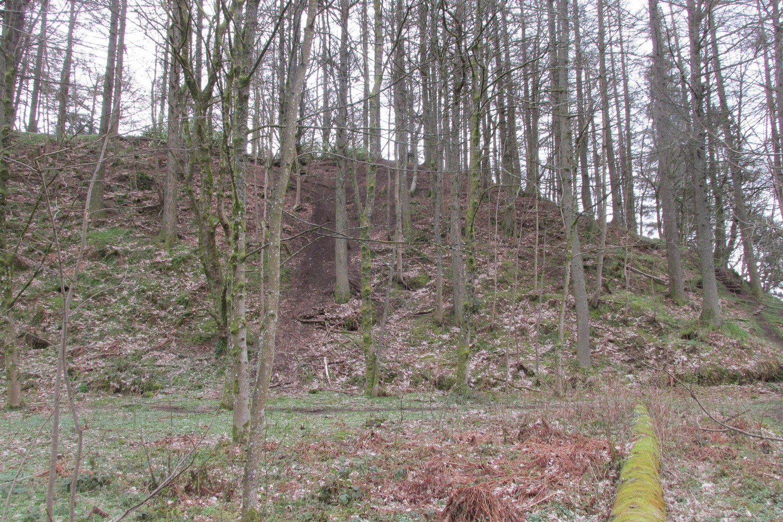
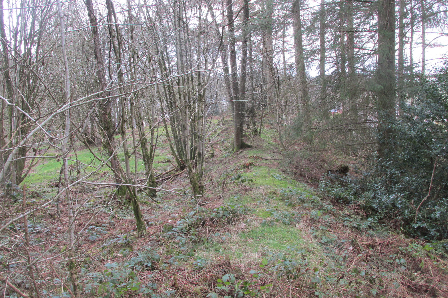
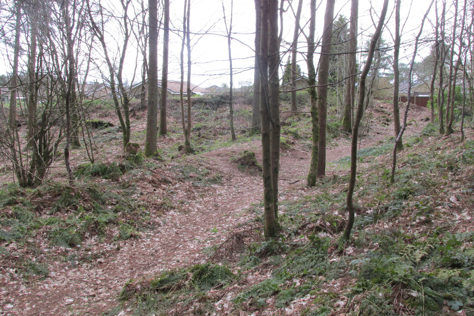
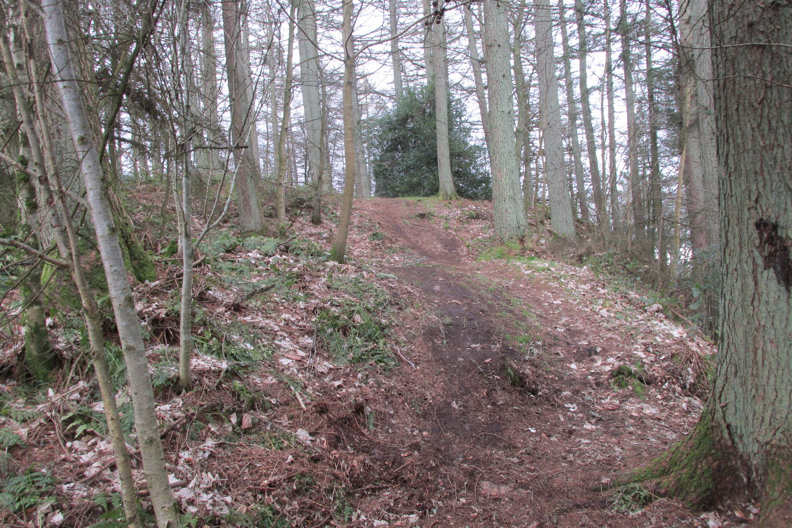
Antiquarians amongst you are gonna love this. It’s huge! Hiding away and all but forgotten in the little village of Braco, overgrown with trees and brambles, this steep wooded defensive structure has a series of large ramparts—three in all—that you’ll walk up and down before hitting a slightly undulating summit.
William Roy’s 1793 planChristison’s 1900 plan
The site was shown as an unnamed triple-ringed hill on William Roy’s 1747-52 survey of Scotland, with the lines representing the ramparts of this ‘fortress’. Some years later, Roy (1793) briefly mentioned the site when he was comparing indigenous fortifications with those of the Roman invaders, saying that “the small camp at Ardoch” probably “contained more than a Roman legion, with their auxiliaries.” His sketch and layout of the hillfort (right) is interesting in that it shows the more compete fortified ramparts on the north-eastern sides, which have today been covered by the modern houses. The ramparts in this part of the hillfort were still visible when the brilliant Miss Christian MacLagan (1875) came here; and in a subsequent visit by Mr Christison (1900) they could still be seen, as we can see in in his sketch (left). When we visited recently, it looked as if the lads who’d landscaped the large gardens most probably, unknowingly, used the soil of the ramparts to create them!
Apart from the missing northeastern ramparts, the site today is little different from when our antiquarians wrote of it more than a hundred years back. Read Miss MacLagan for example, who said:
“Near the parish church is an eminence called Grianan Hill, on which are still to be traced the remains of a British fort. The hill is a beautifully wooded knoll to the west of the village of Braco. It appears to be about 100 feet in height above the level of the surrounding land; on three of its sides the ground is perfectly flat, and we could suppose that in the amply days of the fort above, it had been environed on three sides by a lake, which would of course contribute to its strength. The fourth side of the hill, having but little natural strength, has been strongly fortified by three great walls. This is the side which connects the knoll with the neighbouring rising ground which is nearly as high as itself.
“The area enclosed by the innermost circular wall has a diameter of 130 feet. The space between this wall and the second is 37 feet, and the space between the second and third walls 47 feet. Almost every stone of this fort has been removed, but the lines and trenches which mark their former presence are still very distinct.”
Christison (1900) subsequently gave us much the same, with just some additional points here and there:
Looking up at SW sideLooking up at S side
“The site is less than ½-mile SW of Ardoch camp, 420 ft above the sea, on the edge of a steep descent, 40 to 50 ft high, to Keir Burn, but only slightly elevated above the field towards Braco village. It has apparently been an earthwork with a semi-oval triple line of defence…partly ramparted and trenched, partly terraced, the broad oval being rudely completed by the unfortified edge of the steep bank. The entrance, a, is along the narrow crest of a ridge, i, from the E, and it is likewise approached by a rude roadway, c, from the burnside below. Roy’s plan makes the work nearly complete, but the middle half of the lines no longer exists. He says that it may have been a work of the natives before the arrival of the Romans, but calls it a (Roman?) ‘post.’ There can be no doubt that it belongs to a common type of native fortresses. Its extreme length is about 320 ft, and the interior may have been about 200 by 170.”
Southern line of wallingFootpath along rampart
What he failed to point out—and contrary to Canmore’s comment that “the interior is featureless”—is the length of internal walling running nearly halfway through the top of the hillfort, cutting it in half so to speak, roughly southeast to northwest: the eastern area slightly larger than the west, which is a little higher. A ‘gate’ or passage between these two sides seems apparent halfway along this line of walling. This wall, like the long one running along its southern edge, is a couple of feet high and more than a yard across. In the western section a small pit has been dug, about eight feet across and a yard or so deep. Local lore tells that this was an old Roman fire-pit!
Around the very bottom mainly on the west-side of the hill, remains of old walling can be seen for a couple of hundred feet beneath the vegetation, but I’m unsure about the date of this structure. It may well be a 19th century construction, but without an excavation—and none has ever been done here—we will never know for sure.
Undulating ramparts
One final thought on this place is how is may have related with the large Roman forts that are just a few hundred yards away to the northeast. When the invaders came here, local tribal folk no doubt watched them with caution. One wonders whether or not some sort of ‘agreement’ was made between our local folk and the aggressive incomers, with them coming to some sort of nervous truce between them which allowed the Romans to build their camp to the east, as long as they kept their distance from the folk in this hillfort. Just a thought…..
References:
Christison, D., “The Forts, Camps and other Field-Works of Perth, Forfar and Kincardine,” in Proceedings Society Antiquaries, Scotland, volume 34, 1900.
Hogg, A.H.A., British Hill-Forts: An Index, BAR: Oxford 1979.
MacLagan, Christian, The Hill Forts, Stone Circles and other Structural Remains of Ancient Scotland, Edmonston & Douglas: Edinburgh 1875.
Roy, William, Military Antiquities of the Romans in North Britain, W. Bulmer: London 1793.
Acknowledgements: Huge thanks for use of the 1st edition OS-map in this site profile, Reproduced with the kind permission of the National Library of Scotland.