Holy Well (destroyed): OS Grid Reference – TL 997 254
Archaeology & History
Near the centre of the ancient city could once be found the flowing waters of St. Helen’s Well. It was described many times in various legal and land documents from as early as 1331 CE onwards, in Colchester’s Oath Book. However, descriptions of the site itself and its curative abilities were not noted. It was simply associated with St Helen’s Chapel, whose original foundations date from the 12th century.
Folklore
One tradition told that it was St Helen herself who founded the chapel here. St Helen’s feast day is Agust 18.
References:
Benham, W. Gurney (trans.), The Oath Book; or, Red Parchment Book of Colchester, Essex County Standard: Colchester 1907.
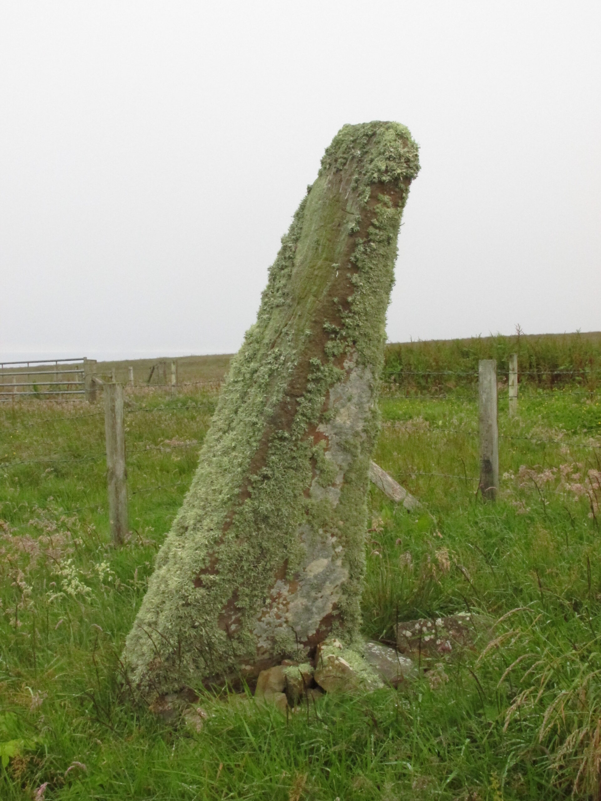
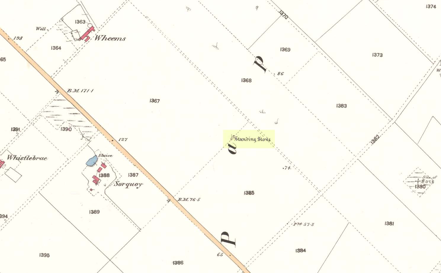
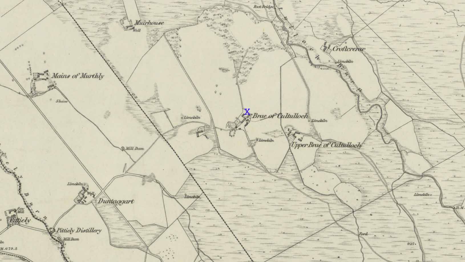
Take the third left road off the A961 past St Mary’s Hope, travelling south, taking the right fork at Lythes, and continue down to the end of the metalled road. From there, walk up the slope to your right (south) and follow the fence on your left into the next field and the stone will be seen in a fenced enclosure.
Archaeology & History
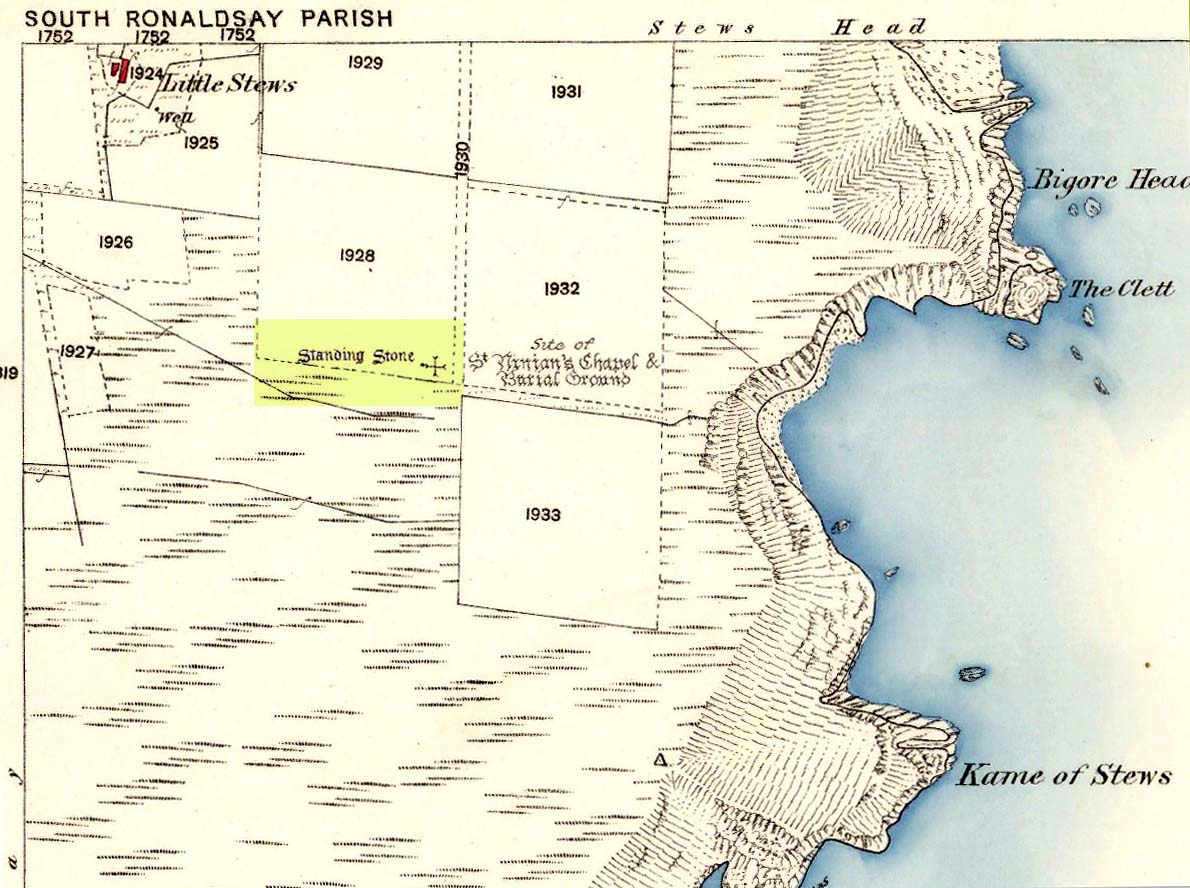
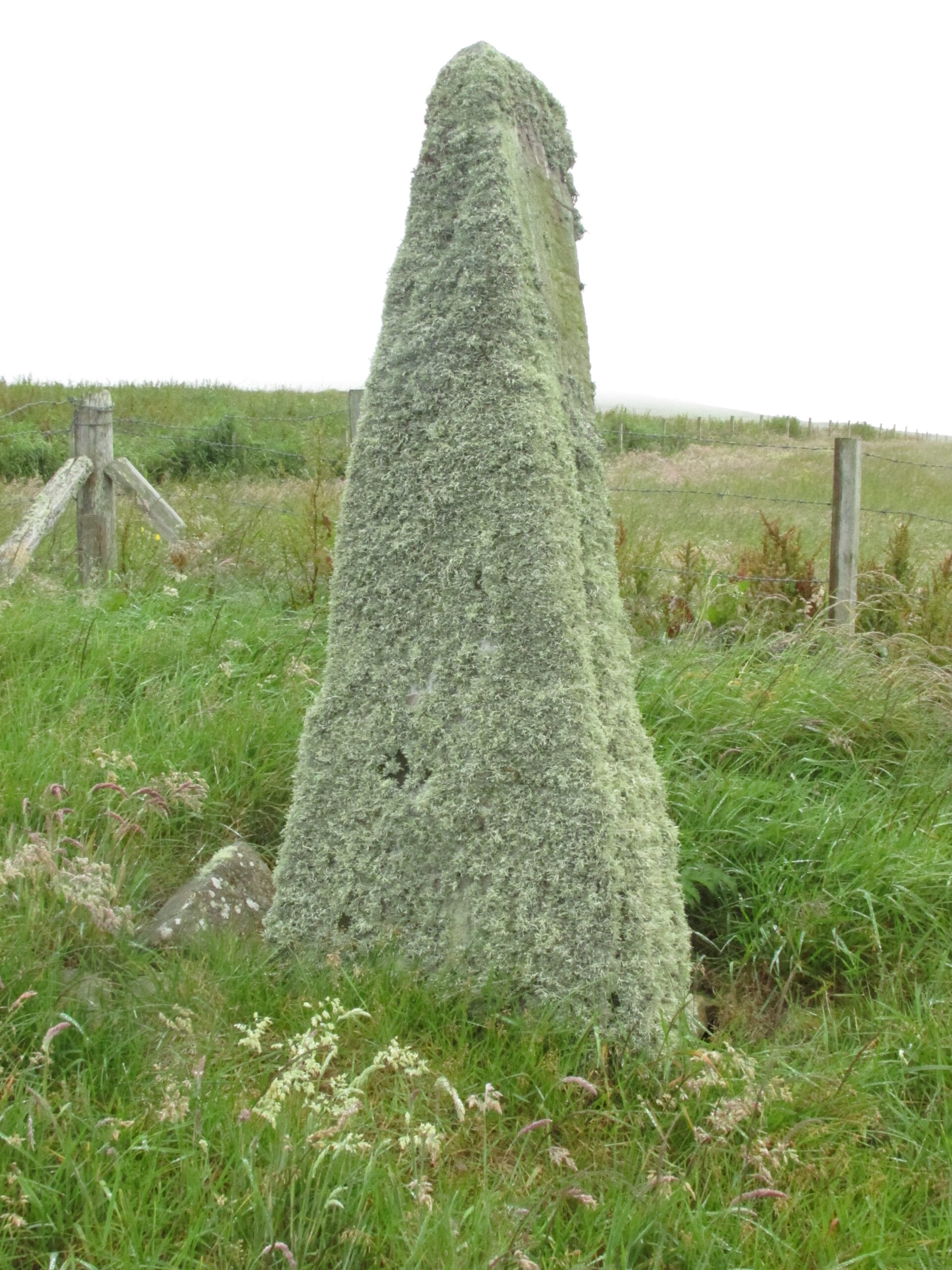
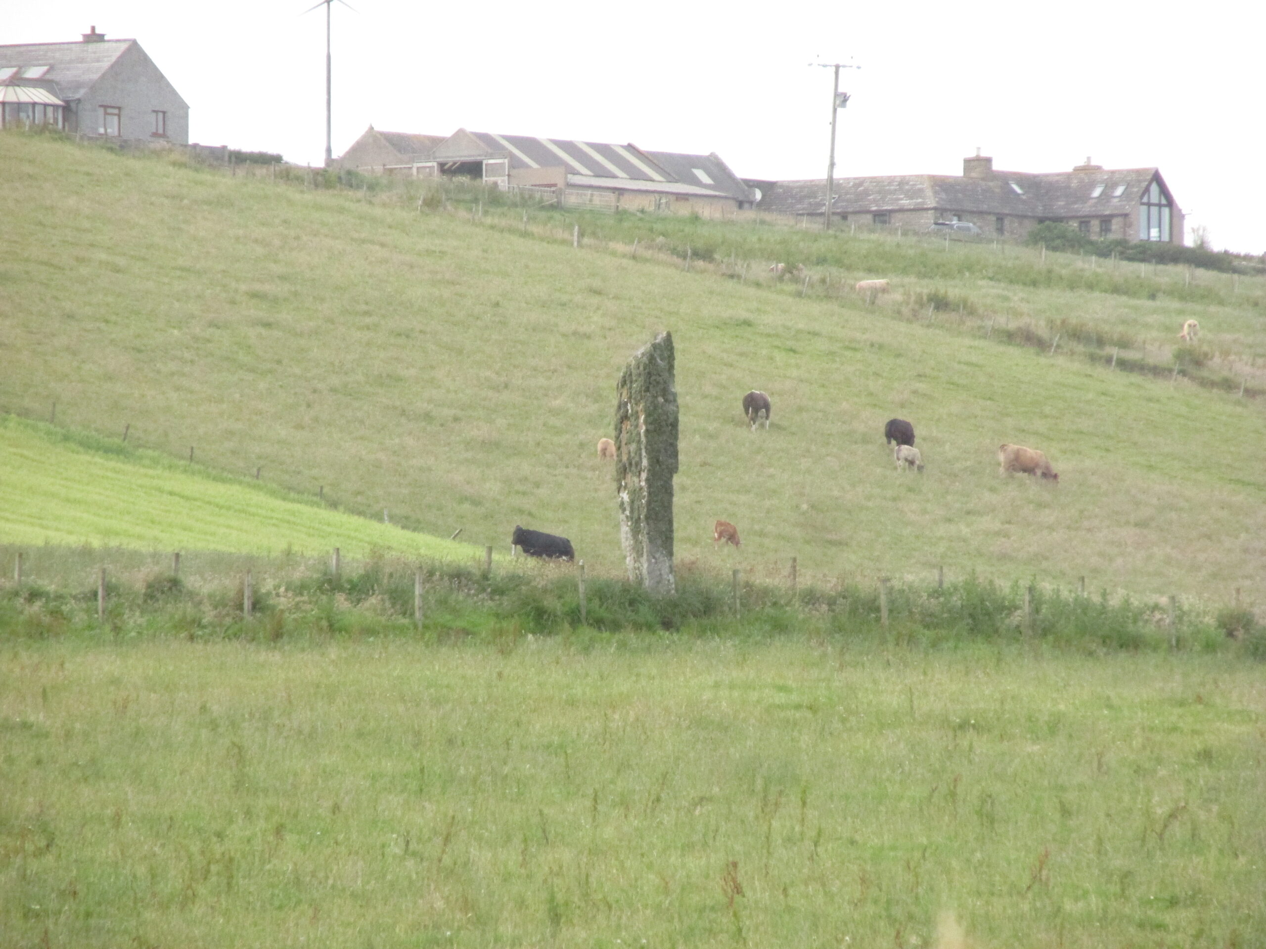
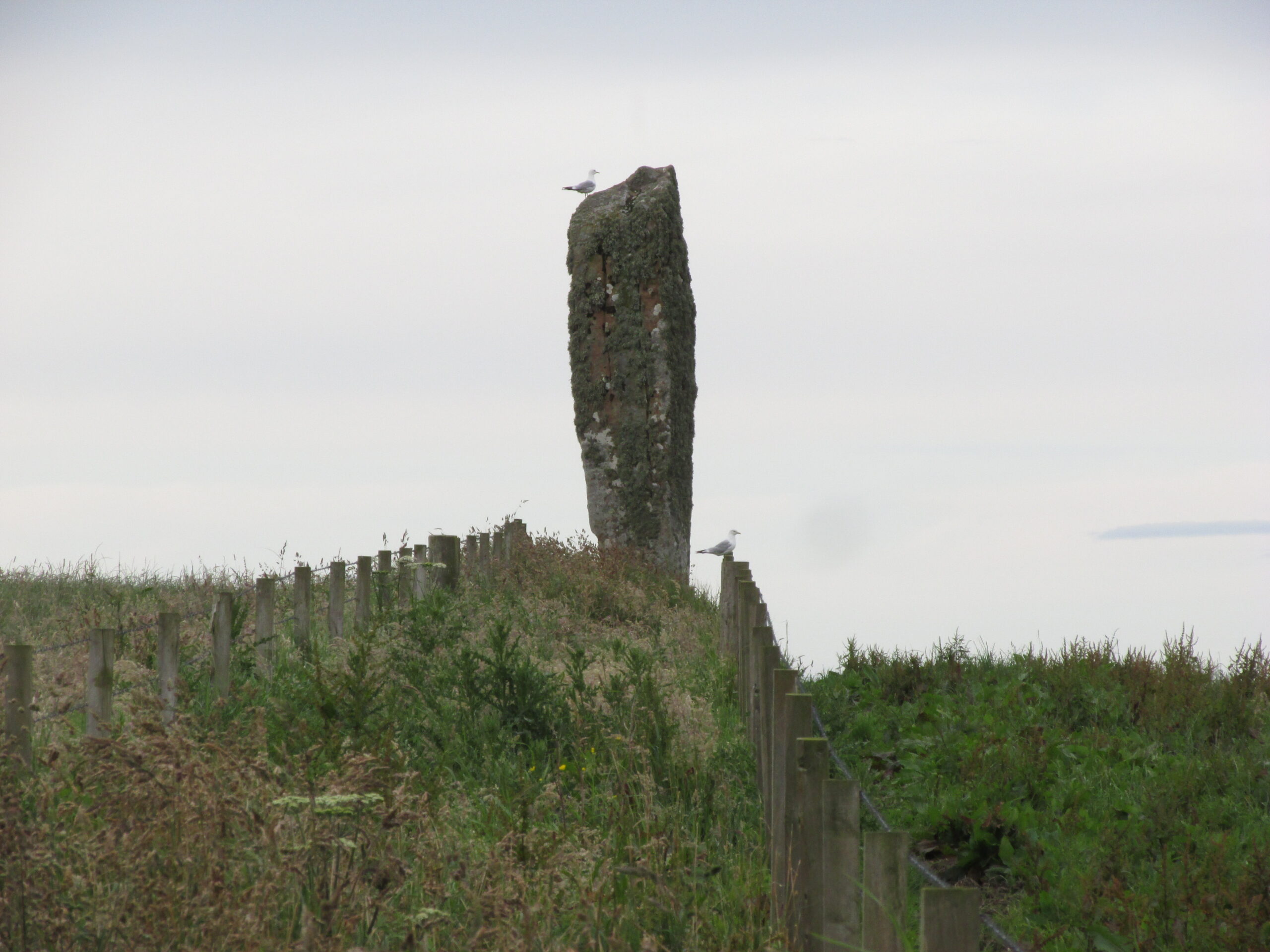
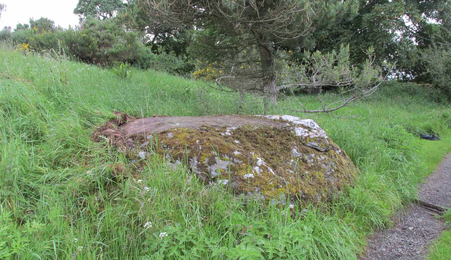
Two things strike you when you first see this stone, the triangular shape of the east facing side, and the lichen which covers this face and much of the rest of the stone giving it the distinct illusion of having a green velvet coat! From another angle it has a distinct lean and there are quite a few packing stones around its base. The Royal Commission inventory (1946) describes it thus:
Stone on 1881 map
“On a ridge barely a quarter of a mile S of the farmhouse of Stews is a triangular block of red sandstone nearly 6 ft high, set with a packing of small stones at the base and with its axis N-S. At the bottom where it is widest it measures 2 ft. 6 in. across and is from 12-13 in. thick. As it rises it tapers gradually to a pointed top, which is slightly inclined towards the W.”
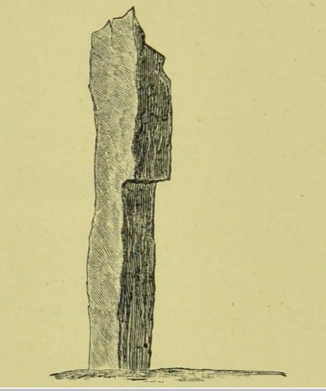
George Low on his 1774 tour wrote:
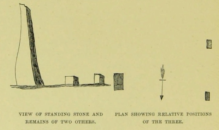
“Left this spot, and May 12th, proceeded southward by Stowse head; observed on the hill the remains of a tri-angular monument, but very much defaced, and two of the stones broke to the stumps. Tradition is there none as to the reason &c. of its erection. The figure with a plan follows…”
George Low’s 1774 sketchA coat of lichen
There is now no trace on the surface of the other two stones of this group so we are fortunate to have Mr Low on the spot sketch to record them. The stones would have been visible to the seafarers of times past who may have used them as navigation landmarks in pre-literate times, this being one of a number of surviving coastal stones on the Orkneys but whether they were erected for this purpose cannot be known. If you’ve been to see the Sorquoy stone up the coast, the surviving Stews stone is worth the journey if only for its ‘velvet’ coat.
References:
RCAHMS, Twelfth report with an inventory of the ancient monuments of Orkney and Shetland, 3v. Edinburgh. 1946
Low, George, A Tour Through the Islands of Orkney and Schetland…collected in 1774, William Peace & Son: Kirkwall 1879.
Acknowledgements: Big thanks for use of the 1st edition OS-map for this site profile, Reproduced with the kind permission of the National Library of Scotland.
Travelling south on the A961, take the first road left past St Margaret’s Hope, and follow it over the cross roads, and down the hill towards the sea, and it’s visible on the left hand side. You can’t miss it! It’s accessed by a narrow pathway which has been partly ditched – be careful!
Archaeology & History
View from the SEView from the track – SW
One of the less well known but most impressive of the Orkney standing stones, and seemingly one of the least visited. On my visit in July 2019, it was clear no one had walked the path for several months. The Royal Commission Inventory describes it as being, “14′ – 14′ 6″ high with some packing at the base. At 3′ above ground level, it is 2′ 6″ wide and 18″ thick, thickening to 21-22″ as it rises.”
It has a distinctly top-heavy look, and although invisible from the west above the brow of the hill, it can be clearly seen from the sea.
George Low visited the stone on May 11th 1774, saying:
‘In this beautiful hollow, in a cornfield, saw a large erected stone about 16 feet above ground, probably monumental, tho’ tradition is silent about it, and by digging nothing was found that could certainly prove this’.
Described by local historian George Barry (1748 – 1805):
George Low’s 1774 drawing
‘To the north (of South Ronaldsay), – at no great distance, is a most beautiful vale, with the ocean on one side, and gently declining hills on the other; which, for the production of every sort of beneficial crop, is far superior to any other part of the island. In the middle of this pleasant spot, on the brow of a hill, is a monumental stone, sixteen feet high, which, like many others through the country, bears no marks of human art, in carving, figures, or inscription. The whole delightful dale is known by the name of Paplay’ .
If you’re in the islands, this impressive stone is certainly worth a detour!
References:
Barry, Dr George, History of the Orkney Islands, Longman,Hurst,Bell & Orme: London 1808.
Low, George, A Tour Through the Islands of Orkney and Schetland…collected in 1774, William Peace & Son: Kirkwall 1874.
Royal Commission Ancient & Historical Monuments, Scotland, Inventory of the Ancient Monuments of Orkney and Shetland, HMSO 1946.
Acknowledgements: Big thanks for use of the 1st edition OS-map for this site profile, Reproduced with the kind permission of the National Library of Scotland.
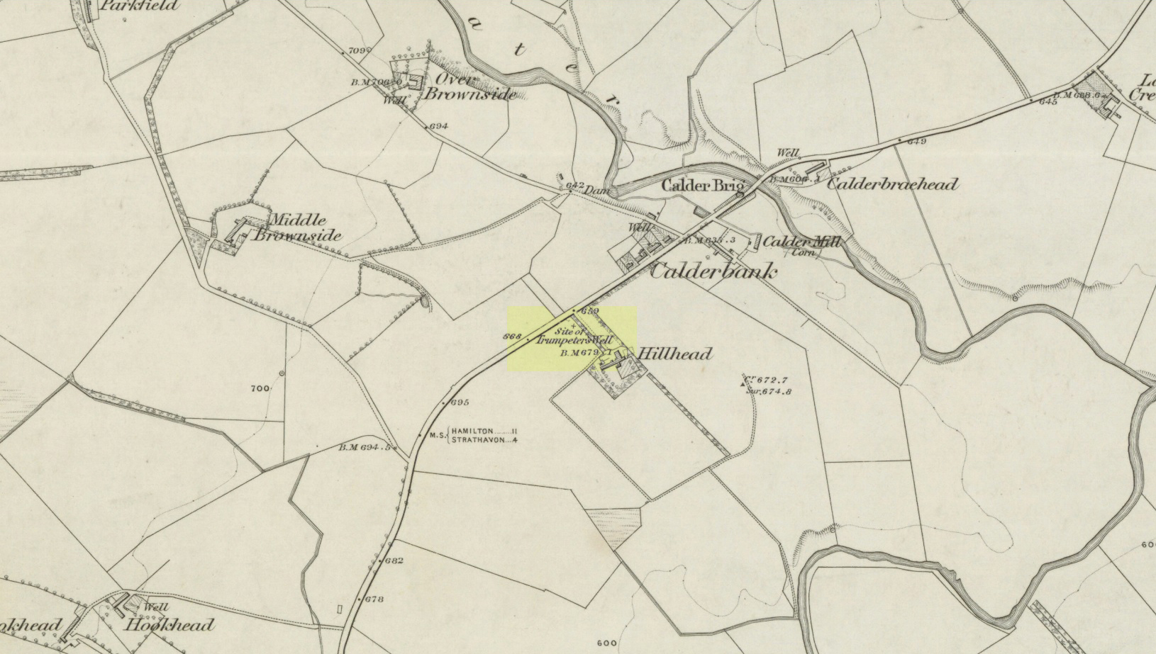
Take the A71 road southwest out of Strathaven as if you’re heading to Kilmarnock. After 2½ miles (4.1km) you reach the tiny hamlet of Caldermill (be careful or you’ll truly miss it!). As you go out of the hamlet, on your left there’s a track up to Hillhead Farm with the small but tell-tale signpost saying ‘Trumpeter’s Well’ and the small dome-shaped stone monument in the field is what yer looking for. If you’re coming from the Kilmarnock side, when you reach the Caldermill sign, it’s in the field immediately to your right. Y’ can’t really miss it.
Archaeology & History
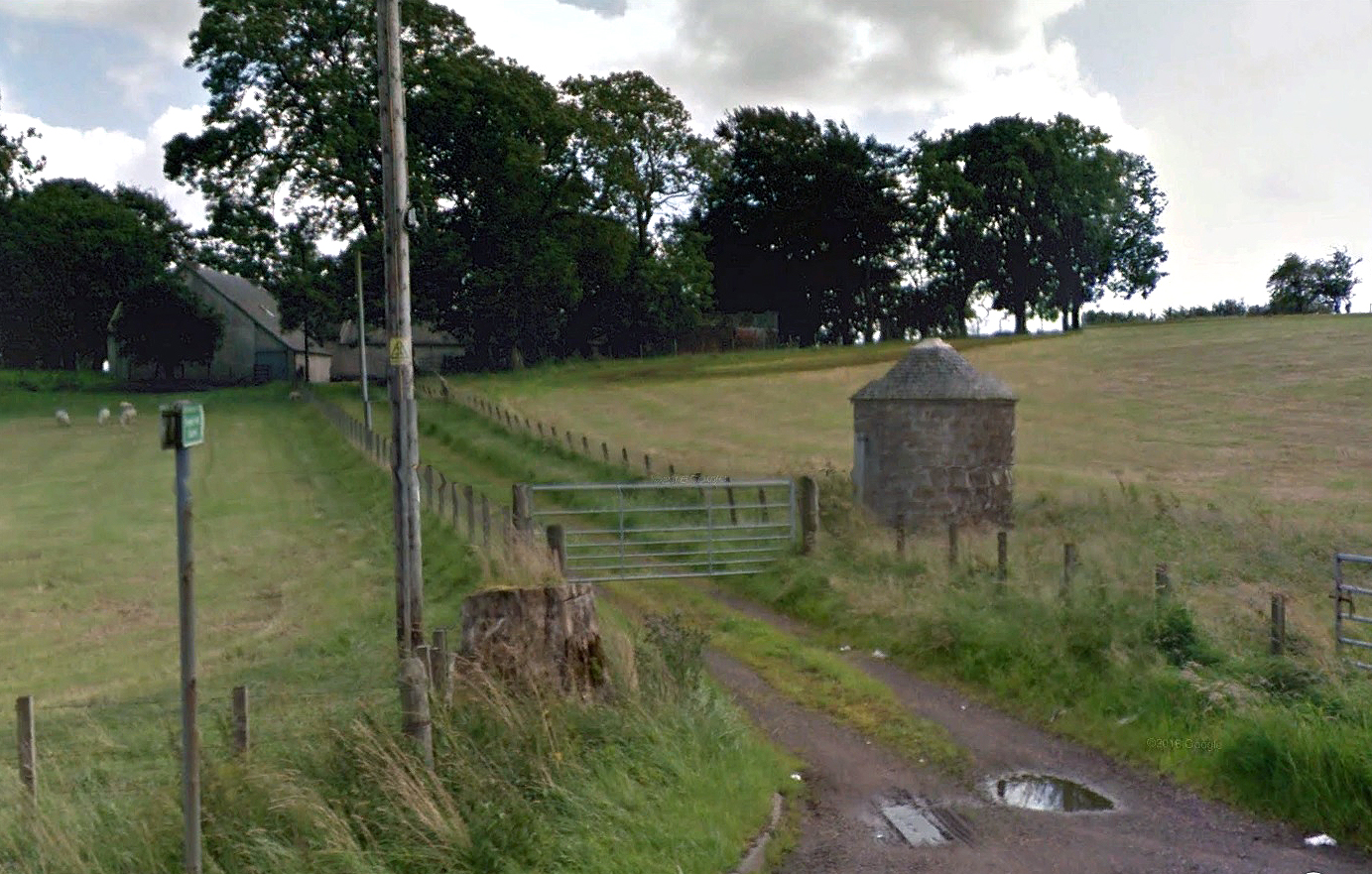
When the site was surveyed by the Ordnance Survey lads in the 1850s, the water supply had completely run dry. It was later revived and the nine-foot tall circular stone building built to commemorate its history. The water apparently now runs within the building, being supplied from Hillhead Farm.
Trumpeters Well, Caldermill
Folklore
The well is said to have gained its name after the local Battle of Drumclog (1679), when one rich Tory known as John Graham of Claverhouse was retreating for fear of his life; and because his own horse had been killed, the coward stole the horse of his young fourteen-year-old trumpeter. In doing so, the young lad was subsequently killed and his body was thrown down the well. Tradition also tells that other soldiers were buried in the same field.
References:
Campbell, J. Ramsey, My Ain, My Native Tour – Stra’ven, J.M. Bryson: Strathaven 1943.
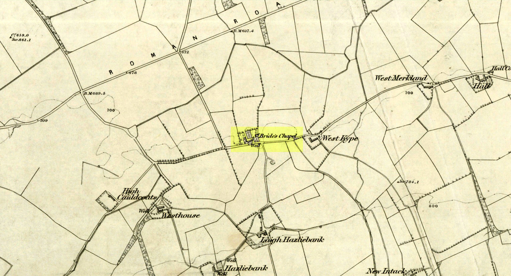
Holy Well (destroyed): OS Grid Reference – NS 6983 4138
Archaeology & History
St Brides Chapel & Well on the 1864 OS-map
Shown on the 1864 OS map of the area as a ‘Well’ just at the front of St Bride’s Chapel—now a very pleasant old cottage—peasants and pilgrims would stop for both refreshment and ritual here as they walked down High Kype Road. Although the chapel was described in church records of January 1542 as being on the lands of Little Kype, close to the settlement of St Bride, there seems to be very little known about the history or traditions of the well. If anyone has further information on this site, please let us know.
Folklore
Bride or Brigit has her origins in early British myth and legend, primarily from Scotland and Ireland. Her saint’s day is February 1, or the heathen Imbolc (also known as Candlemas). Although in christian lore St. Bride was born around 450 AD in Ireland and her father a Prince of Ulster, legend tells that her step-father (more probably a teacher) was a druid and her ‘saintly’ abilities as they were later described are simply attributes from this shamanic pantheon. Legends—christian and otherwise—describe Her as the friend of animals; possessor of a magickal cloak; a magickian and a healer; and whose ‘spirit’ or genius loci became attached to ‘sacred sites’ in the natural world, not the christian renunciation of it. St Bride was one of the primal faces of the great prima Mater known as the Cailleach: the greater Gaelic deity of Earth’s natural cycles, whose changing seasons would also alter Her names, faces and clothes, as Her body moved annually through the rhythms of the year. Bride was (and is) ostensibly an ecological deity, with humans intrinsically a part of such a model, not a part from it, in contrast to the flawed judaeo-christian theology.
References:
Paul, J.B. & Thomson, J.M., Registrum Magni Sigilli Regum Scotorum: The Register of the Great Seal of Scotland AD 1513 – 1546, HMGRH: Edinburgh 1883.
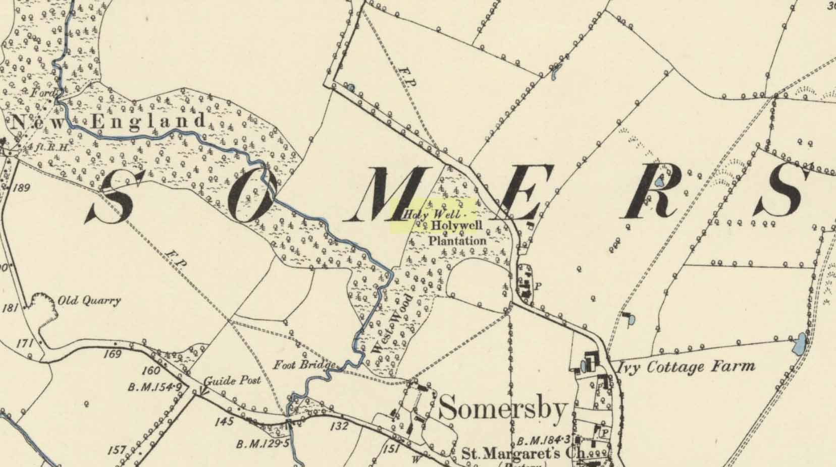
Curiously missing from Thompson’s (1999) Lincolnshire survey, this old watering place can apparently still be found in the appropriately named Holywell Wood, just north of this lovely little hamlet. Shown on the 1887 OS-map of the area, it’s first literary reference seems to be in George Weir’s (1820) early survey of Horncastle district where he gives it a brief mention, saying:
“In a woody dell in this parish is a spring, gently bursting from the rock, called Holy-well, but the name of the saint to whom it was dedicated is not preserved.”
…Like oh so many others. But its ‘holiness’ may devive from other more archaic origins, in the spirit of the woods from whence the waters emerge. Certainly that’s what the poet laureate Alfred Lord Tennyson would have had us believe. He grew up in Somersby village and this old well was one of his places of inspiration. When the local writer H.D. Rawnsley (1900) described Tennyson’s affection for this site, he told us that,
“Alfred peopled that Holywell Wood with forms of fairies, and made the whole surrounding circle of the hills, a theatre for enchantment and chivalry.”
J.C. Walters 1890 sketch
Nature can certainly do that to anyone who wanders Her body with open reverence.
Although the place is now quite overgrown, it wasn’t always this way. There used to be a well-trodden path with a gateway at the entrance that took you into the woods and up to the well. Above the gateway there used to be a Latin inscription that read, Intus aquae dulces, vivoque sedilia saxo, Et paulum silvae superest. His utere mecum. (meaning something akin to, “At these sweet waters, by this living seat of stone and small forest remains, Make use of me.”)
When J.C. Walters wrote about it, he told that a “local student” gave him the following particulars:
“A series of steps led down into the well, a post was fixed in front of it, and a cross-bar extended thence to the rock. On the cross-bar was a ring with a rope attached, so that the bather might safely descend into the well and enjoy the healing virtues of the stream which rushed from the rock. Geologists say that the wold villages are so closely placed on account of the superior quality of the water which springs up wherever the Spilsby sandstone meets the Kimmeridge clay. Susan Epton (Mrs. Thompson), Miss Emily Tennyson’s maid, tells me that she can remember the time when visitors came in scores to “take the waters.””
Some of this was later echoed in Rawnsley’s (1900) biographical account of Tennyson. He talked with a local sexton about the folklore of the area who told him of his memories:
“Halliwell wasn’t growed up then; there was a bath-house with steps down to the watter, and fwoaks in carriages came from far and near to drink it. Wonderful watter! it was nobbut a bit sen, that our owd nebbur was liggin’ adying and he axed for a cup o’ watter from the Holy Well, and they sent and fetched it, and he took it and went off upon his feet. Why, i’ my time theer was a school-house down in Halliwell Wood, and a skittle halley close by the well, but all them things is changed now, excep the snowdrops, and they coomes oop reg’lar, a sight on ’em i’ Halliwell.”
Out of Aberfeldy, take the A826 road as if you’re going up Glen Cochill. Not far up, just where the housing of Aberfeldy itself ends and the green fields open up either side of you, keep on the road for a half-mile where you meet a small copse of trees on your left, with a dirt-track that runs down the slope. Go along the track for 0.8 miles (1.3km), past the Ursa Major Stone and where the track splits, go left past the Quartz Stone and follow the track through the farmyard. It’s somewhere there – or is supposed to be!
Archaeology & History
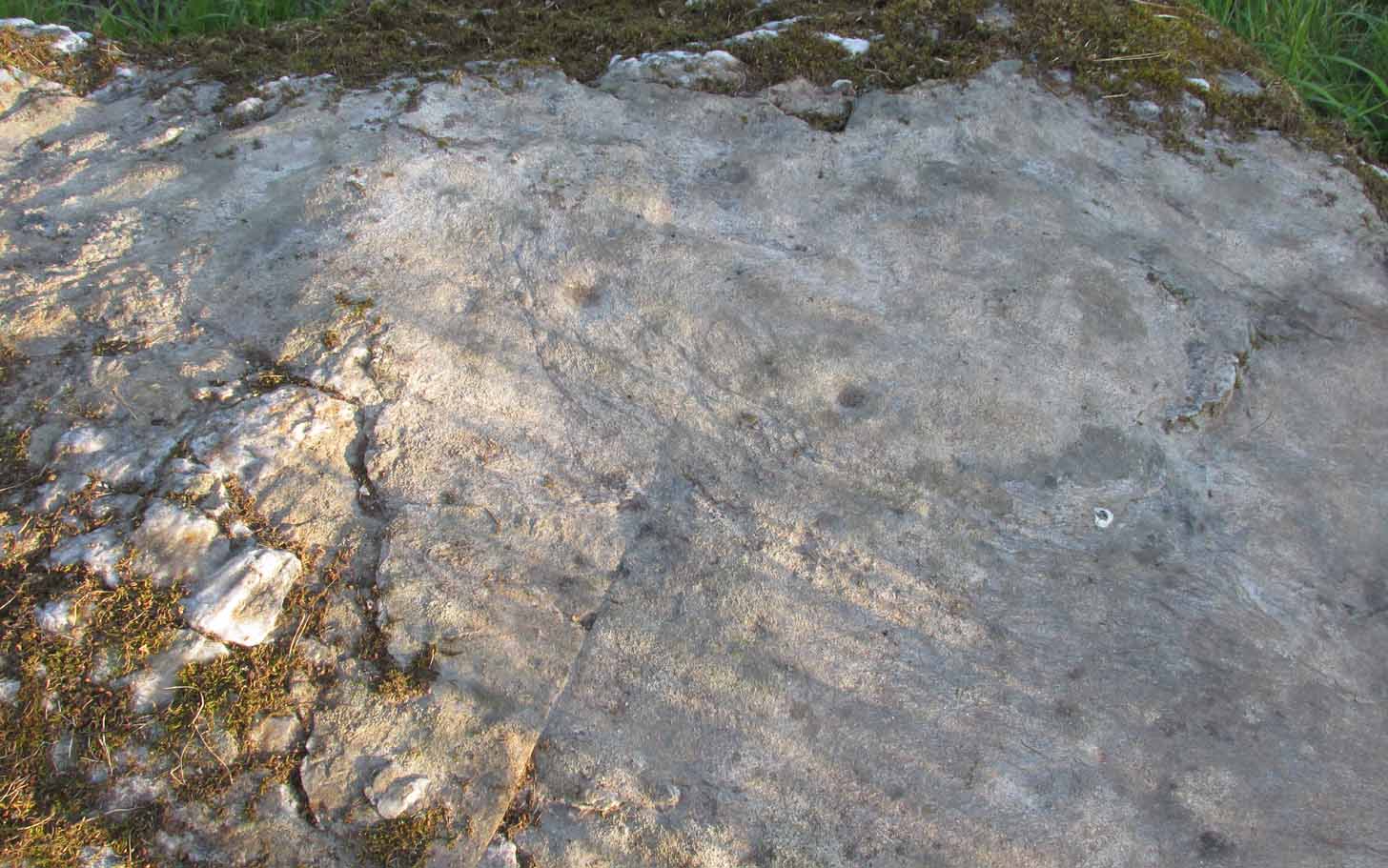
On our visit here, we couldn’t locate the cup-and-ring stone that’s described in Sonia Yellowlee’s (2004) regional rock art survey. She described it, as archaeologists always do, in the briefest manner, telling us simply:
“Leaning against a pile of rubble in the farmyard there is a split boulder bearing eighteen cupmarks, one of which is ringed.”
It may have been destroyed, as we were told by a couple of locals that there used to be “a real miserable sod” living there. When we visited the place and tried to ask the present farm owner, sadly he wasn’t to be found. If any rock art explorer manages to locate this seemingly lost cup-and-ring, please let us know – and mebbe send us some photos so that we can add them to this site profile. 😉
References:
Yellowlees, Sonia, Cupmarked Stones in Strathtay, RCHAMS 2004.
Acknowledgements: Big thanks to the crew – this time being Neens Harris, Paul Hornby & Frank Mercer. And the stunning resource of Scotland’s 1st edition OS-maps is Reproduced with the kind permission of the National Library of Scotland.
Out of Aberfeldy, take the A826 road as if you’re going up Glen Cochill. Not far up, just where the housing of Aberfeldy itself ends and the green fields open up either side of you, keep on the road for a half-mile where you meet a small copse of trees on your left, with a dirt-track that runs down the slope. Go down here and follow the slightly meandering track for 0.8 miles (1.3km), a short distance past the Ursa Major Stone where the track splits. Take the track to the left and there, less than 100 yards on you’ll hit a large boulder on your left. That’s it!
Archaeology & History
Not previously recorded, this simple cup-marked stone will probably only be of interest to petroglyph aficionados, or those folk who are into ‘energies’ at sites. This latter aspect is due entirely to the carving being etched onto a huge rock, much of which is composed of quartz—which isn’t too unusual in this part of the world. But that aside…
Looking down at the cupsThe cupmarks highlighted
It is one in a group of carvings within a few hundred yards of each other, with its nearest neighbour 20 yards to the north. That one’s covered in cups—but on this large Quartz Stone, only two of them exist, on the top near the centre. Just a couple of inches across and half-an-inch deep, they’re pretty clear once you see them. The raised piece of ground behind the stone is artificial and has variously been described by antiquarians and archaeologist alike, as either a prehistoric dun, or a stone circle. Whatever it may be, some of it is certainly man-made. Check it out – and mebbe ask the friendly fat fella who lives nearby and what he thinks.
Out of Aberfeldy, take the A826 road as if you’re going up Glen Cochill. Not far up, just where the housing of Aberfeldy itself ends and the green fields open up either side of you, keep on the road for a half-mile where you meet a small copse of trees on your left, with a dirt-track that runs down the slope. Go down the track, bending to the right, then the left and then on for a quarter of a mile until the lines of trees appear either side of you. Barely 200 yards along, the track swerves slowly to your right, and the field above you slopes uphill. Keep your eyes peeled at the fencing on your right and you’ll see a stone sloping towards you right by the fence with faint cup-marks on it. You’ll find it!
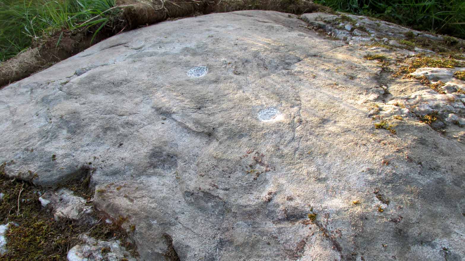
Archaeology & History
A truly fascinating cup-marked stone recently uncovered by Paul Hornby on another one of our TNA meanderings. Fascinating because of the curious arrangement of the cups on the stone. Often, cup-marked stones have little to interest the causal visitor – but this one’s different. As can be seen quite clearly, the cups are arranged in the shape of the constellation of the Great Bear, or Ursa Major – albeit with an extra ‘star’ in this design. But it’s damn close! In all likelihood (he says with his sceptical head on 😉 ), the design is fortuitous when it comes to the Ursa Major. I know from many years experience how easy it is to see meaningful shapes and designs in the almost entirely abstract British petroglyphs, but the design is very close to the constellation we all got to know when we were kids.
Looking along the stoneGazing down at Ursa Major
The stone itself slopes upwards at an angle of about 60º, before starting to level out as it rises. All of the cup-marks have been pecked onto this sloping surface (the vast majority of carvings are found on top of stones). Altogether, at least twelve faint and shallow cups were exposed when we looked at it—measuring the usual inch to inch-and-half across—but it is likely that more of them are hidden beneath the turf at the top of the stone. We could discern no rings or other features in the design.
This is just one carving amidst a good cluster of petroglyphs within a few hundred yards of each other (the Quartz Stone being one of the nearest) that are well worth checking out if you like your rock art. It may also be of interest to astronomy students, or those exploring archaeo-astronomy.
References:
Yellowlees, Sonia, Cupmarked Stones in Strathtay, RCHAMS 2004.
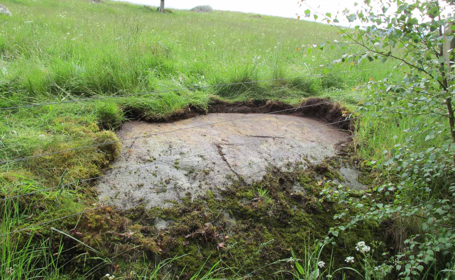
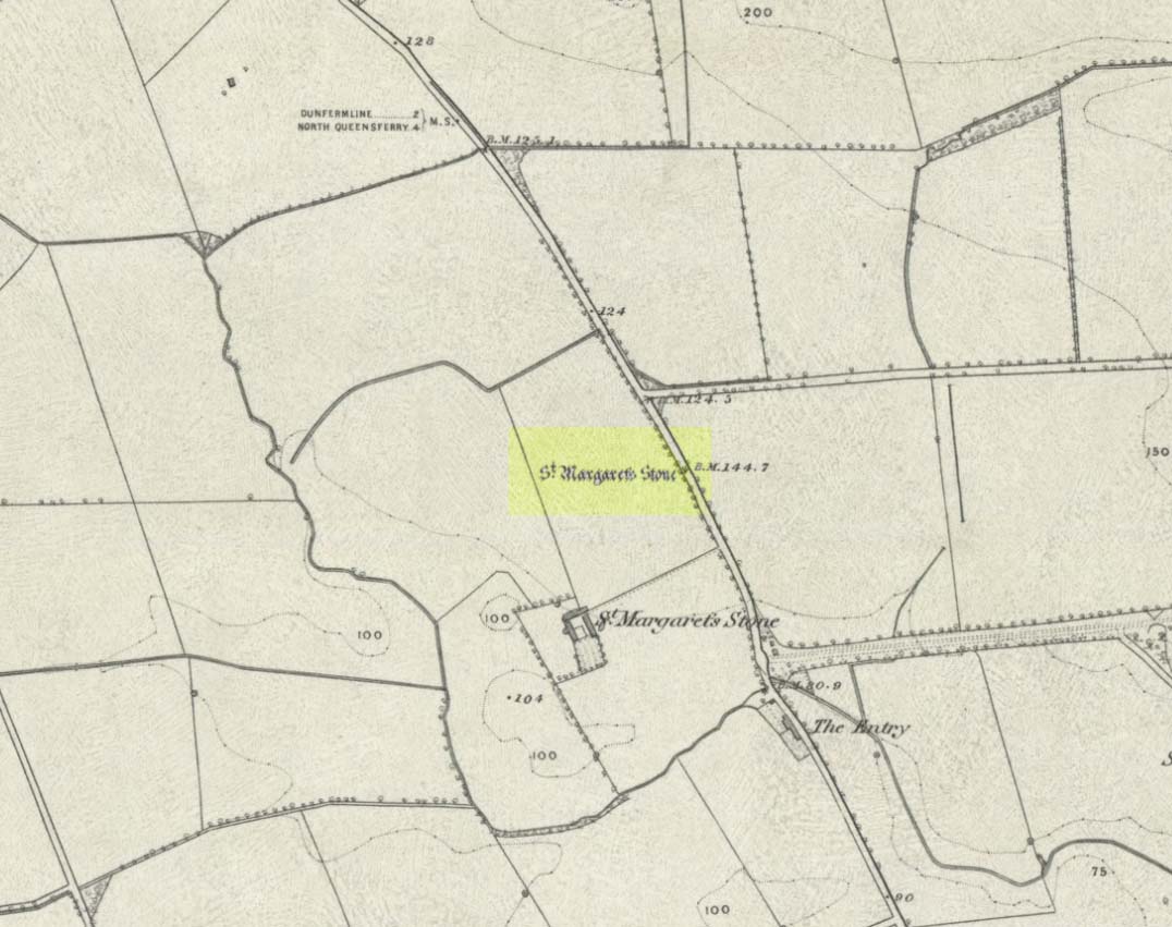
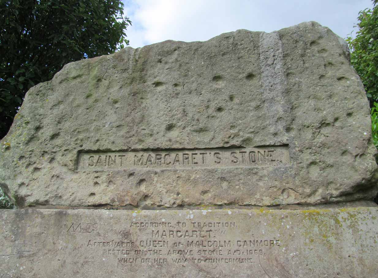
Take the A823 road out of Dunfermline south towards Rosyth. A half-mile before you hit the motorway roundabout, at the roundabout where Carnegie Avenue takes you east, turn west and park up along the road where the modern business park lives. 30-40 yards from the roundabout, set back on the pavement, you can’t really miss the huge flat slab of stone, covered in cup-markings, resting on a stone plinth with ‘St Margaret’s Stone’ stamped on it!
Archaeology & History
On the 1856 OS-map of this area, St Margaret’s Stone is shown at the roadside just above a farm of the same name, a short distance away from its present location. In October 1879, Alexander Stewart (1889) told us that funds were raised and steps taken to properly fix and preserve this ancient ‘resting-place’ of Queen Margaret on the Queensferry Road. It was quite a few years later before it was moved the few hundred yards further to its present location.
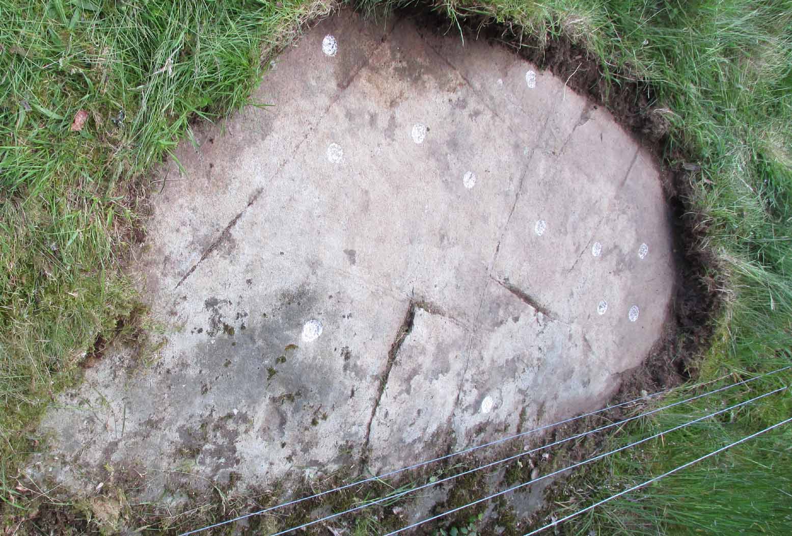
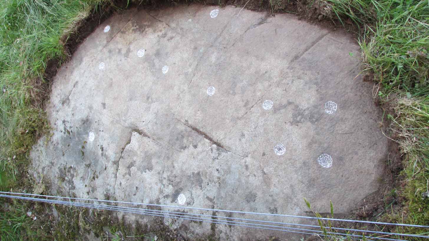
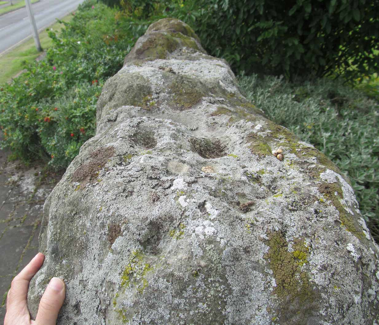
Cups on stone’s edge
Early writers tell us that originally its position in the landscape was on the crest of one of the rises in the land between Dunfermline and the sea, making it visible for some considerable distance. This would seem to have been a deliberate placement. In my mind, and in accordance with the placement of many a prehistoric tomb, St Margaret’s Stone may originally have been part of a neolithic or Bronze age cairn, long since gone. The size and shape of the rock implies it too, with similarities here of the impressive cist or gravestone found inside the Netherlargie North cairn at Kilmartin. However, this wasn’t the thought of the prodigious Scottish historian, William Skene. He thought that St Margaret’s Stone originally stood upright, being a Pictish-style standing stone that was mentioned in the first Statistical Account of the area. The brilliant Scottish antiquarian, John Stuart (1856)—who gave us an illustration of the ‘standing stone’ in question—told us:
“It has been supposed by some that “St. Margaret’s Stone,” a block now lying on the side of the highway leading from Inverkeithing to Dunfermline, and about midway between these places, can be identified with the standing stone referred to in the Statistical Account. Mr Skene has noted below a sketch of St. Margaret’s Stone:- “The sculpture upon this stone has been lately chipped off in mere wantonness, so as to leave few traces of the subject recorded upon it.” He farther states that it formerly stood erect, and was called “The Standing Stone.” According to Mr. Skene’s measurement, St. Margaret’s stone is about nine feet and a half in length, one foot in thickness, and four feet broad at the widest end, and broken off to a narrow point at the other.”
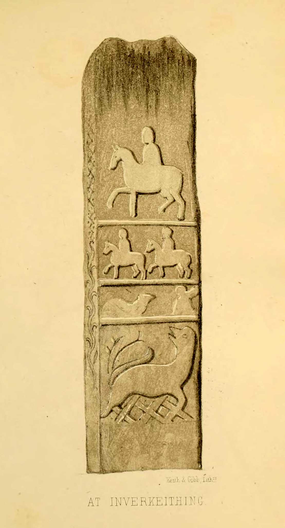
The missing ‘standing stone’
In this instance, Skene was confusing St Margaret’s Stone with the lost Pictish monolith (left) that used to exist nearby, which had carved horse figures and other memorial designs upon it and which he thought had faded away. Whereas the large slab we are looking at here, and which Skene visited and measured, is covered on one side by a gathering of prehistoric cup-markings—much earlier than any Pictish or early christian carvings. At first glance, it seems that some of these cups may well be natural, but it has to be said that some of them are distinctly man-made. And if we were to believe the archaeo-accounts of the stone, the cupmarks are only to found on one side of the stone. This is incorrect. As we can see here, a number of cupmarks run along the edge of the stone. We cannot say for sure whether all of them are artificial, but they certainly look like it! Also, on the other side of the flat surface, one or two single cups are visible. It would be good if we could get an artist to give us a detailed impression of the prehistoric carvings without the modern engraving of St Margaret’s Stone etching on the main face. (is there anybody out there!?)
The Royal Commission (1933) lads visited the stone in 1925 and, several years later in their write-up, told us simply:
“This stone…stands with its main axis due north and south and measures 8 feet 6 inches, by 4 feet 7 inches, by 1 foot 6 inches. On one side the entire surface is cup-marked, the markings varying in size from 1¼ inches to 3¼ inches and having an average depth of from ½ to ¾ inch.”
When the Scottish petroglyph writer and explorer, Ron Morris (1968) came to the site, he gave it an equally brief description, merely telling us:
“On standing stone (8 1/2 feet high, 4 1/2 feet wide), built in to roadside fence, over 80 cups, up to 4in in diam, 3/4in deep, some run together as rough dumbells.”
It’s well worth checking out!
Folklore
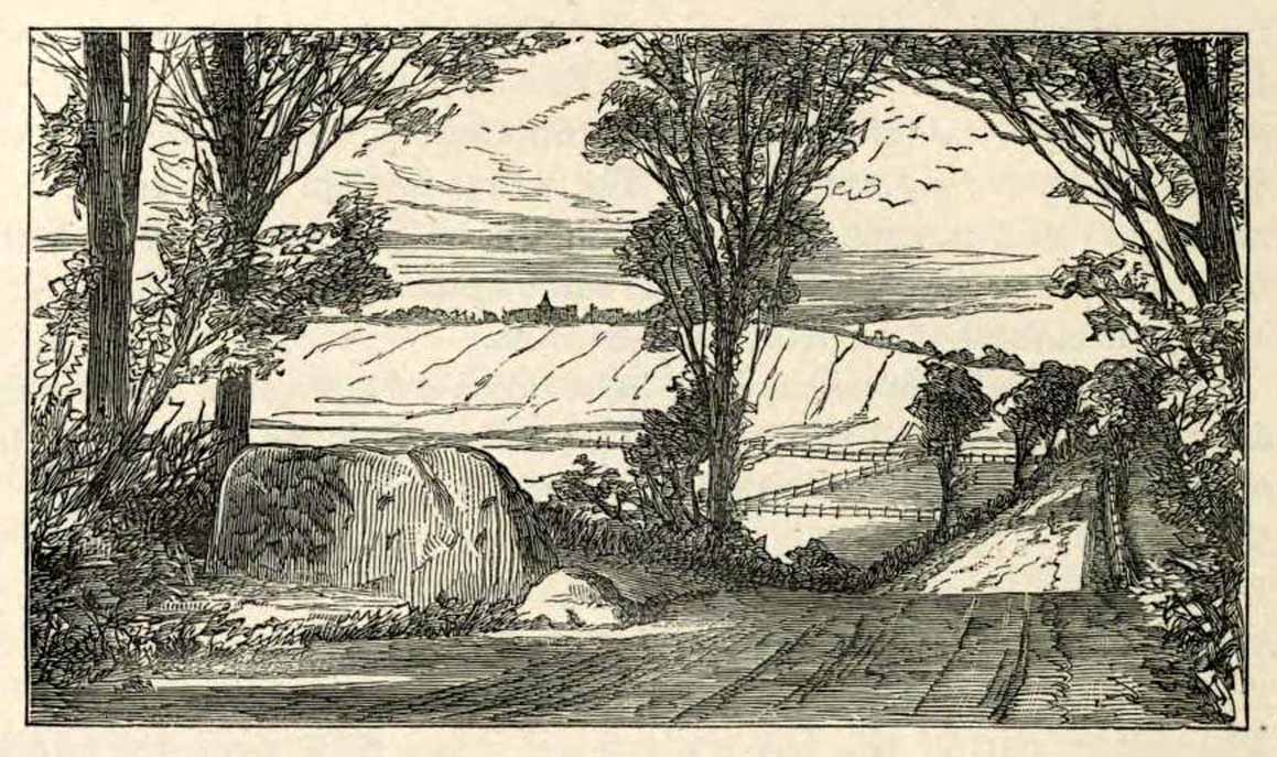
St Margarets Stone in 1825
When the Saxon Queen Margaret landed on the shores just west of Queensferry at Rosyth Castle (NT 1087 8200), legend reputes that she and her entourage made Her way north towards Dunfermline. Halfway along the ancient track She rested at this large stone which, thereafter, gained the name by which we know it today. It was said that Queen Margaret subsequently visited the stone on a regular basis for periods of solitude. The tale probably has some germ of true in it. Additional ingredients also told that,
“The large stone here is associated with St Margaret and was visited by women who hoped to conceive or sought a successful birth. The eight-foot high stone is said to mark the resting place of St Margaret when she journeyed between Queensferry and Dunfermline. Margaret had eight successful pregnancies and probably needed to rest quite a few times on her travels!”
The fertility aspects of the rock were not the only pre-christian virtues attached to it. We also find that oft-cited motif of rocks moving of their own accord: in this case, as J.B. MacKie (1905) told us, local people had always
“been told that the stone rose from its bed and whirled thrice round in the air every time it heard the cock at the adjoining farm crow.”
Cocks crowing are symbolic of sunrise, obviously, and this lore may simply represent a folk memory of the spirit in/of the stone being animated at that time of day. It’s a motif found at ancient sites all over the place!
Royal Commission Ancient & Historical Monuments of Scotland, Inventory of Monuments and Constructions in the Counties of Fife, Kinross, and Clackmannan. HMSO: Edinburgh 1933.
Rupert-Jone, John A., Rosyth, A. Romanes: Dunfermline 1917.
Stewart, Alexander, Reminiscences of Dunfermline and Neighbourhood, Scott Ferguson: Edinburgh 1889.