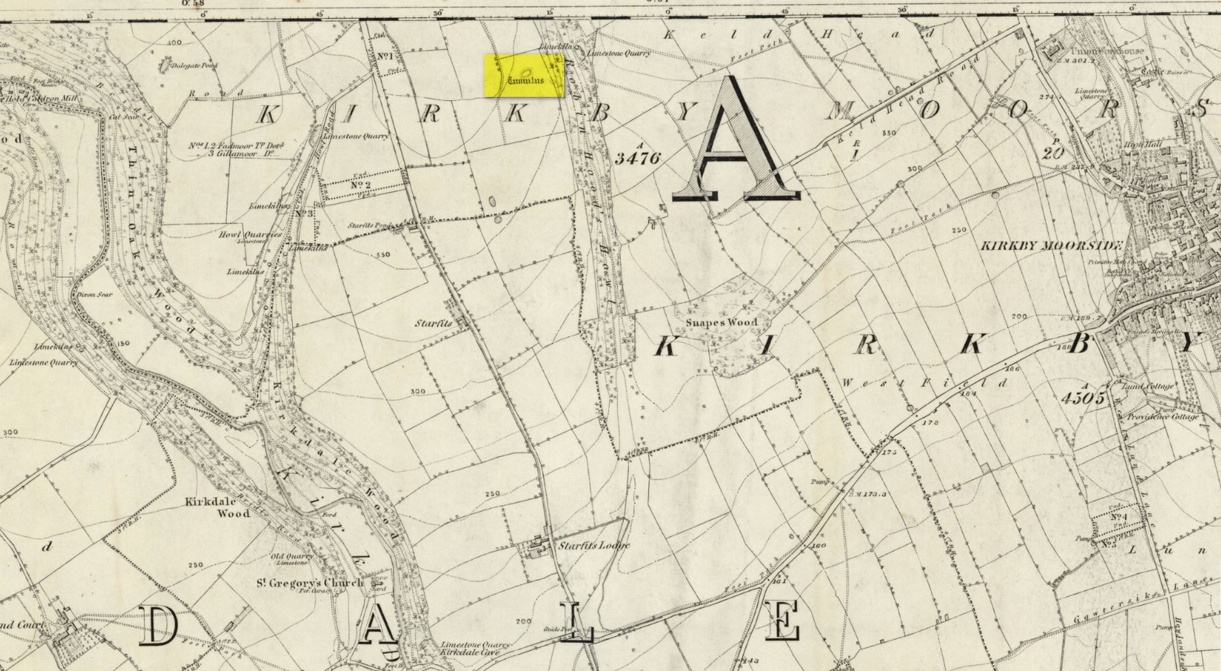
Tumulus (destroyed): OS Grid Reference – SE 6803 8695
Also Known as:
Robin Hood’s Howl
Archaeology & History
Site on the 1856 OS-map
There once stood a very impressive prehistoric burial mound here, a few hundred yards east of the roadside, just above the wooded valley known curiously as Robin Hood’s Howl. Highlighted on the 1856 Ordnance Survey map as an elongated structure, it was suggested in McDonnell’s (1963) work to have been a long barrow, measuring roughly 70 feet long by 50 feet across and more than six feet in height. It was seemingly written about for the first time by William Eastmead (1824) in his lengthy history of the area and was, he told,
“a tumulus of considerable dimensions (that) was lately opened at a place called the Hag, about a mile northwest of Kirkby-Moorside, in which was found an urn… Great numbers of human bones were also dug out…; and from the immense size of it, a great number of bodies appear to have been burnt indiscriminately, and the ashes of some particular person deposited in the urn.”
The urn would seem to have been either lost or destroyed—as has the tumulus. It was apparently still intact, albeit very denuded, twenty years ago, but has since been ploughed out.
References:
Eastmead, William, Historia Rievallensis: containing the history of Kirkby Moorside, R. Peat: Thirsk 1824.
McDonnell, J. (ed.), History of Helmsley, Rievaulx and District, Stonegate: York 1963.
Acknowledgements:Huge thanks for use of the Ordnance Survey map in this site profile, reproduced with the kind permission of the National Library of Scotland.
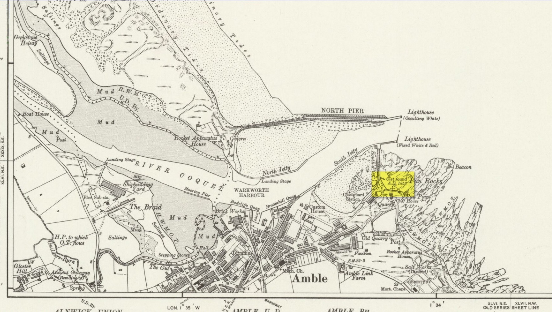
Tumuli (destroyed): OS Grid Reference – NU 273 046
Archaeology & History
In a lengthy letter describing the cist burial at Cliff House, its author, Mr W. Dunn (1857) told that there were additional prehistoric remains nearby, that had only recently been destroyed. He told:
“It appears that, a few years ago, in the immediate proximity of the present discovery (at Cliff House, Ed.) two or more tumuli were found which contained urns and bones; and flint arrow heads of elaborate finish have been occasionally met with.”
I can find no additional information about these sites.
In the same article, a Mr Kell told that during the construction of the Amble piers a half-mile to the west, “some years ago, he was sojourning in the neighbourhood, and …human remains were found on the removal of sand by the waves in a violent gale from the East.” What else is known of this place?
References:
Dunn, W., “Ancient Sepulchral Remains,” in Proceedings Society of Antiquaries Newcastle-upon-Tyne, volume 1, no.34, 1857.
Cist (destroyed): OS Grid Reference – NU 2730 0486
Archaeology & History
Site location on 1926 map
In November 1857, Collingwood Bruce read out a paper that had been sent to him by the Rector of Warkworth village (Rev. W. Dunn), describing “ancient sepulchral remains” that had been found near the cliff-edge above Pan Rocks near Amble’s lighthouse. It was a lengthy account which, in passing, also mentioned several other prehistoric sites close by that have long since been destroyed and which we have very little information about. Mr Dunn’s (1857) letter told:
“In the middle of April last, about 50 yards NE of the Cliff House, Amble, and about 20 yards from the end of what is called Warkworth South Pier, the pilots came upon a long upright stone, standing out of the shale to the height of twelve or fourteen inches,which had been laid bare by the recent heavy gales, but which, from its rude appearance, did not afford the idea of anything beyond a mere accidental tilting. Alongside this upright stone was a large unwrought slab, which, on being raised, was found to be the covering of a cist or sepulchral chamber containing a perfect skeleton. The figure was lying on its left side, with the head to the south-west, having the knees much doubled and with the right arm thrown back. By its side stood an urn of unbaked clay. This urn, now in the Museum of the Duke of Northumberland, resembles in size and shape that which was found a few years since at Hawkhill, and which is preserved in the Museum of the Antiquarian Society of Newcastle. It contained a small quantity of dark earth.
“Having given this general outline of the discovery, I shall proceed to offer such observations as I have been able to make,and have considered worth recording. I grieve to say that before the period of my visit the spoiler had been busy with these venerable remains. The skull had been broken up, the jaws smashed, every tooth appropriated, and the bones indiscriminately mingled, after many a century of undisturbed repose.
“The cist or chamber containing the remains was composed of four slabs inserted edge-wise in a cavity which appeared to have been dug out of the friable shale which lies upon the harder rock in this locality. It ranged south-east and north-west, and measured as follows: depth, 18½ inches; width, 26 inches; length at bottom, 4 feet; at top, 3 ft 4 in.; the difference between top and bottom measurements being accounted for by the shrinking of the ends. The cavity in the shale was much larger than the cist, and the space between the slabs and the shale was closely filled-in with stones, roughly broken, commingled with earth and larger stones. The side slabs projected somewhat beyond the ends. The bottom of the cist was covered to the depth of about half an inch, with dark, unctuous mould. Amongst the rubbish comprising the filling-up of the space above-mentioned, was found an angular piece of silex, probably an unfinished arrowhead; and in the south-west corner of the cist lay a large, smooth cobble stone, which, when considered in conjunction with the flint flake, the imagination may easily construe into the club of this ancient denizen of our shores. The slab which constituted the cover of the cist was of great size and extended in every direction considerably beyond it; and the upright stone was set up, not at one of the ends, but along its length. It is remarkable that a close inspection of these stones gave no trace of chisel-marks in any part. In order that the cover might lie level, pieces of shale, flags, etc., were laid on the uprights which formed the cist, wherever an irregularity presented itself.
“Within the memory of man, the rock ran out from this point for some yards into the sea at a considerable elevation; but the construction of a pier in the immediate neighbourhood has caused the removal of much of the stone, and the spray of our wild sea waves now dashes over the spot which for countless generations may have been peacefully tenanted by these nameless bones. At the same time, it does not appear probable that at any period there has been at this particular point a very deep covering of the sand and bent-grass which are found thick and rank upon the adjacent links.
“The skull must have been very characteristic, having attracted general observation from the extraordinary lowness of the frontal region, the great development of the occipital portion of the head, and the width and length of the lower jaw from its anterior junction to the articulation of the temporal bone. One person observed that during life the man “must have measured as much to the top of his eyebrows as to the top of his head.” The teeth are said to have been very beautiful and regular, and quite sound. With the exception of a front tooth, which was missing in the lower jaw, they were perfect. The thigh-bone measured 19½ inches, indicating a man of large size; whilst the porous internal organization of the bones gave probable evidence of comparative youth.
“The urn is unbaked, of a light clay colour, and measures in height 8 inches, in depth 7¼ inches, and in diameter 5½ inches. It is ornamented with zigzag scoring, alternating with dotted lines,and upright (and sometimes slanting) scorings, which appear to have been made with some rude instrument whilst the clay was moist. The scorings are continued over the edge of the rim. On being rather roughly seized by one of the men, it being expected that it contained treasure, a piece was broken off; but no material injury has been occasioned. The stone found in the cist does not resemble any that one may pick up on the neighbouring shore, and attracted attention from its bearing no assignable relation to what I may call the masonry of the tomb. I have since learnt that stones are not infrequently found in Teutonic graves on the Continent, and that recently a singular oval stone was found in a tumulus on Petersfield Heath.”
All trace of this site has disappeared. Mr Bruce posited the idea that the round stone in the cist may have been the one that ended the life of the buried man! An intriguing thought. And that the urn “no doubt, contained some portion of the feast prepared on the occasion of his funeral.”
References:
Dunn, W., “Ancient Sepulchral Remains,” in Proceedings Society of Antiquaries Newcastle-upon-Tyne, volume 1, no.34, 1857.
Cup-Marked Stone (lost): OS Grid Reference – NO 3975 3340
Also Known as:
Magdalen’s Kirkton Stone
Archaeology & History
In the mid-1890s, workmen ploughing one of the fields near the steading at Magdalen’s Kirkton farm hit a large stone beneath the soil. It turned out to be the covering stone of a prehistoric burial, or cist, that was aligned east-west. Whilst the remains in the cist had all but turned to dust, the covering stone had a number of cupmarks on it. It was described only briefly by R.N. Kerr (1896), who told that,
“The stone forming the lid of the cist is cup-marked. It weighs 5 cwt., 1 qr., 21½ lbs., and its thickness varies from 9 to 12 inches. There are 40 or more cup-markings on it, varying from 1 to 3 inches in diameter.”
It would seem that no sketches were made of this carving and I’ve been unable to find any more details about it. Help!
A small and seemingly prehistoric grave, or cist, destroyed sometime around 1840, once existed on the top of a large hillock close to the River Carron where the bridge leads from Dunipace to Denny. Thankfully, memory of its existence was preserved by Robert Watson (1845) in his short description of Dunipace parish. He first began by talking of some large natural mounds on the eastern side of the township which, folklore told, gave rise to the place-name Dunipace; but from those mounds,
“About two miles to the westward of these hills, there was a very beautiful one about forty feet in height, and covering nearly three roods of ground, said also to be artificial. This hill was mutilated, from time to time, for the purpose of repairing roads and other purposes. It was entirely removed about six years ago, to form an embankment on the turnpike road near Denny bridge. The strata of which this hill was composed, were carefully observed during its removal. These were so regular, and as if rising out of, and gradually returning again to similar strata in the circumjacent level ground, as to afford conclusive evidence that the hill was not the work of man. On the top of this hill, and about three feet below the surface, was found a coffin or tomb, composed of five large un wrought stones, in which were the bones of a human body, scull and teeth not much decayed. Along with these, was a vase of coarse unglazed earthenware, containing a small quantity of material resembling the lining of a wasp’s nest, probably decayed paper or parchment, which in the lapse of ages had assumed that appearance. No conjecture could be formed about the individual here interred, tradition being entirely silent on the subject ; but this circumstance corroborates the opinion of some writers, that the hills of Dunipace might have been used as burying-places for ancient chiefs.”
The site was included in the Royal Commission’s (1963:1) Inventory, but they found no additional data about it.
References:
Royal Commission on the Ancient & Historical Monuments Scotland, Stirling – volume 1, HMSO: Edinburgh 1963.
Royal Commission on the Ancient & Historical Monuments of Scotland, Archaeological Sites and Monuments of Stirling District, Central Region, Society of Antiquaries of Scotland 1979.
Watson, Robert, “Parish of Dunipace,” in New Statistical Account of Scotland – volume 8, William Blackwood: Edinburgh 1845.
Tumulus (destroyed): OS Grid Reference – SE 234 336
Archaeology & History
Today, Hough Hill has almost completely given way to modern housing; but in bygone centuries, this hilltop once housed a prehistoric burial mound—albeit an inconspicuous one. It was mentioned briefly in Faull & Morehouse’s (1981) magnum opus, but we know very little of its overall appearance and stature. Its existence was recorded posthumously thanks to the antiquarian John Holmes, without whose notes it would have been lost to history.
During quarrying operations at Hough Hill in December 1879, an ornamental urn was found,
“filled with calcined bones (that) was placed on a dish shaped hollow, some two or three feet deep, with charcoal and burnt earth.”
Holmes compared some markings that were upon this urn to one that was uncovered in Acrehowe Hill above Baildon by J.N.M. Coll in 1845. Unfortunately the Hough Hill urn was broken into fragments shortly after being uncovered. All remains of the burial mound have been completely destroyed.
References:
Faull, M.L. & Moorhouse, S.A. (eds.), West Yorkshire: An Archaeological Guide to AD 1500– volume 1, WYMCC: Wakefield 1981.
Holmes. John, “A Sketch of the Pre-Historic Remains of Rombalds Moor,” in Proceedings of the Yorkshire Geological & Polytechnic Society, volume 9, 1886.
Wardell, James, Historical Notes of Ilkley, Rombald’s Moor, Baildon Common, and other Matters of the British and Roman Periods, Joseph Dodgson: Leeds 1869. (2nd edition 1881).
Were it not for the valuable records in the Scottish Statistical Accounts, we’d have lost all knowledge of this site. It was described in notes by by Colin Baxter (1793), where he told us:
“About 200 yards west from the church of Monivaird, a barrow was opened some years ago, in which two urns were found, each containing a stone of a bluish colour, very hard about four inches long, and of a triangular shape, somewhat resembling the head of an axe.”
The site was subsequently mentioned in the Ordnance Survey Name Book of the parish, with some additional bits of information:
“In the year 17–, there was found, about one hundred yards to the westward of the old church of Monzievaird, a barrow containing a stone-coffin, in which were inclosed two coarse earthen urns, the one filled with burnt bones, the other containing the bones of the head. Of these, the under jawbone and the teeth were very entire. In the stone coffin was also found a stone hatchet, bluish-coloured, very hard, about four inches long, and of a triangular shape, a remain which proves the barrow of very remote antiquity – prior to the use of iron. The stone hatchet is preserved at Ochtertyre.”
No traces remain of the site; and although the stone axes came to be in the possession of Sir William Murray of Ochtertyre, the urns and other remains have long since been lost.
Folklore
The name of ‘St Serf’s Water’ derives from it this area being dedicated to St Servanus in early times; the holy well of St Serf could be found a short distance south from where this tomb was built.
References:
Baxter, Colin, “United Parishes of Monivaird and Strowan,” in Statistical Account of Scotland – volume 8, William Creech: Edinburgh 1793.
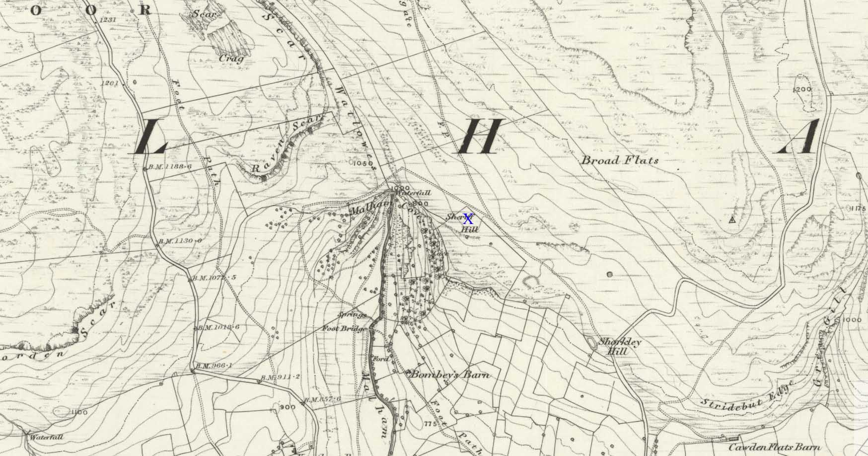
There’s nowhere to park any vehicles anywhere near this place if you wanna reach this site. And so, from Malham village, take steep eastern road up Malham Rakes (ask a local if needs be) for exaclt half-a-mile (0.81 km) where, at a bittova sharp turn in the road, there’s a footpath on your left. Walk along here for about 350 yards until you hit a straight line of walling on your left. Follow this along, about 30 yards before it turns at a right-angle. On the other side of the wall from here, a barely discernible denuded heap is in the overgrown field. That’s it!
Archaeology & History
To be found above the grand rise of Malham Cove—on its eastern side—the earliest mention I’ve found of this once-large prehistoric burial cairn was in the Cravendale travelogue of William Howson (1850). His description was only a brief one, telling us how,
“The workmen engaged on the fences have lately opened a large barrow, which is known by the local as the Friars’ Heap, near the eastern arm of the Cove, and a quantity of human bones were found.”
In Howson’s opinion he thought “the spot is much more likely to be connected with the marauding Scots than the peaceful monks”; but he was wrong on both counts. When the site was later visited and described by the great northern antiquarian, Harry Speight – aka, Johnnie Gray (1891) – he told us that the place “was much more likely to have been a British or Danish burial mound.”
Originally standing to a height of more than six-feet, the tomb has subsequently been reduced to half that height. The most lengthy descriptions of it were written by the regional antiquarian Arthur Raistrick. In his topographical literary meanderings across the Malham landscape, he gives a fine overview of its features and locale:
“Across the clints the old valley which leads to the edge of the Cove is seen, and looking upstream a grand impression of the Dry Valley, properly called Watlowes, is obtained. Across the foot of the valley a stile crosses rhe wall, and a footpath goes up the hill near to the boundary wall of the Cove; this is Sheriff Hill. At the prominent corner of the wall where the path resumes a level course, it joins the path from Malham Lings called Trougate. Between here and the road there are abundant traces of the Celtic fields, nestling under the small limestone crags that offer shelter from the northeast, evidently as unwelcome a quarter for the wind when these were occupied as today. Where the wall turns at right-angles again towards the Cove, there is a very prominent circular mound nearly a hundred feet in diameter. This is a burial mound of late Iron Age. It was dug into about the year 1845 and in addition to many human bones , fragments of an iron spearhead were found. It is to be regretted that no careful account of this excavation was preserved, as there seems no doubt that this was a multiple burial of some importance. Like other burial mounds in this district, the site was well chosen with a most extensive view which includes many notable hill summits…”
This latter remark could well have come from the pen of the old ley-hunter, Alfred Watkins (1925), who noted time and again how landscape features would seemingly connect one site with another, and another. (the modern idea of leys as ‘energy-lines’ is an American invention and wholly without merit)
A few years after Raistrick gave us his initial description, the cairn was excavated. In his short work on the archaeology of Malham Moor (1961), he wrote:
“A burial mound (that was) three-quarters removed at the time of the enclosures (about 1845) when the mound was dug as a quarry for walling stones. The remaining fragment was trenched right through and was found to be built entirely of stone with a kerb of large flaggy stone laid on the slope at the foot of the mound. Many fragments of decorated pottery were founmd under the turf cover and were associated with what appeared to be discarded gravel from the original quarrying, so may have come from the centre. At the inner edge of the kerb and under a carefully placed cover-stone, a smal oval vessel was got. This is of thick bluey-grey paste, red outside and very flaky so that part of the surface is lost on the two-thirds of the vessel which remains. Prof Stuart Piggott has reported on the pottery. Of this vessel he says — “an oval cup of the so-called ‘Incense Cup’ class: one sherd is of the wall and base of one end, the other a piece spalled off from the inside of the base. I only know of one paralle to this remarkable pot, another oval incense-cup from Far Fields, Lockton, N.R. Yorks, in the York Museum. A very odd little oval ‘cup’ of sandstone from Defford, Bredon, Worcs, in the Hastings Muesum at Worcerster is a stray find and might be of any age, and anyway only provides a vague parallel.”
Another “vessel is represented by sherd of what appears to be a small cinerary urn of collared or overhanging-rim type with the yellow-brown surface characteristic of so many pots of this class. The decoration appears to be in alternating panels of vertical and horizontal lines of uncertain width, the whole forming the so-called ‘hurdle’ pattern. The ornament is made of double lines of twisted cord, one with a right-hand and the other with a left-and twist: such ornament is widely distributed on such vessels…
“A third “vessel is represented by a few sherds with purple-red exterior, decorated with impressed cord, whipped cord and grooving. It is diffcitul to say what sort of pot is represented, but I suspect something within the food vessel class… The whole assemblage could well be contemporary and would fall withini the Middle Bronze Age of conventional nomenclature, somwhat in the middle of the second millenium BC…”
The most striking feature of this site is its position in the landscape, typical of large cairns in the Pennines and much further afield. The view to the south is extensive and would have had some bearing on its construction, as such heights allow for the spirits of the dead to move across the landscape. The huge cliffs of Malham Cove below may also have been an important factor. In the days when this tomb was built, a great waterfall existed at the Cove that has subsequently fallen back to Earth. In many traditional cultures, water is an extremely important element. Its relationship to life is obvious; but also in the Lands of the Dead water feeds the spirit on its journeys. These animistic and geomantic features are essential in looking at the nature of the placement of sites—and this at Sheriff Hill would have been no exception.
Enjoy your sojourns and meditations here…
References:
Gray, Johnnie, Airedale, from Goole to Malham, 1891.
Howson, William, An Illustrated Guide to the Curiosities of Craven, Whittaker: London 1850.
Raistrick, Arthur, Malham and Malham Moor, Dalesman: Clapham 1947.
Raistrick, Arthur & Holmes, Paul F., Archaeology of Malham Moor, Headley Bros: London 1961.
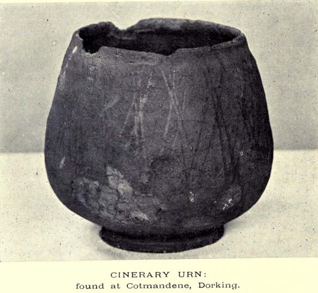
Tumulus (destroyed): OS Grid Reference – TQ 1686 4958
The Cotmandene urn
Archaeology & History
Highlighted on the 1914 OS-map (as ‘Site of’), nothing now remains of the prehistoric structure that either covered or surrounded the ancient burial urn, found fortuitously by a Mr Turner in the garden of Southdown Cottage at the beginning of the 20th century. Believed to be either Iron Age or Romano-British in origin, the find was noted by Mr Malden (1913) in his brief in the Surrey ArchaeologicalCollections, who wrote:
“Early in 1913 it came to my knowledge that some years ago some discoveries had been made in the garden of a house on Cotmandene, Dorking. Mr Turner…was digging for sand in his garden when he found a small cinerary urn (see illustration), with ashes in it. The height is only 5 inches, the diameter across the top about 4 inches, but at the widest part 5⅜. The urn is so small that it probably contained the ashes of a child: it is wheel-made, but badly; the diameter is not precisely the same across the top from every direction: Mr Reginald Smith attributes it to the first century BC. Some fragments of other urns were found. Mr Turner has kindly presented the whole specimen to the Society’s Museum. At a lower depth in the same garden were numerous flints, some implements, many flakes, and traces of a hearth with several burnt stones. These clearly belonged to an earlier date, considerably, than the interments, but as the finds were made about 1906-7, and not investigated till this year, it is impossible to be precise about the depth at which they occurred.”
References:
Malden, H.E., “A Cinerary Urn and other Matters found at Dorking and Betchforth,” in Surrey Archaeological Collections, volume 26, 1913.
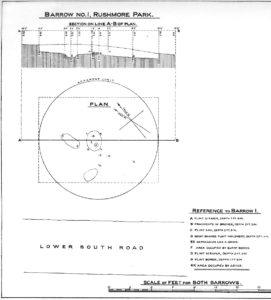
In what today seems a barely visible tumulus, amidst the large cluster that could once be found upon the large estate grounds of Rushmore House, were once the overgrown ruins of an old tumulus. It seems to have been rediscovered in the 19th century, when the legendary antiquarian, General Pitt-Rivers, moved onto the huge estate. It was all but hidden even in his day, he told, but being “of such slight elevation that, like many others, it had never been noticed.” It was the first of all the barrows they excavated on his Estate, and is to be found “near the house on the south side of the lower south coach road.”
So, in 1880, he got some of the estate lads to help him and Rolleston start a dig into the old tomb – and they weren’t to be disappointed. It wasn’t anything special, but it was the first amongst many hereby. In Pitt-River’s (1888) massive tome on the prehistory of the region, he told us:
“This was the first barrow opened at Rushmore, on the 10th August, 1880. Professor Rolleston and the Rev. H. Winwood were present at the opening. The elevation was so slight that it had hitherto escaped notice. In the centre, 1 foot 6 inches beneath the crest, a layer of charcoal and ashes, 9 feet by 6 feet, was found containing a burnt body. The body appears to have been burnt on the spot, and not gathered up after cremation, but a mound raised over the funereal pile. A few fragments of bronze, probably the remains of some implement which had corroded or been burnt, were found in the ashes, and in the body of the barrow two flint scrapers, a well-formed flint borer, and a boat-shaped flint…were found (see illustration above, PB). A few scattered fragments of pottery found in the barrow were of a superior and harder baked quality than is usual in barrows. No trace of a ditch was found around the barrow, but towards the north of the centre, a depression—EE on plan—which might, or might not, have been a grave, but filled with mould and without remains, was discovered. The barrow is undoubtedly of the Bronze Age, and is interesting on account of it being the last at the opening of which Professor Rolleston assisted shortly before his death.”
As a result of this, he decided to name to barrow after his old friend and also planted a beech tree on top of it in remembrance of him.