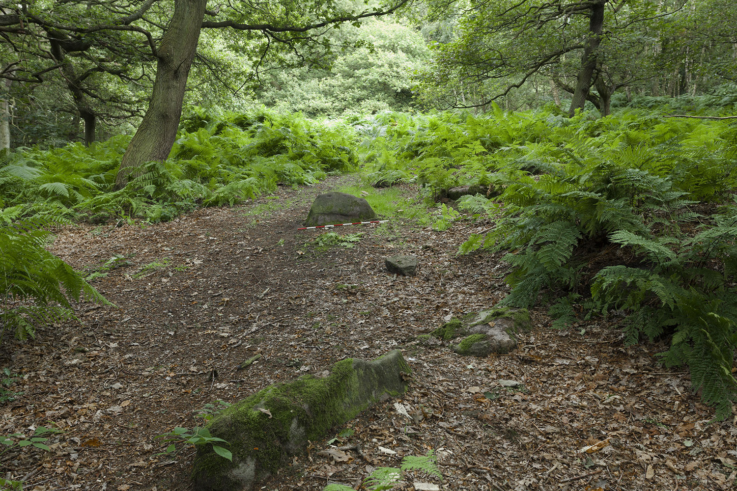
Mike Short tells: Walk ENE along Thornhill Drive (no vehicular access) to gate across road at the last house on the Drive and continue on for approx 475m where road starts to narrow slightly, becomes a little steeper and gently turns to E. Thornhill Drive is now cut into the hillside at this point with an upwards sloping bank on the S side of the path. After approx 25m further on at approx SE 20375 37950 look out on the S side of the path for a pile of boulders sitting on bedrock on top of the bank and a large rectangular tabular rock on the side of the bank. Ascend the bank and from the boulder pile the panel is approx 22m 200º(T) in the middle of an ephemeral E-W path more defined to W.
Archaeology & History
The profile (and ‘How to Get There’) for this recently discovered cup-marked stone was forwarded to me by fellow rock art explorer, Mike Short. The carving is another basic design found in Calverley Woods, between Leeds and Bradford, nearly halfway between the missing petroglyphs of West Woods 2 and Sidney Jackson’s Calverley Woods Stone. Rediscovered by Lisa Volichenko some time ago, Mike described the new carving here as follows:
Sketch of the carving (courtesy Mike Short)Cup-Marked Stone nr centre (courtesy Mike Short)
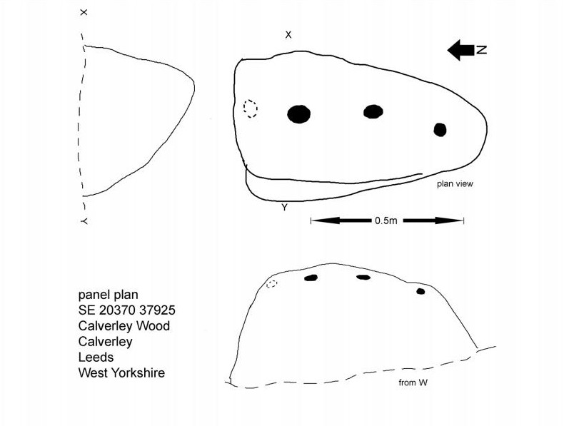
“Panel is carved on W sloping face of a sub-triangular earthfast coarse-grained sandstone boulder 0.81m X 0.50m X 0.38m, the longest axis lying almost exactly N-S. Carving consists of 3 cups, the most N of which is elliptical approx 65mm X 55mm; the central cup is elliptical approx 50mm X 40mm and the most S is circular diameter approx 40mm. On the N edge of the W face is a shallow elliptical depression thought to be of natural origin. There is an area of damage along the ‘crest’ of the boulder close to its S end.
“Carved rock is the most E of five rocks, measuring between 0.70m and 1.15m in length, in very close proximity forming an arc, 3 of which are in the footpath and one of which is resting on a large slab of rock almost completely covered by soil and vegetation.”
And so the small number of cup-marked stones in this woodland slowly grows. One wonders how many more are hidden beneath the roots of the trees—and are all of the lines and cups atop of the great Hanging Stone, a short distant away, all Nature’s handiwork…?
Acknowledgements: Huge thanks for Mike Short for the data, photos and sketch of this carving.
Although now seemingly lost, it’s location is damn close to this: Along the A657 between Greengates and Bradford, where the New Line meets Carr Road, the dirt-track takes you into Calverley Woods, down Eleanor Drive. About 250 yards along (just before you get to the field on the left), take the footpath down the embankment towards the stream where it bends to the left and where the land levels out (don’t cross the stream). It’s somewhere round there!
Archaeology & History
This was one of two previously unrecognised carvings we came across sometime in 1985 (see West Woods 1 stone), when we were seeking out another missing carving in the same woods. It was clear and well-defined as the faded photo here shows; but having been back to try find it twice in the last two years in the hope of getting better photos, I’ve been unable to locate it. The carving was described in an article I did in an old earth mysteries magazine. It comprises simply of a large ring surrounding and enclosing two deep cups, which were linked to each other by a connecting carved line. Parts of the stone had been chipped in parts—including a section of the large ring— due to some industrial workings that had happened here in the past. Thankfully I managed to find the old photo and hopefully, perhaps, some local explorer could try and seek out where it’s hiding beneath the trees and other vegetation.
References:
Bennett, Paul, “The Undiscovered Old Stones of Calverley Woods,” in Earth no.2, 1986.
On the A657 road, a half-mile past Greengates towards Calverley, just before the road starts going uphill, take the lower dirt-track of Eleanor Drive on your left into Calverley Woods (here known as West Woods). About 150 yards along the track, note the small footpath on the right which goes up diagonally further into the trees. Go along here until you reach the remains of a dried-up pond on your left. The carved stone is about 10 yards before the pond, just above the footpath.
Archaeology & History
Rubbing of the 2 cupmarks
Another stone only for the puritans amongst you! This (and the West Woods 2 carving) was one we found in 1985 when we were exploring the woods looking for the Calverley Woods cup-marked stone reported by Sid Jackson in the 1950s. The stone is a small roughly oblong, earthfast rock, about 2ft by 1ft across, and has two distinct but faded cup-marks on its slightly sloping face. That’s it!
Soon after first finding this, we made a couple or rubbings of the stone, one of which I reproduce here and which shows the two cup-marks. You’ll note the measurement and note of the cups being 2 megalithic inches (MI) in diameter. The MI was a statistical unit of measure suggested by the late great Alexander Thom, who found regular integers of 2.07cm in many of the cup-and-rings he examined, and so surmised it as a deliberate numeric system. At the time when we found this cup-marked stone, I was exploring Thom’s idea and was very much taken up with it. However, after a few years doings numerous rubbings of the many cup-and-ring stones in West Yorkshire, and exploring the simple size of the human hand and how we execute cup-markings on rocks, I found Thom’s idea didn’t seem to be realistic. (though I still love Thom’s works: the man was an outstanding researcher, far exceeding all the archaeologists of his period in terms of his exploratory methods)
References:
Bennett, Paul, “The Undiscovered Old Stones of Calverley Woods,” in Earth 2, 1986.
Troublesome really, as it’s got lost somewhere amidst the undergrowth. From the valley bottom at Apperley Bridge, take the road-then-track which goes up thru the Calverley Cutting (as locals call it), turning left along the dirt-track just as the track begins to slope uphill. Go past the detached house in the edge of the trees and shortly past there is a small footpath taking you into the trees on your left, Walk down and along here, near the bottom of the tree-line above the walling. If you find it, let us know!
Archaeology & History
Included in Boughey & Vickerman’s (2003) survey as ‘stone 12’ – it was first described by Sidney Jackson in 1954, who later gave us a map and drawing of the stone. I looked for it several times x-number of years back, but never found it (though was led astray a little by the profusion of Amanitas in the locale!). Comprising at least 18 cup-markings on a generally flat rock surface, to this day the carving remains unfound, though is probably under the herbage hereabouts. The same fate seems to have befallen the West Woods 1 and West Woods 2 carvings in another part of the same woods. Does anyone know what’s become of them?
References:
Bennett, Paul, “The Undiscovered Old Stones of Calverley Woods,” in Earth no.2, 1986.
Boughey, Keith & Vickerman, E.A., Prehistoric Rock Art of the West Riding, West Yorkshire Archaeology Service 2003.
Jackson, Sidney (ed.), ‘Calverley Wood Cup-Marked Rock,’ in Bradford Cartwright Hall Archaeology Group Bulletin, 1:1, 1954.
Jackson, Sidney (ed.), ‘Cup-Marked Boulder in Calverley Wood,’ in Bradford Cartwright Hall Archaeology Group Bulletin, 1:7, 1955.
Jackson, Sidney (ed.), ‘Cup-and-Ring Boulders near Calverley,’ in Bradford Cartwright Hall Archaeology Group Bulletin, 1:16, 1956.
Take the A658 road north out of Bradford, past Undercliffe, and downhill towards Greengates. When you meet with the large junction where Ravenscliffe Avenue turns to your right – stop! Immediately on the left-hand side of the road is where the old well used to appear.
Archaeology & History
Old map showing Eccleshill’s Holy Well
In times past this was one of the most renowned holy wells in the region (we have at least 200 in West Yorkshire). First recorded as a holy well in 1585, specialist writer Edna Whelan remembers the waters here running into a stone trough at the side of Harrogate Road when she was young.
In 1932, local historian W.E. Preston described, “the remains of what was once a fine grove of trees leading up the hillside from the road to its source,” implying ritual commemoration and a procession to the site. Today, this grove is still evidenced by the straight footpath across the main road, leading to the infamous Ravenscliffe estate.
In 1704 a court case was brought against some locals – Mr & Mrs Richard and Sarah White (and their daughter, Mary) – “for diverting the water from its ancient channel.”
In 1867 it was described in the Object Name Book:
“A considerable and well-known spring, it has the appearance of having been a bathing place. A bank has been thrown up on the east side, and a broken wall remains on the other sides. There is no tradition about it. It is likely to have been of some note…in the days of Romanism. Large trees are ranged on either side of the approach to it, forming a grove.”
Up till 1978, Andrea Smith (n.d.) reported the well to still be “protected by local tradition,” but this is no longer possible. Yorkshire Water don’t particularly give a damn about its preservation (water is money folks!) and today it’s covered by a man-hole in the garden.
References:
Preston, William E., ‘Notes on the Early History of the Manor of Eccleshill,’ in Bradford Antiquary, 5, 1912.
Preston, William E., ‘Some Local Holy Wells,’ in Bradford Antiquary, June 1932.
Smith, Andrea, ‘Holy Wells Around Leeds, Bradford & Pontefract,’ in Wakefield Historical Journal 9, 1982.
Whelan, Edna & Taylor, Ian, Yorkshire Holy Wells and Sacred Springs, Northern Lights: Pocklington 1989.