Holy Well (lost): OS Grid Reference – NC 725 538 (approximation)
Archaeology & History
It would appear that there’s only one literary reference to this seemingly lost holy well, located halfway down megalithic Strathnaver, somewhere close to the legendary Loch ma Naire. James Horsburgh’s (1870) essay on the antiquities of this area mentioned it, almost in passing, in his description of the Dun Viden broch. He told that,
“Close to Dun Viden is Loch Manaar, where dozens of people come twice every year for the cure of diseases. They come before sunrise, bathe in the loch, walk round it, drink from a holy well (my emphasis), and throw some pieces of money into the loch. There is a legend about this loch, which I forget; but a woman was chased by a priest, and threw something in it, and called out that it was Loch Manaar—that is, the loch of my shame. “
The holy well is referred to in Historic Scotland’s Canmore entry, citing both the New Statistical Account and Name Books as referrals to the site, yet neither of them include this well in their surveys; it is only through Horbugh that we hear of this site—and we know not where it lived! In the event that it still exists, we’d expect it to be not more than 2-300 yards from the edge of Loch ma Naire; or perhaps it may be the source of the Loch ma Naire burn itself, nearly a mile to the east…. Seek and thee shalt find, as the old saying goes…
A long long way to go for a single little spring! From Kirriemuir town centre go up the B956 Kinnordy Road, going straight across at the crossroads up the countryside lane towards Lednathie (signposted 8 miles): dead straight, long-and-winding, up-and-over…. Stick to this single road, all along, ignoring all turn-off junctions until, once reaching the hamlet of Easter Lednathie, stay awake for the turn up to Glenprosen, 2 miles along, over the bridge. Turn left and a few hundred yards along go over the next little bridge until you reach the “Private Road” sign, then walk up the track past Katy’s Cottage. ¾-mile along just before Balnaboth, keep your eyes peeled to the left for a splatter of quartz rocks with a spring of water thereby. At long long last, you’ve reached your destination!
Archaeology & History
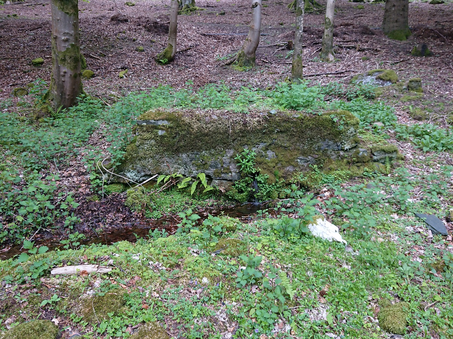
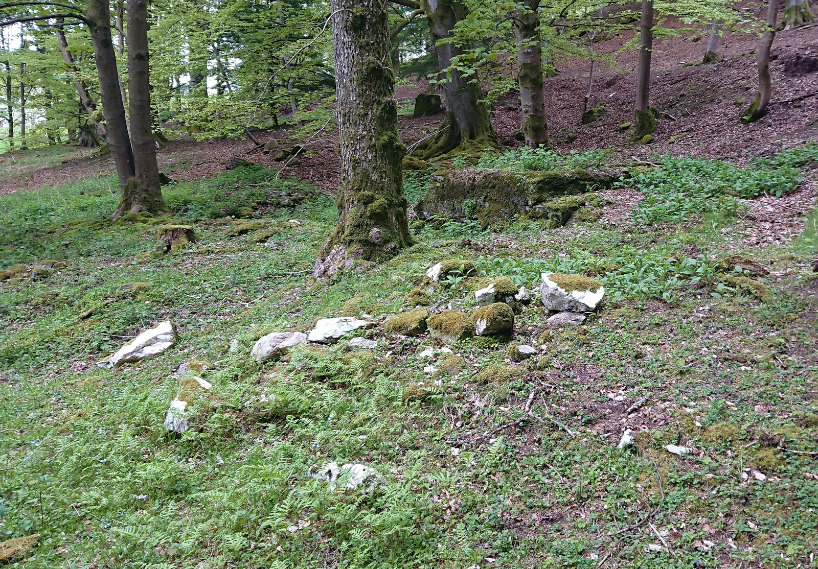
A “splatter of quartz rocks”
Miles to the winding north of Kirriemuir, in the depth of the olde mountains, this clear spring of iron-bearing water (still fresh and drinkable) was, earlier in the 20th century, covered over by someone-or-other and surrounded by straight slabs of stone. The waters were maintained however, by the builders who cut a small hole into the moss-embolded rock allowing this pure water to still run freely for all to use…
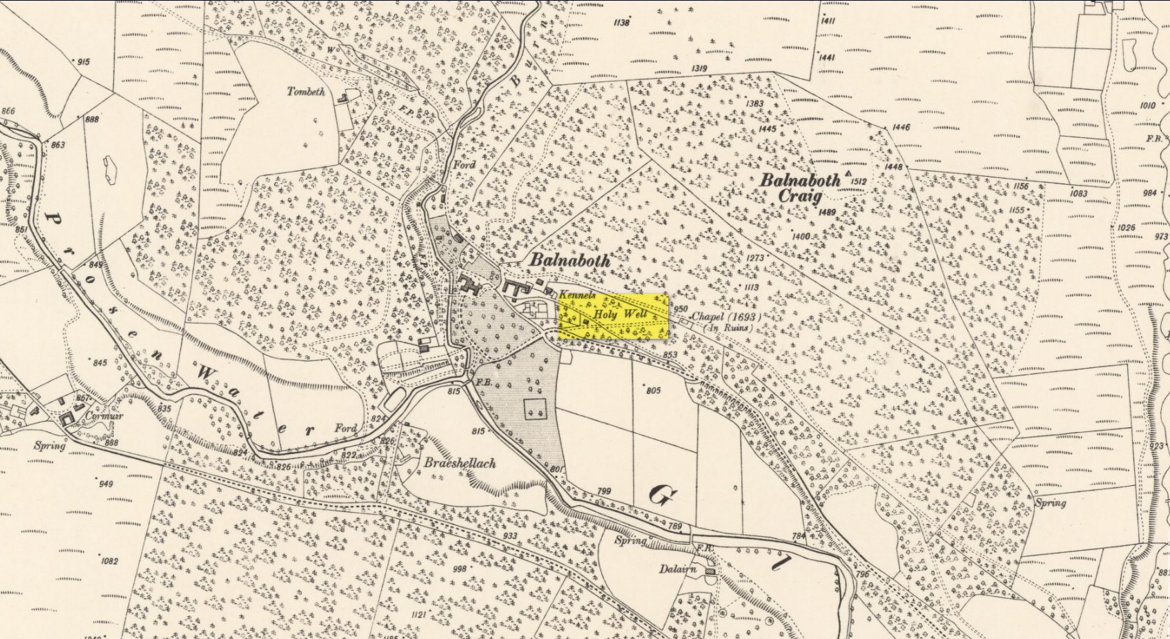
Shown on the early OS-maps, its sacrality or holy association would seem to be lost from the tongues of the older folk, most of whom seem long gone from this beautiful glen-to-nowhere. The only remaining religious connection we might have relating to the place comes from the ruined 17th century chapel less than 250 yards away to the west on the slope above the track, from where a singular stone-lined footpath runs dead straight to the well.
Site shown on 1900 OS-map
But another important feature found here is the large scatter of quartz rocks a few yards away from the water source. They are in disarray but would seem to have once been built around the spring where it first emerged from beneath the ground, then being cast aside to their present positions when the more modern stone structure was built above it. We can’t prove this with any certainty, but there are a number of other holy wells with this quartz-defining feature elsewhere in Scotland: the St Mary’s Well at Callander and Beltane Well of Kenmore to name just two.
References:
Robertson, D.O., Long-Ago Legends of Clova, W.P. Nimmo: Edinburgh 1872.
Acknowledgements:Huge thanks for use of the Ordnance Survey map in this site profile, reproduced with the kind permission of the National Library of Scotland.
Early photo of holy well site (Henry Taylor, 1906)
To get here you have to travel right to the end of the road, then walk a short distance until you hit the horrible coastal waters where there’s a natural rock arch. Just before here, on the west-facing side, is this famous holy well.
Archaeology & History
Just before this little-known sacred well is a cavity in the limestone rock which is called the Fairy Church, and a couple of hundred yards below here is another one which was known as the Fairy Chapel. This region was obviously of sacred importance to our ancestors – and should still be to those of us with ecological concerns. The waters from this well were said to cure poisons from the body. It was written about at some length in Mr Taylor’s (1906) superb survey, where he collated material from a series of other early tracts describing the well. He wrote:
“This celebrated medicinal well is said to have been used by lead miners from the time of the Romans. The patients come for a two or three days’ stay to “get the poison out of their systems.” The site is three and a half miles nearly due south from Cartmel. The water, which has a very peculiar taste, comes down from the hillside and flows into a small artificial basin or grotto. The key of the door is kept at a neighbouring farmhouse. Close to the well is an untenanted building formerly used by indigent sufferers. The wooded cliff forming ‘The Head’ is of singular beauty, overlooking the waters and sands of Morecambe Bay. On Hennet’s map of Lancashire (1828) the well is called ‘Spa Holy Well.’
“…Mr. W. O. Roper, in his Churches, Castles, and Ancient Halls of North Lancashire, writes: “One other appendage to the Priory of Cartmel should be mentioned, and that is the well known as the Holy Well. On the sea-shore, close under the towering cliffs of Humphrey Head, and almost immediately below the natural arch of rock which leads to the recess known as the Fairy Chapel, bubbles the well to which in former days the Priors journeyed in state from their neighbouring Priory, and to which in more recent times large numbers of people resorted, hoping to derive benefit from its medicinal qualities.”
“Mr. James Stockdale, in Annals of Cartmel, writes: “Near to this holy well (Humphrey Head) are two cavities in the mountain limestone rock called the ‘Fairy Church’ and the ‘Fairy Chapel,’ and about three hundred yards to the north there used to be another well, called ‘Pin Well’, into which in superstitious times it was thought indispensiable that all who sought healing by drinking the waters of the holy well should, on passing it, drop a pin; nor was this custom entirely given up till about the year 1804, when the Cartmel Commoners’ Enclosure Commissioners, on making a road to Rougham, covered up this ‘Pin Well’. I have myself long ago seen pins in this well, the offerings, no doubt, of the devotees of that day.”
“Mr. Hope, in his Holy Wells of England, says that “this is a brackish spring celebrated as a remedy for stone, gout, and cutaneous complaints. The water issues from a projecting rock of limestone, called Humphrey Head and its medicinal qualities occasion a considerable influx of company to Cartmel, Flookborough, Kent’s Bank and Grange during the summer months…”
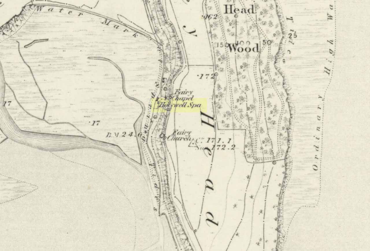
Holy Well on 1851 map
The site was clearly marked in 1851 on the first OS-map of the area as the Holywell Spa, and the attendant Fairy Chapel and Fairy Church shown as two distinctly separate places, very close by.
References:
Hope, Robert Charles, Legendary Lore of the Holy Wells of England, Elliott Stock: London 1893.
Taylor, Henry, The Ancient Crosses and Holy Wells of Lancashire, Sherratt & Hughes: Manchester 1906.
Although this upland loch is today renowned as little more than a decent fishing spot, the waters here were long known to be haunted and the abode of a legendary water spirit. In local tradition, the loch is said to be named after “an ancient Chief of Pictish origin” — whose burial mound is nearby — and in James Kennedy’s (1928) fascinating folklore work he also told that,
“Loch Dereculich was the habitation of a ‘Tarbh Uisge’ (water bull), the dangerous water demon… This dreaded monster, as the Norwegian peasant will gravely assure a traveller, demands every year a human victim, and carries off children who stray too near its abode… Less than one hundred and twenty years ago, the Loch Derculich Water Bull was seen sauntering along its shores. At peat-making times it was observed very frequently.”
References:
Kennedy, James, Folklore and Reminiscences of Strathtay and Grandtully, Munro Press: Perth 1928.
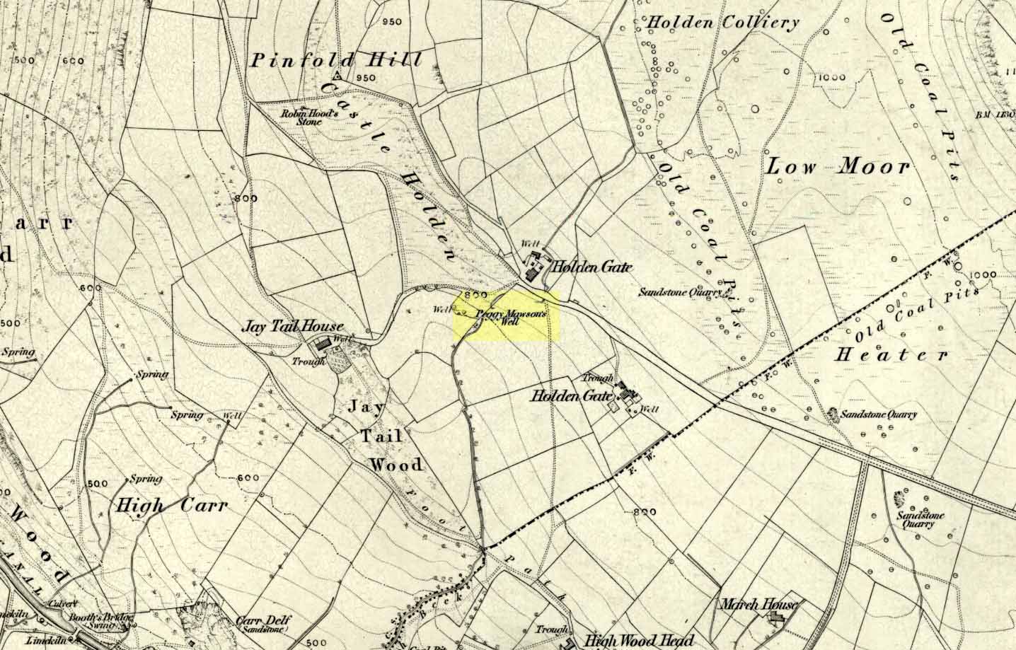
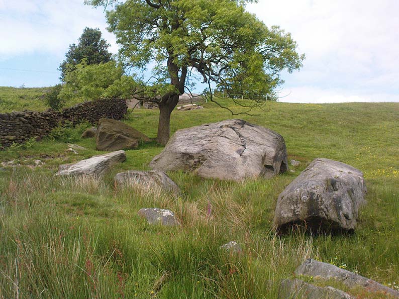
From Riddlesden, take the road up to the moorland and Rivock Edge. When you reach the top (Silsden Road), turn left. Go on for about 600 yards till you reach the lovely tree-hidden old cottages of Holden Gate, on your right. Stop — and walk down the footpath opposite from here. As the wall goes down, you’ll notice a stream in the next field to your left, emerging from a clump of large rocks. That’s it! (there’s a footpath in the next field from the roadside)
Archaeology & History
Shown on the first OS-map as ‘Peggy Mawson’s Well,’ little else seems to known of this place; though it obviously got its name after the local lady, Peggy Mawson. I can find no further information about this lady, nor why the site was named after her. Any help here would be hugely appreciated!
Peggy Mawson’s Well – now drained-off through pipes
Sadly the waters from beneath the rocks have been channeled into a couple of pipes and the well no longer runs. All that’s left is a small boggy region just in front of the boulders. You have to walk about 100 yards further down the field where the water emerges from a modern pipe. It doesn’t taste as nice as it originally did when coming straight from the ground, but it’s still quite drinkable (certainly beats any of the chlorinated stuff* that customers are forced to pay for, whether we want it or not – and most people don’t want it).
Folklore
This site has acquired modern folklore, but sadly no early traditions have been found. Whelan & Taylor (1989) thought that Peggy Well’s “dedication suggests a connection with St. Margaret,” which unfortunately isn’t the case. Several years later another writer, Val Shepherd (1994), spun the speculation even further, not checking the historical background to the site, and thought that “the well’s name may be derived from the water spirit, ‘Peg,’ who gave her name to other wells.” Sadly neither idea holds any sway.
References:
Shepherd, Val, Historic Wells in and Around Bradford, HOAP: Loughborough 1994.
Whelan, Edna & Taylor, Ian, Yorkshire Holy Wells and Sacred Springs, Northern Lights: Pocklington 1989.
* Anyone know about this: surely because the water companies chlorinate and add other undesirable toxins into our tap water, what we’re actually drinking is a very weak solution and not actually water. Isn’t that a trading standards violation?
From Bingley, take the B6429 road up to Harden. After going up the wooded winding road for a few hundred yards, stop where it levels out. Cross onto the right-hand side of the road and walk up the slope a little, veering to your right. You’ll notice a small disused building just off the roadside, in overgrowth, with a pool of water. You need to be about 100 yards up the slope above it!
Archaeology & History
Elm Crag Well, Bell Bank Wood, Bingley
This is a beautiful old place. If you walk straight up to it from the roadside, past the derelict building, you have to struggle through the brambles and prickly slope like we did – but it’s worth it if you like your wells! However, if you try getting here in the summertime, expect to be attacked on all sides by the indigenous flora! The waters here emerge from a low dark cave, in which, a century of three ago, someone placed a large stone trough. When I first came here about 25 years ago, some halfwits had built an ugly red-brick wall into the cave which, thankfully, someone has had the sense to destroy and rip-out.
Shown on the 1852 Ordnance Survey map and highlighted as a ‘spring,’ Harry Speight (1898) gives a brief mention to this site, though refers us to an even earlier literary source when it was first mentioned. In John Richardson’s 18th century survey of the Craven area, he makes reference to an exceedingly rare fern, Trichomanes radicans, which was later included in Bolton’s classic monograph on British ferns of 1785. In it, Bolton wrote that the very first specimen of this plant was “first discovered by Dr. Richardson in a little dark cavern, under a dripping rock, below the spring of Elm Crag Well, in Bell Bank.”
Elm Crag Well
The waters from here come from two sides inside the small cave and no longer run into the lichen-encrusted trough, seemingly just dropping down to Earth and re-emerging halfway down the hillside. But the waters here taste absolutely gorgeous and are very refreshing indeed! And the old elms which gave this old well its name can still be seen, only just hanging on to the rocks above and to the side, with not much time left for the dear things.
References:
Bolton, James, Filices Britannicae: An History of the British Proper Ferns, Thomas Wright 1785.
Speight, Harry, Chronicles and Stories of Old Bingley, Elliott Stock: London 1898.