Cup-and-Ring Stone: OS Grid Reference – SO 9875 2825
Archaeology & History
Nottingham Hill cup-and-ring
A rare find this! In October 1981, in deepest Gloucestershire on the edge of the Nottingham Hill Iron Age hillfort, archaeologists sifting through what they ostensibly called “occupational debris” along the western edge of the huge enclosed monument, found a singular piece of local oolitic limestone etched with an archetypal cup-and-ring design! The carving was on a typical ‘portable’ piece of stone and would not have been amiss had it been uncovered in a neolithic or Bronze Age cairn in our more northern climes. But this southern example is something of an anomaly.
In Morris & Marshall’s (1983) description of the stone they told how,
“it was found as a loose block lying with the worked surface uppermost, and half-embedded in the plough-soil, together with other slabs and irregular lumps of oolitic limestone of similar size, and of closely related rock-type. The object is a discreet slab with an unworked under-surface weathered by percolation of ground-water along a joint.”
Drawing of the carving
They found that the carved stone was typical of other rocks making up the ramparts at the outer-edges of the hillfort, and at some point in its history may possibly having been included in the walled structures of the fortress itself. However, this is unlikely to have been the original use of the carving. Its inclusion in the Iron Age ramparts would more be a likely consequence of it being appropriated from another, much earlier archaeological site in the area — a chambered tomb or long barrow for example. This re-use of cup-marked stones in the Cotswolds is known to have occurred in the village of Salford, on the church cross-base, 18.75 miles (30.2km) east of here.
The Nottingham Hill cup-and-ring was described in some detail by Morris & Marshall (1983). The rock on which it was carved measured one square-foot in size and barely 3 inches thick. The central cup-mark measured,
“approximately 15.5cm in diameter, and a shallow radial groove (channel 1) leads from it to the edge of the stone. The central cup-mark is surrounded close to its lip by a penannular channel or ‘ring’ (channel 2), which has a small depression at one end. This end of channel 2 appears to be discontinuous with channel 1, but there is a very lightly pecked connection at the other end. Outside channel 2 is a second shallower ring or channel (channel 3) but because of its shallowness it is difficult to determine whether it links with the radial channel 1. Channel 3 contains a clear, small cup-mark part-way along its length, and is quite definite on one side of the central cup-mark, and on the other side it is possibly mirrored by a rather indistinct depression or cup-mark and length of channel. Channel 3 is not continuous throughout its length, ending where it meets the edge of the stone beyond the small cup-marks.”
It is obvious that the carving, whenever it was made, was not subjected to long-term exposure to the outside air, as the carved design would have eroded quite quickly on the oolitic limestone.
Royal Commission on Historical Monuments, England, Ancient and Historical Monuments in the County of Gloucester: Volume 1 – Iron Age and Romano-British Monuments in the Gloucestershire Cotswolds, HMSO: London 1976.
Dead easy! Just about in the middle of the village, by the side of the road where a seat allows the weary walker a chance to sit and rest, the Tarry Stone stands before it, with a plaque on the wall above the seat. The old postcard here shows its situation clear enough!
Archaeology & History
The history of this large rock near the middle of Cookham village is important in the history of the old village, though there is no direct evidence to give it a prehistoric pedigree. It was known to be an ancient boundary stone and is included in perambulation records of the area, where local people would annually walk and redefine the landscape of Cookham: a pastime known across the land, but which fell into disuse in Victorian times. Such perambulations are thought to trace way back into the mythic lands of prehistory — so the Tarry Stone here may well have an archaic provenance.
The known history of the stone was gathered and described in Stephen Darby’s (1899) rare work on the place-name history of Cookham. He wrote:
“A stone 3½ ft high, by 4 ft long, and 2½ ft thick. This formerly stood in Cookham village, about two feet from Dodson’s fence, where the roads parted to the church and the ferry. It is now in the Mill Garden at Cookham, where it was removed by the late George Venables when he was church-warden. This stone was formerly known as Cookham Stone.
“A.D. 1506: The tithing man presents that the Warrener ought to hold sports at Cookham Stone on the day of Assumption; and he has not done so (Cookham Manor Court Rolls).
“The stone was originally a boundary stone to the property of the Abbot of Cirencester, whose house was close by, as is shown in the will of John Luffenham, A.D. 1423.”
An old plaque that was once attached to the rock told, “The Tarry Stone at which sports were held before 1507 AD, stood formerly 50 yards NNE and was replaced here AD 1909 by order of the parish council.” The position described “50 yards away” was next to an old pub with the fascinating legendary name of ‘Bel and the Old Dragon’!
Folklore
Dennis Curran’s 1976 drawing
One of the main reasons this site has been included here is the legendary attachments. When the stone was moved from its original position in 1839 by a certain George Venables, to nearby Mill House Gardens, local people told how the Venable family thereafter were cursed. It was thereafter moved back to its earlier site!
The stone has been suggested as a meteorite — a theme that was echoed in Peter Ackroyd’s Thames (2007), but the Tarry Stone is a regional sarsen rock, albeit peppered with erosion holes, giving a more ‘foreign’ look to it!
Cookham was also the village where the spirit of the god Herne “winds his horn and the music of his hounds can be heard from across the common.” (Yarrow 1974) The stone was also the focal point of village games in earlier centuries.
References:
Ackroyd, Peter, The Thames: Sacred River, Chatto & Windus: London 2007.
Darby, Stephen, Place and Field-Names of Cookham, Berkshire, privately printed: London 1899.
Hallam, Elizabeth, Domesday Heritage, Arrow: London 1986.
Cup-Marked Stone (lost): OS Grid Reference – ST 260 870
Archaeology & History
Rhiwderin cup-marks
This fine-looking cup-marked stone was uncovered during a botanical outing in the last decade of the 19th century. Described as being around the township of Rhiwderin, the exact whereabouts of the carving is unknown and it’s not been seen since the first description of it in an early edition of Archaeologia Cambrensis by Mr T.H. Thomas. (1895) John Sharkey (2004) mentioned the site in his recent survey of Welsh rock art, saying simply “location unknown.”
The missing Rhiwderin stone
Although we know there are no hard and fast rules for working out the location of cup-and-ring markings, one may be fortuitous in exploring any nearby Bronze Age or neolithic tombs (cairns, tumuli, etc) in the Rhiwderin district, as they do tend to enjoy the company of such sites — but I must stress, this is by no means a dead cert!
Mr Thomas’s description of the carving was as follows:
“I enclose a sketch of what seems to be a cup-marked stone which I observed yesterday near Rhiwderin, Monmouth. Unless there be some operation which simulates such markings with which I am unacquainted, I take the specimen to add an instance of these mysterious prehistoric remains to the very short list given for Wales by Mr. Romilly Allen, and to be the first reported for South Wales.
“The stone displaying the cup-markings is a mass of millstone grit, earth-fast, the slanting surface appearing above the turf being about a yard wide, and 4 feet long. Upon the upper half of the surface is a group of twelve cups from 1½ to 2in diameter, and about 1in deep. On first noticing the cups they were taken for holes out of which quartz pebbles, abundant in the local millstone grit, had been weathered, but examination of the block showed that no pebbles of large size exist, or had existed in it, and the conclusion was arrived at that the cups are artificial.
“On turning back some of the turf covering the base of the slope of the stone, no other cups were discovered.
“The stone lies within an old enclosure, as shown by wild apple-trees and an abundance of daffodils, and still more clearly by ruins, which seem those of a cottage or small farm near by. This contiguity to a habitation which does not seem to have been abandoned more than a century, made me suspect some medieval or more recent origin for the markings. I cannot, however, account for them otherwise than by supposing them to be cup-markings in the technical archaeological sense.
“The stone was observed while in the company of Dr C.T. Vachell of Cardiff, searching for varieties of narcissus which occur at several points in the neighbourhood…”
If anyone comes across this lost carving, please let us know!
References:
Sharkey, John, The Meeting of the Tracks: Rock Art in Ancient Wales, Gwasg Carreg Gwalch: Llanrwst 2004.
Thomas, T.H., ‘Archaeological Notes and Queries,’ in Archaeologia Cambrensis, volume 12 (5th series), 1895.
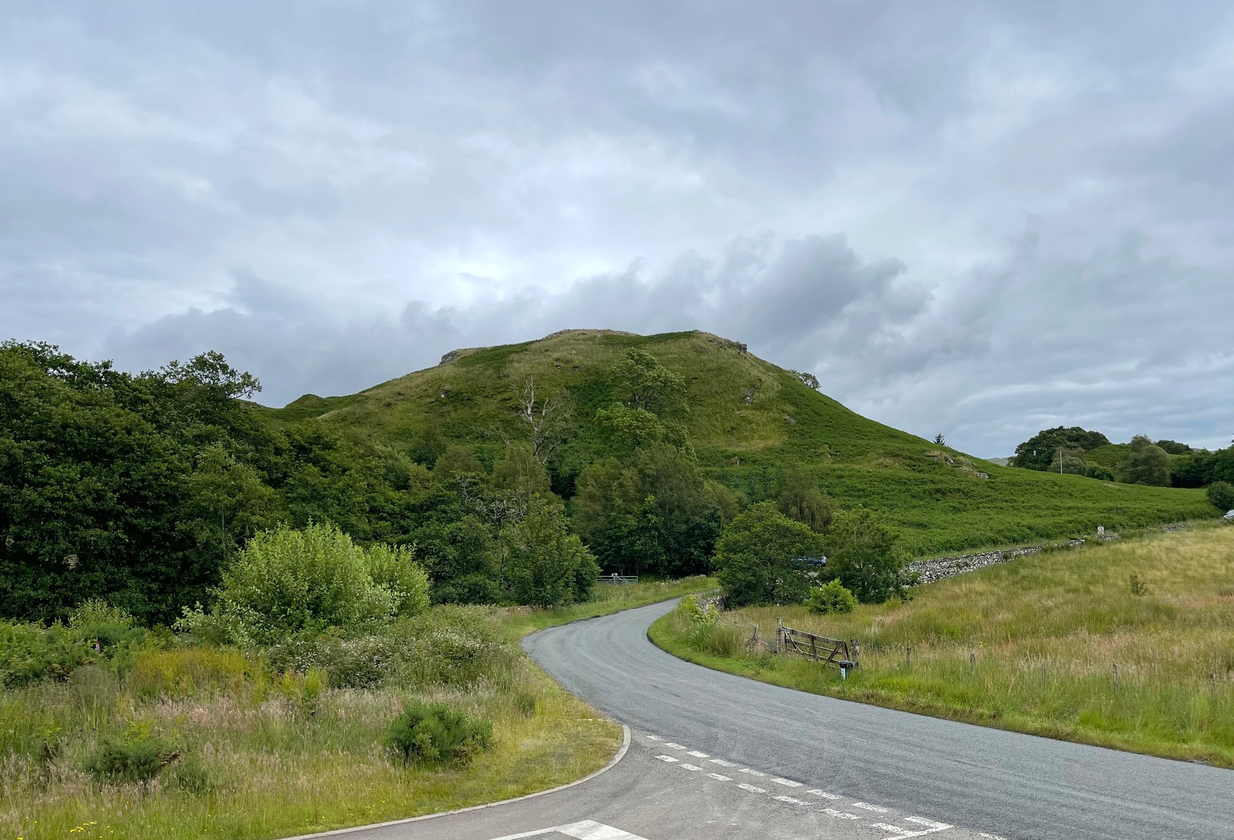
You can see the rocky hillock ‘pon which this old dun sits from the roadside – and can approach it by either climbing up the slope, or go round t’ back and approach it from t’ track. Either way, it’s easy to get to.
Archaeology & History
This old dun was rather ramshackled when I used to sit here, sometimes on my way home from working at the Inverliever Nursery, a bit further up the lochside — but it was a good spot to sit and daydream into Loch Awe and beyond…
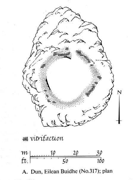
Described as a vitrified fort, the structure is oval in shape. Thought to have been constructed in the Iron Age, Dun Toiseach was originally about 50 feet across and its walls averaged 10 feet thick, with an entrance at its northeastern side. The Royal Commission lads (1988) described it thus:
Dun Toiseach plan (after RCAHMS 1988)
“Situated on a prominent rocky knoll overlooking the S end of Loch Awe 250m ESE of Torran farmsteading, there is a severely ruined dun measuring about 16m by 13m within a wall which has been some 4m thick. Two stretches of outer facing-stones are visible, as well as a few possible stones of the inner face, but, particularly on the NE, the wall has been severely robbed and the core material scattered. The entrance lies on the NE, the innermost portion of the SE passage-wall and what may be a door-jamb on the opposite side still being visible. The knoll has acted as a focus for recent field-walls, but there is no indication that it was additionally defended by outworks. A small modern cairn…surmounts the dun wall on the SE.”
References:
Royal Commission on the Ancient & Historical Monuments of Scotland, Argyll – Volume 6: Mid-Argyll and Cowal, HMSO: Edinburgh 1988.
Follow the directions to reach Churn Milk Joan, the head 100 yards east till reaching the crossing of footpaths, beneath Crow Hill. Take the northern (left) route and keep walking. Half a mile along you’ll see the tall upright stone to your left. You can’t really miss it!
Archaeology & History
The Greenwood Stone is an old boundary stone and is not prehistoric. It stands more than four feet tall. I first visited the site in 1988 in the company of several folklore and antiquarian writers, including Andy Roberts, Edna Whelan and Graeme Chappell. Twas a good day and coincided with a small collection of Psilocybes being gathered!
The tall upright is a boundary stone that was erected in 1775, as evidenced by the date carved on its southern face. I must emphasize however that this was not when the stone came to acquire its name: this was defined in 1594 as evidenced by a boundary perambulation written that year where it is described as being recumbent: “thence to one lying stone, newly named Greenwood Stone.” About 10-15 yards away is what may have been that very “lying stone,” the original Greenwood Stone, half-buried in the heather some six or seven feet long. It is possible this may have stood upright in the distant past.
Greenwood Stone, looking south
Moving about 75 yards south we come across another small standing stone at 1360 feet (412m) above sea level. This I’ve called the ‘Greenwood B stone’. It was marked on an old map as a boundary stone and is distinctly shaped to stand upright, marking a point separating the moors of Midgley and Wadsworth. When stood upright it is just visible on the horizon when looking from the Miller’s Grave prehistoric tomb several hundred yards east of here and is close to being an equinox indicator.
References:
Bennett, Paul, The Old Stones of Elmet, Capall Bann: Milverton 2001.
Take the B6478 road between Clitheroe and Newton, heading up north out of Clitheroe until you’re on the very top of the hill with fine views, mainly north and west. There’s a car-park about here, on the right-hand side of the road. From here, walk further along the road for about 200 yards, keeping your eyes peeled for the large stone trough at the left-hand side of the road. That’s it!
Archaeology & History
When we met up with John Dixon in the summer of this year, to wander on the nearby hills in search of old monuments, this was the first spot he showed us — and the waters were flowing nicely and tasted alright aswell! But its history is not widely know. Jessica Lofthouse (1976) described the place, saying:
“In the days of horse and pedestrian traffic none passed Walloper Well without stopping to ‘quaff the clear crystal.’ Long ago, hill men, hunters, forest wardens and farmers off to Clitheroe markets and fairs, pedlars, lead miners from the nearby workings, all met here. The name is thought-provoking. Why Walloper? From a word meaning a ‘fresh bubbling spring’, which this is, fresh from the moorside into stone troughs. Age, wartime army practice and vandalism of 1974 made renewal of the trough necessary, but the flow has been constant. One must drink, just as one throws pennies into the Roman fountain, to ensure one comes back again.
“The true derivation does not satisfy everyone. One can choose. A man and his wife climbed towards Walloper with raised voices, she nagging, he protesting. A pedlar watched them. “I’ll tell thee what I’d do if she were my wife. I’d wallop her, wallop her, wallop her well.” A song which every local singer was once compelled to have in his repertoire told the same story. The chorus sums up the reason for the name:
“…lovers of tell, each beau to his belle
The olden time story of Walloper Well.
The mason who built it in love with a maid
Who brought him his dinner one day, so tis said,
Was struggling to kiss her when over the Fell
A pedlar then passing cried, ‘Wallop her well’.”
References:
Byrne, Clifford H., Mineral Springs and Holy Wells of North-East Lancashire, unpublished manuscript, 1972.
Lofthouse, North Country Folklore, Robert Hale: London 1976.
Triangulation & cairn atop of Rye Loaf Hill on a truly foggy eve
Best way is to take the Settle to Kirkby Malham road: a tiny little thing running steep from Settle up and around the hills, making sure you don’t miss the turn-off to Kirkby and head down to Airton instead. About 100 yards along from the road-junction to Kirkby, there’s a small copse of trees and a gate just before it. Walk up through that and head right to the top of the nice hill a mile or so ahead of you to the north. It can be boggy, slippy and well good! A decent Barmy Bennett expedition this way lies! Get to the top of the hill and you can’t miss the cairn!
Archaeology & History
First shown on the 1771 Greenwood map, this is another intriguing little-known antiquity in our Yorkshire hills. It’s intriguing as the precise age and nature of the site doesn’t appear to have been ascertained. On top of this lovely rounded hill is not only a stunning view for many miles in all directions (unless you climb it on a very cloudy foggy day, like we did!), but the rock-pile which someone in recent years has turned into a wind-break has been taken from a much larger, and much older rock-pile on the very summit.
The cairn stands about a yard tall at the highest and measures roughly 12 yards in diameter, but the edges of the site seem to disappear further beneath the peat and vegetation on the hilltop. A section in the middle of the cairn has obviously been dug into, probably to create the stone shelter on its southern side, but it also gives the impression of having been dug into by treasure-seekers in the past — similar to the trenches found in the Snowden Crags cairn circle, the Great Skirtful of Stones and other prehistoric tombs.
The site has been marked on Ordnance Survey maps as a simple marker cairn (non-antiquated writing on the maps), but I have strong suspicions after visiting this peak that the cairn in question is a lot older than has previously been assumed. So I contacted local archaeologist Robert White and asked if he knew of any archaeological data about the cairn, but he said there was nothing that he knew. However, an additional piece of information that adds potential to the antiquity of the cairn came from the awesome pen of Harry Speight (1895) who told that,
“The original name of this eminence is Inglehow, which suggests like Ingleborough and ancient look-out post or beacon hill.”
The suffix how or howe is well-known to place-name students in northern England and beyond as a burial mound or tumulus. We must be cautious however, for as Gelling (1988) says, the word “is frequently applied to a tumulus, but it can refer to a natural hill.” But Speight’s idea that the name may have had something to do with beacons was mentioned — albeit without reference to Rye Loaf Hill, whose history and features he ignored — in Thomas Whitaker’s (1878) huge survey, where he wrote:
“In this parish was an immemorial custom, continued within the memory of many persons yet alive, of kindling fires on the tops of the surrounding hills on St. Laurence’s Eve, the 9th of August. This night was called the Kennel or Kennelk night; and the tradition of the place is, that the fires were intended as a memorial of the beacons kindled by the Saxons to alarm their countrymen on the sudden approach of the Danes.”
The parish in question that Whitaker described was Giggleswick, which is right next door to Settle, in whose parish Rye Loaf Hill lives.
On the southern edge of Rye Loaf are a couple of other archaeological place-names that need looking at. We have a couple of ‘Stone Haws’, which are probably cairns, close to which we find extensive evidence of human activity at some time in the past. But close to one of these piles of stones is another, far more fabled rock whose history appears to have long since been neglected: the Dragon Stone of Scosthrop Moor. Never heard of it? That’s not surprising…
References:
Gelling, Margaret, Signposts to the Past, Phillimore: Chichester 1988.
Smith, A.H., English Place-Name Elements – volume 1, Cambridge University Press 1956.
Speight, Harry, Tramps and Drives in the Craven Highlands, Elliot Stock: London 1895.
Whitaker, Thomas Dunham, The History and Antiquities of the Deanery of Craven in the County of York, (3rd edition) Joseph Dodgson: Leeds 1878.
Follow the same directions to reach the recently discovered Slade-02 carving; and simply walk 30 yards southwest. The scattered ruins of numerous small stone piles, visible only when the heather’s been burnt back, is what you need to be looking for.
Archaeology & History
First discovered on a Northern Antiquarian outing in July 2011, it’s difficult to give an accurate appraisal of this site as much of the landscape all round here is very overgrown in deep heather. Added to this, there is evidence of more recent medieval and post-medieval industrial activity that’s intruded and/or affected the earlier prehistoric remains that are evident here. But these factors aside, we can say with certainty that here is a previously unrecognized prehistoric cairnfield — and it may be of some considerable size.
Ruined hut or cairn circle
We have so far located at least seven individual cairns and a cairn circle in relative proximity to each other, thanks to local rangers burning back the heather. It was the discovery of the cairns which then led to the discovery of the nearby cup-and-ring stones. Amidst the cairn-spoils there are also distinctive lines of stone, indicative of either walling or embankments of some form or another. Some of the stone making up this cairnfield appears to have been robbed. We also found that in walking through the deeper heather surrounding this ‘opening’ (where it had been burned away a few months previously), a number of other man-made piles of stone were evident that seemed to indicate more cairns. There is also evidence of further lines of prehistoric walling, whose precise nature is as yet unknown. But we do know that people have been on this moorland since Mesolithic times (structural and other remains of which are still evident less than a half-mile away).
The site requires greater attention the next time the heather’s been burnt back.
References:
Davies, J., “A Mesolithic Site on Blubberhouses Moor, Wharfedale,” in Yorkshire Archaeological Journal, part 161 (volume 41), 1963.
Although originally classed as a stone circle, this site should more accurately be described as a form of cairn circle, as burial remains were found in the middle. This is noted by both Aubrey Burl (2000) and John Barnatt (1989), who thought it to be a kerbed cairn. It’s only a small circle aswell, about 5 yards across and is found not far from other burial cairns in the neighbourhood.
First discovered around Easter in 1965 by the then owners of the farm, Mr & Mrs K. Jarman, parts of the circle were dug into by their children, who subsequently informed Sheffield City Museum of their finds. Subsequently, the circle was then described in a short article by J. Radley (1969) in ‘Notes on Archaeological Finds’ for the Yorkshire archaeology group. He wrote:
“The circle is 15ft in diameter and is made of ten stones which protrude a few inches above the turf cover. Inside the circle the ground is slightly concave. A two-feet wide trench was dug across the circle and a large stone was revealed at the centre. On the stone was a fragmented urn, remains of a cremation, and one fragment of flint. There are signs of burning on the stone, and also under the stone, but no other burial has been discovered. The whole burial was so shallow that it was in the root zone of the overlying grass. The survival of many pieces of bone in such a wet location suggests that the area must have been protected by a mound until quite recent times…
“The urn is too fragmentary to be restored. Of the hundreds of fragments, only a few retain both faces, and these are generally one centimetre thick. The urn appears to have been made of a fine clay with large grits and has a smooth brown surface marked in places with impressions of blades of grass. The urn may have been biconical in form with bands of horizontal grooves around the upper part, with vertical grooves below them.”
References:
Barnatt, John, The Stone Circles of Britain – volume 2, British Archaeological Reports: Oxford 1989.
Burl, Aubrey, The Stone Circles of Britain, Ireland and Brittany, Yale University Press 2000.
Radley, J., “A Stone Circle on Kirkmoor Beck Farm, Fylingdales,” in Yorkshire Archaeological Journal, part 167, volume 42, 1969.
From Marsden itself, take the A62 road west and where the road bends round, the large hill rising on your left is where you’re heading. There’s a parking spot near the bottom of the highest part of the hill. From here, walk right to the top, up whichever route you feel comfortable with. At the very top is an intrusive modern monolith (dedicated to somebody-or-other, which the fella wouldn’t approve of if he really loved these hills*). About 10 yards east of the stone is a small grassy mound with a bittova dip in the middle. That’s it!
Archaeology & History
This is a little-known prehistoric site, whose remains sit upon a very well-known and impressive hill on the western edges of Marsden. Described in Roy Brook’s (1968) excellent survey on the history of Huddersfield as “the most important site” from the Bronze Age in this region, it seems curious that the attention given to it has been relatively sparse and scattered. The tops and edges of the hill have been cut into and worked upon by the uncaring spade of industrialism (of which there is much evidence), aswell as much of the peat being used for fuel over countless centuries — some of which appears to have been cut close to the all-but-lost remains of this once-important burial site.
The first description of the hill itself seems to be in 1426, where it was named in the Ramsden Documents, “past’ voc’ le Pole.” (Smith 1961) It wasn’t until appearing as Puil Hill on the 1771 Greenwood map that the title we know of it today began to take form. Local people would alternately call it both Pule and Pole Hill. But its name is somewhat curious, as the word appears to derive from the variant Celtic and old English words, peol, pul and pol,
“meaning a pool or marsh, especially one that was dry in the summer. Pole Moor therefore means Pool or Marsh Moor…and Pule Hill = the hill in the marsh.” (Dyson 1944)
Remains of mound looking NWSmall mound at left-centre
However, in Smith’s English Place-Name Elements, he gives an additional piece of word-lore which seems equally tenable, saying the word may be “possibly also ‘a creek'”, which could be applied to the water-courses immediately below the west side of the hill. We might never know for sure. But the archaeological remains on top of Pule Hill have a more certain history about them…
The burial site first appears to have been mentioned in a short article by Henry Fishwick (1897), who wrote:
“Whilst searching for…flints on the summit of Pule Hill a few weeks ago a discovery was made which is of considerable antiquarian interest. On the highest point of the hill, and from 12 to 18 inches below the surface, were found two human skeletons lying on their sides almost directly east and west, the knees of both being drawn up. Near to them were two small circular urns measuring 4¾ inches high, 5 inches across the top, and 6 inches in diameter at the widest part, the base being 3 inches across. These are made of native clay very slightly burnt, and are ornamented with short lines (apparently cut with some sharp instrument) which forms a rough herring-bone pattern. On the centre band are four ears or small handles which are pierced so as to admit a small cord. The urns contained animal matter and a few calcined human bones.
“Since the discovery of these two urns another has been exhumed from the same place. It measures 3½ inches in height and 7 inches in diameter at the widest part, which is just below the rim of the mouth. Its ornamentation is similar to the others, but quite so elaborately executed; the base is made with four feet or claws. On one side of the urn is an ear or handle pierced with a small hole in the direction of a double-groove, in which it is placed; there is a second double-groove near the bottom. When found this urn only contained sand. Fragments of a fourth urn were discovered on the same spot… The discoverers of these were Mr G. Marsden and Mr F. Fell.”
As a consequence of this, a couple of years later members of the Yorkshire Archaeology Society took it upon themselves to have a closer look at the place — and they weren’t to be disappointed. They cut a large trench across the top of the site from east to west, digging down until they hit the bedrock of the very hill; then dug an equal trench as much as 30 yards to the north, and on the southern side to the edge of the hill near where it drops. They came across,
“In three places were found distinct cavities…driven into the rock to a depth of about eighteen inches, the dimensions of which…averaged three feet long by two feet wide.”
Drawings of urns & bowls (Manby 1969)Mr Petch’s old photos of the bowls & urns
Within these rock cavities they found small portions of bone, charcoal and flint. It was also found that the urns which were described earlier by Mr Fishwick, had been found laid on their sides “at the places where the cavities were subsequently discovered.” Inside the urns, the remains of various human bones were discovered and reported on by Mr Boyd Dawkins: a craniologist of some repute in his time.
The discoveries were remarked upon a few years later — albeit briefly — in D.F.E. Sykes (1906) excellent history work of the area, where he told us that it was one of his esteemed friends, “George Marsden of Marsden…who was fortunate enough in August, 1896, to find” the ancient remains. But perhaps the most eloquent description of the Pule Hill remains was done by James Petch (1924) of the once-fine Tolson Museum archaeology bunch in Huddersfield (still open to the public and very helpful indeed). Mr Petch wrote:
“Several Bronze Age interments have been found in the locality. Of these the most important is that discovered on the summit of Pule Hill and excavated in 1896 by the late Mr. George Marsden. The finding of an arrowhead led to digging and four urns containing burnt human remains, and so-called “incense cup” were uncovered and removed (Figures 24, above, and 25, below) . In 1899 the site was again opened up for further examination. It was then noted that the urns had been set in cavities dug into the rock to a depth of about 18 inches. The type of the urn fixes the interment as belonging to the Bronze Age, and characteristic of such interments are the rock-cavities. The site is however somewhat exceptional in that no trace was found of the mound which was usually heaped over an interment. As the site is very exposed, the mound may have been weathered away, leaving no traces visible to-day. Along with the urns were found an arrowhead, one or two scrapers, a disc, a few pygmies and a number of flakes and chippings. It is important to note that these flints are mostly the relics of a Mas d’Azil Tardenois workshop which existed long before the interment was made on the summit of Pule Hill, and that they have no necessary connection with the Bronze Age burial…
“Owing to the generosity of the late Mr. George Marsden, the discoverer, and his family, the urns are now in the Museum. They form one of the most striking exhibits in the Prehistoric section. They are illustrated in Figures 24 and 25, above.
“The smallest of the group (Figure 24, 1 and 2, above) belongs to the type known as “incense-cups,” this name being the result of a somewhat fanciful attempt to account for the perforations the examples always show. It is quite evident and widely recognized now that this explanation – that they were in fact censers – is unsatisfactory, and that the use of this peculiar type of vessel is a problem as yet unsolved. Nos. 3 and 4 and Fig 25, 1 and 2 (above), are styled “food vessels,” such as may have been their ordinary use.
“No. 3 is ornamented with slight indentations, and without lugs; it has two strongly marked beads around the mouth, with a distinct groove between them. No. 4 has two slight lugs opposite to one another, which appear to have been pinched up from the body of the vessel; they were perforated but the holes have been broken out. Fig. 25, Nos 1 and 2 (above), is the best of the series, it is ornamented with small cone-shaped indentations and shows several unusual features; the width is great in proportion to the height; the lugs are not opposite and were attached to the vessel after it was made; the one on the left is seen to be perforated, and the position of the second is above the figure 2 in the illustration. The four feet were attached in a similar manner, and are not solid with the body of the vessel. All the vessels are hand made and show no indication of the potter’s wheel.”
Ceremonial bowl from the site (J. Petch 1924)
The site has subsequently been listed in a number of archaeology works, but there’s been no additional information of any worth added. Manby (1969) noted that of the four vessels from this prehistoric ‘cemetery’, one bowl was of a type more commonly found in East Yorkshire — though whether we should give importance to that single similarity, is questionable.
One thing of considerable note that seems to have been overlooked by the archaeological fraternity (perhaps not too surprising!) is the position of these burial deposits in the landscape. To those people who’ve visited this hill, the superb 360° view is instantly notable and would have been of considerable importance in the placement and nature of this site. The hill itself was probably sacred (in the animistic sense of things) and is ideal for shamanistic magickal practices. The communion this peak has with other impressive landscape forms nearby – such as the legendary West Nab — would also have been important.
For heathens and explorers amongst you, this is a truly impressive place indeed…
Barnes, Bernard, Man and the Changing Landscape, Eaton: Merseyside 1982.
Brook, Roy, The Story of Huddersfield, MacGibbon & Kee: London 1968.
Clark, E. Kitson, “Excavation at Pule Hill, near Marsden,” in Yorkshire Archaeological Journal, volume 16, 1902.
Cowling, Eric T., Rombald’s Way, William Walker: Otley 1946.
Dyson, Taylor, Place Names and Surnames – Their Origin and Meaning, with Speicla Reference to the West Riding of Yorkshire, Alfred Jubb: Huddersfield 1944.
Elgee, Frank & Harriet, The Archaeology of Yorkshire, Methuen: London 1933.
Faull, M.L. & Moorhouse, S.A. (eds.), West Yorkshire: An Archaeological Guide to AD 1500 – volume 1, WYMCC: Wakefield 1981.
Fishwick, Henry, “Sepulchral Urns on Pule Hill, Yorkshire,” in Proceedings of the Society of Antiquaries, volume 16, 1897.
Manby, T.G., “Bronze Age Pottery from Pule Hill, Marsden,” in Yorkshire Archaeological Journal, volume 42, part 167, 1969.
Petch, James A., Early Man in the District of Huddersfield, Tolson Memorial Museum: Huddersfield 1924.
Smith, A.H., The Place-Names of the West Riding of Yorkshire – volume 2, Cambridge University Press 1961.
Sykes, D.F.E., The History of the Colne Valley, F. Walker: Slaithwaite 1906.
Watson, Geoffrey G., Early Man in the Halifax District, HSS: Halifax 1952.
Acknowledgements: Huge thanks to Ben Blackshaw, for guiding us to this and other sites in the region!
* To be honest, I think it’s about time that these increasing pieces of modern detritus that keep appearing in our hills, dedicated to whoever, should be removed to more appropriate venues, off the hills, keeping our diminishing wilderness protected from them in ways that real lovers of the hills deem necessary. Such modern impositions are encroaching more and more and intruding upon the places where they simply don’t belong. I’ve come across many hill walkers who find them unnecessary and intrusive on the natural environment, so they should be discouraged. There is a small minority of sanctimonious individuals who seems to think it good to put their clutter onto the landscape, or want to turn our hills into parks – but these personal touches should be kept in parks, instead of adding personal touches where they’re not needed. Or even better, put such money into things like schools, hospitals or communal green energy devices. People would much prefer to be remembered by giving the grant-money to the well-being of others, instead of being stuck on a stone on a hill (and if not, well they definitely don’t belong to be remembered in the hills!). What if everyone wanted to do this?! Or is it only for the ‘special’ people. Please – keep such things off our hills!


")


