Stone Circle (destroyed): OS Grid Reference – SM 8615 1428
Archaeology & History
Described in context with an extant standing stone 100 yards to the north, this stone circle seems to have been destroyed in the latter half of the 19th century. It was described in the Royal Commission’s huge Pembrokeshire (1925) survey, after they had visited the site and viewed the remains. They told us:
“On the side of the road immediately opposite to Cliff Cottage, and constituting part of the garden walls of Upper Lodge, are numerous boulders which formed a well-defined stone circle. A few years ago they were moved, dressed, and used for walling. The entrance to the circle is said to have faced north-east. The southern portion was still visible about the year 1896.”
As far as I’m aware, local people report that a couple of the stones are still visible in the overgrown walling. Students working for the Welsh Coflein database allege that the remaining stones “are of doubtful antiquity.” Unless they have some substantial evidence to validate this statement (none is given) their remarks should be taken with a pinch of salt.
References:
Royal Commission Ancient & Historical Monuments, Wales, An Inventory of the Ancient Monuments in Wales & Monmouthshire: VII – County of Pembroke, HMSO: London 1925.
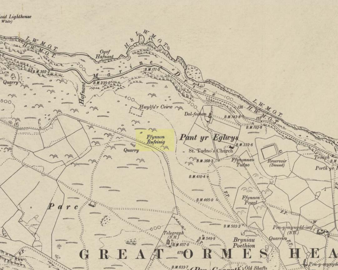
To be found on the legend-filled landscape known as the ‘Great Orme’, this ancient well was highlighted on the 1901 OS-map of the region, on the south side of the track. Sadly, despite an occasional puddle that fills the old trough when She rains, its waters are no longer running. H.C. Jones (n.d.) informed us that this was a ‘Roman Well’, which tradition said was a place they used when they invaded this part of Wales, although Paul Davies (2003) thought this “to be wishful thinking”.
Despite this, in recent years the walling around the well has been rebuilt by the track-side and a stone plaque with the words ‘Roman Well’ has been mounted to tell you that you’re at the right place.
References:
Davies, Paul, Sacred Springs, Blorenge: Llanfoist 2003.
Jones, H. Clayton, “Welsh Place-Names in Llandudno and District” in Mountain Skylines and Place-Names in Llandudno and District, Modern Etchings: Llandudno n.d. (c.1950)
This once important healing stone that was moved a short distance (from grid reference SN 1775 1875 to SN 1770 1874 according to officials) to its present spot, around 1925, whilst having a long history according to the folk traditions of Carmarthenshire, was previously questioned as an authentic site by none other than Prof John Rhys (1875), following his visit to the site in the 1870s. Although Rhys seemed an isolated voice, some modern archaeologists have also questioned its veracity. It’s difficult to say precisely what the original nature of the stone may have been, but it was certainly accommodated in medieval times as a healing stone and used in conjunction with a pagan well – which was of course, accommodated by the Church. If the stone itself had a megalithic pedigree, as some have believed, we know not what it may have been…
As Janet & Colin Bord (2006) wrote, the stone “still survives, but to the casual observer it looks like any other abandoned block of stone,” sitting innocuously within the ring of trees surrounding the church. An early account of the stone was written by E.L. Barnwell (1872), who told:
“The present church of Llangan in Carmarthenshire is a wretched structure, built in 1820, and is about to be removed, as the population has long since migrated to some distance from it, and in a few years even the memory of Canna’s church having once existed here may cease. There is, however, a relic still left, which we trust will not be overlooked by the local authorities, as indeed it seems to have been hitherto ; for no notice occurs of it in the account of the parish in Lewis’s Topographical Dictionary or any other work. This relic is a rude stone, forming a kind of chair, lying in a field adjoining the churchyard, and about thirty or forty yards from it. When it was removed to its present position is unknown. There was also a well below the church called Ffynnon Canna; and there is still a small brook available, if required, for following the rules prescribed to those who wish to avail themselves of the curative powers of the saint’s chair. It appears that the principal maladies which are thus supposed to be cured are ague and intestinal complaints. The prescribed practice was as follows. The patient first threw some pins into the well, a common practice in many other parts of Wales, where wells are still thought to be invested with certain powers. Then he drank a fixed quantity of the water, and sometimes bathed in the well, for the bath was not always resorted to. The third step was to sit down in the chair for a certain length of time; and if the patient could manage to sleep under these circumstances, the curative effects of the operation were considerably increased. This process was continued for some days, even for a fortnight or longer. A man aged seventy-eight, still living near the spot, remembers the well and hundreds of pins in it, as well as patients undergoing the treatment; but, about thirty or thirty- five years ago, the tenant carried off the soil between the well and the watercourse, so as to make the spring level with the well, which soon after partly disappeared, and from that time the medical reputation of the saint and her chair has gradually faded away, and will, in the course of a generation or two, be altogether forgotten.”
Folklore
In Wirt Sykes (1880) classic text, he told us that the field where the original Canna’s Chair may have been, possessed fairy-lore that we find at other sites, usually ascribed as prehistoric. He wrote:
“In the middle of this parish there is a field called Parc y Fonwent, or the churchyard field, where, according to local tradition, the church was to have been originally built; but the stones brought to the spot during the day were at night removed by invisible hands to the site of the present church. Watchers in the dark heard the goblins engaged in this work and pronouncing in clear and correct Welsh these words, “Llangan, dyma’r fan,” which means, “Llangan, here is the spot.””
References:
Allen, J. Romilly, The Monumental History of the Early British Church, SPCK: London 1889.
Baring-Gould, S. & Fisher, John, Lives of the British Saints – volume 2, London 1907.
Cup-Marked Stone (lost): OS Grid Reference – ST 260 870
Archaeology & History
Rhiwderin cup-marks
This fine-looking cup-marked stone was uncovered during a botanical outing in the last decade of the 19th century. Described as being around the township of Rhiwderin, the exact whereabouts of the carving is unknown and it’s not been seen since the first description of it in an early edition of Archaeologia Cambrensis by Mr T.H. Thomas. (1895) John Sharkey (2004) mentioned the site in his recent survey of Welsh rock art, saying simply “location unknown.”
The missing Rhiwderin stone
Although we know there are no hard and fast rules for working out the location of cup-and-ring markings, one may be fortuitous in exploring any nearby Bronze Age or neolithic tombs (cairns, tumuli, etc) in the Rhiwderin district, as they do tend to enjoy the company of such sites — but I must stress, this is by no means a dead cert!
Mr Thomas’s description of the carving was as follows:
“I enclose a sketch of what seems to be a cup-marked stone which I observed yesterday near Rhiwderin, Monmouth. Unless there be some operation which simulates such markings with which I am unacquainted, I take the specimen to add an instance of these mysterious prehistoric remains to the very short list given for Wales by Mr. Romilly Allen, and to be the first reported for South Wales.
“The stone displaying the cup-markings is a mass of millstone grit, earth-fast, the slanting surface appearing above the turf being about a yard wide, and 4 feet long. Upon the upper half of the surface is a group of twelve cups from 1½ to 2in diameter, and about 1in deep. On first noticing the cups they were taken for holes out of which quartz pebbles, abundant in the local millstone grit, had been weathered, but examination of the block showed that no pebbles of large size exist, or had existed in it, and the conclusion was arrived at that the cups are artificial.
“On turning back some of the turf covering the base of the slope of the stone, no other cups were discovered.
“The stone lies within an old enclosure, as shown by wild apple-trees and an abundance of daffodils, and still more clearly by ruins, which seem those of a cottage or small farm near by. This contiguity to a habitation which does not seem to have been abandoned more than a century, made me suspect some medieval or more recent origin for the markings. I cannot, however, account for them otherwise than by supposing them to be cup-markings in the technical archaeological sense.
“The stone was observed while in the company of Dr C.T. Vachell of Cardiff, searching for varieties of narcissus which occur at several points in the neighbourhood…”
If anyone comes across this lost carving, please let us know!
References:
Sharkey, John, The Meeting of the Tracks: Rock Art in Ancient Wales, Gwasg Carreg Gwalch: Llanrwst 2004.
Thomas, T.H., ‘Archaeological Notes and Queries,’ in Archaeologia Cambrensis, volume 12 (5th series), 1895.
From the Denbigh road (A543 and A544) turn off at Llansannan for Gwytherin on the B5384 for 6 miles or so. At the village of Gwytherin St Winifred’s church stands roughly in the middle of the place at a junction of four roads. The church stands upon a small round hill and within the confines of the churchyard (north side) are four small standing stones – you can’t really miss them!
Archaeology & History
At the northern side of the churchyard near the wall there’s an alignment of four small standing stones probably dating from the Bronze Age. The stones stand roughly 3 metres or 6 feet apart and are about 1 metre or 3 feet in height. The westernmost stone has a Latin inscription carved onto it which is ‘VINNEMAGLI FILI SENEMAGLI’, or, ‘The Stone of Vinnemaglus, son of Senemaglus’, which is generally thought to date from the Romano-British period in the 5th-6th century AD and to be a grave marker. Most probably the inscription was carved onto the prehistoric stone during the early Christian period — the stones themselves being from pre-Christian times.
The general thinking is that these stones belonged to a Bronze Age settlement that stood here long before any church was founded. Perhaps there were other stones here forming a linear alignment that must have meant something to the ancient folks who lived here. There has also been speculation as to whether the inscribed standing stone could actually mark the grave of St Winifred herself.
The churchyard is circular, indicating that it is a pagan sacred site. Celtic churches being built on sites like this to Christianize them, but not entirely forget the meaning to the peoples of “the old religion,” as it’s called. Also in the churchyard stand three ancient yew trees — yet another sign that the site is a holy one.
The first church in Gwytherin was founded by St Eleri (Elerius), a Welsh prince, in the mid-7th century. He may be identical with St Hilary, a saint commemorated at a village of that name near Cowbridge, South Glamorgan. Other than that, Eleri and his mother, Theonia, founded a double monastery here: one for men and the other for women, to which a young St Winifred (of Holywell) came to and was elected second abbess after Theonia. St Eleri was probably a disciple of St Beuno, uncle to St Winifred, and also her cousin. Here in 650 or 670 AD Winifred was buried in the churchyard — her relics being taken to Shrewsbury abbey in 1138.
References:
Burl, Aubrey, From Carnac to Callanish, Yale University Press 1993.
Houlder, Christopher, Wales: An Archaeological Guide, Faber & Faber: London 1978.
Hulse, T.G., Gwytherin: A Welsh Cult Site Of The Mid-Twelth Century, (unpublished paper) 1994.
Nash-Williams, V.E., The Early Christian Monuments of Wales, Cardiff, 1950.
Westwood, J.O., “Early Inscribed Stones of Wales,” in Archaeologia Cambrensis, 18:255-259, 1863.
From the Chester ring road head into north Wales along the coast road (A548) from Connah’s Quay for about 13 miles taking you through Flint. After 12 miles turn left into Holywell town (Treffynnon). At the western end of the town go down the Greenfield-Mostyn road back towards the A584 taking you down a hill. After 500 hundred yards you arrive at the holy well/shrine and pilgrimage centre on the right-hand side; there is parking on the opposite side of the road. There is a small entrance fee, but as well as the famous healing well and bathing pool, they have a gift shop, toilet facilities and a late medieval/Gothic two-storey structure that is built over the polygonal, vaulted well chamber, whilst at the side (at the corner of the hill) stands another Gothic chapel from 1500.
History and Legend
According to the well known legend, a young Welsh girl called Winefride or Gwenfrewi, was the daughter of patrician parents, Thenith (Thewyth) and Gwenlo, who lived at Bryn-y-Castell (Treffynnon) at the beginning of the 7th century AD. She was a very religious girl who was known for her kindness and charities to people in the area that was then called Tegeingl (after the Decengle tribe). Winefride grew up to be a very beautiful young woman which troubled her because she had no wish to marry, only to live a life of chastity and serve God as only she knew how.
St. Winefrides Well 1742
One day a local chieftain from Hawarden (Penarlag) called Caradoc ap Alyn came hunting in the area. He became very thirsty so stopped off at the house where Winefride lived with her parents. However, on this particular day her parents were attending the local church where St Beuno, her uncle, was conducting a service. Prince Caradoc soon began to seduce her so she ran to the church but with the prince in hot pursuit. When he caught up with poor Winefride, she again resisted him so he took his sword and beheaded her. Her severed head fell to the ground and rolled down a hill and where it came to rest a spring of water gushed forth from the ground. Her parents and uncle came rushing out of the church at which point St Beuno cursed the evil prince, who was calmly wiping blood from his sword, causing him to sink into the ground — never to be seen again. St. Beuno then placed the severed head back into place, restoring Winifred to life again but leaving her with a thin scar round her neck.
Later, Winifred was entrusted for her education to St Beuno whom sent her to various holy men including St. Elerius at Gwytherin near Llanwrst. Here she became abbess of a convent that had been founded by Elerius, with his mother St. Theonia as first abbess; and it was here for the next 40 years that Winifred lived out her life. She was said to have died at Gwytherin in either 65o or 670 AD. Her body was first interred in the churchyard there, however in 1138 her relics were transferred to Shrewsbury Abbey. Sadly however, her shrine there was destroyed in the 16th century and now only a few relics remain with a finger-bone being housed at a convent in Holywell.
Mythology and Folklore
St. Winefrides Well 1750
The holy well and shrine of St. Winifred at Holywell became a place of pilgrimage during the middle-ages and many miracles of healing were wrought there. The sick were cured of infirmities of the legs and body; crutches were left at the well and many were cured of leprosy, eye complaints, loss of hearing, being not able to bear a child, mental illness, palsy and lung disorders etc. During the Reformation the holy well suffered much, but from the 17th century onwards pilgrims were returning to the holy place and, more recently it has become the Welsh Lourdes and still pilgrims come in droves from all over Wales and beyond. The vaulted Gothic structure covering the well shrine is richly carved with bosses depicting various characters including St Beuno, Earl Stanley, Lady Margaret Beaufort, biblical characters, animals and an abbot of Basingwerk abbey, but there is also much recent graffiti too. A tall statue of St Winefride looks down over the well while candles burn all around. In the larger bathing pool outside, a stone lies at one side — this is claimed to be where St. Beuno sat whilst teaching his young niece. Red stains on stones at the front of the well-basin were long taken to be the martyr’s bloodstains, but now these are thought to be iron oxide pigmentation on the lichens. Today the people still come either to bathe in the special pool, throw coins in the well, or fill bottles with holy water from a tap on the wall. Faith in miracles of healing is still much in evidence here and may it continue to be for many years to come. Everyone is welcome here, you don’t have to be a Roman Catholic!
References:
Bord, Janet & Colin, Sacred Waters, Paladin: London 1986.
David, Christopher, Saint Winefride’s Well – A History and Guide, Gomer Press: Llandysul 2002.
Edwards-Charles, Thomas, Saint Winefride and Her Well – The Historical Background, Holywell 1962.
Heath, Sidney, In the Steps of the Pilgrims, Rich & Cowan: London 1950.
Jones, Francis, The Holy Wells of Wales, University of Wales Press: Cardiff 1992.
From Llangollen, take the A542 north for about three miles up along the famous Vale of Llangollen. At the ruined abbey of Valley Crucis continue along the same road for another ½-mile whence, at the side of the road in a field and upon a small mound, stands the ancient monument: the Pillar of Eliseg.
Archaeology & History
The sandstone pillar or pillar-shaft stands upon a large square-shaped base stone which sits atop a tumulus — a Bronze Age burial mound (cairn) inside which were found, during excavations in 1803, the remains of a body, perhaps that of a Romano-British or Dark-Ages chieftain (possibly Eliseg?), with what were described as “blue stones” both beneath and on top; the cremated body lying within a stone-slab chamber along with a silver coin. But the ancient pillar monument itself is much later in date — probably mid-9th century AD, though there has been speculation by some historians that the pillar was actually a tall cross, alas without its head, dating from a couple of centuries earlier, with the inscription being carved onto it sometime between 840-845 AD. It was erected by Prince Cyngen fab Cadell (Concenn) about the year 844 in memory of his great-grandfather Eliseg or Elise. Cyngen died in Rome in 854 AD.
Over the centuries the pillar has suffered from the ravages of time. Its long Latin inscription was originally 31 lines divided into readable paragraphs running horizontally but now only 7 or 8 of these lines are visible. But fortunately the writer and historian Edward Lhuyd made a drawing of the monument and its inscription back in 1696. The inscription when translated reads as follows:
1. Concenn son of Cadell, Cadell son of Brochmail, Brochmail son of Eliseg, Eliseg son of Guoillauc
2. Concenn therefore being great-grandfather of Eliseg erected this stone to his great-grandfather Eliseg
3. It is Eliseg who annexed the inheritance of Powys…throughout nine (years) from the power of the English which he made into a sword-land by fire
4. Whosoever shall read this hand-inscribed inscription stone, let him give a blessing on the soul of Eliseg
5. It is Concenn Who…with his hand…to his own kingdom of Powys…and which…the mountain…the monarchy Maximus…of Britain…Concenn, Pascent…Maun, Annan.
6. Britu, moreover, (was) the son of Guorthigirn (Vortigern) Whom (St) Germanus blessed and whom Severa bore to him, the daughter of Maximus the king who slew the king of the Romans and
7. Convarch painted this writing at the command of his king Concenn
8. The blessing of the Lord (be) upon Concenn and all members of his family and upon all the land of Powys Until the day of judgement or doom. Amen.
The upper section of the pillar, which is broken at the top, was re-erected on top of the burial mound in 1779 which probably means that the monument is not in its original place. The lower section was sadly broken away from the shaft during the English Civil war and has long since disappeared. However, this monument is still quite an impressive site and can be seen from a great distance around.
References:
Bartrum, P.C., Early Welsh Genealogical Tracts, Cardiff: UWP, 1966.
Barber, Chris, More Mysterious Wales, Paladin 1987.
Houlder, Christopher, Wales: An Archaeological Guide – the prehistoric, Roman and early medieval field monuments, Faber and Faber, London 1974.
Tyack, George S., The Cross in Ritual, Architecture and Art, William Andrews: London 1900.
Westwood, J.O., Lapidarium Walliæ – The Early Incised and Sculptured Stones of Wales, Oxford University Press 1879.
From Tregele village, take the minor southeast road towards Llanfechell, until you pass the second dirt-track on your right (both tracks take you to a local farm). The second track takes you to the aptly-named farmhouse of ‘Cromlech’ – which is where you need to ask the farmer (a friendly chap) if you can have a gander at his rocks! To which he should say, “Aye…it’s over there in the field.” You can’t really miss ’em!
Archaeology & History
This was once an impressive prehistoric tomb by the size of things, but has been knocked about a bit over the centuries. Even when Glyn Daniel (1950) described it, he said that “at present this site consists of nothing more than a number of large stones lying in a field — some flat and others slightly tilted.” And it hasn’t changed much since then! One of the earliest descriptions of Foel Fawr was by John Skinner (1908) in his fine tour around Anglesey in the early 19th century, where he told:
Skinner’s 1804 drawingFoel Fawr tomb
“From hence passing by an old mansion named Cromlech now tenanted by a farmer we came to the spot where many large stones were lying scattered promiscuously on the ground and one nearly square measuring nine feet across leaning against some uprights about six feet high. From the appearance of this place I should rather imagine that it had been the interior or cistfaen of a carnedd and this opinion seems somewhat confirmed by the accounts of the common people who remember great quantities of stone having been removed to form a wall.”
References:
Daniel, Glyn E., The Prehistoric Chamber Tombs of England and Wales, Cambridge University Press 1950.
Skinner, John, Ten Days’ Tour through the Isle of Anglesey, December 1802, Charles J. Clark: London 1908.
Go north on the A5026 from the town of Holywell for about 3 miles; at the hamlet of Lloc take the turning first right towards Trelogan village for another mile – the ancient cross stands in the corner of a field at the junction of 3 roads at the turning from Whitford to Trelogan, halfway between Whitford and Sarn. The cross can also be reached via Pantasaph from the A55.
History
The cross probably dates from 1000 AD and is said to be the tallest wheel-headed cross in Wales, standing at 11 feet 3′ in height. The metal fence surrounding the cross spoils the monument quite a bit, but it is there for security reasons. It is richly decorated on all sides and on the cross-head. Much of the decoration is Celtic in origin, but there are also Viking influences here, probably Northumbrian. On the south face there is a human figure standing on a serpent that has associations with the Norse god Odin; also a three-legged horse that may also be connected to Odin. The north-west face has Celtic pattern-work in the form of the letter “X” and below that another figure (naked) holding a spear. The north-east face is rather eroded, but there is some Celtic-style decoration. There is more knotwork and chainwork elsewhere on the cross with other animal figures. The wheel-head has a distinctive central boss and a four star-shaped cross radiating from the boss.
Folklore and Legend
The cross is also called ‘The Stone of Lamentation’ because penances were carried out at the cross in the Middle Ages. This act would have concluded with weeping and the ‘act of contrition’ by pilgrims visiting the site whilst making their way between St Winifred’s Well and St David’s. Legend says that St Cwyfan, a local 7th century Celtic saint preached on this site and set-up the cross – hence the name, Maen Achwyfan. One local legend tells us that Queen Boudica fought her last battle against the Romans close by in the fields called ‘Cydio ar Leni’ or ‘The fields of the seizing legions’. During the Middle Ages the monks of Basingwerk Abbey preached at the cross and also set up a chapel for pilgrims just to the south at Whitford.
References:
Allen, J. Romilly, “Celtic Crosses of Wales”, in Archaeologia Cambrensis, 1899.
Owen, Rev. Elias, Old Stone Crosses of the Vale of Clwyd and Neighbouring Parishes, Bernard Quaritch: London & Oswestry 1886.
Sharkey, John, Celtic High Crosses of Wales, Carreg Gwalch: Llanrwst 1998.
Westwood, J.O., Lapidarium Walliæ – The Early Incised and Sculptured Stones of Wales, Oxford University Press 1879.
Cup-Marked Stone: OS Grid Reference – SO 1576 5858
Also Known as:
Llanerch Stone
NPRN – 306082
Archaeology & History
Llanerch cup-marked stone (after Watkins, 1932)
A small and simple cup-marked boulder, hidden away in the Welsh hills, all-but unknown even to cup-and-ring fanatics! It’s nowt special to look at, reminding me somewhat of the numerous cup-marked rocks that scatter the edges of Baildon Hill in Yorkshire. Found close to a number of other prehistoric sites, the stone isn’t in its original position so we’re unable to tell whether it was associated with any tombs (as is probable). The carving consists of around 32 cup-marks, with some 18 of them visible on its upper face. It’s likely that there were more cups on it originally, for when it was first found (as shown in the photo here, taken soon after being discovered) one side of the stone had been split away, but the other section was nowhere to be seen. Alfred Watkins (1932) told how it was first discovered:
“Following a visit by the Woolhope Club in 1928 to that fine mound on Radnor Forest—Cruger Castle…a fellow member (Mr. Walter Pritchard), working on alignments, discovered a fine cup-marked stone, at Llanerch Farm, a little south of the mound. I visited and photographed the stone the same year, and took a rubbing of the cup-marks on it, also taking as careful a bearing as possible, and marking it on the paper while on the stone.”
Its isolation is a little unusual, but there are likely to be other carvings scattering the nearby hills and valleys awaiting discovery by enthusiastic explorers.
Folklore
The great ley-hunter himself, Alfred Watkins (1932) — following in the footsteps of some of his contemporaries it’s gotta be said — used this carving to add fuel to his notion of leys and aligned sites, thinking that the cup-markings on the stone were representative of such things, etched thousands of years back to be used by other travellers. Can’t see it misself — but then I did spend a few years looking at the potential relevance cup-and-rings had with alignment features when I was a boy, ruining many a-map and finding they had no relationship whatsoever to such things! But it seems that Mr Watkins was still going through the exploratory phase at the time, because, after taking a rubbing of the stone he told:
“I also (as soon as I got home) tested for alignments, and inked in those of four cups which I found, as I considered lines of three to be of no value as proof. I could not at that time see any tangible proof of anything, and put it down to this (broken) stone having probably been moved. The reproduction I give is of this crude rubbing exactly as I finished it (outlining then the rather indefinite edges of the cups) in 1928.”
References:
Sharkey, John, The Meeting of the Tracks: Rock Art in Ancient Wales, Gwasg Carreg Gwalch: Llanrwst 2004.
Watkins, Alfred, Archaic Tracks round Cambridge, Simpkin Marshall: London 1932.


")
")