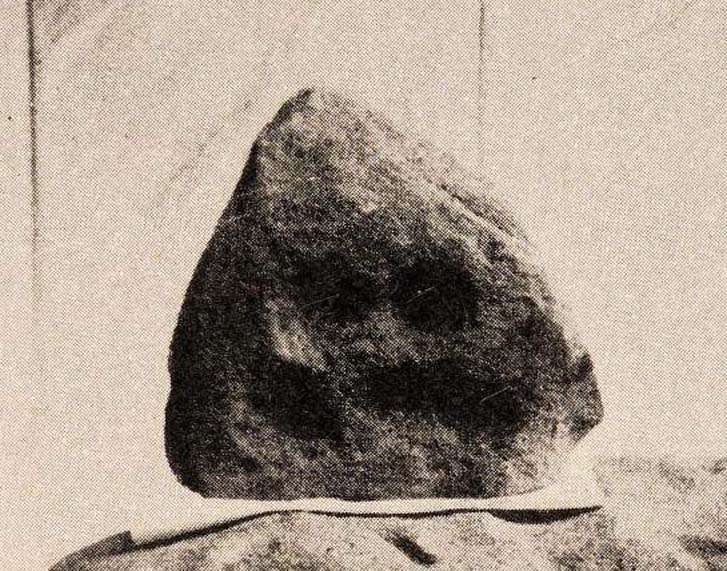
Inside the once prominent prehistoric tomb on the Cow Keeper’s Field, the northern antiquarians William Hornsby and John Laverick (1920) came across two small petroglyphs in association with a cremation burial, several feet south of the central cist: the Cow Keeper’s Field 2 carving, plus this small, triangular-shaped stone, 8in by 6in, consisting of five standard cup-marks, with two of the cups (as the photo shows) connected to each other. It is akin to the numerous ‘portable’ cup-marked stones which, in other cultures, were deposited onto cairns in remembrance of the ancestral spirits of the tomb. Such widespread practices may also have occurred here. Petroglyph researcher and writer Graeme Chappell (2017) informed us that the carving “is in storage in the Dorman museum in Middlesborough.”
References:
Brown, Paul & Chappell, Graeme, Prehistoric Rock Art in the North York Moors, Tempus: Stroud 2005.
Chappell, Graeme, Personal communication, October 4, 2017.
Crawford, G.M., Bronze Age Burial Mounds in Cleveland, Cleveland County Council 1990.
Elgee, Frank, Early Man in North-East Yorkshire, John Bellows: Gloucester 1930.
Hornsby, William & Laverick, John D., “British Barrows round Boulby,” in Yorkshire Archaeological Journal, volume 25, 1920.
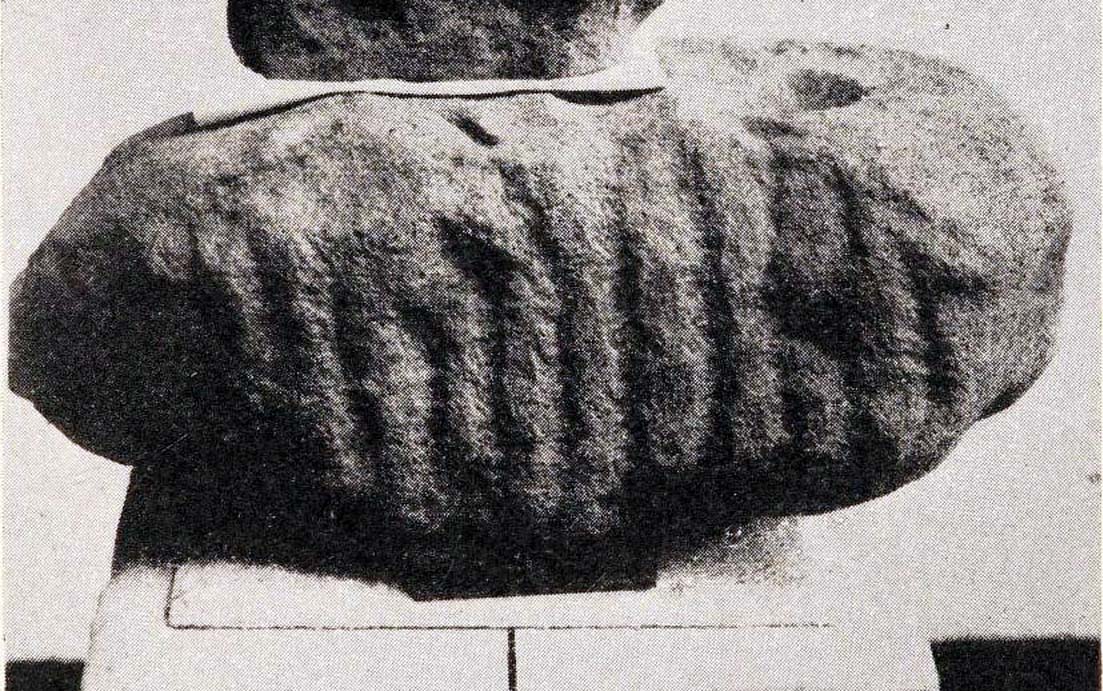
Inside the once prominent prehistoric tumulus on the Cow Keeper’s Field (now destroyed), the northern antiquarians William Hornsby and John Laverick (1920) came across two small portable petroglyphs: the Cow Keeper’s Field 1 carving, plus this “peculiarly marked stone” as they put it, some “5ft south of the centre” where a cist, or stone-lined burial existed. Measuring 18in by 7in, the rock carving consists of at least one large cup-marking which is clearly evident on top of the stone, plus what seems to be another one next to it, half-covered. Along the side of the stone, a series of twelve roughly parallel lines have been carved out, running down to the bottom of the stone. Rock art researcher and writer Graeme Chappell (2017) tells us the carving is supposed to be “in storage in the Dorman museum in Middlesborough,” although no one has seen it in years. It would be worthwhile if fellow research students could visit the said museum to recover this and other portable cup-marked stones that were found in the area.
References:
Brown, Paul & Chappell, Graeme, Prehistoric Rock Art in the North York Moors, Tempus: Stroud 2005.
Chappell, Graeme, Personal communication, October 4, 2017.
Crawford, G.M., Bronze Age Burial Mounds in Cleveland, Cleveland County Council 1990.
Elgee, Frank, Early Man in North-East Yorkshire, John Bellows: Gloucester 1930.
Hornsby, William & Laverick, John D., “British Barrows round Boulby,” in Yorkshire Archaeological Journal, volume 25, 1920.
This prehistoric tomb was one in a cluster of tumuli in the Boulby district, uncovered by the northern antiquarians, William Hornsby and John Laverick in 1918. Most of them have subsequently been destroyed – this one included. When they visited the site, they described it as “a barrow…with a diameter of 36 feet.” Once they began digging into it,
“at the centre we found a cist, the top of which was 2ft 7in below the present surface. The cist lay north 64° west, and south 64° east. It had no cover and the slab at the north-west end was wanting. The cist measured: side 3ft 6in, end 3ft 2in. Its depth was 2ft 2in. In it we found nothing except sandstone chips. With these there was no admixture of soil. Above the cist and covering a space of 5 ft by 5 ft there was a layer of burnt earth and black ashes (of furze bushes). At a distance of 5 ft south of the centre, and 1ft 10in below the present surface, there was a burnt burial, 20in in diameter. With this we found many flint chips, a shale pendant, and the peculiarly marked stone” we’ve called, simply the Cow Keeper’s Field 2 carving.
A second cup-marked stone was also found inside the tomb, a few feet south of the cist. When G.M. Crawford went to survey the burial mound in the late 1970s, he reported “there is no trace of it” and “has probably been destroyed by ploughing.”
References:
Brown, Paul & Chappell, Graeme, Prehistoric Rock Art in the North York Moors, Tempus: Stroud 2005.
Crawford, G.M., Bronze Age Burial Mounds in Cleveland, Cleveland County Council 1990.
Elgee, Frank, Early Man in North-East Yorkshire, John Bellows: Gloucester 1930.
Hornsby, William & Laverick, John D., “British Barrows round Boulby,” in Yorkshire Archaeological Journal, volume 25, 1920.
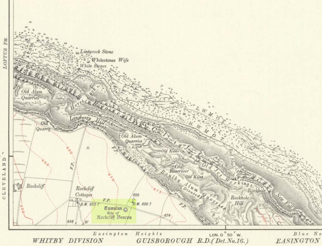
Occupying a prominent position above the ever-closer North Sea, upon which an old beacon was subsequently placed, this denuded prehistoric tomb was first surveyed by the Ordnance Survey lads in 1913, and subsequently in an essay by Messers Hornsby & Laverick (1920) on the ancient sites of Boulby, east of Easington. This was the first one they explored, calling it ‘Mound No.1.” They located it,
“due south of the ‘Soldier’s Garth’ in the east corner of the field called The Falls. It was a cairn with a diameter of 50ft. Two-and-a-half feet northwest of the centre peg, at a depth of 21 inches below the present surface, there was an unaccompanied burnt burial, which occupied a space of 15in by 18in. In a centre cut 7ft 6in by 6ft, at a depth of 3ft 6in, we found much burnt bone and many potsherds of the Bronze Age type, scattered over the whole space of the trench, down to a further depth of 3ft 10½in. In the south corner there were four stones set on edge and running in a direct (straight) line. The interment had been placed upon the clay, the soil of the original surface having been cleaned off. With this burial we found a good flint made from a polished celt and worn smooth at the point—possibly through having been used for striking fire on iron pyrites—many chips and several cupstones.”
The “several” cup-marked stones they describe at the end seem to have been lost; perhaps sleeping in some museum cellar somewhere (does anyone know?).
This cairn was one in a complex of eight that Frank Elgee (1930) suggested may have been laid out deliberately in the form of the constellation of Ursa Major, or The Plough, also known as ‘Charles Wain’.
References:
Brown, Paul & Chappell, Graeme, Prehistoric Rock Art in the North York Moors, Tempus: Stroud 2005.
Crawford, G.M., Bronze Age Burial Mounds in Cleveland, Cleveland County Council 1990.
Elgee, Frank, Early Man in North-East Yorkshire, John Bellows: Gloucester 1930.
Hornsby, William & Laverick, John D., “British Barrows round Boulby,” in Yorkshire Archaeological Journal, volume 25, 1920.
Tumulus (destroyed): OS Grid Reference – TA 4160 1748
Archaeology & History
In and around East Yorkshire, the fabled Yorkshire antiquarians William Greenwell and J.R. Mortimer uncovered and excavated many now-lost prehistoric tombs—some of which, beneath the rounded tumulus of earth, were constructed out of wood instead of stone. A little-known site, now long gone, once existed in what is now the North Sea, just a few hundred yards off the Easington coast. Other sites close by are soon to be completely swallowed back into Earth’s body, right on the water-line, but the site described here has long gone. What little was known of it was described in Mortimer’s (1905) magnum opus, where he told:
“On the beach at Easington, in Holderness, under a tide-demolished barrow, Dr Hewetson and the writer on April 21st, 1894, discovered a double cist made of broad slabs split from the outer shell of the decayed trunk of a willow tree. This barrow had been swept away by the waves, and its site was at about half-tide-line, and a considerable way from the very low cliffs. Lining the grave with wood (the branches of trees) would not be difficult to accomplish and would be practised as a protection to the body.”
A henge monument and several other prehistoric barrows have been located in and around Easington, but they’re fading fast!
References:
Mortimer, J.R., Forty Years Researches in British and Saxon Burial Mounds of East Yorkshire, A. Brown: London n.d. (1905).
Take the B6478 road between Clitheroe and Newton, heading up north out of Clitheroe until you’re on the very top of the hill with fine views, mainly north and west. There’s a car-park about here, on the right-hand side of the road. From here, walk further along the road for about 200 yards, keeping your eyes peeled for the large stone trough at the left-hand side of the road. That’s it!
Archaeology & History
When we met up with John Dixon in the summer of this year, to wander on the nearby hills in search of old monuments, this was the first spot he showed us — and the waters were flowing nicely and tasted alright aswell! But its history is not widely know. Jessica Lofthouse (1976) described the place, saying:
“In the days of horse and pedestrian traffic none passed Walloper Well without stopping to ‘quaff the clear crystal.’ Long ago, hill men, hunters, forest wardens and farmers off to Clitheroe markets and fairs, pedlars, lead miners from the nearby workings, all met here. The name is thought-provoking. Why Walloper? From a word meaning a ‘fresh bubbling spring’, which this is, fresh from the moorside into stone troughs. Age, wartime army practice and vandalism of 1974 made renewal of the trough necessary, but the flow has been constant. One must drink, just as one throws pennies into the Roman fountain, to ensure one comes back again.
“The true derivation does not satisfy everyone. One can choose. A man and his wife climbed towards Walloper with raised voices, she nagging, he protesting. A pedlar watched them. “I’ll tell thee what I’d do if she were my wife. I’d wallop her, wallop her, wallop her well.” A song which every local singer was once compelled to have in his repertoire told the same story. The chorus sums up the reason for the name:
“…lovers of tell, each beau to his belle
The olden time story of Walloper Well.
The mason who built it in love with a maid
Who brought him his dinner one day, so tis said,
Was struggling to kiss her when over the Fell
A pedlar then passing cried, ‘Wallop her well’.”
References:
Byrne, Clifford H., Mineral Springs and Holy Wells of North-East Lancashire, unpublished manuscript, 1972.
Lofthouse, North Country Folklore, Robert Hale: London 1976.
Very little can be seen of this once large oval-shaped prehistoric enclosure, a mile south of Slaidburn, on the level below the rise towards Easington Fell. Few archaeologists know about the site and there has been little written about it. Although very little of it is visible at ground level today, three-quarters of the site is vaguely discernible from the air and on GoogleEarth, as the photo here shows. The Skelshaw Ring was described in Greenwood & Bolton’s Bolland Forest (1955), where they said, “The late Colonel Parker (Browsholme Hall) claimed to have found a good specimen of an ancient earthwork above Easington Green. Unfortunately, this has been ploughed over during the last war (WWII).” And little else appears to have been said of the place until the Lancastrian writer John Dixon (2003) wrote about it. More recently John said the following about the site:
Skelshaw Ring plan (after Dixon 2003)
“This oval earthwork, 320 ft. diameter, crowns a small hill on the general slope of the east bank of Easington Beck. It consists of a ditch and bank with a gateway through the bank and a causeway across the ditch on the west side. Inside the bank and ditch the ground rises gently into a rounded hill so that most of the inside of the earthwork is well above the level of the bank.
“During the spring of 1934 a preliminary excavation of the site was undertaken by the late Dr. Arthur Raistrick. Three sections were cut through the ditch and bank and the inner area was briefly explored.
“Although nothing was obtained to date the earthwork, the sections did show the ordered structure of the site and proved the presence of large floors that may well have been the site of huts.
“This site may be compared with the large ringwork at Fair Oak Farm, SD 648 458, as both have a similar size and the same features are displayed. Bleasdale Circle, SD 577 460, is a slightly smaller ringwork, but I consider all three monument (plus: Easington Fell Circle [no:2] SD 717 492 ) to have the same origins.
“These earthworks represent the first settlements of a people determined to tame, settle and cultivate the landscape. What we observe at Skelshaw is the possible farmstead of an extended family unit, part of a clan that worked the land here some 4000 years ago in what is referred to as the Bronze Technology Period.”
Go through the gorgeous old village of Waddington northwards, uphill, along the B6478 road, towards the villages of Newton and Slaidburn; or, if you like, go from Newton village uphill southwards along the B6478 road towards Waddington. Either way, when you reach the top of the moors, park up at the car-park beside the road where the view stretches for miles ahead of you. Walk on the road for 100 yards, then take the boggy footpath left, going first down and over a stream, then up to the right (northeast) towards a small cairn on the near-horizon. From the cairn-top you’ll notice a large moorland pond a hundred or so yards ahead of you. Walk towards and past its left side and onwards again for the same distance until, in front of you (before a nearly-dried stream running downhill) keep your eyes peeled in the deep grasses on where you’ll see a very large ring raised in front of you, defined in parts by scatterings of rocks along the tops and sides. You’re here!
Archaeology & History
This is an outstanding prehistoric site, all but lost in old literary records until relocated in recent years by Lancashire historian and writer, John Dixon. However, its precise nature remains a bit of a puzzle. When John took a small party of us to the site on June 16, 2011, there was a variety of ideas as to the precise nature of the place.
Southwestern arc of the Ring
Structurally similar to a number of prehistoric enclosures in the Pennine range, this very large near-circular monument consists primarily of a very large number of rocks and stones making up a thick outer wall, presently piled less than a yard high above the peat and approximately 6 feet wide on average. From north-to-south, outer wall to outer wall, it measures more than 42 yards (38.5m) across; whilst measuring 41 yards (38m) east-to-west. There are distinct entrances on its western and northern sides, and possibly another on the east. Certain sections of the inner region are now somewhat boggy in parts, perhaps indicating there was at one time an internal spring of water. A large singular stone is found on the inner eastern section, which may have been placed there deliberately. On the northwestern inner-edge of the walling is a notable long wide stone which may have stood upright.
My first impression of the site told it to bet at least Iron Age in date, though more probably Bronze Age. But without excavations, I could be talking bullshit! It is an obvious enclosure of some sort, but there are no visible internal structures on the present ground level. There are no notable internal or external ditches and banks, which may have given the site a ‘henge’ classification. More work is obviously needed here before we can say what it is for sure.
Very little has been said of this huge ring in the past. John Dixon’s research found the site briefly described in Greenwood & Bolton’s (1955) work, saying:
“On page 24 they refer to the above site thus: ‘There is also a rough stone circle on top of the fells above Easington, like the remains of an ancient fort (the ringwork)…'”
Also mentioning how Richard Rauthmell’s Antiquitates (1746) very briefly mentions the place aswell. Apart from these passing remarks, John has found little else.
On other parts of this moortop we found scattered evidences of other early human remains (walling, cairns, hut circles), much of it unrecorded. There may well be other important prehistoric remains hidden upon these hills…
An intriguing and little-known carved stone whose existence has been brought to our attention by historian and author John Dixon. Its precise history and nature seems unknown; but aspects of the carving possess symbols that are found on early christian remains, as well as some cup-and-ring designs. John wrote:
Artist’s impressionFoulscales Stone
“This enigmatic stone (27 inches height, 12 inches wide, 6 inch thickness), anciently known as the Yolstone and later as the Bonstone, once stood behind Foulscales Farm, near Gibbs. For some reason the stone was removed from this site and taken into the cellars of Knowlmere Manor under the authority of the Peel Estate.
The stone displays possible early native chi-rho symbols that may have a 6/7th century provenance. The lettering ‘HT’ look to be of 16/17th century origin and may refer to the Towneley family who held lands in Bowland.”
Was it a boundary stone? A gravestone? Was it an early christian stone? A Romano-British stone? The carved circles with ‘crosses’ inside them are typical Romano-British period designs, covered extensively in the early works of J. Romilly Allen and found to be widespread across Britain. Any further information on this stone would be greatly appreciated.