It’s probably easiest to start from the Green Plain settlement, from here crossing the Sun Bank Gill stream and walking east through the scattered heather and grasslands for 450 yards to the right-angled edge of the woodland. Keep walking eastwards alongside the woods for about another 250 yards, then walk into the grasslands north for about 140 yards or so. Zigzag about – you’re damn close!
Archaeology & History
Only for the purists amongst you. This is a simple small triangular stone, with a single notable cup-mark near the middle. It would seem to be in isolation as we could find no others in the immediate vicinity. An early marker no doubt.
Acknowledgements: With thanks to Helen Summerton, who helped with location on this fine day.
From Blubberhouses church by the crossroads, walk up the slope (south) as if you’re going to Askwith, for 100 yards or so, taking the track and footpath past the Manor House and onto the moor. Once you hit the moorland proper, take the footpath that bears left going down into heather and keep going till you hit the dead straight Roman Road path running west onto Blubberhouses Moor. Carry along the Roman Road for about 200 yards as though you are going towards the Eagle Stone, and looking right (if you squint) you can just make out a small pimple on the top of the moors about a quarter of a mile away. That is where you are heading (be warned – it is boggy getting there).
Archaeology and History
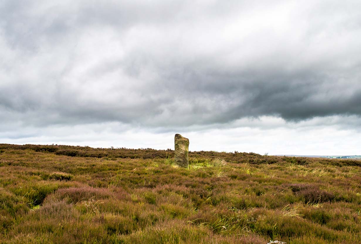
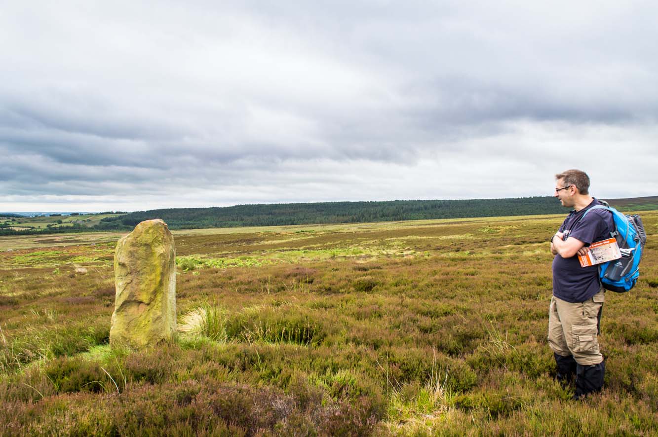
James Stone, looking NE
Discovered (or rather ‘noticed’) by James Turner and James Elkington in July 2016 (hence the name James Stone), this standing stone is of an indeterminable age – although it does look ancient. Standing more than 5 feet tall, and in the middle of nowhere, it is fairly difficult to get to unless you want to get wet feet. It is situated very close to a small and unexcavated prehistoric settlement and we could find no physical evidence of any tracks nearby (although Google Earth does show what looks like one or two very short, faint tracks near the stone, which is the old ‘Benty Gate’ track).
It could be a boundary stone, although doubtful – it has a feel to it that says it is prehistoric, although this is just guesswork on our part. I can find no reference to it in Cowlings Rombalds Way (1946) and there seems nothing about it in either of William Grainge’s (1871; 1895) detailed history works of the region.
Mr Turner gazing at the stone
At first we thought it unlikely to be a new find, however the stone is difficult to see from the Roman Road (I had been up here dozens of times before I noticed it) and seeing that people rarely go up here anyway, and it is relatively difficult terrain getting to it, it is not surprising that no one has bothered visiting it. It would take someone who is quite keen on megaliths to want to examine it and it is well off any tracks.
Having said that, it is a nice find and it could be linked in some way with the small unexcavated settlement nearby, or possibly the large Green Plain settlement nearly a mile away. Well worth a visit…bring your wellies!
References:
Cowling, Eric T., Rombald’s Way, William Walker: Otley 1946.
Grainge, William, The History and Topography of Harrogate and the Forest of Knaresborough, John Russell Smith: London 1871.
Grainge, William, The History and Topography of the Townships of Little Timble, Great Timble and the Hamlet of Snowden, William Walker: Otley 1895.
ON the A59 Harrogate to Skipton road, right on top where it crosses the barren moors, get to the parking spot right near where the road levels out at the highest point. Walk up the footpath from here onto the moors (south) for about 200 yards till you notice a small black pool ahead of you. From here, walk left (east) offpath and into the heather, roughly along the ridge for about another 150-200 yards. Zigzag about and keep looking. You’re damn close!
Archaeology & History
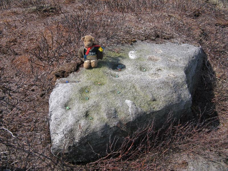
Close-up of some of the cups
Not far from the Gill Head stone and walling, another previously unrecorded cup-marked rock was discovered on the afternoon of Saturday, May 3, 2014, by Danny Tiernan and his famous teddy bear! The stone seems to have been previously well-covered, but was made visible thanks to the annual heather-burning on this part of the moor. He came across it during an exploratory Northern Antiquarian wander to examine a cluster of other neolithic remains hidden on this moor. The carving consists of a series of plain cup-markings, between eight and twelve in number, running along the middle of the rock and outwards nearer to the edges. The cups are between 1-2 inches across and a half-inch deep at the most. The design was first highlighted on Danny’s walking blog, Teddy Tour Teas — and is gonna be difficult to find once the heather’s grown back.
ON the A59 Harrogate to Skipton road, right on top where it crosses the barren moors, get to the parking spot right near where the road levels out at the highest point (2-300 yards past the turning to the derelict Dovestones Quarry). From here, go thru the gate onto the moor for about 100 yard. Then turn straight east (left) for another few hundred yards till y’ reach the spot marked as Gill Head Peat Moor on the OS-map. This small standing stone (right) is where you need to start – the other remains continue east of here.
Archaeology & History
Richard’s original photo, with walling clearly visible
The discovery of this site began in April 2005, when rock art student Richard Stroud and I were exploring the moors here and he called our attention to what seemed like a singular upright standing stone, some 3 feet high, with a debatable cup-marking on top, standing amidst a scatter of smaller stones running north and south from here, implying that the stone may have been a part of some much denuded walling from our ancient past. But we weren’t sure—and simply noted its location (at SE 13378 54924) and carried on our way. But in revisiting this site after looking at some old archaeology papers, Paul Hornby and I chanced to find a lot more on the burnt heathland running east of here.
The upright stone found by Mr Stroud is certainly part of some ancient walling, but it is much denuded and falls back into the peat after only a short distance. A short distance west of this stone is a small cairn which seems of more recent origin; but due east, along the flat plain on the moorland itself, the burnt heathland showed a scattering of extensive human remains, comprising mainly of walling, hut circles and possible cairns—lots of it!
One issue we have to contend with on this moorland is the evidence of considerable peat-cutting in places, which was being done on a large scale into the Victorian period. Scatterings of medieval work are also found across this moor, in places directly interfering with little-known Bronze Age monuments in the middle of the remote uplands. There is no doubt that some of these medieval and later workings have destroyed some of the uncatalogued prehistoric archaeological remains on this moor. But thankfully, on the ridge running west to east along Gill Head to above the source of the Black Dike, scattered remains of human habitation and activity are still in evidence. The only problem with what we’ve found, is the date…
Two rows of straight walling, with stone scatter all roundAnother overgrown curve of walling
In 1960, Mr J. Davies first mentioned finding good evidence of flint-workings at a site close by; then described his discoveries in greater detail in the Yorkshire Archaeological Journal (1963) a few years later — but contended that the remains were of mesolithic origin. A few years earlier, Mr D. Walker described a similar mesolithic “microlith site” a bit further north at Stump Cross. Earlier still, Eric Cowling (1946) and others had made similar finds on these and adjacent moors. Yet all of them missed this scatter of habitation sites, perched near the edge of the ridge running east-west atop of the ridge above the A59 road. It’s quite extensive and, from the state of the walled remains, seems very early, probably neolithic in origin.
A number of small hut circles, 2-3 yards across, are scattered amidst the heather, with lines of walling—some straight, some not—broken here and there by people who came to gather their peat for fuel. The walling and hut circle remains are very low to the ground, having themselves been robbed for stone it would seem. The area initially appeared to be little more than a mass of stones scattered across the Earth (and much of it is), but amidst this are very clear lines of walls and circles, although they proved difficult to photograph because of the excessive growth of Calluna vulgaris.
Curious man-made structure in dried peat-bog
A couple of hundred yards south there are remains of one of the many dried black peat-bogs—with one large section that has been tampered with by humans at some point in the ancient past. Over one section of it there has been built a small stone path, or possible fish-trap; plus elsewhere is a most curious rectangular walled structure (right) obviously made by people a long time ago. Also amidst this dried peat-bog are the truly ancient remains of prehistoric tree-roots emerging from the Earth, a few thousand years old at least – and perhaps the last remnants of the ancient forests that once covered these moors.
How far back in time do all these walled remains take us? Iron Age? Bronze Age? Or much much further…? Excavations anyone!?
References:
Cowling, Eric T., Rombald’s Way, William Walker: Otley 1946.
Davies, J., “A Mesolithic Workshop in Upper Wharfedale,” in Bradford’s Cartwright Hall Archaeology Group Bulletin, 5:1, 1960.
Davies, J., “A Mesolithic Site on Blubberhouses Moor, Wharfedale,” in Yorkshire Archaeological Journal, part 161 (volume 41), 1963.
Walker, D., “A Site at Stump Cross, near Grassington, Yorkshire, and the Age of the Pennine Microlith Industry,” in Proceedings of the Prehistoric Society, volume 22, 1956.
Follow the same directions to reach the recently discovered Slade-02 carving; and simply walk 30 yards southwest. The scattered ruins of numerous small stone piles, visible only when the heather’s been burnt back, is what you need to be looking for.
Archaeology & History
First discovered on a Northern Antiquarian outing in July 2011, it’s difficult to give an accurate appraisal of this site as much of the landscape all round here is very overgrown in deep heather. Added to this, there is evidence of more recent medieval and post-medieval industrial activity that’s intruded and/or affected the earlier prehistoric remains that are evident here. But these factors aside, we can say with certainty that here is a previously unrecognized prehistoric cairnfield — and it may be of some considerable size.
Ruined hut or cairn circle
We have so far located at least seven individual cairns and a cairn circle in relative proximity to each other, thanks to local rangers burning back the heather. It was the discovery of the cairns which then led to the discovery of the nearby cup-and-ring stones. Amidst the cairn-spoils there are also distinctive lines of stone, indicative of either walling or embankments of some form or another. Some of the stone making up this cairnfield appears to have been robbed. We also found that in walking through the deeper heather surrounding this ‘opening’ (where it had been burned away a few months previously), a number of other man-made piles of stone were evident that seemed to indicate more cairns. There is also evidence of further lines of prehistoric walling, whose precise nature is as yet unknown. But we do know that people have been on this moorland since Mesolithic times (structural and other remains of which are still evident less than a half-mile away).
The site requires greater attention the next time the heather’s been burnt back.
References:
Davies, J., “A Mesolithic Site on Blubberhouses Moor, Wharfedale,” in Yorkshire Archaeological Journal, part 161 (volume 41), 1963.
Cowling’s 1946 ground-plan of a portion of the settlement
From Blubberhouses church by the crossroads, walk up the slope (south) as if you’re going to Askwith, for 100 yards or so, taking the track and footpath past the Manor House and onto the moor. Once you hit the moorland proper, take the footpath that bears left going down into heather and keep going till you hit the dead straight Roman Road path running west onto Blubberhouses Moor. Go on here for nearly a mile until you hit the valley stream with its Eagle Stone down on your left. Walk downstream, past the Eagle Stone, and cross over 100 yards down until you’re back on the level ground with the scatter of bracken and heather. You’re here!
Archaeology & History
On the other side of the stream a short distance southeast of the large cup-marked Eagle Stone is a curious site, first described by Eric Cowling (1946) as “a series of enclosures of varying size and roughly circular shape” which he ascribed as a Bronze Age settlement. Certainly we have a rather extensive scattered group of walled structures just as he described, but not all of the walling here seems typical of local Bronze Age constructions. Cowling suggested the remains to be “useful for protection, herding and for shelter,” though admitted archaeological excavation would be the best way to ascertain their specific nature. Such undertakings have yet to be done — and I wouldn’t hold your breath either.
Large section of wallingWalls of large circular structure
Although he described some of the walls here as nearly four-feet tall, when Graeme Chappell and I first ventured here in the winter of 1990, the walling wasn’t quite as high. There are a number of individual tall stones sat in the walls that stand three-feet tall, with some that have been cut and dressed in more historic times. Who did this and when is unknown. However, if we visited this place when all the vegetation has been cut and burnt back at the end of winter and early months of Spring — a fact not lost on Cowling when he first found this place — we would gain a much clearer picture of things here.
Some sections of lower walling above the streamside appear to be prehistoric in nature, but many other parts of the walled structures across this flatland plain have a much later look and feel about them, illustrating that the site may have been used well into post-medieval periods. This seems increasingly obvious where we find a number of the stones cut at sharp angles, with some having distinctive quarried grooves in them. However, I can find no historical records to verify this at present.
Hut circle remainsMedieval cut upright stone?
If we walk up the slight slope westwards however (before bracken and heath grow) there are more distinct prehistoric remains in the form of typical hut circles with low walls emerging from deep peatlands — although even these have been cut in one or two places by metal tools. My view of this little-known but large settlement arena is that we’re looking at a site initially built in the Bronze Age period, continuing to be used by local tribespeople throughout the Iron Age and, as the cut stones clearly show, was a village that was certainly made use of in the last millenium. But until someone comes along here and gives the site the attention it deserves, we’re not gonna know…
On the southern fringe of the copious walled structures we also find a very curious medicinal chalybeate spring that may have been of some importance to those who once lived hereby. A ‘standing stone’ and prehistoric cairn can also be seen close by.
References:
Cowling, E.T., Rombald’s Way: A Prehistory of Mid-Wharfedale, William Walker: Otley 1946.
Same directions as the Slade 01 carving. But once you reach the upstanding stone cairn on the rocky hill, walk 220 yards (less than 200m) WSW and look around. You’re damn close! If you find the large cup-marked Slade 03 carving, walk back east about 10-20 yards and you can’t really miss it!
Archaeology & History
This is just one of at least seven previously undiscovered carvings on this section of moorland – and it’s worth looking for! The two other names we gave it — ‘owl’ and ‘sunset’ — come from the very notable design: owl thanks to it having the appearance of large owl-like eyes, and sunset as the two cup-and-rings are etched on the western edge of the rock and, when we found it yesterday, the sun was setting (albeit to the NW) and the image prompted talks of setting suns, the land of the Dead and other such worldwide indigenous religious myths (Harvey 2000) — for without recourse to such ingredients, these carvings are vacuous archaeocentric museum pieces and nothing more. And this carving at least deserves much more than mere cataloguing! The internationally renowned archaeologist, O.G.S. Crawford (1957) would have entered this carving into his ‘eye’ and ‘owl’ motif, representative of goddesses or spirit-forms, as would Gimbutas. (1989)
…and from above
But this carving is archetypal, as we can see, though would appear to have no other etched features on the stone’s surface. It is very close (if not within) the prehistoric graveyard that is plainly evident 30-40 yards south in the burnt heather and would very likely have had some mythic relationship with the dead (a symbiosis we have found in many cup-and-rings). We plan further ventures here in the coming weeks in the hope that we can unearth other prehistoric remains.
References:
Crawford, O.G.S., The Eye Goddess, Phoenix House: London 1957.
Gimbutas, Marija, The Language of the Goddess, Harper Collins: New York 1989.
Harvey, Graham (ed.), Indigenous Religions, Cassell: London 2000.
From Blubberhouses church by the crossroads, walk up the slope (south) as if you’re going to Askwith, for 100 yards or so, taking the track and footpath past the Manor House and onto the moor. Once you hit the moorland proper, take the footpath that bears left going down into heather and keep going till you hit the dead straight Roman Road path running west onto Blubberhouses Moor. Go on here for nearly a mile until you hit the stream and nearby Eagle Stone boulder. Walk upstream from here, on its eastern (right-hand) side for 100 yards, then walk up onto the level moor, scattered with rushes. Keep up here, heading towards the upright cairn open the skyline to the north. Once here, walk 80 yards (73m) WNW and you’ll note a number of flat stones embedded in the heather around you. You’re damn close!
Archaeology & History
Off-path and takes some finding and will all-but disappear when the heather grows back, so this one’s probably only for the purists amongst you. But I like it anyway! This is one of at least seven newly-discovered cup-marked stones hereby, including the nearby ‘Owl Stone’ with it’s big eyes! There are just two cup-marks on the flat surface: one an archetypal large cup 3 inches across and a half-inch deep; the other, a small faint cup less than 2 inches wide and very shallow which is easily missed if you pay little attention. On the photo here, the fainter cup is slightly above right of the centre. The carving appears to be on the far eastern edges of the Slade Cairnfield. Other undiscovered remains are likely to be found here.
To get here, follow the same directions as you would to reach the curious Green Plain settlement; but just before you reach that, you’ll notice this rather large boulder known as the Eagle Stone right in front of you next to the ever-decreasing stream. Wander down and give it a fondle — you can’t really miss it!
Archaeology & History
Cupmarks on top (image by Graeme Chappell)
Curiously not included in Boughey & Vickerman’s rock-art survey (2003), this large boulder stands just below the ancient ford which crosses Sun Bank Gill and is pitted with a number of cup-marks on its top (though not the 38 we counted when Graeme Chappell and I in the early 1990s), plus a large “bowl”, not unlike the Wart Well on top of Almscliffe Crags and other such sites. Although some of the cups seem natural, others are artificial — as even an English Heritage rock art student could tell you! A small cluster of ‘cups’ are on top of the stone, but a number of them have been etched onto the sloping southern face; a curved line running across the rock-face towards these cups may be natural.
The straight track above you was known as Watling Street in bygone years and was the old Roman road running between Ilkley and Aldborough.


")


