Charles Pooley (1868) gave a somewhat vague description of this site, telling that, “there is authority for believing that at one time a Cross was set up in the village.” I can find no other reference to this monument which, I presume, has been destroyed. (the grid reference cited is an approximation near the centre of the village, where village crosses were usually located)
References:
Pooley, Charles, Notes on the Old Crosses of Gloucestershire, Longmans Green: London 1868.
In R.C. Skyring Walker’s (1928) fine survey of Gloucestershire’s holy wells, he lamented the passing of this site, telling how
“it is sad to relate that this well has totally disappeared and its precise site is unknown.”
Since those words, the situation regarding its whereabouts has not been resolved. First mentioned in Samuel Rudder’s (1779) work, the main clue we’ve got regarding its whereabouts is his description of the adjoining hamlets and village tithes:
“Westonton, formerly called Old Marshfield, or Little Marshfield. It has been a distinct parish, called St Pancras, according to Sir Robert Atkins, and a well in this hamlet still bears the name of that saint.”
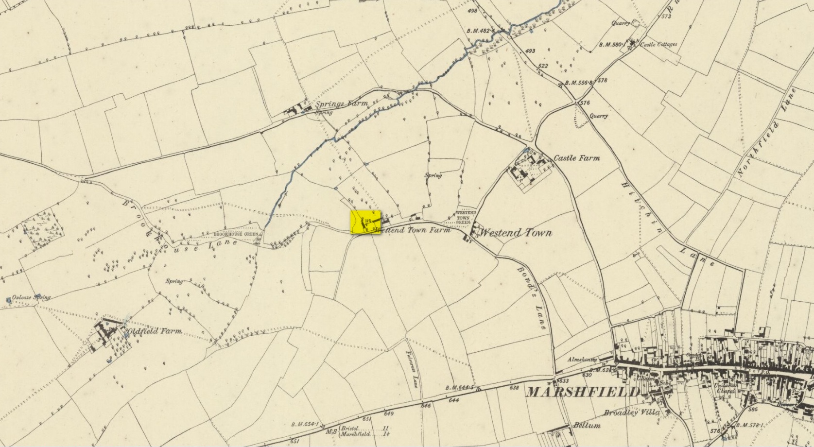
‘Well’ on 1886 OS-map
Westonton is the old farmhouse of Westend Town less than a mile northwest of Marshfield where, on early Ordnance Survey maps, a Well is shown. To the north of this is Springs Farm. This latter name probably has no bearing on St Pancras’ Well; but the location cited by Rudder of the well being in Westend Town gives us a damn good indicator as to where local historians should dig for this forgotten sacred site.
The Well was described in T.D. Fosbroke’s (1807) work, but only in passing. St Pancras’s festival date is April 3. (the grid reference cited for this well is an approximation)
References:
Fosbroke, Thomas D., Abstracts of Records and Manuscripts Respecting the County of Gloucester – volume 2, J. Harris: Cirencester 1807.
Rudder, Samuel, A New History of Gloucestershire, S. Rudder: Cirencester 1779.
Smith, A.H., The Place-Names of Gloucestershire – volume 3, Cambridge University Press 1964.
Walters, R.C. S., The Ancient Wells, Springs and Holy Wells of Gloucestershire, St Stephens Press: Bristol 1928.
Healing Well (destroyed): OS Grid Reference – SU 215 995
Archaeology & History
Not listed in the field-name surveys of the town, the name Slaughter Well was obviously a folk-name given to it by local people. The place was mentioned in an unpublished manuscript that Adin Williams’ (1888) managed to lay his hands on, where it was mentioned in relation to the missing pyramidal Market Cross. Its waters were “said to be medicinal.” The name of the well was said to derive from a battle here between Oliver Cromwell’s men and the Royalists. At this place,
“an officer was shot, and this incident gave the name ‘Slaughter’ to the well.”
References:
Williams, Adin, Lechlade: Being the History of the Town, Manor and Estates, The Priory and the Church, E.W. Savory: Cirencester 1888.
Cross (destroyed): OS Grid Reference – SO 9674 1321
Archaeology & History
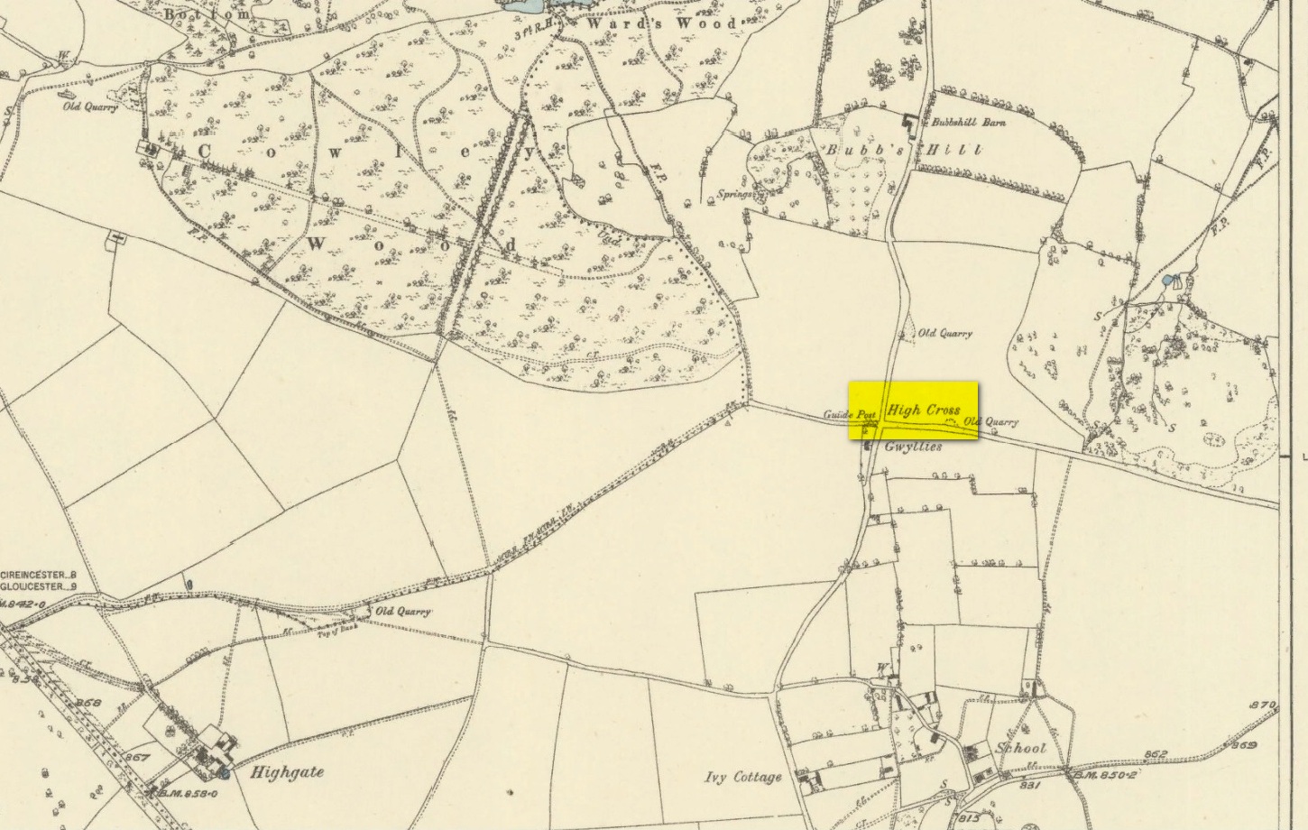
High Cross on 1883 map
First shown on a 1775 map of the region, this long-lost site is preserved in several place-names near the old crossroads a half-mile north of Elkstone village. It is mentioned, albeit briefly in Charles Pooley (1868) county survey, where he told that, “in former times a very handsome and lofty High Cross stood in this parish.” However, there’s the possibility that the name ‘High’ cross may here derive simply from a cross located at a high point in the landscape.
An old ‘Guide Post’ marked on the early Ordnance Survey map at the same spot has been suggested by Danny Sullivan—and not without good reason—to be a prehistoric standing stone. He may be right.
References:
Pooley, Charles, Notes on the Old Crosses of Gloucestershire, Longmans Green: London 1868.
Sullivan, D.P., Old Stones of the Cotswolds and the Forest of Dean, Reardon: Cheltenham 1999.
In days of olde, Charles Pooley (1868) told us that “an old cross formerly stood in the Market-place” in the centre of the town where the old crossroads meet—as was customary for crosses and maypoles—just outside the church of St. Lawrence. Pyramidal in form, it was mentioned in an old manuscript cited by Adin Williams (1888), which told us,
“Leland saith that in his days there was a Piramid of Stone at ye west end of ye Church, whose foundations are to be seen near Slaughter’s Well, which is said to be medicinal water.”
And although we don’t know when the cross was erected, we know when it was destroyed. Williams again tells us:
“About 1770, Sir Jacob Wheate pulled down this cross. He is said to have taken the stones to the house he was building.”
References:
Pooley, Charles, Notes on the Old Crosses of Gloucestershire, Longmans Green: London 1868.
Williams, Adin, Lechlade: Being the History of the Town, Manor and Estates, The Priory and the Church, E.W. Savory: Cirencester 1888.
In Charles Pooley’s (1868) definitive account of Gloucestershire county crosses, he informs us that,
“there was formerly a Cross erected in this village, but it has long since disappeared.”
He gives no further information about its history, but we must surmise that it was either associated with the ancient priory on the north side of the village, or in the traditional place at the centre of the the village. The grid-reference cited places the lost cross in the grounds of the priory.
References:
Pooley, Charles, Notes on the Old Crosses of Gloucestershire, Longmans Green: London 1868.
In Charles Pooley’s (1868) definitive history on the county crosses, this monument is mentioned in passing without any known history, apart form it been destroyed sometime in the early 19th century:
“A cross formerly stood in the churchyard, but it has been removed within living memory.”
References:
Pooley, Charles, Notes on the Old Crosses of Gloucestershire, Longmans Green: London 1868.
Healing Well (destroyed): OS Grid Reference – SP 166 350
Archaeology & History
This is one of several iron-bearing wells (chalybeates) that used exist in and around the village. Mentioned briefly in Alfred Soden’s (1875) history of the parish, he told that,
“years ago, there were several chalybeate springs here, very strongly impregnated. One of these was at the lower end of Westmacott’s Lane: of this spring there is now no visible trace, it having been built over.”
Although Mr Soden said nothing about the healing properties of this well, due to the mineral composition of chalybeates they always tend to be good fortifiers or pick-me-ups, being good for the blood. And in this case, as the waters were “very strongly impregnated” they would have possessed some considerable local renown.
References:
Soden, Alfred J., The History of Blockley, J.W. Parbury: Coventry 1875.
Healing Well (destroyed): OS Grid Reference – SP 163 347
Archaeology & History
It would seem that there’s no longer any trace of a healing well of some renown that once existed on the south side of Blockley village. It is mentioned briefly in Alfred Soden’s (1875) history of the parish, where he wrote:
“At the back of what is called “Bath Orchard,” now belonging to Mr. John Herbert, there was a well called “Blind Well;” the medicinal properties of the water being considered to be remedial in cases of weak eyesight. The writer has been informed that persons would come from a considerable distance to fetch water from this well for the purpose of bathing the eyes.”
References:
Soden, Alfred J., The History of Blockley, J.W. Parbury: Coventry 1875.