Auchinellan, Ford, Kilmartin, Argyll

Standing Stone:  OS Grid Reference – NM 86681 03320

Also Known as:

  1. Achadh nan Carradh
  2. Achnacarra
  3. Canmore ID 22802

Getting Here

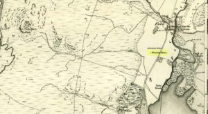
Two stones on 1875 map

Unless you’re venturing down the tiny Loch Awe roads, the easiest way here is to turn right off the A816 Lochgilphead-Oban road, 1½ miles north of Kilmartin.  Go along this winding minor road for literally 2½ miles where, after coming out the tree-lined road, just past the small Loch Ederline, the fields re-appear on both sides of the road.  Just here, where the trees end, just a few hundred yards before the hamlet of Ford, in one of the field on the left, you’ll see a tall upright stone.  That’s it!

Archaeology & History

I was very fortunate, many years ago, to live in the old farmhouse of Auchinellan in the trees by this ancient stone.  It became a companion of mine many-a-time, as I sat with it in rain and mist and darkness sometimes, beneath the bright Moon.  It always had a good feeling about it.  And so when a small bunch of us visited here again recently, it was almost as if I’d never been away.  Tis a magickal part of our landscape.
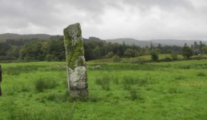
The old stone looking N
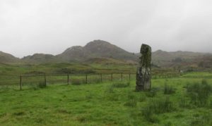
The old stone looking NW

Standing ten-foot-tall on a grassy plain with craggy hills all round, this old fella once had a companion close by its side—a stone one!  Accounts of it are curious to say the least, with one telling us that it was only “a few inches high” – which is just daft.  The now-lost stone was in fact about six-feet tall and the story of its disappearance was that it was moved into the grounds of Auchinellan House where I used to live, somewhere in the garden.  I could never find it, and local folk told me that the old fella who lived in the mansion would have known about it, but died shortly before I moved in.  Clive Ruggles (1984) told that it could be found at grid-reference NM 8653 0268, but that would be smack bang on the manor house.

As far as I can tell, the first written testimony of this stone was by the Ordnance Survey lads after they’d visited here in 1871 and, several years later, highlighted it on their maps. (above)  On this is clearly shown, just yards apart, the two standing stones.  Much later, when the Royal Commission (1988) doods did their survey, they described the stone in their usual brief way:

“Situated on the top of a slight rise in a pasture field 270m SW of the Ford Hotel, there is a standing stone which measures 0.7m by 0.55m at the base and rises with straight sides to a flat top at a height of 3m…”

The site was included in Thom’s (1990) major survey on prehistoric stone rows where, again, only a brief description is given, saying:

“On a terrace near Loch Ederline is a standing stone which leans to the E.  It is 9ft 6 (2.9m) high.”

It’s a beautiful place in a beautiful setting and is one of countless prehistoric monuments in this part of Scotland.  Well worth having a look at.

Folklore

The Gaelic names for this site—Achnacarra and Achadh nan Carradh—means “the field of the burial stone”, which relates to the folklore of the stones reputedly marking the place of an ancient grave.

References:

  1. Campbell, Marion, Mid Argyll – An Archaeological Guide, Dolphin: Glenrothes 1984.
  2. Campbell, Marion & Sandeman, M., “Mid Argyll: An Archaeological Survey,” in Proceedings Society of Antiquaries Scotland, volume 95, 1964.
  3. Royal Commission on the Ancient & Historical Monuments of Scotland, Argyll – Volume 6: Mid-Argyll and Cowal, HMSO: Edinburgh 1988.
  4. Ruggles, Clive L.N., Megalithic Astronomy, BAR: Oxford 1984.
  5. Thom, Alexander, Thom, A.S. & Burl, Aubrey, Stone Rows and Standing Stones – volume 1, BAR: Oxford 1990.

Acknowledgements:  Big thanks to Neens Harris, Paul Hornby & Frank Mercer.  And the stunning resource of Scotland’s 1st edition OS-maps is Reproduced with the kind permission of the National Library of Scotland

Links:

  1. Auchinellan (Ford) Stone on The Megalithic Portal

© Paul BennettThe Northern Antiquarian


Dun Toiseach, Ford, Kilmartin, Argyll

Dun:  OS Grid Reference – NM 880 047

Getting Here

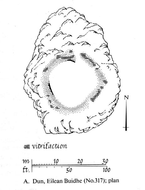
Dun Toiseach plan (after RCAHMS 1988)

You can see the rocky hillock ‘pon which this old dun sits from the roadside – and can approach it by either climbing up the slope, or go round t’ back and approach it from t’ track. Either way, it’s easy to get to.

Archaeology & History

The old dun was rather ramshackled when I used to sit here, sometimes on mi way home from working at the Inverliever Nursery, a bit further up the lochside — but it was a good spot to sit and daydream into Loch Awe and beyond…

Described as a vitrified fort, the structure is oval in shape.  Thought to have been constructed in the Iron Age, Dun Toiseach was originally about 50 feet across and its walls averaged 10 feet thick, with an entrance at its northeastern side.  The Royal Commission lads (1988) described it thus:

“Situated on a prominent rocky knoll overlooking the S end of Loch Awe 250m ESE of Torran farmsteading, there is a severely ruined dun measuring about 16m by 13m within a wall which has been some 4m thick. Two stretches of outer facing-stones are visible, as well as a few possible stones of the inner face, but, particularly on the NE, the wall has been severely robbed and the core material scattered. The entrance lies on the NE, the innermost portion of the SE passage-wall and what may be a door-jamb on the opposite side still being visible.  The knoll has acted as a focus for recent field-walls, but there is no indication that it was additionally defended by outworks. A small modern cairn…surmounts the dun wall on the SE.”

References:

  1. Royal Commission on the Ancient & Historical Monuments of Scotland, Argyll – Volume 6: Mid-Argyll and Cowal, HMSO: Edinburgh 1988.

© Paul Bennett, The Northern Antiquarian

Dun Dubh, Ford, Argyll

Dun:  OS Grid Reference – NM 8640 0479

Also Known as:

  1. Canmore ID 22821

Getting Here

From Ford village, take the track that goes uphill (west) running near the edge of the forest-line. Keep going until you hit the top of the forest and the large rocky hill above you (on your right) is where you need to be heading.  The rise to your left is Dun Chonallaich.  Walk around the bottom of the hill until you get to the other side (you should be 100 yards or more above the tree-line) where you’ll notice a ‘pass’ running west, with a rocky knoll above you on your right.  That’s it!

Archaeology & History

Thought to date from the Iron Age, the remains here cover an area 15 yards by about 25 yards.  Remains of walling around the edge of the summit nearly a yard wide in places define quite clearly where the ‘fort’ was centred.  The entrance to the site was found on the northwestern side.  In more recent times however, animal pens have intruded on the remains here and the archaeological remnants are much denuded.

Folklore

Samhain fires were lit on the larger ridge above this ruined fort until recent years, as some old local folk will tell you. These Halloween fires (done to celebrate the old New Year) were stopped a short time after the new ‘owner’ of the Auchinellan Estate (on whose land Dun Dubh is found) took exception to them and, for all intent and purpose, deemed them a fire hazard! The lady in question who inherited the Estate was in fact a devout christian who took exception to the local “pagan” goings-on, contrary to the beliefs of the previous Estate owner, who not only allowed such old events, but played a part in them.  Local folk hereabouts, not surprisingly, aint too keen on their part-time dictatorial christian neighbour.

The fires up here were also related to the linear cemetery at Kilmartin. Here the giant tombs all line up & point to Dun Chonallaich, behind which hides the more flattened top of Dun Dubh. When the Halloween fires were lit on top of this, the glow from behind the great pyramid of Chonallaich all the way down to Valley of the Kings, was spectacular! One wonders just how long the local people had been doing this…

References:

  1. Royal Commission on the Ancient & Historical Monuments, Scotland, Argyll – volume 6, HMSO: Edinburgh 1988.

© Paul Bennett, The Northern Antiquarian


Ford, Kilmartin, Argyll

Tumulus:  OS Grid Reference – NM 86899 03572

Getting Here

Ford Tumulus on 1875 map

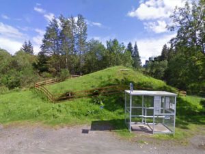
Although I describe this site in association with the township of Kilmartin, it is in fact several miles north of there – but I reckoned that if I say it’s near Kilmartin, then those of you who don’t really know this region, will have some idea of its locale.  So – from Lochgilphead, go up north thru Kilmartin, another coupla miles on, till you reach the small road to your right (signposted ‘Ford’).  Just keep driving for a couple more miles until you hit the village.  If you park by the only shop, you’re just past the old tomb.  Diagonally across on the opposite side of the road from the Ford Hotel, right by the road-junction, just before the little shop, you’ll see a notable rounded mound overgrown in shrubs. Embedded in this are the remains of an old tomb.

Archaeology & History

Ford tumulus (photo, couresty J. Reid)

This typical-looking fairy-mound just by the road junction in the village is where me and my daughter used to scramble around, sometimes playing and sometimes seeing if we could find anything of note in this ancient hillock, but all trace of any prehistoric stonework seems to be well-buried.  When excavators explored the site in bygone times, a small stone cist was found, which aligned (yet again) north-south and measured internally, roughly, 3ft x 2ft.  Only small!

A food vessel in Edinburgh’s central museum, “found in a cist in the neighbourhood of the lower end of Loch Awe” is thought to have come from this tomb.

References:

  1. Royal Commission on the Ancient & Historical Monuments of Scotland, Argyll – volume 6: Mid-Argyll and Cowal, HMSO 1988.

© Paul Bennett, The Northern Antiquarian