From Littleborough, take the Ripponden and Halifax A58 road up-uphill till you get to the White House pub near the very top. From here, cross the road and walk along the track below the disused quarry for a coupla hundred yards till you meet with the straight uphill track. Go up here and, near the very top, you’ll see the upright stone right beside the footpath on your left.
Archaeology & History
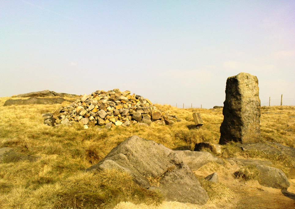
Aiggin Stone and cairn
This ancient boundary stone has long been an etymological oddity. It aint a prehistoric stone by any means (soz…), though its nature has never truly been decided for sure. Some have posited it as Roman in origin, others that it’s merely a waymarker (in case y’ get lost in the fog up here), others that it’s a milestone, and the more common notion is that it’s a boundary marker of the counties of Yorkshire and Lancashire (it’s position in the landscape presently sits it in Lancashire). As far as I’m concerned, the stone’s late-medieval in nature…
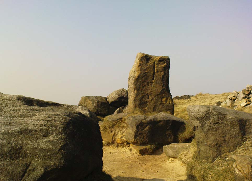
Standing by the old Roman road a short distance from the very top of these high Pennine hills on the Yorkshire-Lancashire border, a faint old Latin cross, plus the letters “I.T.” are etched onto its sides. In the 1930s the stone was found laid in the moorland heather, but was thankfully resurrected in 1933. Since then however, it’s been knocked over a couple more times, but presently stands proudly upright — until the day comes when some other halfwits decide to knock it down again! In its earlier days, James Maxim (1965) described the stone thus:
“It is an irregular block of gritstone 7 feet long, tapering from 2 feet 6 inches to 2 feet wide and it is about 10 inches thick. On one bedding face and a few inches from the top is an incised cross with the ends of the arms slightly expanded. This is 1 foot 4 inches long and 10 inches wide, the horizontal bar crossing the vertical at about 5 inches from its upper end.”
Looking northeast
First highlighted on an engineer’s map from 1800, Herbert Collins (1950) assumes Aiggin to be “a corruption of Agger”, being a Latin word meaning, “a pile, heap, mound, dike, mole, pier – in Roman antiquity, an earthwork or other artificial mound or rampart.” Due to the monolith’s proximity to the supposed Roman road there is great likelihood in it being as such, plus “agger” can also mean a Roman road or military way. Collins cites other possibilities: aggerere, “to bear to a place, to heap up,” or “that which is gathered to form an elevation above a surface” – which is certainly applicable here! James Maxim (1965) thought,
“The name ‘Aiggin’ suggests a pronunciation resembling either ‘edge’ or ‘hedge’ and thus it might mean ‘Edge Stone’. Alternatively it could be derived from the French ‘aguille’, meaning a needle or sharp-pointing rock.”
The view from here is truly excellent — though if you walk to the rocky crags of Blackstone Edge a half-mile to the south (y’ can’t miss ’em from here) and sit by Robin Hood’s Bed, it gets even better! A smaller, possible standing stone can be seen just 200 yards northwest of our Aiggin Stone; with the top of the stone seemingly knocked off in bygone years. Not far from here are the remains of some old hut circles, emerging from beneath the old landscape.
References:
Collins, Herbert C., The Roof of Lancashire, J.M. Dent: London 1950.
Maxim, James L., A Lancashire Lion, J.L. Maxim Trustees: Leeds 1965.
It is best to start at the Punch Bowl Inn car park, Sefton, then travel a short distance along Lunt Road by St Helen’s church. A footpath/lane is reached where a barrier stands and about 10 metres opposite the main road beneath the undergrowth is St. Helen’s holy well, or what remains of it.
Archaeology & History
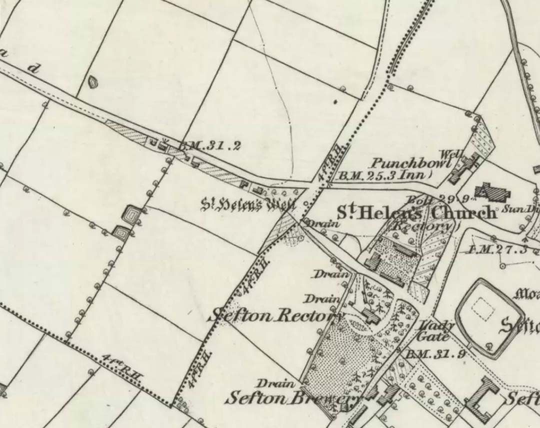
St Helen’s Well on 1850 map
The well is now, sadly, capped off with an inscribed stone that recalls ST HELEN’S WELL. The well originally stood inside a rather nice little wellhouse with a pyramid-shaped, overlapping roof, with railings running around it. It was renowned for its icy waters which were especially good for people suffering from rheumatism, sprains, bruising and, also nervous problems. It had a hand pump at the side of the well-house to enable people to drink the water. But all this has now gone, though the church congregation still visit the site on the saint’s feast day and are still hoping that some day the well will be restored again.
It was probably a pre-Christian spring that in the Middle Ages turned into a pilgrimage site, especially so in the 14th century when the church was built close by.
Folklore
In pre-Reformation times it was much in use, but later on and in more recent times it had become a wishing well; pins were thrown into the well by young folk. Apparently, if the pin could be seen at the bottom of the well a favourable outcome was likely with regard to good luck in a forthcoming marriage by a couple much in love.
Addenda:
To complement Ray’s entry, here are Mr Taylor’s notes from his Ancient Crosses and Holy Wells (1906), in which he wrote the following:
“This celebrated spring rises at a distance of three hundred yards in a westerly direction from Sefton Church. In the year 1891 the well was walled round, and a handsome canopy placed over it, from the designs of Mr John Douglas, at the cost of William Philip, fourth earl of Sefton. The traditions connected with this holy well are thus graphically summed up in the History of Sefton:-
“”We must not omit to mention St Helen’s Well, which springs near the first cottage in the Thornton Road, beyond the inn. Formerly a ‘pad-road’ only led from the well to the church, the Thornton Road passing through the Rectory grounds. In the Churchwarden’s accounts we find several items of expenditure incurred for the keeping in order of St Helen’s Well. Thus we read in 1758: ‘For a new Dish and Chain for S. Ellen’s Well, 2/-.’ Ashcroft [writing about the year 1819] tells us ‘that this well was once in great repute for curing rheumatism, strains, bruises and weaknesses of the nerves. It has no mineral quality, however, and he remarks that its principal virtue seems to have been its coldness.’ In different times great respect was paid to wells ’eminent for curing distempers upon the Saint’s Day whose name the well bore,’ and it was once the custom to decorate the wells of Holy Thursday with boughs of trees, garlands of flowers, etc, places in various devices, and after service in the church the parson and singers repaired to the well, where they sang psalms and prayed. The bottom of the well, which is of no great depth and very clear, may generally be strewn with pins which are dropped in by superstitious young country folks to denote to them the probability of their marriage, which is said to be near if the pin falls pointing towards the church. Pins and pebbles were often dropped into wells, and the circles formed thereby on the surface of the water (or the question whether the water was troubled at all) were used as omens by which the observers drew inferences of future events. Mr Hampson, in his Medii Ævi Kalendarium, says: ‘I have frequently seen the bottom of S. Helen’s Well, near Sefton, Lancashire, almost covered with pins, which I suppose must have been thrown in for like purposes.'”
“…Mr Gregson wrote: ‘With regard to the curious frequency of well dedication to S. Helen, I formed a theory many years ago that the S. Helen of the county of Lancaster is not unconnected with the Celtic S. Elian, who is a frequent patron saint of wells in North Wales. Do they not both draw a common ancestry from Ella, the water sprite?'”
References:
Caroe, W.D. & Gordon, E.J.A., Sefton: A Descriptive and Historical Account, Longmans Green: London 1893.
Taylor, Henry, The Ancient Crosses and Holy Wells of Lancashire, Sherratt & Hughes: Manchester 1906.
From the lovely village of Summerbridge (near Pateley Bridge), go up the steep Hartwith Bank road, going straight across at the crossroads for another few hundred yards, passing the old tombs of Graffa Plain on your right…and they’ll start appearing on your left-hand side (west). Do not go into the expensive National Trust car-park. Instead (if you’ve already gone too far), about 100 yards before the Car Park you’ll find a small dirt-track on your left a short distance away. But if you drive past the rip-off car park, another 100 yards on there’s another spot where you can easily park up on the right-hand side of the road. Then cross the road and follow y’ nose…
Archaeology & History
The OS grid reference given above is an approximation — for obvious reasons. This is a huge area that’s covered by Britain’s finest natural megalithic features, obviously sculptured by Nature Herself — though many are the historians who sought to give Druids the credit here. God knows how! The area over which these magnificent rock sentinels live covers some 60 acres and is some 1000 feet above sea level. The view from the hill around which the encircling parade of rocks guards is excellent, allowing our eyes to catch focus on the distant lands of Whernside, Simon’s Seat, York Minster, the Cleveland Hills and Kilburn’s white horse. It’s quite a view.
Easternmost Rocking StoneIdol Stone (Godfrey Higgins 1826)
But this tends to be overlooked when you first visit the place, as the rocks which surround and walk alongside you overwhelm with impressions not encountered before. To those with spirit, you’ll be bouncing and running all day here, clambering upon rocking stones, jumping between dodgy gorges that await falls, and just aching to climb pinnacles that deny you. But then, if you need the selfishness of silence, this arena will only grant such solace when the rains are about, or dense fog and low cloud keeps others from this haunting amphitheatre. And it’s not surprising… The mass of rocks contort into the most beautiful and curious simulacra, which would not have gone unnoticed, nor deemed unimportant in the sacred landscape of our ancestors…
Brimham Rocks have been written about since the 17th century, though they didn’t receive the serious attention of outsiders until the 19th, when numerous Victorian writers — from antiquarians and geologists, to archaeologists and Druids — got to hear about the place. And by the beginning of the 20th century, a veritable mass of articles had been written in journals and travelogues of all persuasions! These quiet Yorkshire Rocks had become truly famous!
Brimham Rocks (Walbran 1856)Old Woman and her consort
A lengthy essay was written in the distinguished archaeology journal of its time, Archaeologia, by northern historian Hayman Rooke (1787), who thought that some of the rocks here had been tampered with by the druids; with the legendary Cannon Rock in particular possessing oracular properties. The site as a whole was, he posited, a temple for Druids in ancient days. Certainly the place would have been deemed as sacred, whether by the druids or our more remote neolithic and Bronze Age ancestors.
Harry Speight & his mates, c.1890
In Harry Speight’s magnum opus, Nidderdale (1894), he described these rocky giants as best as he could, admitting as others before and since, that no mere words can convey the impression that only a personal encounter liberates, saying:
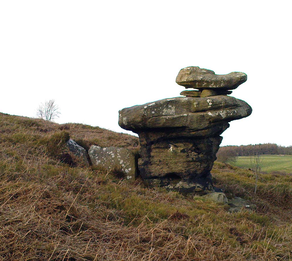
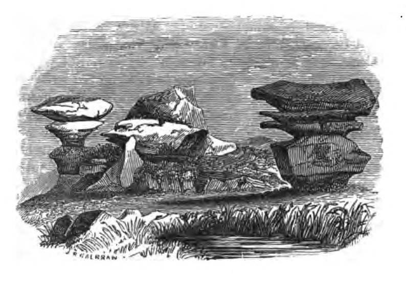
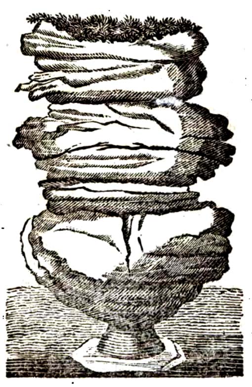
“The Brimham Rocks are among the greatest natural wonders of Yorkshire, and many have been the theories from time to time advanced as to the cause of their extraordinary aspects… The resemblances to natural and artificial objects are most striking. There we have the Elephant Rock, the Porpoise Head, the Dancing Bear (a very singular, naturally-shaped specimen), the Boat Rock, showing the bow and stern completely, etc. Then there is the great Idol Rock, a most mysterious-looking object, of almost incredible size and form. It is a perfectly detached block, fully twenty feet high, weathered along face joints into three roughly circular pieces, each from 40 to 50 feet in circumference, piled one above the other; the whole mass, weighing by estimation over 200 tons, being poised on a pyramid 3½ feet in diameter; the pivot itself supporting this immense column having a diameter of barely 12 inches.
“East of the guide’s house are the famous Rocking Stones, consisting of a group of four rocks, which were discovered to be movable in the year 1786. The two on the west side weighing approximately 50 and 25 tons, require but little force to vibrate, while those on the east side, though much smaller are not so well poised and do not move readily. Each of the larger stones has a basin-like cavity on the top, and a kind of knee-hole open to the north, said to be the work of Druids. Close to the Rocking Stones are the appropriately-named Oyster-shell Rock, and the Hippopotamus’ Head. Turning now some thirty yards north of the Idol Rock we ascend Mount Delectable, where is the agreeable Courting or Kissing Chair, happily at not too close quarters with the above Hippopotamus’ Head and Boar’s Snout. The Chair consists of a single seat, but why it should be so called, I had better leave the amorous lover to solve. West of these is the more sober Druid’s Reading Desk, with its church-like lectern on a stout stone base. The we come to the Lover’s Leap, a gigantic and abrupt face of beetling crag, weathered to the west, and rising to a height of 60 to 70 feet, with three immense fragments balanced in a very remarkable manner at the summit. The rock is in tow principal sections, and an iron hand-rail has been fixed across the chasm to enable visitors to look down from the top. Further south are the Frog and Tortoise Rocks, the latter presenting from one point of view a capital resemblance to a tortoise creeping up the face of the crag towards the imaged frog. A little below this is a good imitation of a cannon, projecting from the edge of the cliff. In addition to these singular resemblances there are many others which the guide points out, such as the Yoke of Oxen, Mushroom Rocks, Druid’s Oven, Dog’s Head, Telescope, and the curiously perforated Cannon Rock, etc.”
In a later work, Speight (1906) also mentioned the existence of a Druid’s Circle some 300 yards west of the main natural temples, but this site appears to have been destroyed. Thankfully the large standing stone on Hartwith Moor, a mile to the south, can still be found upright…
Folklore
Idol Stone (Hargrove 1809)
In folklore, there’s little surprise this place was held by just about every 18th and 19th century historian as a ‘druidic site.’ But more interesting – in the light of Paul Devereux’s (2001) work on acoustic archaeology – is what Edmund Bogg (c.1895) said of these huge contorted stones:
“In bygone days these immense stones were supposed to be the habitation of spirits. The echo given from the rocks was said to be the voice of the spirit who dwelt there, and which the people named the Son of the Rocks. From a conversation we had with the peasantry not far from here, it seems the ancient superstition had not yet fully disappeared.”
This is precisely the notion of spirit given to rocky places elsewhere in the world, where the very echo was perceived as the ‘voice of the rocks’. Meditate on it a bit, in situ. (a fine summary of this notion and its implications — which has crept into archaeology of late — can be found in Paul Devereux’s work, Stone Age Soundtracks)
One of Brimham’s southwestern rocks was known as the Noon Stone when Mr Rooke (1787) came here. There are many stones with this name scattering Yorkshire and other northern counties, each with the same mythic background: that the sun casts a shadow from it at midday to indicate the time of day. Of this Noon Stone Mr Hooke also told us that,
“On Midsummer Eve fires are lighted on the side. Its situation is apposite for this purpose, being on the edge of a hill, commanding an extensive view. This custom is of the most remote antiquity.”
On the very southern edge of Brimham’s Rocks (some might say beyond their real border) is the Beacon Rock — and it is aptly named: as in the year 1887 on the day of Queen Victoria’s Jubilee, a great beacon fire was lit here, signalling to others in the distance. Its title however, pre-dates Victoria’s Jubilee, though we don’t know how far back in time it goes…
…to be continued…
References:
Bogg, Edmund, From Eden Vale to the Plains of York, James Miles: Leeds c.1895.
Devereux, Paul, Stone Age Soundtracks: The Acoustic Archaeology of Ancient Sites, Vega: London 2001.
Grainge, William, The History and Topography of Harrogate and the Forest of Knaresborough, John Russell Smith: London 1871.
Harrison, William, A Descriptive Account of Brimham Rocks in the West Riding of Yorkshire, A. Johnson: Ripon 1846.
Michell, John, The Earth Spirit: Its Ways, Shrines and Mysteries, Thames & Hudson: London 1975.
Michell, John, Simulacra, Thames & Hudson: London 1979.
Rooke, Hayman, “Some Account of the Brimham Rocks in Yorkshire,” in Archaeologia journal, volume 8, 1787.
Speight, Harry, Nidderdale and the Garden of the Nidd, Elliot Stock: London 1894.
Speight, Harry, Upper Nidderdale, with the Forest of Knaresborough, Elliot Stock: London 1906.
Walbran, John Richard, A Guide to Ripon, Fountains Abbey, Harrogate, Bolton Abbey, etc, Johnson: Ripon 1856.
The site has been known about for nearly 150 years, albeit mistakenly as a series of prehistoric barrows that William Greenwell (1877) told were “near the division between the parishes of Rudston and Burton Agnes” near the crest of the hill. He further told the place to be,
“Two long mounds, almost parallel, their northern end gradually losing themselves in the surface-level, but connected together at the southern end by another long mound.”
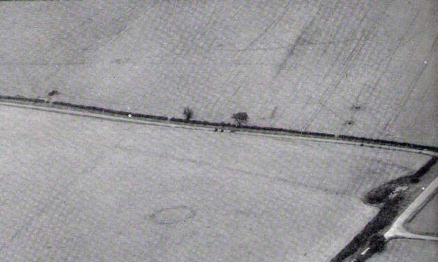
South end of Cursus A (after D.P. Dymond)Early photo of Cursus A (after J.K.St Joseph)
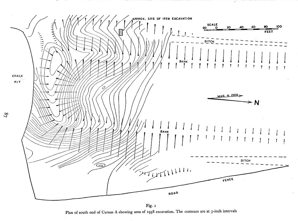
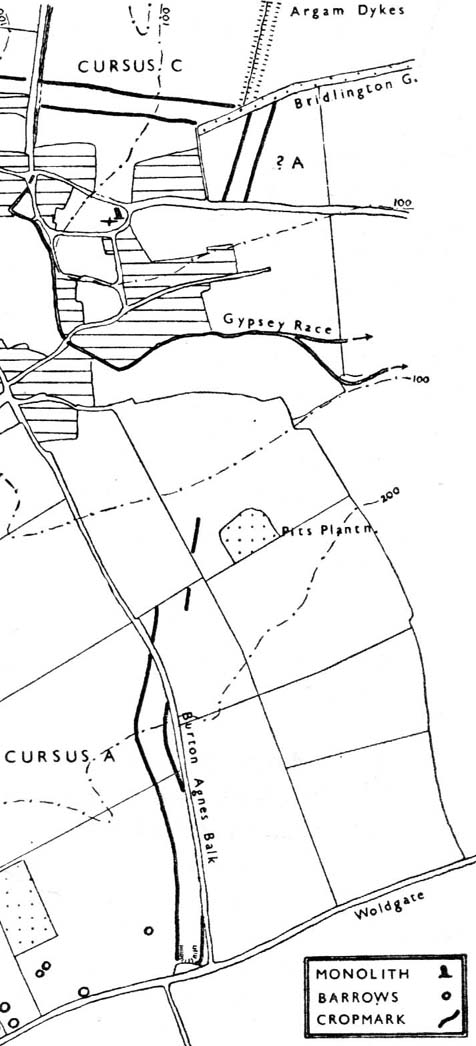
Then in 1958 when C. & E. Grantham of Driffield did the first modern excavation here across a section of the western ditch, they found that the long embankment went on much further than ever previously anticipated, for more than half-a-mile downhill in the direction of Rudston village. It wasn’t a long barrow or tombs of any sort, they found! Then in 1961 when Dr. J.K. St. Joseph did aerial survey work over the area, he and his colleagues established that this monument consisted of extensive parallel ditches stretching for at least 1½ miles towards and past the eastern side of Rudston village. It’s nature as a cursus monument was rediscovered after several thousand years in the wilderness… (on St. Joseph’s survey, two other cursus monuments were also found in the vicinity, being Rudston Cursus B and Cursus C) Readers will hopefully forgive me for quoting at some length Mr Dymond’s (1966) article on the site (with minimal editing!):
“The southern end of the cursus lies in the western angle of two roads, Woldgate and Burton Agnes Balk. In plan it is square with rounded corners and consists of a bank with outer ditch. Although the bank has been ploughed for many years, it still remains substantial; it stands up to 4 feet high from the outside and 1-2 feet wide from the inside. The east and west banks decline in height northwards and are now at their greatest height where they join the southern end. The profile of each bank is smooth and rounded and merges on the outside with the broad shallow depression of the silted-up ditch. The south bank is now 170 feet long overall, and spread to a width of 60-80 feet. It stands higher at both ends than in the middle. This fact was noted by Greenwell, who also recorded that at the southwest angle “there was the appearance of a round barrow raised upon the surface of the long mound.” There is no surface evidence today to suggest a secondary round barrow, and to some extent at least the greater height at the angles is probably due to the concentration of upcast inside a fairly sharp corner.
“The south arm of the ditch has been largely destroyed by a chalk-pit, but the southeast turn is quite clear on air-photographs. There is no suggestion on the ground or from the air that the cursus had ever extended further to the south.
“The cursus begins its descent in a due northerly direction, and loses its eastern side for approximately 600 feet under the enclosure road, Burton Agnes Balk. The ditch can be traced intermittently on the western and eastern verges. It then swings gently NNW around the head of a small slack draining northwest. Thus far the cursus is traceable on the ground. The ditches are the most consistent feature, showing as broad shallow depressions 20-40 feet wide and 70-80 yards apart, which when in fallow attract a dark coarse vegetation (particularly thistles and nettles. The banks inside the ditches are sometimes visible in relief though considerably spread. Where the banks have been almost entirely ploughed out, a chalk spread usually marks their position.
“There is a suggestion on the ground that the banks and ditches may have been separated by berms, particularly on the east side near the square end. This appears to be confirmed by the silting of the ditch in the excavated section…
“Proceeding further downhill in the direction of Rudston village, the cursus quite suddenly swings north-NNE, finally crosses Burton Agnes Balk, and passes to the west of Pits Plantation. On the west of the road both banks and ditches are still visible in relief, and the ditches produce a firm crop-mark. East of the road no surface traces are discernible, and only the eastern ditch shows intermittently as a crop-mark.
“For ½-mile across the floor of the Great Wold Valley, there is no trace of the cursus. The area has been ploughed since medieval times, and there is in addition a considerable Romano-British settlement. It is worth noting that in this length, the cursus must have crossed the stream of the Gypsey Race, surely a fact of some importance in any discussion of the function of cursuses.
“Two parallel ditches c.60 yards apart, visible on air photographs in a field immediately north of the modern Rudston-Bridlington road, seem to represent the continuation of the cursus. The ditches travel for approximately 300 yards and end at the Bridlington Gate Plantation. There are no surface traces in the field, but a depression in the plantation may represent the eastern ditch. This depression is crossed obliquely by the remains of a low bank and ditch running along the length of the plantation WSW and ENE. This latter (part) is probably part of the supposedly Iron Age entrenchment system, and has certainly been used as a road from Rudston to Bridlington, as the name of the plantation implies.
“The northern end of the cursus cannot be traced. Possibilities are that the end was in the plantation and has been destroyed by the later earthwork, or that the cursus proceeded NNE for an unknown distance. If the latter hypothesis is accepted, the western ditch must be under the Argam Dykes, a double entrenchment which appears to terminate at the northern side of the plantation, and the eastern ditch is indistinguishable from ploughing lines to which it is parallel…
“Cursus A has its southern end at a height of 254 feet OD, on the forward face of a long chalk ridge running WSW and ENE. From this point the course of the cursus is visible, except for that part west of Pits Plantation. The last known part in Bridlington Gate Plantation, 1½ miles off, is clearly visible. Seen against the contours of the area, the cursus has one end resting on a high ridge, crosses a broad valley, and climbs at least in part, the far side. It appears to pass approximately 300 yards east of the monolith in Rudston churchyard.”
Line of Rudston A
The presence of this and three other cursus monuments close by (Rudston B, C and D) indicates that the region was an exceptionally important one in the cosmology of our prehistoric ancestors. Four of these giant linear cursus monuments occur in relative proximity, and there was an excess of ancient tombs and, of course, we have the largest standing stone in the British Isles stood in the middle of it all. A full multidisciplinary analysis of the antiquities in this region is long overdue. To our ancestors, the mythic terrain and emergent monuments hereby related to each other symbiotically, as both primary aspects (natural) and epiphenomena (man-made) of terra mater: a relationship well known to students of comparative religion and anthropology who understand the socio-organic animistic relationship of landscape, tribal groups and monuments.
References:
Dymond, D.P., “Ritual Monuments at Rudston, E. Yorkshire, England,” in Proceedings of the Prehistoric Society, volume 32, 1966.
Eliade, Mircea, The Sacred and the Profane, Harvest: New York 1959.
Greenwell, William, British Barrows, Clarendon Press: Oxford 1877.
Hedges, John & Buckley, David G., The Springfield Cursus and the Cursus Problem, Essex County Council 1981.
Nicholson, John, Beacons of East Yorkshire, A. Brown & Sons: Hull 1887.
Pennick, Nigel & Devereux, Paul, Lines on the Landscape, Hale: London 1989.
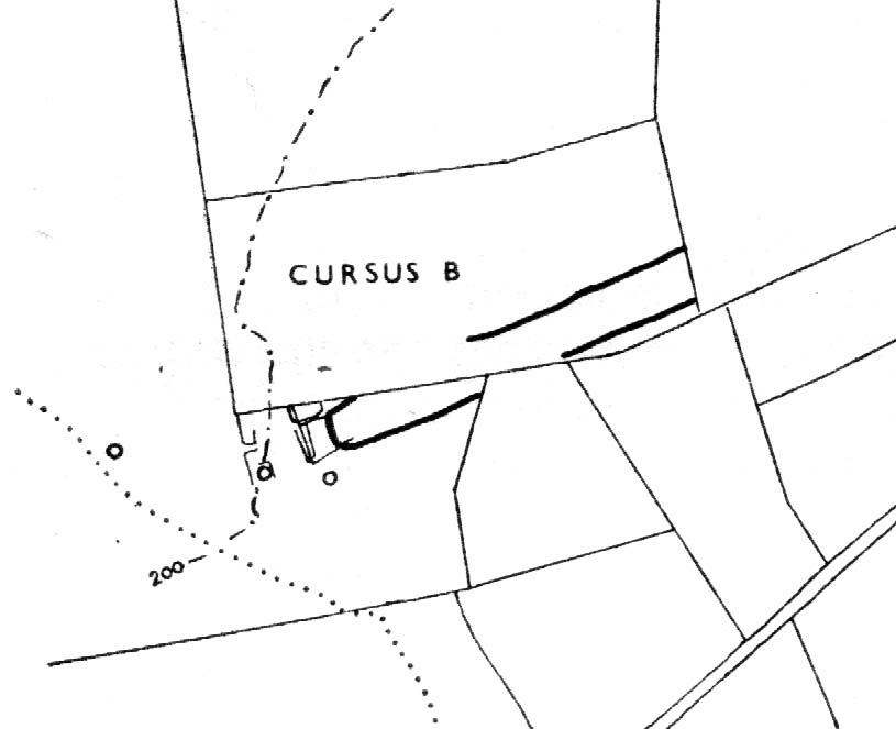
One of the four (known) cursus monuments around Rudston: this one stretches between the Ordnance Survey coordinates TA 081669 near Kilham Grange on the southwestern edge of Rudston, then heads northeast towards the village itself at TA 094675. Described briefly in D.P.Dymond’s essay on (mainly) Cursus A, he said how Cursus B was part of,
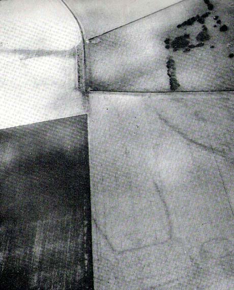
Early ground-plan (after D.P. Dymond)Early photo of Rudston B (after J.K.St Joseph)
“a large complex of crop marks. The largest feature is the squared, tapering end of Cursus B, which can be traced for 700 yards in a north-easterly direction. No surface remains seem to survive in an area intensively ploughed, except for a swelling under a hedge on the line of the south-eastern bank (at TA 0834 6703). West of the square end and partly overlying it, are several small rectangular enclosures, which are probably part of a later (?Romano-British) settlement and field-system. Also in this tangle of crop-marks there are four roughly circular shapes, which may well be barrow circles associated with the end of the cursus. On certain barrow just south of the end of the cursus has an inner ring of pits. Where the cursus is lat visible to the north-east, it is headed roughly for the monolith ¾-mile away. The width of Cursus B is approximately 90 yards between ditch centres. It has its square end on the forward slope of a ridge (like Cursus A) at a height of 180 feet OD, and descends towards the village, which is visible from the end, through a shallow valley.”
Dymond’s note about the alignment feature of this cursus, towards the gigantic Rudston monolith, was one echoed in the Hedges & Buckley (1981) survey. They noted:
“At Rudston, the B cursus extended eastwards aligns upon the Rudston monolith in Rudston churchyard. Destruction of standing stones elsewhere may have removed similar associations between the stones and cursuses.”
This alignment feature was also confirmed by cognitive archaeologist and alignment specialist, Paul Devereux (Pennick & Devereux 1989) in his survey of cursus monuments.
Typical of these fascinating antiquities, nothing of any worth has been found along the length of the cursus that can give us any clues to its nature and function. However, the presence of this and three others close by indicates that the region was an exceptionally important one in the cosmology of our prehistoric ancestors. Four of these giant linear cursus monuments occur in relative proximity, and there was an excess of ancient tombs and, of course, we have the largest standing stone in the British Isles stood in the middle of it all. A full multidisciplinary analysis of the antiquities in this region is long overdue. To our ancestors, the mythic terrain and emergent monuments hereby related to each other symbiotically, as both primary aspects (natural) and epiphenomena (man-made) of terra mater: a phenomenon long known to comparative religious students and anthropologists exploring the animistic natural relationship of landscape, tribal groups and monuments.
References:
Dymond, D.P., “Ritual Monuments at Rudston, E. Yorkshire, England,” in Proceedings of the Prehistoric Society, volume 32, 1966.
Eliade, Mircea, The Sacred and the Profane, Harvest: New York 1959.
Hedges, John & Buckley, David G., The Springfield Cursus and the Cursus Problem, Essex County Council 1981.
Pennick, Nigel & Devereux, Paul, Lines on the Landscape, Hale: London 1989.
Follow the same directions to find the Blackheath Circle, but instead of turning onto the golf course, keep going up the steep road until you reach the T-junction at the top; then turn left and go along the road for about 200 yards, past the second track on the left, keeping your eyes peeled across the small moorland to your left where you can see the rocks rising up. Walk along the footpath towards them. You can’t really miss the place!
Archaeology & History
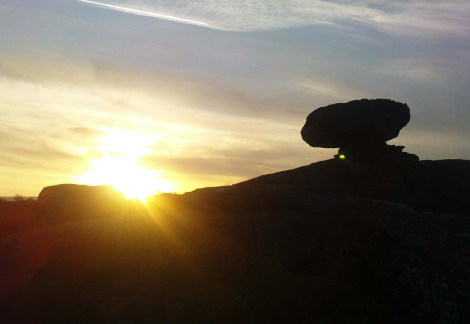
The Bride at sunset – the fallen Groom to her left
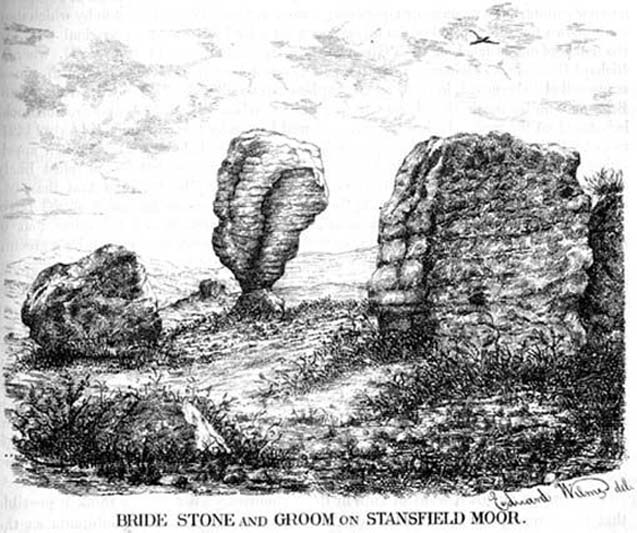
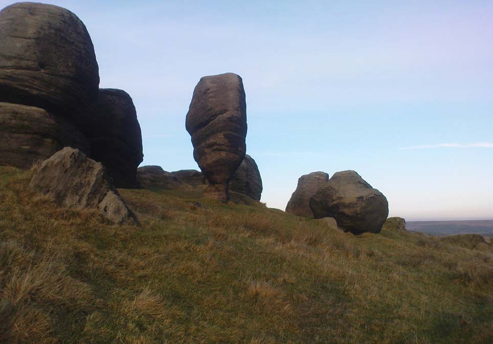
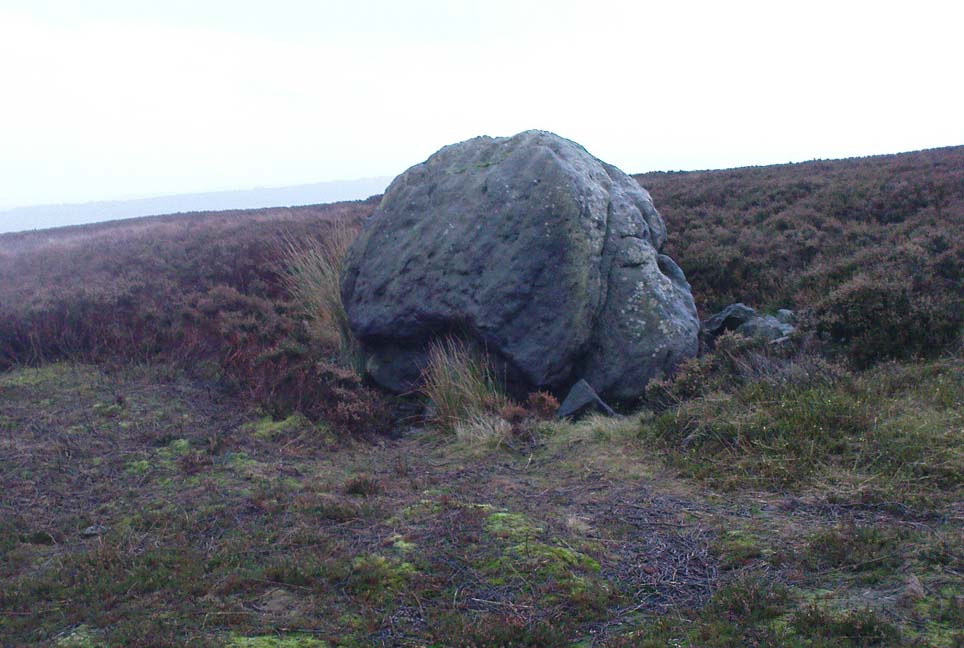
If you’re a heathen or geologist and you aint seen this place, check it out – you won’t be disappointed! First mentioned in 1491, this has always been a place of some repute. Its legendary companion, the ‘Groom’, lays resting on the Earth after being felled sometime in the 17th century.
F.A. Leyland’s 1860s drawing
A beautiful, remarkable and powerful site of obvious veneration. First described in local deeds as early as 1491, there are a great number of severely weathered boulders all round here, many like frozen rock giants haunting a magickal landscape. The modern lore ascribes the stones to be dedicated to Bride, goddess of the Brigantian people. And like Her legendary triple-aspect, we find here in the landscape a triple aspect to the outcrops themselves: to the west are the Bride Stones; to the east, the Little Bride Stones; with the Great Bride Stones as the central group, surveying everything around here.
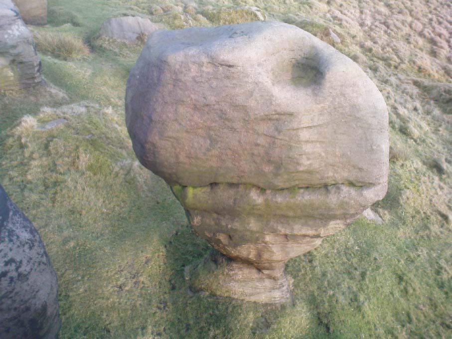
At the main complex is what is singularly known as the Bride itself: a great smooth upright pillar of stone fourteen feet tall and nine feet wide at the top, yet only about two feet wide near its base, seemingly defying natural law. Watson (1775) described, next to the Bride herself, “stood another large stone, called the Groom…(which) has been thrown down by the country people” – probably under order of the Church. Crossland (1902) told how the Bride also acquired the title, “T’ Bottle Neck,” because of the stone’s simulacrum of an upturned bottle.
The Bride & her Groom (laid on the earth)The ‘head’ or top of the Bride Stone
Scattered across the tops of the many rocks hereby are many “druid basins” as Harland and Wilkinson (1882) described them. Many of these are simply basins eroded over the millenia by the natural elements of wind and rain. It is possible that some of these basins were carved out by human hands, but it’s nigh on impossible to say for sure those that were and those that were not. If we could find a ring around at least one of them, it would help — but in all our searches all round here, we’ve yet to locate one complete cup-and-ring. So we must remain sceptical.
On the mundane etymological side of things, the excellent tract by F.A. Leyland (c.1867) suggested the Bride Stones actually had nothing to do with any goddess or heathenism, but derived simply from,
“the Anglo-Saxon adjective Βñáð, signifying broad, large, vast — hence the name of the three groups known as the Bride Stones. The name of The Groom, conferred on the prostrate remains, appears to have been suggested by the fanciful definition of the Saxon Brád, as given by (Watson).”
However, the modern place-name authority A.H. Smith (1963:3:174) says very simply that the name derives from “bryd, a bride.”
A “rude stone” was described in one tract as being a short distance below this great rock outcrop; it was turned into a cross by the local christian fanatics and moved a few hundred yards west, to a site that is now shown on modern OS-maps as the Mount Cross.
Folklore
Although local history records are silent over the ritual nature of these outcrops, tradition and folklore cited by the antiquarian Reverend John Watson (1775) tell them as a place of pagan worship. People were said to have married here, although whether such lore evolved from a misrepresentation of the title, Bride, is unsure. In the present day though there have been a number of people who have married here in recent years.
If the Brigantian goddess was venerated here, the date of the most active festivities would have been February 1-2, or Old Wives Feast day as it was known in the north. The modern witches Janet and Stewart Farrar, who wrote extensively about this deity (1987), said of Bride: “one is really speaking of the primordial Celtic Great Mother Herself,” i.e., the Earth Mother.
Telling of further lore, Watson said that weddings performed here in ages past stuck to an age-old tradition:
“during the ceremony, the groom stood by one of these pillars, and the bride by the other, the priests having their stations by the adjoining stones, the largest perhaps being appropriated to the arch-druid.”
New Age author Monica Sjoo felt the place “to have a special and uncanny power.” This almost understates the place: it is truly primal and possesses the virtues of strength, energy, birth and solace.
References:
Bennett, Paul, The Old Stones of Elmet, Capall Bann: Milverton 2001.
Crossland, Charles, “Place-Names in the Parish of Halifax in Relation to Surrounding Natural Features,” in Halifax Naturalist, volume 7, 1902.
Farrar, Janet & Stewart, The Witches’ Goddess, Hale: London 1987.
Harland, John & Wilkinson, T.T., Lancashire Folklore, John Heywood: Manchester 1882.
Leyland, F.A., The History and Antiquities of the Parish of Halifax, by the Reverend John Watson, M.A., R.Leyland: Halifax n.d. (c.1867).
Smith, A.H., The Place-Names of the West Riding of Yorkshire – volume 3, Cambridge University Press 1963.
Watson, John, The History and Antiquities of the Parish of Halifax, T. Lowndes: London 1775.
If you follow the directions to reach the Churn Milk Joan stone, then continue onto the moor following the same directions to find the Miller’s Grave, once you’ve reach this you’ll see a large rounded boulder a couple of hundred yards away on your left, to the northwest. That’s Robin Hood’s Penny Stone!
Archaeology & History
Robin Hood’s Pennystone, Midgley Moor
In terms of this site’s archaeology, it has none to write home about in official records (other than a few flints found nearby), but there’s more to this place than meets the eye. A large rounded boulder sat upon the moorland plain with a large Nature-worn bowl on its top, the site is some 112 yards (102m) northwest of the little-known, but impressive Miller’s Grave prehistoric cairn (close to being a midsummer/midwinter line). North and south of the rock are small lines of prehistoric walling — though their context is difficult to assess. The Greenwood Stone and Greenwood B stone can be found about 200 yards west.
Folklore
A singular footpath once led up to this old boulder, atop of which – in its large ‘bowl’ – vinegar used to be poured. In this, coins were left by local people who suffered the plague and in return food was left for them. And of course it is said that Robin Hood frequented the place in bygone times.
References:
Bennett, Paul, The Old Stones of Elmet, Capall Bann: Milverton 2001.
Robert, Andy, “Our Last Meeting,” in NEM 37, 1989.
Robert, Andy, Ghosts and Legends of Yorkshire, Jarrold: Sheffield 1992.
To be found on the wooded hill about 160 yards north of Wallstale Farm, on the Polmaise Road on the western side of the M9, a mile or so south of Cambusbarron, below the hugely impressive Murrayshall Quarries. Walk up the steep slope into the woodland and when you reach the level you’ll find the stonework remains. It’s on the edge of the slope in the trees.
Archaeology & History
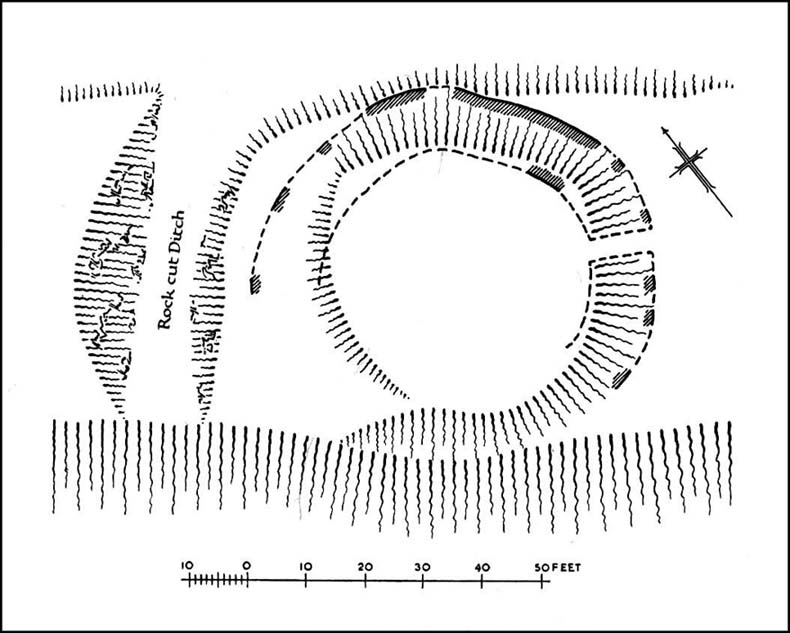
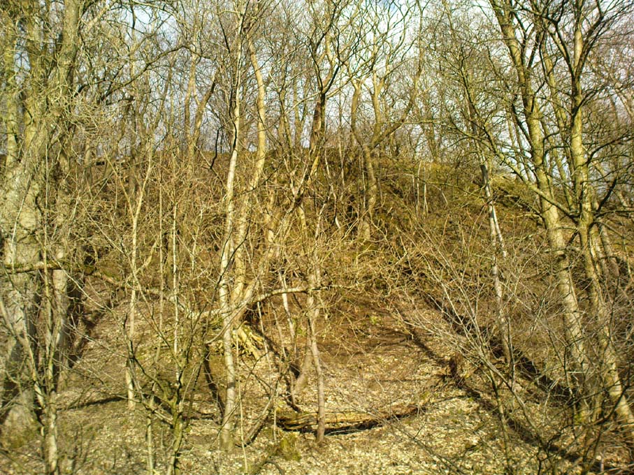
This old fortified walled structure is best seen in the winter months when all the vegetation has fallen back to Earth. If you come here in the summer, the woods are nice but the monument can’t be seen as clearly. Found at the top of the slope above the roadside, it was described in the Stirlingshire Royal Commission (1963) account as follows:
Ground-plan of Wallstale Dun (after RCAHMS 1963)Wallstale Dun, up there somewhere!
“It is almost circular in plan…measuring about 45ft in diameter within a ruined stone wall some 11ft in thickness. Except on the ESE side, where the entrance was probably situated, the wall can be traced continuously by patches of rubble core, and round the east half outer facing-stones are visible up to a maximum height of four courses. In contrast, the inner face is only exposed for a short distance on the ENE. The interior of the dun is featureless. On the NW side the dun is protected by a rock-cut ditch of substantial proportions which traverses the spur; it measures 26ft in width at the top and the scarp is 5ft 6in in depth.”
References:
Royal Commission on the Ancient & Historical Monuments Scotland, Stirling – volume 1, HMSO: Edinburgh 1963.
Stone Circle (destroyed): OS Grid Reference – SU 0986 6713
Archaeology & History
Smith’s plan of the site
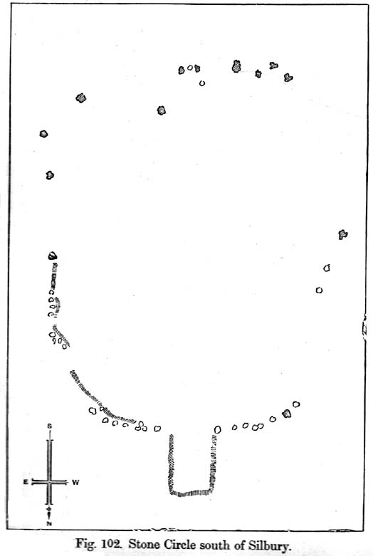
This all-but-destroyed megalithic ring is all-but-unknown in most of the archaeological gazetteers — including even Burl’s (2000) magnum opus! But we know it was there. And according to the Avebury authority Pete Glastonbury , there “are a couple or three small stones buried on the hill but nothing else to see.” Which is a pity, as the site sounds like it was something to behold in bygone times. Although it seems to have been described initially by the legendary druidical antiquarian, William Stukeley, a more lengthy description followed in the 19th century by the reverend A.C. Smith (1885), when he and a friend took it upon themselves to cut back some of the turf that was covering a number of stones — and they weren’t to be disappointed!
The site itself appears to have stood right on the southern boundary line of Avebury parish, meaning that the site could have been named and cited on any early boundary perambulation records that might exist of the parish. (do any of you Wiltshire folk have access to any such old records?) But if there are no such early accounts, the earliest record we’ll have to stick with is good old Mr Stukeley (1743), who only gave it a passing mention, saying:
“Upon the heath south of Silbury was a very large oblong work like a long barrow, made only of stones pitch’d in the ground; no tumulus. Mr Smith before-mentioned told me his cousin took the stones away (then) fourteen years ago, to make mere (boundary, PB) stones withal. I take it to have been an Archdruid’s, tho’ humble, yet magnificent; being 350 feet or 200 cubits long.”
Nearly 150 years later Reverend Smith gave us a more detailed account, and ground-plan, describing the place as,
“a stone circle, of considerable dimensions, though imperfect and formed of very small sarsens, but which I believe to have been in some way connected with Abury. Though it appears to have been mentioned by Stukeley one hundred and fifty years ago, it had been long since buried, and completely forgotten till I was fortunate enough to discover it by digging in the year 1877. I was led to the discovery by the suspicious look of certain stones which, though scattered in no regular form, appeared as if they might have once stood erect, in some sort of order, on the segment of a large circle. I had often stopped to examine them as I wandered over that part of the downs; till at last previous suspicions ripened into conviction, as closer observation revealed sundry other stones just showing above the ground, and there also seemed to be faint indications of a trench, all pointing, with more or less accuracy, to the supposed circle. Not to dwell upon the details of the investigation, which, however, were of singular interest to me, the result was that (with the permission of both owner and occupier of the land, and assisted by Mr William Long), I probed the ground in every direction, and uncovered the turf wherever a stone was found: and on our first day’s work we unearthed no less than twenty-two sarsen stones, all forming part of the circle, and lying from two to twelve inches below the surface. These stones were all of small size, some of them very small, but that they were placed by the hand of man in the positions they now occupy, in many cases nearly touching one another, and that they formed part of a large circle or oblong, admits, I think, of no doubt. I say part of a circle, because, though the northern, southern and eastern segments are tolerably well defined, I could find scarcely a single stone on what should be the western segment to complete the circle. That the area thus enclosed is not insignificant will appear from the diameter (in length, or from north to south, 261 feet; and in breadth, or from east to west, 216 feet). Again, its position (due south of Silbury, and within full view of it, as well as the Sanctuary on Overton Hill, and with Abury immediately behind Silbury, due north of it, from which also Silbury is equidistant) seems to intimate that it may have had some connection with the great temple.”
A ley running through the circle (image courtesy Paul Devereux)
Smith then proceeded to query the nature of the monument, commenting on how Sir John Lubbock and members of the British Archaeological Association were intrigued by the remains, but a little perplexed and unable “to form any opinion” as to the exact nature of the site. But this didn’t stop mythographer and historian Michael Dames (1977) who, in his classic Avebury Cycle, suggested that the site “marked the navel of the landscape goddess” in the region.
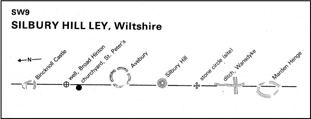
The site didn’t go unnoticed in Devereux and Thomson’s (1979) classic Ley Hunter’s Companion, where it plays an important point along a ley that runs north-south for 13 miles between Bincknoll Castle at the north, to Marden Henge at the south. Such an alignment had been noted much earlier by other archaeologists and historians.
The site does look strange for a stone circle in Smith’s ground-plan and has more the hallmarks of a type of enclosure or settlement of some sort. It certainly wouldn’t be out of place, design-wise, as a prehistoric settlement in our more northern climes. However, without further data it seems we may never know the true nature of this old stone site…
References:
Dames, Michael, The Avebury Cycle, Thames & Hudson: London 1977.
Devereux, Paul & Thomson, Ian, The Ley Hunter’s Companion, Thames & Hudson: London 1979.
The second highest of Wiltshire’s prehistoric camps or hillforts, Martinsell Hill was described as early as the 13th century as ‘Mattelsore’ and was known in local dialect and literary forms as variants around the word mattels, until the 16th century, when the title became altered in literature and for the first time became known as ‘Martinshall’ (and variants thereof), which has stuck ever since. As the etymologists Gover, Mawer & Stenton (1939) proclaimed,
“the first element (mattels, PB) must be associated with the old english name for the camp which stands on top of it: the Mætelmesburg of the Pewsey charter” —
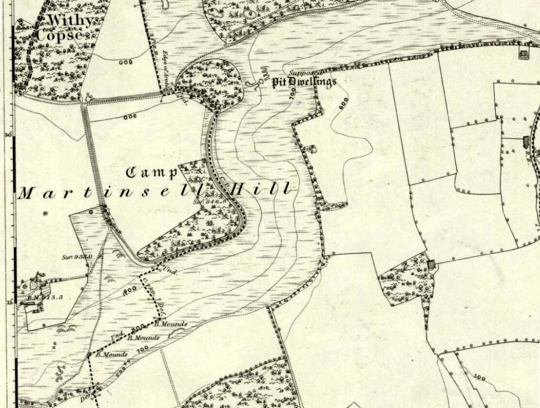
A.C. Smith’s old map
Which the authors think derived from “Mætelmesora, i.e., ‘Mæþelhelm’s bank'”, being the name of a tribal leader or elder who gave his name to the hill upon which the fort was built. Margaret Gelling echoes the sentiment in her Place-Names in the Landscape, but we must keep in mind that such derivation is still a quite speculative etymology and one which doesn’t seem to be able to be proven (as yet!).
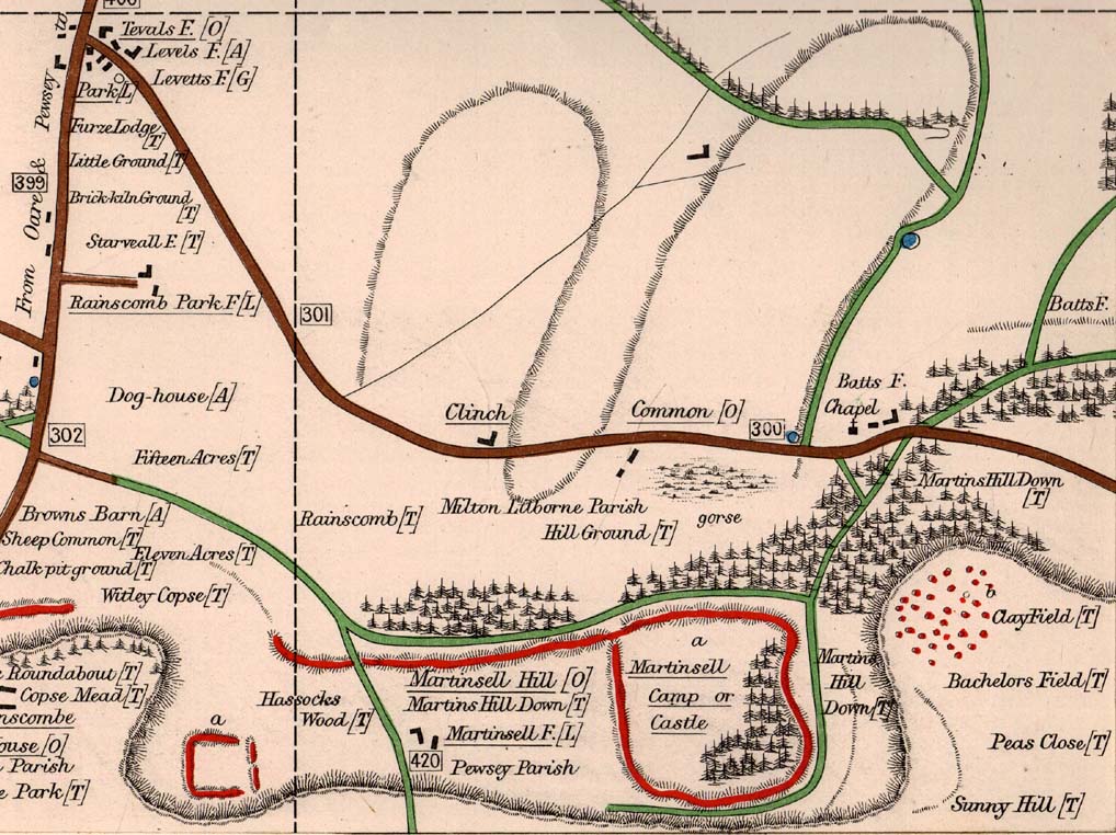
The hillfort and its remains were described in some detail in the second volume of Colt Hoare’s classic Ancient Wiltshire (1819: 107), where he wrote:
“Martin’s Hill or Martinshal Hill is in North Wilts what Long Knoll near Maiden Bradley is in South Wilts, ‘collis longe spectabilis’. This elevated point commands a most advantageous prospect of the rich vale that separates the northern and southern districts of our county, , and is rendered interesting to the antiquary by an extensive earthenwork that crowns the summit of the hill. Its form resembles an oblong square on all sides, except towards the east, where it bends inward in order to humour the natural shape of the hill. Its area, which is in tillage, comprehends thirty-one acres; and as several entrances have been made through the ramparts for the convenience of agriculture, it is difficult to ascertain on which side were the original approaches to the camp. This hill, in its formation, presents a peculiarity rather contrary to the usual system of nature, by rising in height towards the east, where a bold and tremendous precipice of smooth turf shelves down from the summit to the base of the hill. This eminence is more remarkable for the rich and extensive prospect which it affords than for the plan of its entrenchments, which consists of a single vallum and fosse. Not having discovered by digging any certain marks of ancient populations within its area, I am inclined to think that it may be considered as an asylum to which the Britons, who were very numerous in its environs, sent their families and herds in times of danger: the single vallum and ditch prove its British origin, and the great extent of its area seems to warrant this conjecture.”
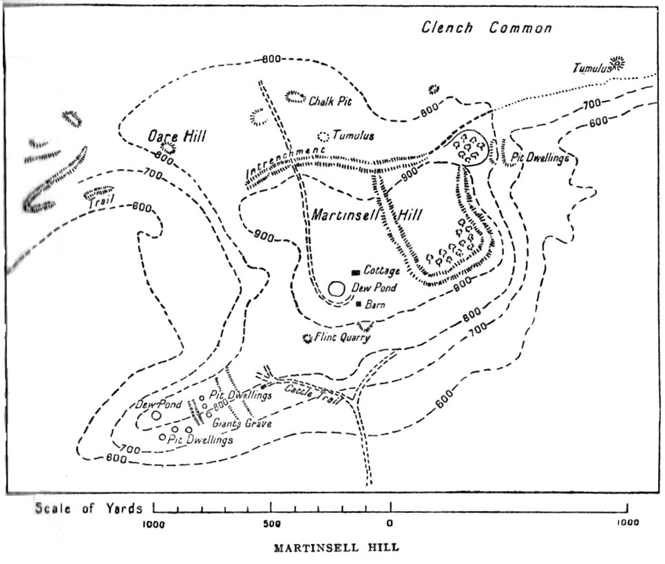
Hippisley Cox’s ground-plan
This aint a bad assumption for a fella who wrote this 200 years ago without the aid of excavation or modern archaeocentric analysis. But we can see that Hoare was utilizing that dying virtue of common sense here, and find that much of what he said remains the echoed narrative of modern archaeologists who, I believe, still aint done a detailed excavation on the site themselves. (weird for down South!) Later in the 19th century, when the reverend A.C. Smith (1885) visited and wrote about the hillfort, he added little to Hoare’s earlier words. And the descriptive narrative of the site remained roughly the same (Massingham’s intriguing ascriptions aside!) even after a small excavation was undertaken in 1907, which found very little. Hippisley Cox (1927) passed this way in his fine travelogue of ancient roads and trackways in Wessex, describing the enclosed top of this hill as
“the site of a complete neolithic settlement, including dew-ponds, a cattle compound, a flint quarry, lynchetts, dicthes of defence and deep cattle tracks formed by much going and coming of beasts from the valley.”
He may have been right! In more recent times Geoffrey Williams (1993) describes the Martinsell hillfort, which again only gives slightly more info than Colt Hoare’s 1819 narrative. The site covers 32 acres in size, is roughly rectangular in form, measuring roughly 330 yards (302m) across east to west, and 480 yards (439m) north to south. There appears to be at least one entrance on its northeastern edge.
Folklore
What seems to be a survival of prechristian sun lore is found in one or two of the events that used to happen upon and around Martinsell. A number of local history books give varying descriptions of the events here, but Devereux and Thomson (1979) condense the information nicely, telling us that
“The camp seems to have been a focus for curious Palm Sunday ‘games’ in past centuries, one of which involved a line of boys standing at intervals from the base to the summit of the hill. Using hockey sticks, they then proceeded to knock a ball in succession up the hill to the top. Another activity was the throwing of oranges down the hill slopes with boys going headlong after them. Evene more strangely, local youths used to slither down the escarpment on horses skulls.”
Mythographer and writer Michael Dames (1977) thought that such festive activities on and around the hill related to remnants of ancient goddess worship here.
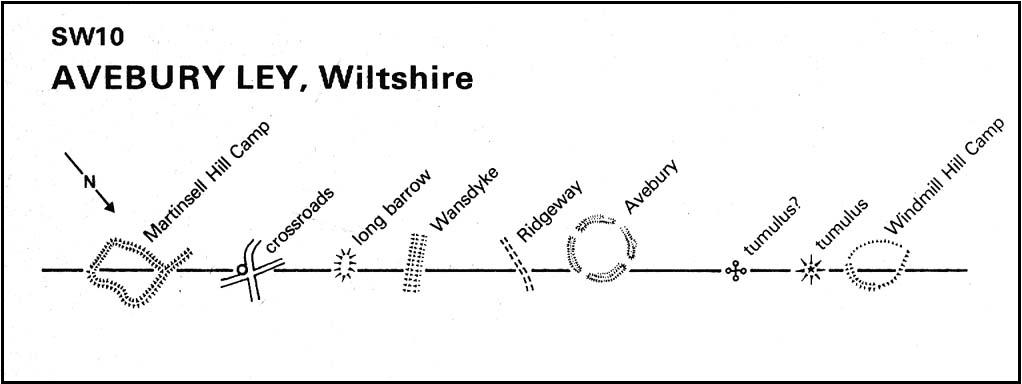
Ley line running from Martinsell (image courtesy Paul Devereux)
In Paul Devereux & Ian Thomson’s (1979) ley hunter’s guide, the Martinsell Hill site stands at the beginning of a ley, which then runs northwest for more than seven miles, eventually ending at the well known causewayed enclosure of Windmill Hill — but not before passing by the Avebury stone circle and several prehistoric tombs on route. This ley is a simple alignment between sites (as the ‘discover’ of leys, Alfred Watkins described them) and has nothing to do with the modern contrivance of energy lines.
…to be continued…
References:
Bradley, A.G., Round about Wiltshire, Methuen: London 1948.
Dames, Michael, The Avebury Cycle, Thames & Hudson: London 1977.
Devereux, Paul & Thomson, Ian, The Ley Hunter’s Companion, Thames & Hudson: London 1979.
Gomme, Alice B., “Folklore Scraps from Several Localities,” in Folklore Journal, 20:1, 1909.
Gover, J.E.B., Mawer, A. & Stenton, F.M., The Place-Names of Wiltshire, Cambridge University Press 1939.
Harding, D.W., The Iron Age in Lowland Britain, RKP: London 1974.
Hoare, Richard Colt, The Ancient History of North Wiltshire, Lackington, Hughes, Mavor & Jones: London 1819.
Massingham, H.J., Downland Man, Jonathan Cape: London 1926.
Partidge, T.B., “Wiltshire Folklore,” in Folklore Journal, 26:2, 1915.
Smith, A.C., A Guide to the British and Roman Antiquities of the North Wiltshire Downs, Wiltshire Archaeological & Natural History Society 1885.
Williams, Geoffrey, The Iron Age Hillforts of England, Horace Books 1993.