Sacred Well (destroyed): OS Grid Reference – SE 1589 3132
Archaeology & History
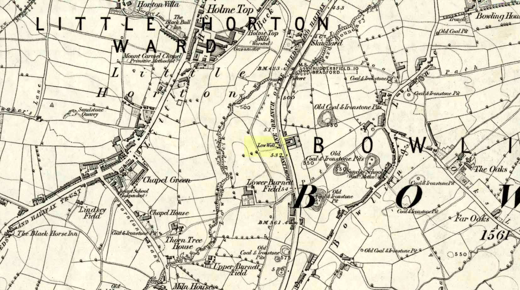
Low Well on 1852 map
Along the now-lost Low Well Road between Little Horton and West Bowling, could once be found this innocuous-sounding water source. Shown on the 1st OS-map of the area in 1852, the site was deemed to be little other than a ‘public well’. At the end of the 19th century, a small well-house was built over the waters; and the years following that saw its complete demise. Its name you would think relates to a position in the land, but the dialect word low, or lowe can mean “a flame, blaze, light, glow”, it can also refer to a prehistoric tomb. However in this case it most likely derives from “a pond or standing pool”.
…And if some of you wonder why I have given this so-called Public Well the provenance of being a “sacred well”, please keep reading…
Folklore
Although it was deemed a simple ‘public well’ by historians and the public water authority, local folk knew there was much more to it than that! In the Bradford area, this innocuously-named Well is the most promiscuously supernatural of all water sources, with a hidden history of magickians, ghosts and black dogs haunting its once ancient flow. It was a site remembered as having oracular powers, where local people used it in scrying the future. For such powers to work here, one had to gaze into the waters as they stilled at 6 o’ clock in the morning – a common time used by ritual magickians for the invocations of spirits.
The Bradford historian William Scrotum (1889) told us that in the 1860s, local people reported that the phantom black dog—or Bharguest as it was known—with its glowing red eyes, was seen coming out of the well after dark and scaring people half out of their wits. Very soon people would not even venture out after dark for fear of encountering this great harbinger of Death. Several years passed before local people called upon the abilities of a ritual magickian in the hope that he could lay the ghostly hound and bring peace and stability back to the hearts and minds of those living hereabouts. Eventually, after much work, the magickian exorcised the waters and cast the black dog back into the depths of the Earth from whence it had come and, to this day, sightings of the spectral hound have stopped.
Water sources that possess ingredients of hauntings, magic and oracular properties are universally ascribed as ‘sacred’ in one way or the other. In pre-industrial times I have little doubt that, amongst the animistic pantheon of local Bradfordians, this was no exception.
References:
Scruton, William, Pen and Pencil Pictures of Old Bradford, Thomas Brear: Bradford 1889.
Wright, Joseph, The English Dialect Dictionary – volume 3, Henry Frowde: London 1902.
There must be an easier way to visit this site than the method I used. Which was: along Cambuslang’s Main Street (A724), turn up the B759 Greenlees Road for nearly 500 yards, turning left onto Vicarlands Road. Notice the grass verge and steep slope immediately to your left. Walk into the tree-lined gorge, following the left-side along the edges of the fencing. About 150 yards down the steep glen, note the very denuded arc of stone-walling and rickety fencing on the other side of the burn. That’s it! (broken glass and an excess of people’s domestic waste are all the way down; very difficult to reach, to say the least!)
Archaeology & History
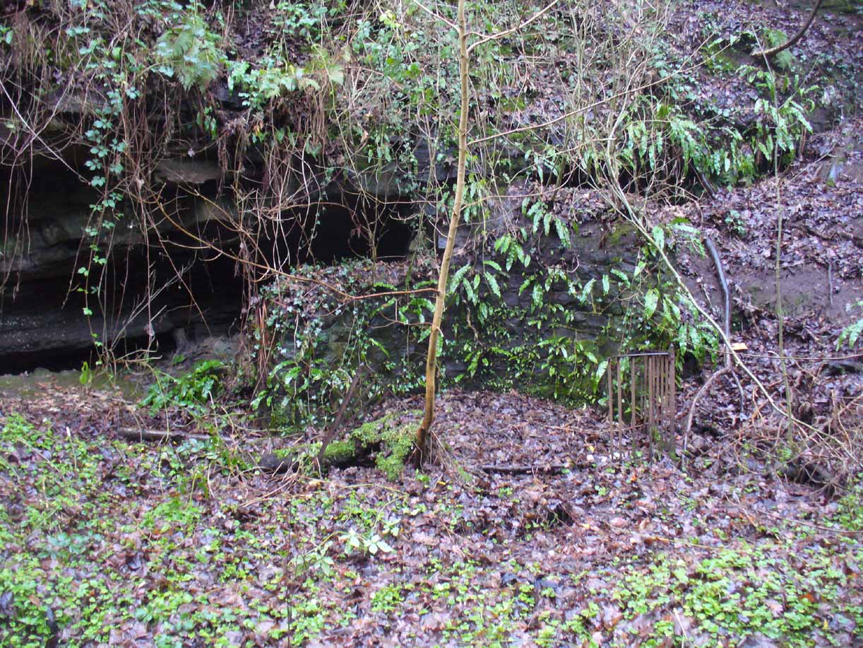
Found in a dreadful state down the once-beautiful Borgie Glen, this is one of the most curious entries relating to sacred and healing springs of water anywhere in the British Isles. Indeed, the traditions and folklore told of it seem to make the site unique, thanks to one fascinating factor…..which we’ll get to, shortly…..
Remains of the Borgie Well
The name ‘Borgie’ is an oddity. Local historians J.T.T. Brown (1884) and James Wilson (1925) wondered whether it had Gaelic, Saxon or Norse origins, with Brown thinking it may have been either a multiple of a simple bore-well, or else a title given it by a travelling minister from Borgue, in Kirkcudbright. Mr Wilson took his etymology from the very far north where “there is a stream called the Borgie” (just below the Borgie souterrain). This is said to be Nordic in origin, with
“borg, a fort or shelter, and -ie, a terminal denoting a stream. It is almost certain that our Borgie has the same origin; that is, ‘the fort or shelter by the stream.’”
The Borgie Well was described by a number of authors, each of whom spoke of its renown in the 19th century and earlier. One of my favourite Glasgow writers, Hugh MacDonald (1860), had this to say about the place:
“There are several fine springs in the glen, at which groups of girls from the village, with their water pitchers, are generally congregated, lending an additional charm to the landscape, which is altogether of the most picturesque nature. One of these springs, called “the Borgie well,” is famous for the quality of its water, which, it is jocularly said, has a deteriorating influence on the wits of those who habitually use it. Those who drink of the “Borgie,” we were informed by a gash old fellow who once helped us to a draught of it, are sure to turn “half daft,” and will never leave Cambuslang if they can help it. However this may be, we can assure such of our readers as may venture to taste it that they will find a bicker of it a treat of no ordinary kind, more especially if they have threaded the mazes of the glen, as we have been doing, under the vertical radiance of a July sun.”
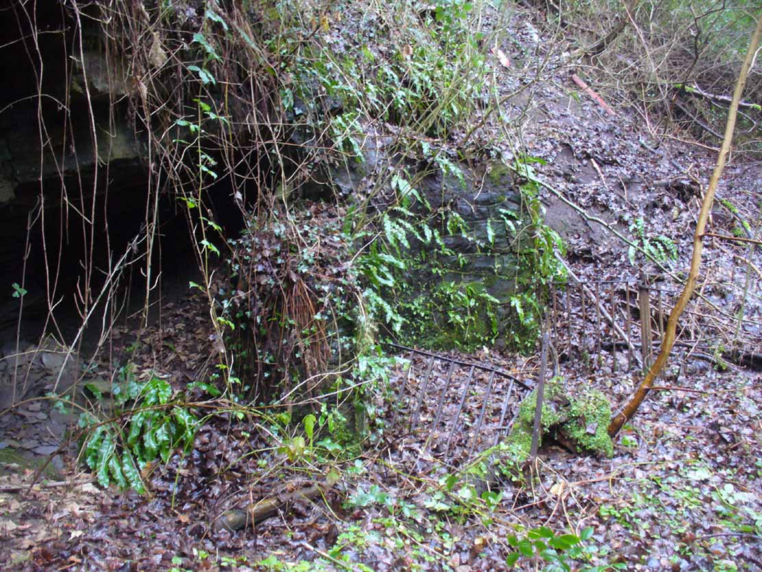
Borgie Well, looking south
It’s somewhat troublesome to reach, but a beautiful landscape indeed is where, today, only remnants of the Borgie Well exist. A very eroded semi-circle of walling and iron bars protects what was once the waters of the well—which have long since fallen back to Earth. Behind it, right behind it, overhangs the cliff and a small cave: a recess into the Earth with its very own feeling. It has the look and feel of a witch’s or hermit’s den with distinct oracular properties. This geomancy would not have gone unnoticed by our ancestors. In this enclaved silence, the once bubbling waters beneath the cliffs give a feel of ancient genius loci—a memory still there, despite modernity. Whether this crack in the Earth and its pure spring waters was some sort of Delphic Oracle in days gone by, only transpersonal ventures may retrieve… Perhaps…
In the 19th century a path took you into the glen from the north, and a commemorative plaque was erected here by a Dr Muirhead, where now lie ruins. It read:
The Borgie Well here
Ran many a year.
Then comes the main verse :_
Wells wane away,
Brief, too, man’s stay,
Our race alone abides.
A s burns purl on
With mirth or moan,
Old Ocean with its tides,
Each longest day
Join hands and say
(Here where once flowed the well)
We hold the grip
Friends don’t let slip
The Bonny Borgie Dell.
1879.
At the base was carved an appeal to the local folk:
Boys, guard this well, and guard this stone,
Because, because, both are your own.
The plaque has long since gone; and according to the local historian J.T.T. Brown (1884), the waters went with it due to local mining operations around the same time. But there was an additional rhyme sang of the Borgie Well which thankfully keeps the feel of its memory truly awake (to folk like me anyway!). It is somewhat of a puzzle to interpret. Spoken of from several centuries ago, it thankfully still prevails:
A drink 0′ the Borgie, a taste 0′ the weed,
Sets a’ the Cam’slang folks wrang in the heid.
Meaning simply, if you drink the waters of this well, you’ll get inebriated! It’s the derivation of the word ‘weed’ that is intriguing here. In Grant’s (1975) massive Scottish dialect work we are given several meanings. The most obvious is that the weed in the poem is, literally, a weed as we all know it. But it also means ‘a fever’; also ‘to cut away’ or ‘thin out’; to carry off or remove (especially by death); as well as a shroud or sheet of cloth. These meanings are found echoed, with slight variants, in the english dialect equivalent of Joseph Wright. (1905) Hugh MacDonald told that the Enchanter’s Nightshade (Circaea lutetiana) grew hereby—which, initially, one might think could account for this curious rhyme. But the Enchanter’s Nightshade has nothing to do with the psychoactive Nightshade family, well-known in the shamanistic practices of our forefathers. However, in the old pages of one Folklore Society text, William Black (1883), in repeating the curious rhyme, told us:
“The Borgie well, at Cambuslang, near Glasgow, is credited with making mad those who drink from it; according to the local rhyme —
A drink of the Borgie, a bite of the weed,
Sets a’ the Cam’slang folk wrang in the head.”
The weed is the weedy fungi.”
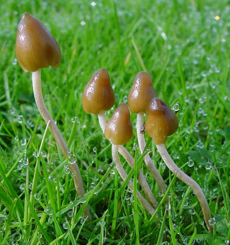
A mushroom no less! In John Bourke’s curious (1891) analysis of early mushroom use, he repeats Mr Black’s derivation. If this ‘weed’ was indeed use of mushrooms that made the local folk “go mad” or “wrang in the head” (and if not – what was it?), it’s an early literary account of magic mushroom intoxication! If this interpretation is correct, the likelihood is that the Borgie Well was a site used for ritual or social use of such intoxicants. Many sites across the world were used by indigenous people for ritual intoxication, and this could be one of the last folk remnants of such usage here. We know that Scotland has its own version of cocaine, used extensively by our ancestors (even the Romans described it) and which was still being used by working Highlanders in the 20th century—but early descriptions of mind-affecting mushrooms are rare indeed!
Psilocybe semilanceataAmanita muscaria
Mr Black gives no further folklore, nor the source of his information, other than to suggest that the madness incurred by the Well typified the people of Cambuslang! “Weedy fungi” may have been ergot (Claviceps purpurea), but the incidence of the grasses upon which it primarily grows, rye, here seems unlikely—and the folklore would certainly have included the ‘death’ aspects which that fungus brings! Fly agarics (Amanita muscaria) however, may have grown here. Old birches are close by, which produce nice quantities of those beautiful fellas. On the fields above the gorge, where now houses grow, Liberty Caps (Psilocybe semilanceata) may have profused—as they do in the field edges further out of town—but this species has no local cultural history known about from the early period. We must, however, maintain a healthy scepticism about this interpretation—but at the same time we have to take into account the ‘intoxicating’ madness which the combination of the “waters and the weed” elicited.
One final note I have to make before closing this site entry: despite the beautiful location, this small gorge is in a fucking disgraceful state. Some of the people who live in the houses above the gorge should be fucking ashamed of themselves, dumping masses of their household rubbish and tons of broken glass into the glen. If these people are Scottish, WTF are you doing polluting your own landscape like this? This almost forgotten sacred site needs renewing and maintaining as an important part of your ancient heritage. Have you no respect for your own land?!?
References:
Armitage, Paul, The Ancient and Holy Wells of Glasgow, TNA 2017.
Black, William George, Folk Medicine: A Chapter in the History of Culture, Folk-lore Society: London 1883.
Walker, J.R., ‘”Holy Wells” in Scotland”, in Proceedings of the Society of Antiquaries, Scotland, volume 17, 1883.
Wilson, James A., AHistory of Cambuslang, Jackson Wylie 1925.
Wright, Joseph, The English Dialect Dictionary – volume 6, Henry Frowde: Oxford 1905.
Acknowledgements: Huge thanks again, in various ways, to Nina Harris for getting us here; and Paul Hornby, for reminding me of my literary sources when I needed them! Thanks too to Travis Brodick and his beautiful photo of the Amanita muscaria cluster.
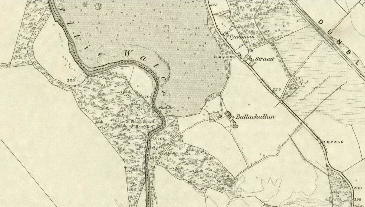
You’ll need wellies or no shoes for this excursion! From the lovely town of Callander, take the A84 road southeast out towards Doune and Stirling for a mile or so. Keep your eyes peeled for Straid by the roadside on your left and the turning right down to Ballochallan quarries. About 200 yards down, notice the industrial works on your left. Walk about 50 paces past this, then turn right into the trees. Less than 100 yards in, you’ll hit a shallow bend in the River Teith. Walk across and into the trees opposite…and if you amble just yards above the edge of the river, along the tree-line, you’ll find St. Mary’s Well…
Archaeology & History
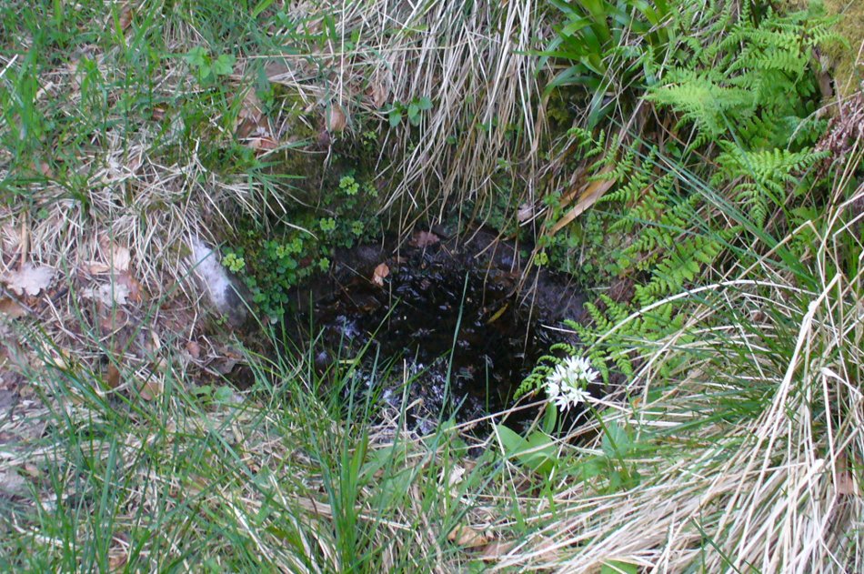
Fresh waters of the quartz-lined spring
Highlighted on the 1862 Ordnance Survey map of Callander and cited in the Object Name Book of the same year, oddly there is no mention of this mythic site in the Scottish surveys on holy wells (MacKinlay 1894; Morris 1981) — which seems rather unusual considering the importance this legendary entity (St. Mary) possessed in the christian pantheon.
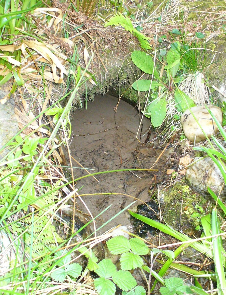
There is also some doubt about the precise position of this holy well. According to the Royal Commission account, the well “is stone lined; it measures 0.9m in diameter, and is choked with fallen leaves.” However, this appears to be the remains of a latrine (or “a bog,” as my northern tongue so eloquently exclaimed soon after finding it), now used more by frogs to lay their spawn in which their tadpoles thankfully emerge (as we found when visiting it last week). The holy well itself is about 10 yards further along the edge of the river and has a most curious architectural feature to it.
Stone-lined “well” 10 yards west of the real one
When we found the place, much of it was very overgrown indeed and it took a while to recover its status. But in doing so, we found that on all sides where the stone-lining marked the emergence of the waters, rocks large and small consisting almost entirely of quartz constituted the opening as it came out of the ground. This was a very deliberate construction feature no less! Also, the fine sandy silt which clogged up the waters were also found to have small pieces of quartz laying beneath it, seemingly as offerings that had been made here many years ago. But on the whole there seemed little evidence that the well had been used ritually for many years. So, once we’d cleaned up the debris and made the site more notable, I drank its waters and found them very fine and refreshing indeed!
In the trees behind the well you will find the overgrown remains of the old chapel, also dedicated to St. Mary. The tranquility and spirit of this place would have been truly superb. Even today, it is an ideal retreat for meditation and spiritual practice. It just seems such a curious mystery that nothing seems to be known of the place…
Folklore
The 1862 “Object Name Book” told that the waters here were renowned for having great healing properties. St. Mary’s feast day was August 15 and great were the country fairs and rituals surrounding this period across Scotland and beyond — many of which may have supplanted the more arcane festival of Lammas. However, local records are silent about any such events performed at Callander’s St. Mary’s Well. Do any old locals know more about it…?
References:
MacKinlay, James M., Folklore of Scottish Lochs and Springs, William Hodge: Glasgow 1893.
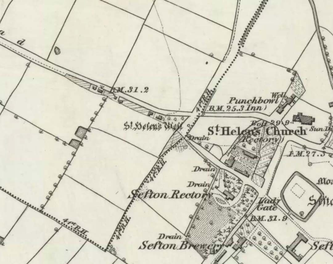
It is best to start at the Punch Bowl Inn car park, Sefton, then travel a short distance along Lunt Road by St Helen’s church. A footpath/lane is reached where a barrier stands and about 10 metres opposite the main road beneath the undergrowth is St. Helen’s holy well, or what remains of it.
Archaeology & History
St Helen’s Well on 1850 map
The well is now, sadly, capped off with an inscribed stone that recalls ST HELEN’S WELL. The well originally stood inside a rather nice little wellhouse with a pyramid-shaped, overlapping roof, with railings running around it. It was renowned for its icy waters which were especially good for people suffering from rheumatism, sprains, bruising and, also nervous problems. It had a hand pump at the side of the well-house to enable people to drink the water. But all this has now gone, though the church congregation still visit the site on the saint’s feast day and are still hoping that some day the well will be restored again.
It was probably a pre-Christian spring that in the Middle Ages turned into a pilgrimage site, especially so in the 14th century when the church was built close by.
Folklore
In pre-Reformation times it was much in use, but later on and in more recent times it had become a wishing well; pins were thrown into the well by young folk. Apparently, if the pin could be seen at the bottom of the well a favourable outcome was likely with regard to good luck in a forthcoming marriage by a couple much in love.
Addenda:
To complement Ray’s entry, here are Mr Taylor’s notes from his Ancient Crosses and Holy Wells (1906), in which he wrote the following:
“This celebrated spring rises at a distance of three hundred yards in a westerly direction from Sefton Church. In the year 1891 the well was walled round, and a handsome canopy placed over it, from the designs of Mr John Douglas, at the cost of William Philip, fourth earl of Sefton. The traditions connected with this holy well are thus graphically summed up in the History of Sefton:-
“”We must not omit to mention St Helen’s Well, which springs near the first cottage in the Thornton Road, beyond the inn. Formerly a ‘pad-road’ only led from the well to the church, the Thornton Road passing through the Rectory grounds. In the Churchwarden’s accounts we find several items of expenditure incurred for the keeping in order of St Helen’s Well. Thus we read in 1758: ‘For a new Dish and Chain for S. Ellen’s Well, 2/-.’ Ashcroft [writing about the year 1819] tells us ‘that this well was once in great repute for curing rheumatism, strains, bruises and weaknesses of the nerves. It has no mineral quality, however, and he remarks that its principal virtue seems to have been its coldness.’ In different times great respect was paid to wells ’eminent for curing distempers upon the Saint’s Day whose name the well bore,’ and it was once the custom to decorate the wells of Holy Thursday with boughs of trees, garlands of flowers, etc, places in various devices, and after service in the church the parson and singers repaired to the well, where they sang psalms and prayed. The bottom of the well, which is of no great depth and very clear, may generally be strewn with pins which are dropped in by superstitious young country folks to denote to them the probability of their marriage, which is said to be near if the pin falls pointing towards the church. Pins and pebbles were often dropped into wells, and the circles formed thereby on the surface of the water (or the question whether the water was troubled at all) were used as omens by which the observers drew inferences of future events. Mr Hampson, in his Medii Ævi Kalendarium, says: ‘I have frequently seen the bottom of S. Helen’s Well, near Sefton, Lancashire, almost covered with pins, which I suppose must have been thrown in for like purposes.'”
“…Mr Gregson wrote: ‘With regard to the curious frequency of well dedication to S. Helen, I formed a theory many years ago that the S. Helen of the county of Lancaster is not unconnected with the Celtic S. Elian, who is a frequent patron saint of wells in North Wales. Do they not both draw a common ancestry from Ella, the water sprite?'”
References:
Caroe, W.D. & Gordon, E.J.A., Sefton: A Descriptive and Historical Account, Longmans Green: London 1893.
Taylor, Henry, The Ancient Crosses and Holy Wells of Lancashire, Sherratt & Hughes: Manchester 1906.