Holy Well (destroyed): OS Grid Reference – NN 9397 5770
Archaeology & History
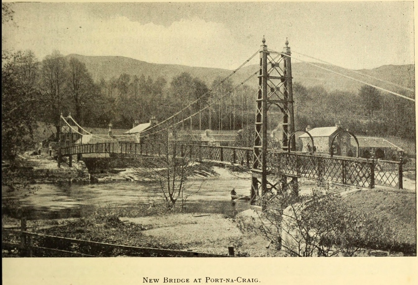
It was more than a hundred years ago that the waters of this sacred well fell back to Earth. They emerged above the eastern side of the River Tummel, close to the bridge where previous there had been a local ferry at the site known as Port-na-Craig. The mythic history of the ferry and the holy well went hand-in-hand, according to local tradition. Its lore was was spelled out by the local author and historian Hugh Mitchell in a speech he gave when a new bridge was opened here in 1913. He said:
The Well was on the far side of the bridge
“The ferry at Port-na-Craig, though not as old as many ferries in Scotland, bears the respectable antiquity of something like eight hundred years. It was established by the monks of Coupar Angus when they got a gift of the lands of Fonab, and as Coupar Angus lay on the north side of the river Tummel, they established the ferry in order to have communication. In those days the ferry boat was made of skins stretched on branches or twigs, so it was somewhat dangerous to cross in, and the monks thought that they would improve the occasion by dedicating the well near the old ferry to St. Bride, so that people, when they ventured across the ferry, might propitiate the saint. It was customary for people to drop either a small coin or a brass pin into the well. He was afraid that brass pins rather prevailed, and no doubt, St. Bride, being a lady, would find them more useful. The well remained until recent times, when it had, unfortunately, to be filled up, on account of being contaminated by neighbouring fields.”
For “fields”, read sewage—for that was the actual reason it was closed. Mr Mitchell (1923) told as much in his subsequent history of Pitlochry, saying that “sewage was percolating into it.” John Dixon (1925) echoed the same thing a few years later.
The curative and magickal properties of St Bride’s Well had considerable renown for local people. Mitchell told that:
“It had a great reputation at one time for cases of lung disease… Pins and coins were dropped into the well as votive offerings, and the bushes above it were hung with rags to call the attention of the saint to the sufferer.”
A few miles north from here, at the back of Blair Castle, an old church is dedicated to St. Bride, whose celebration date is February 1. “The day was known as Candlemas in the Highlands,” wrote Mrs Banks, saying, in commemoration of the Celtic Brigit, “Feill Bride, the festival of Bride, displaced the festival of Mary.”
References:
Dixon, John H., Pitlochry, Past and Present, L. Mackay: Pitlochry 1925.
MacKay, L., Atholl Illustrated, L. MacKay: Pitlochry 1912.
Mitchell, Hugh, Pitlochry District: Its Topography, Archaeology and History, L. Mackay: Pitlochry 1923.
Holy Well (destroyed): OS Grid Reference – NT 3190 3339
Also Known as:
St Bryde’s Well
Archaeology & History
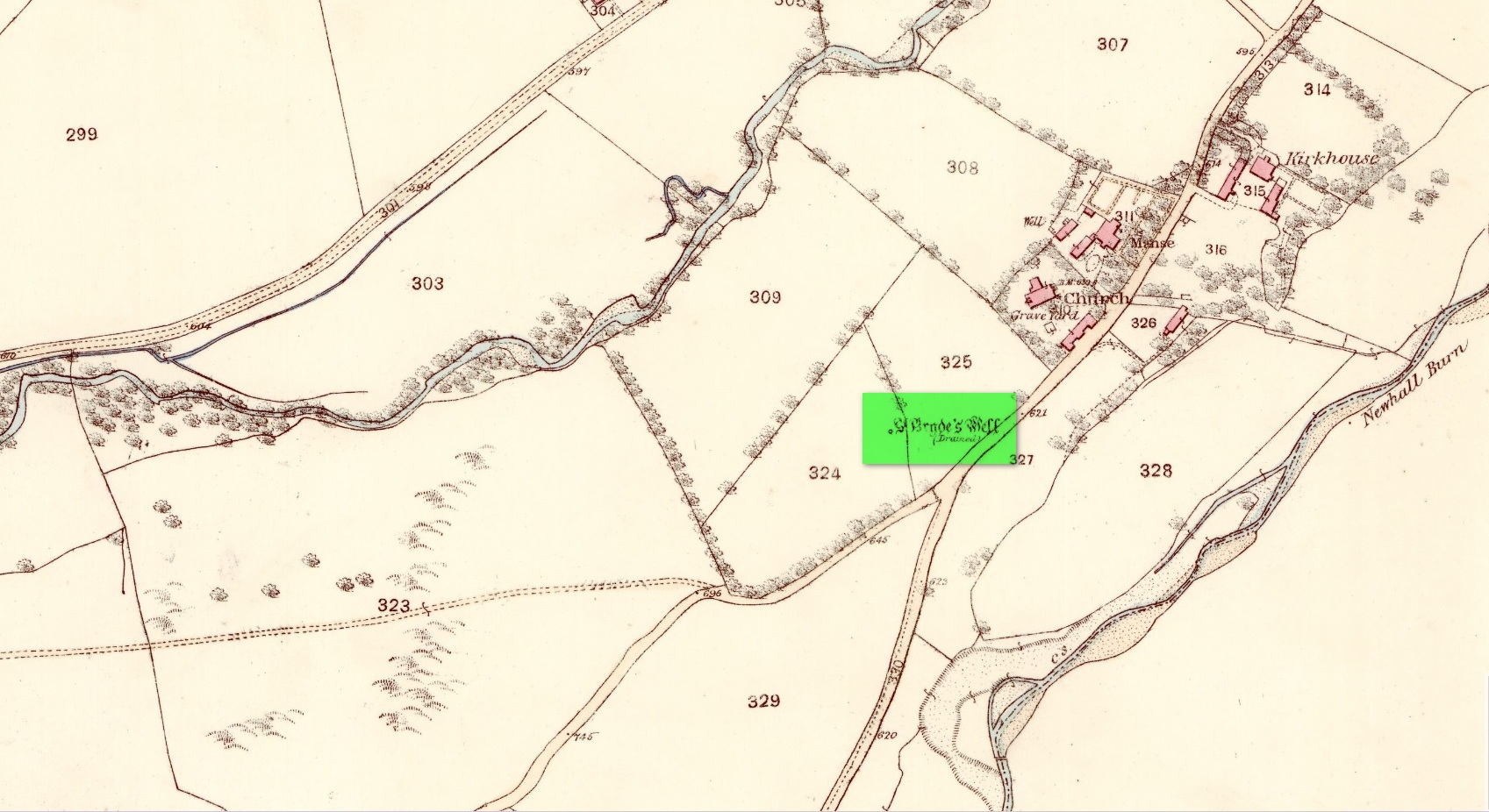
Site shown on 1858 map
Two hundred years ago, located halfway between Traquair’s present parish church and that of the demolished (apparently) 12th century church of St. Bride to the southwest, were the flowing waters of this once sacred water source. But it’s long since been destroyed. It was drained sometime prior to when the Ordnance Survey lads came here in 1856 and its water taken to supply the nearby manse. Subsequent surveys by the Royal Commission (1967) and Mr & Mrs Morris (1982) affirmed its demise. It was listed in the early Scottish holy well surveys, without comment, and I can find no local history accounts of the place.
References:
Hallen, A.W. Cornelius, “Holy Wells in Scotland,” in The Scottish Antiquary, volume 9, 1895.
Royal Commission on the Ancient & Historical Monuments, Scotland, Peeblesshire – volume 2, Aberdeen University Press 1967.
Walker, J. Russel, “‘Holy Wells’ in Scotland,” in Proceedings of the Society of Antiquaries of Scotland, volume 17,, 1883.
Acknowledgements:Huge thanks for use of the Ordnance Survey map in this site profile, reproduced with the kind permission of the National Library of Scotland.
The earliest OS-map of this area shows this well a hundred yards or so northwest of an old church and just a few yards east of the stream that is now in woodland; but unlike today, when the early survey was done there were no trees, enabling a clear view of the waters. When Myles Ronan (1927) wrote of the place, he told that it was still visible. The site was added to the Grogan & Kilfeather (1997) county inventory where they suggested it’s probable relationship with the legendary St Brigid. This seems highly probable. Does anyone know if the Well is still there?
References:
Grogan, Eion & Kilfeather, Annaba, Archaeological Inventory of County Wicklow, Stationery Office: Dublin 1997.
Ronan, Myles V., “The Ancient Churches of the Deanery of Arklow”, in Journal Royal Society Antiquaries, Ireland, December 1927.
Holy Well (destroyed): OS Grid Reference – NS 6983 4138
Archaeology & History
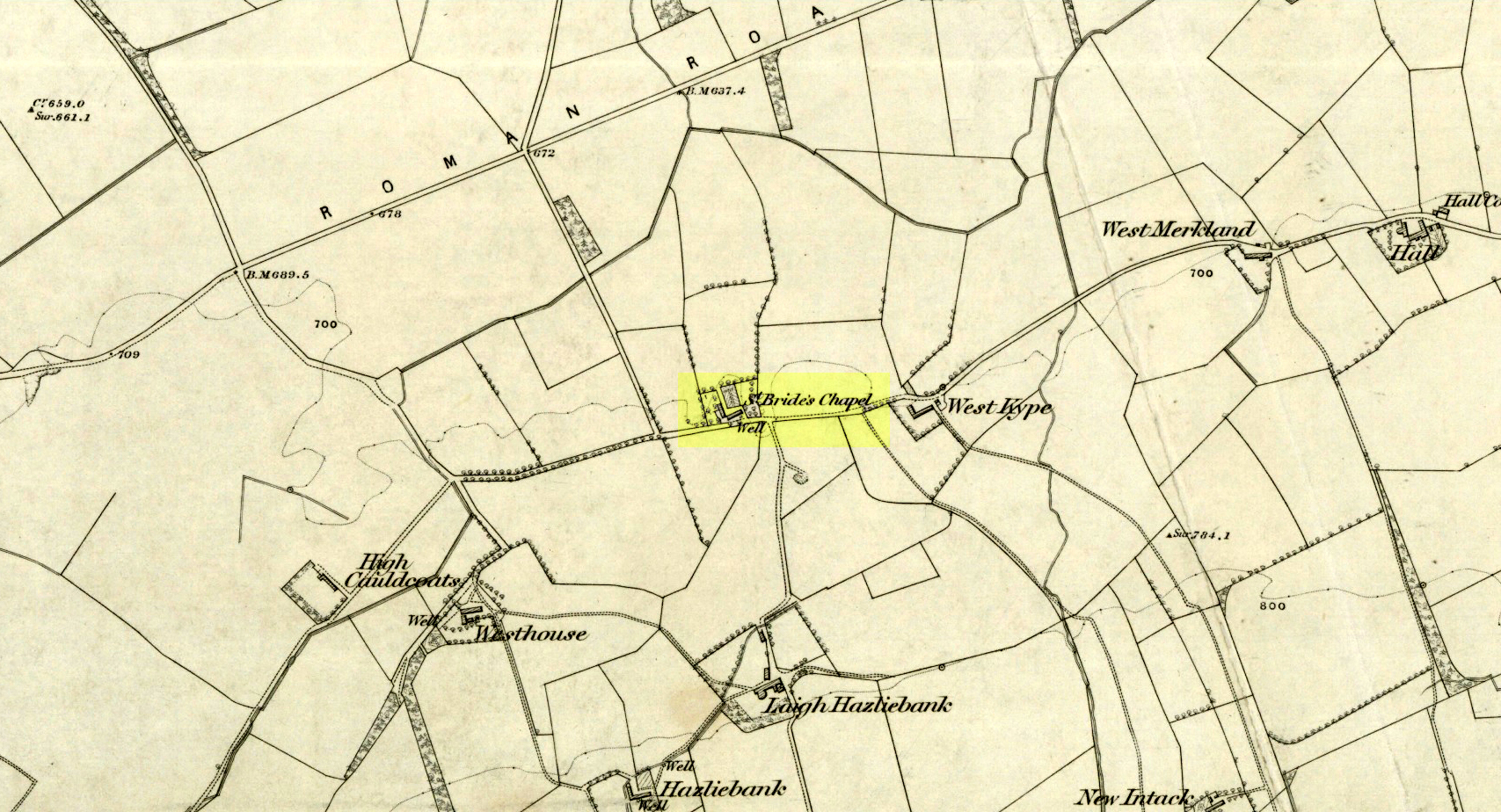
St Brides Chapel & Well on the 1864 OS-map
Shown on the 1864 OS map of the area as a ‘Well’ just at the front of St Bride’s Chapel—now a very pleasant old cottage—peasants and pilgrims would stop for both refreshment and ritual here as they walked down High Kype Road. Although the chapel was described in church records of January 1542 as being on the lands of Little Kype, close to the settlement of St Bride, there seems to be very little known about the history or traditions of the well. If anyone has further information on this site, please let us know.
Folklore
Bride or Brigit has her origins in early British myth and legend, primarily from Scotland and Ireland. Her saint’s day is February 1, or the heathen Imbolc (also known as Candlemas). Although in christian lore St. Bride was born around 450 AD in Ireland and her father a Prince of Ulster, legend tells that her step-father (more probably a teacher) was a druid and her ‘saintly’ abilities as they were later described are simply attributes from this shamanic pantheon. Legends—christian and otherwise—describe Her as the friend of animals; possessor of a magickal cloak; a magickian and a healer; and whose ‘spirit’ or genius loci became attached to ‘sacred sites’ in the natural world, not the christian renunciation of it. St Bride was one of the primal faces of the great prima Mater known as the Cailleach: the greater Gaelic deity of Earth’s natural cycles, whose changing seasons would also alter Her names, faces and clothes, as Her body moved annually through the rhythms of the year. Bride was (and is) ostensibly an ecological deity, with humans intrinsically a part of such a model, not a part from it, in contrast to the flawed judaeo-christian theology.
References:
Paul, J.B. & Thomson, J.M., Registrum Magni Sigilli Regum Scotorum: The Register of the Great Seal of Scotland AD 1513 – 1546, HMGRH: Edinburgh 1883.
This long lost ‘holy well of St Brigit’ (Tobar Bhride) has been mentioned—purely in literary repetition—by such folklore giants as F.M. MacNeill and others, but none of them give any additional information about it than that first mentioned by Alexander Stewart’s (1890) in his fascinating article on magical stones. Indeed, knowledge of this well’s very existence was only preserved thanks to a ritual incantation that was recited to imbue and maintain healing properties of one such magickal stone, known as the Charm Stone of Keppoch. It
“was an oval of rock crystal, about the size of a small egg, fixed in a bird’s claw of silver, and with a silver chain attached, by which it was suspended when about to be dipped.”
It was dipped in water taken from the sacred well of St Brigit, somewhere not far from Keppoch. The incantation made over the stone was in Gaelic, obviously, but the english translation is:
“Let me dip thee in the water,
Thou yellow, beautiful gem of Power!
In water of purest wave,
Which (saint) Bridget didn’t permit to be contaminated.
In the name of the Apostles twelve,
In the name of Mary, virgin of virtues,
And in the name of the high trinity
And all the shining angels,
A blessing on the gem,
A blessing on the water, and
A healing of bodily ailments to each suffering creature.”
On the east side of the river, just a few hundred yards away, could once be found the Fuaran na Ban-Tighearna, or the Well of Her Ladyship. In this sense, the term ‘ladyship’ refers to the “wife of a baronet or knight.” (Dwelly 1918) The idea that it may refer to Bride in Her guise as a ‘lady’ is linguistically improbable here (though not impossible). Also, if this fuaran did have a geomythic relationship with Bride, we would expect to find a Cailleach in the nearby landscape, which we don’t.
Folklore
An interesting piece of folklore that may relate to this well is described by the great Scottish landscape wanderer, Seton Gordon. (1948) Although he makes no mention of a Bride’s Well, there is the tale of a missing bride up Glen Roy, of which Keppoch sits below. “It was in earlier times,” he wrote,
“that the Maid of Keppoch was taken by the fairies in Glen Roy. She was an Irish girl, little more than a child, and had become the wife of MacDonell of Keppoch. But the wedding rejoicings were scarcely over when the bride, wandering into the oak woods which still clothe the lower slopes of Glen Roy, disappeared mysteriously. It was believed that, like the Rev Robert Kirk…she had been spirited away by the fairies. If indeed she was abducted by the Little People they held her closely, for from that day to this no trace has been found of the fair Maid of Keppoch.”
St Bride of course was Irish, like the Maid of Keppoch. And just a mile up Glen Roy from Keppoch House we find the Sron Dubh and Sithean, or Ridge of the Dark Fairy Folk. There are several burns (streams) running either side and below this fairy haunt, but I can find none with Bride’s name. Someone, somewhere, must know where it is…
References:
Gordon, Seton, Highways and Byways in the Central Highlands, MacMillan: London 1948.
Dwelly, Edward, The Illustrated Gaelic English Dictionary – volume 1, Fleet Hants 1918.
Stewart, Alexander, “Notice of a Highland Charm-Stone,” in Proceedings Society Antiquaries, Scotland, volume 24, 1890.
Holy Well (covered): OS Grid Reference – TQ 3157 8111
Archaeology & History
St Brides Well on 1896 map
Close to the centre of that corporate money-laundering place of homo-profanus that is the City of London, was once a site that represents the antithesis of what it has become. Tacked onto the southeastern side of St. Bride’s church along the appropriately-named Bride Lane, the historian Michael Harrison (1971) thought the Holy Well here had Roman origins. It “was almost certainly,” he thought,
“in Roman times, the horrea Braduales, named after the man who probably ordered their construction: Marcus Appius Bradua, Legate of Britain under Hadrian, and the British Governer in whose term of office the total walling of London was, in all likelihood, begun.”
This ‘Roman marketplace of Bradua’ that Harrison describes isn’t the general idea of the place though. Prior to the church being built, in the times of King John and Henry III, the sovereigns of England were lodged at the Bridewell Palace, as it was known. Mentioned in John Stow’s (1720) Survey of London, he told:
“This house of St. Bride’s of later time, being left, and not used by the Kings, fell to ruin… and only a fayre well remained here.”
The palace was eventually usurped by the building of St. Bride’s church. The most detailed account we have of St. Bride’s Well is Alfred Foord’s (1910) magnum opus on London’s water supplies. He told:
“The well was near the church dedicated to St. Bridget (of which Bride is a corruption; a Scottish or Irish saint who flourished in the 6th century), and was one of the holy wells or springs so numerous in London, the waters of which were supposed to possess peculiar virtues if taken at particular times. Whether the Well of St. Bride was so called after the church, or whether, being already there, it gave its name to it, is uncertain, more especially as the date of the erection of the first church of St. Bride is not known and no mention of it has been discovered prior to the year 1222. The position of the ancient well is said to have been identical with that of the pump in a niche in the eastern wall of the churchyard overhanging Bride Lane. William Hone, in his Every-Day Book for 1831, thus relates how the well became exhausted: ‘The last public use of the water of St. Bride’s well drained it so much that the inhabitants of the parish could not get their usual supply. This exhaustion was caused by a sudden demand on the occasion of King George IV being crowned at Westminster in July 1821. Mr Walker, of the hotel No.10 Bridge Street, Blackfriars, engaged a number of men in filling thousands of bottles with the sanctified fluid from the cast-iron pump over St. Bride’s Well, in Bride Lane.” Beyond this there is little else to tell about the well itself, but the spot is hallowed by the poet Milton, who, as his nephew, Edward Philips records, lodged in the churchyard on his return from Italy, about August 1640, “at the house of one Russel a taylor.”
In Mr Sunderland’s (1915) survey, he reported that “the spring had a sweet flavour.”
Sadly the waters here have long since been covered over. A pity… We know how allergic the city-minds of officials in London are to Nature (especially fresh water springs), but it would be good if they could restore this sacred water site and bring it back to life.
Folklore
Bride or Brigit has her origins in early British myth and legend, primarily from Scotland and Ireland. Her saint’s day is February 1, or the heathen Imbolc (also known as Candlemas). Although in christian lore St. Bride was born around 450 AD in Ireland and her father a Prince of Ulster, legend tells that her step-father (more probably a teacher) was a druid and her ‘saintly’ abilities as they were later described are simply attributes from this shamanic pantheon. Legends—christian and otherwise—describe Her as the friend of animals; possessor of a magickal cloak; a magickian and a healer; and whose ‘spirit’ or genius loci became attached to ‘sacred sites’ in the natural world, not the christian renunciation of it. St Bride was one of the primal faces of the great prima Materknown as the Cailleach: the Gaelic deity of Earth’s natural cycles, whose changing seasons would also alter her names, faces and clothes, as Her body moved annually through the rhythms of the year. Bride was (and is) ostensibly an ecological deity, with humans intrinsically a part of such a model, not a part from it, in contrast to the flawed judaeo-christian theology.
References:
Foord, Alfred Stanley, Springs, Streams and Spas of London: History and Association, T. Fisher Unwin: London 1910.
Gregory, Lady, A Book of Saints and Wonders, Colin Smythe: Gerrards Cross 1971.
Harrison, Michael, The London that was Rome, Allen & Unwin: London 1971.
McNeill, F. Marian, The Silver Bough – volume 2, William MacLellan: Glasgow 1959.
Follow the same directions to find the Blackheath Circle, but instead of turning onto the golf course, keep going up the steep road until you reach the T-junction at the top; then turn left and go along the road for about 200 yards, past the second track on the left, keeping your eyes peeled across the small moorland to your left where you can see the rocks rising up. Walk along the footpath towards them. You can’t really miss the place!
Archaeology & History
The Bride at sunset – the fallen Groom to her left
If you’re a heathen or geologist and you aint seen this place, check it out – you won’t be disappointed! First mentioned in 1491, this has always been a place of some repute. Its legendary companion, the ‘Groom’, lays resting on the Earth after being felled sometime in the 17th century.
F.A. Leyland’s 1860s drawing
A beautiful, remarkable and powerful site of obvious veneration. First described in local deeds as early as 1491, there are a great number of severely weathered boulders all round here, many like frozen rock giants haunting a magickal landscape. The modern lore ascribes the stones to be dedicated to Bride, goddess of the Brigantian people. And like Her legendary triple-aspect, we find here in the landscape a triple aspect to the outcrops themselves: to the west are the Bride Stones; to the east, the Little Bride Stones; with the Great Bride Stones as the central group, surveying everything around here.
At the main complex is what is singularly known as the Bride itself: a great smooth upright pillar of stone fourteen feet tall and nine feet wide at the top, yet only about two feet wide near its base, seemingly defying natural law. Watson (1775) described, next to the Bride herself, “stood another large stone, called the Groom…(which) has been thrown down by the country people” – probably under order of the Church. Crossland (1902) told how the Bride also acquired the title, “T’ Bottle Neck,” because of the stone’s simulacrum of an upturned bottle.
The Bride & her Groom (laid on the earth)The ‘head’ or top of the Bride Stone
Scattered across the tops of the many rocks hereby are many “druid basins” as Harland and Wilkinson (1882) described them. Many of these are simply basins eroded over the millenia by the natural elements of wind and rain. It is possible that some of these basins were carved out by human hands, but it’s nigh on impossible to say for sure those that were and those that were not. If we could find a ring around at least one of them, it would help — but in all our searches all round here, we’ve yet to locate one complete cup-and-ring. So we must remain sceptical.
On the mundane etymological side of things, the excellent tract by F.A. Leyland (c.1867) suggested the Bride Stones actually had nothing to do with any goddess or heathenism, but derived simply from,
“the Anglo-Saxon adjective Βñáð, signifying broad, large, vast — hence the name of the three groups known as the Bride Stones. The name of The Groom, conferred on the prostrate remains, appears to have been suggested by the fanciful definition of the Saxon Brád, as given by (Watson).”
However, the modern place-name authority A.H. Smith (1963:3:174) says very simply that the name derives from “bryd, a bride.”
A “rude stone” was described in one tract as being a short distance below this great rock outcrop; it was turned into a cross by the local christian fanatics and moved a few hundred yards west, to a site that is now shown on modern OS-maps as the Mount Cross.
Folklore
Although local history records are silent over the ritual nature of these outcrops, tradition and folklore cited by the antiquarian Reverend John Watson (1775) tell them as a place of pagan worship. People were said to have married here, although whether such lore evolved from a misrepresentation of the title, Bride, is unsure. In the present day though there have been a number of people who have married here in recent years.
If the Brigantian goddess was venerated here, the date of the most active festivities would have been February 1-2, or Old Wives Feast day as it was known in the north. The modern witches Janet and Stewart Farrar, who wrote extensively about this deity (1987), said of Bride: “one is really speaking of the primordial Celtic Great Mother Herself,” i.e., the Earth Mother.
Telling of further lore, Watson said that weddings performed here in ages past stuck to an age-old tradition:
“during the ceremony, the groom stood by one of these pillars, and the bride by the other, the priests having their stations by the adjoining stones, the largest perhaps being appropriated to the arch-druid.”
New Age author Monica Sjoo felt the place “to have a special and uncanny power.” This almost understates the place: it is truly primal and possesses the virtues of strength, energy, birth and solace.
References:
Bennett, Paul, The Old Stones of Elmet, Capall Bann: Milverton 2001.
Crossland, Charles, “Place-Names in the Parish of Halifax in Relation to Surrounding Natural Features,” in Halifax Naturalist, volume 7, 1902.
Farrar, Janet & Stewart, The Witches’ Goddess, Hale: London 1987.
Harland, John & Wilkinson, T.T., Lancashire Folklore, John Heywood: Manchester 1882.
Leyland, F.A., The History and Antiquities of the Parish of Halifax, by the Reverend John Watson, M.A., R.Leyland: Halifax n.d. (c.1867).
Smith, A.H., The Place-Names of the West Riding of Yorkshire – volume 3, Cambridge University Press 1963.
Watson, John, The History and Antiquities of the Parish of Halifax, T. Lowndes: London 1775.
From the tourist-infested (but lovely) town of Callander, look west to the largest of the nearby mountains — that’s where you’re heading! You can keep along the A84 road out of the town for 4-5 miles (past the Falls and Pass of Leny) till you reach the parking spot on your left. Cross the river and go up into the signposted woodland. Keep walking up thru the trees until the rocky mass emerges above you. You can either keep to the path and follow the long walk round the mountain, or go straight up the crags above you. The top’s in sight!
Folklore
Getting up here is no easy task if you’re unfit — but it’s well worth the effort for the journey alone! And in bygone centuries it seems, local people made it a particular pilgrimage at specific times during the year. Even the name of this great hill has some supposed affinity with holy issues; though some modern english etymologists put a dampener on such things. In Charles Rogers’ (1853) excellent Victorian exposition, he told that,
“Benledi is an abbreviation of the Celtic Ben-le-dia, signifying the hill of God.”
But whether the old heathens who named most of these ancient mountains would echo his oft-repeated derivation is another thing altogether! However, there are other decidedly pre-christian events that used to be enacted here, for the summit of Ben Ledi was, tradition tells, where the sun god was worshipped. It would seem, however, that this tradition is a somewhat watered-down version of it as a site of cosmological and social renewal. (see Eliade 1974) For akin to the annual pilgrimage that happens upon Croagh Patrick in County Mayo, Ireland, here upon Ben Ledi,
“For three days and three nights…the inhabitants of the district in those primitive times convened, at the period of summer solstice, on the summit of the mountain, to join in the rites of heathen worship.”
More recent lore tells the date of such sacred gatherings was Beltane. Also a short distance to the north of the summit of Ben Ledi is a small loch known as Lochan-nan-corp. Mr Rogers again tells us that,
“Here two hundred persons, who were accompanying a funeral from Glenfinglas to the churchyard of St. Bride, suddenly perished; the ground had been covered with snow and the company were crossing the lake on the ice, when it at once gave way.”
It seems a most unusual event. But the tale itself implies that a corpse route passed by the way of this high summit, down to the heathen chapel of St. Bride at the bottom of its eastern face: a huge undertaking in itself with probably archaic origins. Does anyone know owt more about this?
References:
Eliade, Mircea, The Myth of the Eternal Return, Princeton University Press 1974.
Eliade, Mircea, Patterns in Comparative Religion, Sheed & Ward: London 1958.
Roger, Charles, A Week at Bridge of Allan, Adam & Charles Black: Edinburgh 1853.
From Otley go north straight over the river and upwards into the countryside for nearly two miles (past the TV mast on the right). As you reach near the top of the hill, there’s a turn to your right. Go on here for a hundred yards or so, then walk along the footpath to your right. After a few hundred yards, keep your eyes out for the stone just through the gate, in the walling on your left.
Archaeology & History
Although we see named on the 1853 Ordnance Survey map the respective place-names of Bride Cross House and Bride Cross Allotment, the first literary reference to any site here as a standing stone appears to be Eric Cowling (1946) who, when commenting on the pagan tradition and folklore of ancient sites, told that
“The name of Bride Cross Farm, Dob Park, is very significant, for at the meeting place of several tracks to the south-east is a squat standing stone built into a wall and marked as a boundary stone, which was probably Brides Cross.”
Bride Stone, Farnley MoorBoundary markers on top
Although I’d read about this place as a kid, it was Graeme Chappell who first brought me here some twenty years back, in one of our many exploratory forays into the prehistory of this area. It’s a nice fat squat standing stone, similar in stature to the more famous Bull Stone near Otley Chevin, a few miles to the south — though our Bride Stone here is about half as high. Only about three-feet tall, it stands by the gate at the wall-side about 200 yards down the footpath from the Dob Park Lodge road and does seems to have been used as a boundary marker, as the letters “F.F.” are carved deeply on top of the upright (possibly denoting the Fawkes family of Farnley).
Cowling’s assertion that this old stone accounts for the ‘Bride Cross’ place-name is probably right, as the site is roughly midway between the respective place-names of the House and Allotment. There is an old field-name of Crosse Close in the vicinity, from 1692, but I haven’t located it. If such a cross ever existed nearby (most likely, it’s gotta be said), it’s obviously the relic which left the place-names — though the standing stone was certainly here first! As yet, we’ve found no references to this place before 1853…which can’t be right…
Folklore
Seems to be a petrification legend in here somewhere. Although the short tale doesn’t say as much, it is supposed to have got its name through “the murder of a bride, rejected by a suitor, on her return from a wedding.” Indeed, I’d go so far as to say ‘fertility’ as well!
Eric Cowling (1946) really stuck his neck out and reckoned sacrifices occurred here in the not too distant past. This may relate to the nearby Haddock Stones, a few hundred yards south, thought to derive its name from a cairn and ‘altar stones.’
References:
Bennett, Paul, The Old Stones of Elmet, Capall Bann: Milverton 2001.
Cowling, E.T., Rombald’s Way, William Walker: Otley 1946.
Phillips, Guy Ragland, Brigantia — A Mysteriography, RKP: London 1976.
Smith, A.H., The Place-Names of the West Riding of Yorkshire – volume 5, Cambridge University Press 1961.