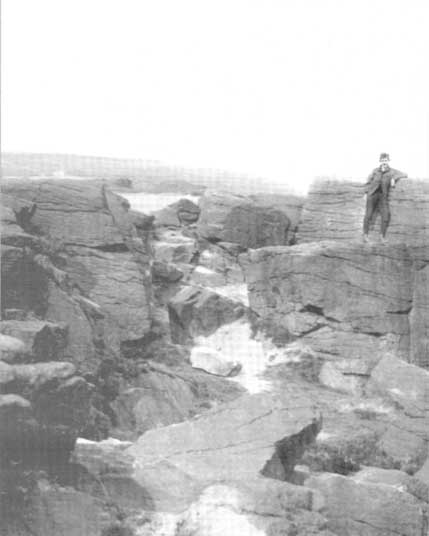
The exact location of this site seems privy to a select few and has remained that way since its existence appeared in print in the 19th century. It was first mentioned by Arthur Mitchell (1874) following a holiday that he’d had in the area in the early 1870s. He’d visited a petroglyph at Laggan with a Mr David Ross and when he returned home received a letter from him that told how,
“he had heard from Mr M’Bain of Auchterblair of two huge granite boulders, situated on a shelving rock over an abyss on the Loch Avon side of Cairngorm, with hand-made cups on them about a foot wide and correspondingly deep.”
They were subsequently visited by Thomas Wise (1884) a few years later, who told how these huge granite boulders were,
“20 feet in height,” upon which “there are four basins, 1 foot, or 1 foot and a-half long, and 6 inches wide at the top, rounding off to 1 inch in the bottom.”
Initially Mr Mitchell (1874) was cautious in associating these carved basins with cup-marked stones—and indeed, we concur with this—but seemed to have changed his opinion when he wrote about them a few years later (Mitchell 1881). But it’s the folklore attached to this site that intrigued him – and myself…
Folklore
The traditions attached to this site will be recognised by all students of animism and folklore. Arthur Mitchell (1874) was informed how the carved bowls in the stone helped infertile women and how “sitting on (them) is said to be efficacious in cases of barrenness.” Their importance was highlighted in the fact that there had been “pilgrimages to them undertaken within the memory of people still living.”
This was affirmed by Thomas Wise (1884) who told that,
“They are supposed to be efficacious in barrenness, and people still living remember pilgrims coming to sit upon them for some time, that they might obtain what they wished. A visit to them was by no means an easy task, as the ascent was difficult, and to sit on them required a steady head, as they are on the brink of a rock overhanging a precipice. These basins are the “woman’s stone” mentioned by Tennant. They are supposed to be the resting place or throne of a certain fairy queen; but however efficacious they may have been, they have lost much of their celebrity; and as the shepherd, who acted as guide to the pilgrims, is dead, and has left no successor, they are now rarely visited.”
Does anyone know the whereabouts of this heathen magickal site? If you happen to find it, see if you can get a good photo or two and let us know on our Facebook group.
From the lovely village of Summerbridge (near Pateley Bridge), go up the steep Hartwith Bank road, going straight across at the crossroads for another few hundred yards, passing the old tombs of Graffa Plain on your right…and they’ll start appearing on your left-hand side (west). Do not go into the expensive National Trust car-park. Instead (if you’ve already gone too far), about 100 yards before the Car Park you’ll find a small dirt-track on your left a short distance away. But if you drive past the rip-off car park, another 100 yards on there’s another spot where you can easily park up on the right-hand side of the road. Then cross the road and follow y’ nose…
Archaeology & History
The OS grid reference given above is an approximation — for obvious reasons. This is a huge area that’s covered by Britain’s finest natural megalithic features, obviously sculptured by Nature Herself — though many are the historians who sought to give Druids the credit here. God knows how! The area over which these magnificent rock sentinels live covers some 60 acres and is some 1000 feet above sea level. The view from the hill around which the encircling parade of rocks guards is excellent, allowing our eyes to catch focus on the distant lands of Whernside, Simon’s Seat, York Minster, the Cleveland Hills and Kilburn’s white horse. It’s quite a view.
Easternmost Rocking StoneIdol Stone (Godfrey Higgins 1826)
But this tends to be overlooked when you first visit the place, as the rocks which surround and walk alongside you overwhelm with impressions not encountered before. To those with spirit, you’ll be bouncing and running all day here, clambering upon rocking stones, jumping between dodgy gorges that await falls, and just aching to climb pinnacles that deny you. But then, if you need the selfishness of silence, this arena will only grant such solace when the rains are about, or dense fog and low cloud keeps others from this haunting amphitheatre. And it’s not surprising… The mass of rocks contort into the most beautiful and curious simulacra, which would not have gone unnoticed, nor deemed unimportant in the sacred landscape of our ancestors…
Brimham Rocks have been written about since the 17th century, though they didn’t receive the serious attention of outsiders until the 19th, when numerous Victorian writers — from antiquarians and geologists, to archaeologists and Druids — got to hear about the place. And by the beginning of the 20th century, a veritable mass of articles had been written in journals and travelogues of all persuasions! These quiet Yorkshire Rocks had become truly famous!
Brimham Rocks (Walbran 1856)Old Woman and her consort
A lengthy essay was written in the distinguished archaeology journal of its time, Archaeologia, by northern historian Hayman Rooke (1787), who thought that some of the rocks here had been tampered with by the druids; with the legendary Cannon Rock in particular possessing oracular properties. The site as a whole was, he posited, a temple for Druids in ancient days. Certainly the place would have been deemed as sacred, whether by the druids or our more remote neolithic and Bronze Age ancestors.
Harry Speight & his mates, c.1890
In Harry Speight’s magnum opus, Nidderdale (1894), he described these rocky giants as best as he could, admitting as others before and since, that no mere words can convey the impression that only a personal encounter liberates, saying:
“The Brimham Rocks are among the greatest natural wonders of Yorkshire, and many have been the theories from time to time advanced as to the cause of their extraordinary aspects… The resemblances to natural and artificial objects are most striking. There we have the Elephant Rock, the Porpoise Head, the Dancing Bear (a very singular, naturally-shaped specimen), the Boat Rock, showing the bow and stern completely, etc. Then there is the great Idol Rock, a most mysterious-looking object, of almost incredible size and form. It is a perfectly detached block, fully twenty feet high, weathered along face joints into three roughly circular pieces, each from 40 to 50 feet in circumference, piled one above the other; the whole mass, weighing by estimation over 200 tons, being poised on a pyramid 3½ feet in diameter; the pivot itself supporting this immense column having a diameter of barely 12 inches.
“East of the guide’s house are the famous Rocking Stones, consisting of a group of four rocks, which were discovered to be movable in the year 1786. The two on the west side weighing approximately 50 and 25 tons, require but little force to vibrate, while those on the east side, though much smaller are not so well poised and do not move readily. Each of the larger stones has a basin-like cavity on the top, and a kind of knee-hole open to the north, said to be the work of Druids. Close to the Rocking Stones are the appropriately-named Oyster-shell Rock, and the Hippopotamus’ Head. Turning now some thirty yards north of the Idol Rock we ascend Mount Delectable, where is the agreeable Courting or Kissing Chair, happily at not too close quarters with the above Hippopotamus’ Head and Boar’s Snout. The Chair consists of a single seat, but why it should be so called, I had better leave the amorous lover to solve. West of these is the more sober Druid’s Reading Desk, with its church-like lectern on a stout stone base. The we come to the Lover’s Leap, a gigantic and abrupt face of beetling crag, weathered to the west, and rising to a height of 60 to 70 feet, with three immense fragments balanced in a very remarkable manner at the summit. The rock is in tow principal sections, and an iron hand-rail has been fixed across the chasm to enable visitors to look down from the top. Further south are the Frog and Tortoise Rocks, the latter presenting from one point of view a capital resemblance to a tortoise creeping up the face of the crag towards the imaged frog. A little below this is a good imitation of a cannon, projecting from the edge of the cliff. In addition to these singular resemblances there are many others which the guide points out, such as the Yoke of Oxen, Mushroom Rocks, Druid’s Oven, Dog’s Head, Telescope, and the curiously perforated Cannon Rock, etc.”
In a later work, Speight (1906) also mentioned the existence of a Druid’s Circle some 300 yards west of the main natural temples, but this site appears to have been destroyed. Thankfully the large standing stone on Hartwith Moor, a mile to the south, can still be found upright…
Folklore
Idol Stone (Hargrove 1809)
In folklore, there’s little surprise this place was held by just about every 18th and 19th century historian as a ‘druidic site.’ But more interesting – in the light of Paul Devereux’s (2001) work on acoustic archaeology – is what Edmund Bogg (c.1895) said of these huge contorted stones:
“In bygone days these immense stones were supposed to be the habitation of spirits. The echo given from the rocks was said to be the voice of the spirit who dwelt there, and which the people named the Son of the Rocks. From a conversation we had with the peasantry not far from here, it seems the ancient superstition had not yet fully disappeared.”
This is precisely the notion of spirit given to rocky places elsewhere in the world, where the very echo was perceived as the ‘voice of the rocks’. Meditate on it a bit, in situ. (a fine summary of this notion and its implications — which has crept into archaeology of late — can be found in Paul Devereux’s work, Stone Age Soundtracks)
One of Brimham’s southwestern rocks was known as the Noon Stone when Mr Rooke (1787) came here. There are many stones with this name scattering Yorkshire and other northern counties, each with the same mythic background: that the sun casts a shadow from it at midday to indicate the time of day. Of this Noon Stone Mr Hooke also told us that,
“On Midsummer Eve fires are lighted on the side. Its situation is apposite for this purpose, being on the edge of a hill, commanding an extensive view. This custom is of the most remote antiquity.”
On the very southern edge of Brimham’s Rocks (some might say beyond their real border) is the Beacon Rock — and it is aptly named: as in the year 1887 on the day of Queen Victoria’s Jubilee, a great beacon fire was lit here, signalling to others in the distance. Its title however, pre-dates Victoria’s Jubilee, though we don’t know how far back in time it goes…
…to be continued…
References:
Bogg, Edmund, From Eden Vale to the Plains of York, James Miles: Leeds c.1895.
Devereux, Paul, Stone Age Soundtracks: The Acoustic Archaeology of Ancient Sites, Vega: London 2001.
Grainge, William, The History and Topography of Harrogate and the Forest of Knaresborough, John Russell Smith: London 1871.
Harrison, William, A Descriptive Account of Brimham Rocks in the West Riding of Yorkshire, A. Johnson: Ripon 1846.
Michell, John, The Earth Spirit: Its Ways, Shrines and Mysteries, Thames & Hudson: London 1975.
Michell, John, Simulacra, Thames & Hudson: London 1979.
Rooke, Hayman, “Some Account of the Brimham Rocks in Yorkshire,” in Archaeologia journal, volume 8, 1787.
Speight, Harry, Nidderdale and the Garden of the Nidd, Elliot Stock: London 1894.
Speight, Harry, Upper Nidderdale, with the Forest of Knaresborough, Elliot Stock: London 1906.
Walbran, John Richard, A Guide to Ripon, Fountains Abbey, Harrogate, Bolton Abbey, etc, Johnson: Ripon 1856.
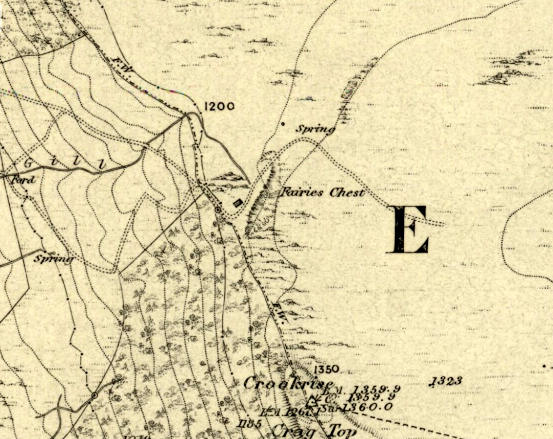
This is an awesome beast! You can either approach it from Nettlehole Ridge ‘stone circle’ as I did, or take the more sensible approach and begin from Embsay village, walking up the path towards Embsay reservoir and onto the moorland heights of Crookrise Crag, 1350 feet above sea level. Worra view! But keep walking a little more, downhill, and it’ll hit you right in the face!
Archaeology & History
Fairy’s Chest, Embsay Moor
Known as an abode of the little people in the 19th century and shown on the earliest Ordnance Survey map of the region, I know of no previous accounts of this giant elongated boulder, forty feet long and nearly the same size as our legendary Hitching Stone that’s nestled below the small cliffs. The boulder is surrounded by what seems like cairn-material on all sides (though it doesn’t look prehistoric). You’re looking straight west from here, right at the three small paps of Sharp Haw, Rough Haw and Flasby Fell. If you like huge rocky outcrops, this (and others nearby) will make your day!
Folklore
Said to have been the abode of the little people in ages gone by; though even an old chap we met on our wander here told us how the legends it once held “have died with the old folk it seems.”
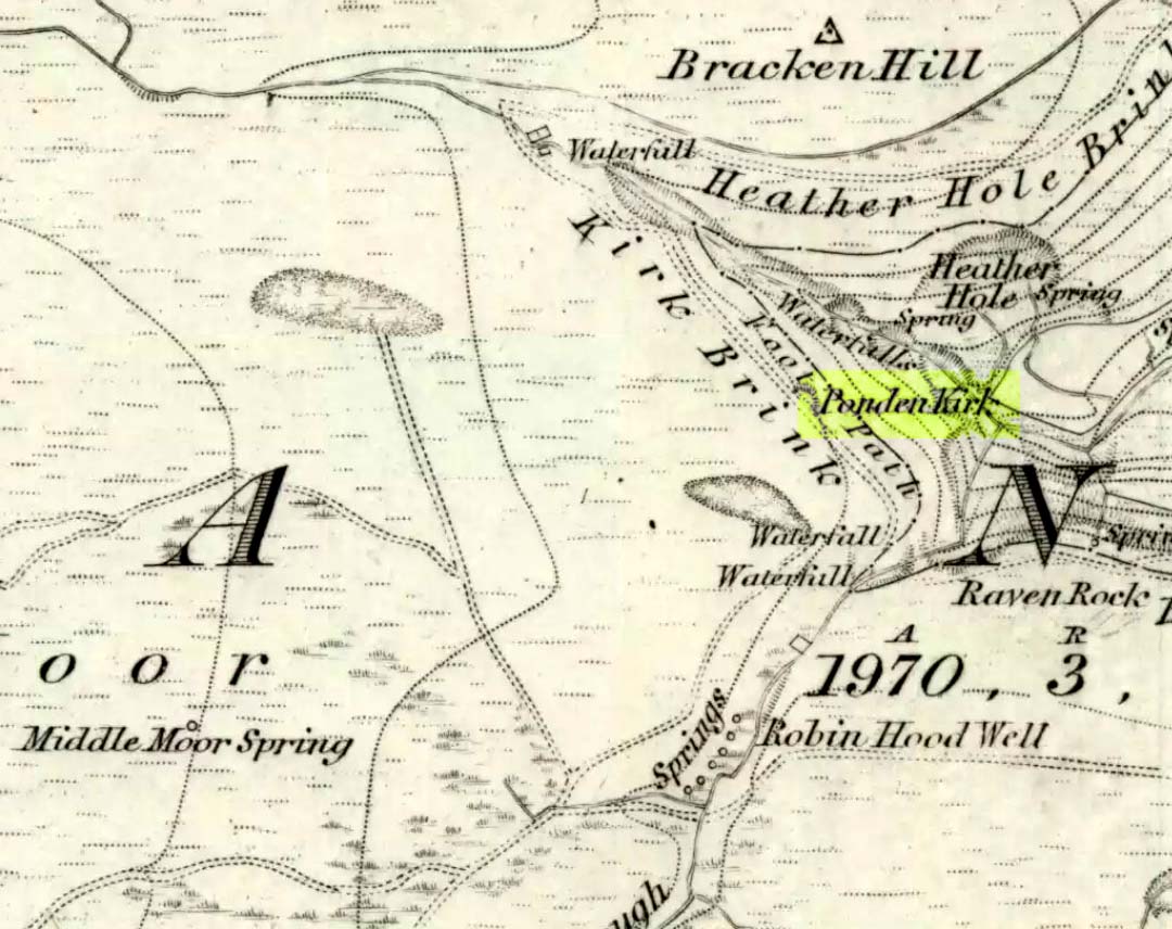
Go west through Stanbury village towards Lancashire for a mile till you reach the end of Ponden Reservoir. Where the water ends, follow the small track up to, and past, Whitestone Farm, till you reach the stream. Follow the valley up…
Archaeology & History
As the great Yorkshire historian J. Horsfall Turner (1879) told, “Ponden Kirk consists of a ledge of high rocks, dry in summer, but forming a stupendous cataract after heavy rain. It was here that Mrs Nicholls (Currer Bell) caught a severe cold shortly before her death.” The site is a fine one – not to be attempted from the base by unfit doods, unless you’re really serious about your climbing! But to those of us who like clambering up rocks and wholesome scenery, walk to the site via the stream (Ponden Clough Beck) and get to the cleft in the rock face. Tis a truly fine place!
Ponden Kirk from below
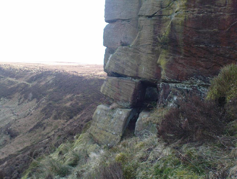
In 1913, one writer posited the notion that the opening in the rocks through which local folk crawl (see Folklore, below) “is seemingly artificial” – which aint quite true, sadly.
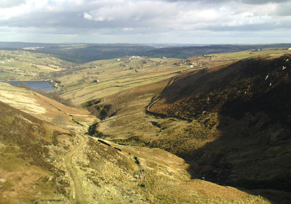
Once on the tops above the Kirk, you’ve one helluva decent view, be it raining or sunny. On the far northeastern horizon arises the great omphalos of Almscliffe Crags; and next to that is the elongated top of Baildon Hill; and a little further northeast is Otley Chevin. It would be good to visit here on a few of the old heathen days and watch the sunrise, just to see if there are any intriguing solar observations to be made! (take a tent though – or p’raps, if you’re like us, don’t bother, but you’ll be bloody cold for the night!) The only potential sunrises of heathen significance appear to be midsummer and Beltane….
Ponden Kirk on 1851 map
For me at least, one of the things which gives this site an intriguing form of sanctity is the fact that the Kirk itself forms the head at the end of the valley. It is a very fine ritual site and would obviously have had much more to be said of it than just the heathen marriage rites which are left today. The forces of wind and rain scream from its height, and in the valley beneath the chime of the gentlest echoes resonate, giving an altogether different ‘spirit’ amidst the same land. Those old cherubs of ‘male’ and ‘female’ spirit commune potently here – no doubt being the ingredients which gave form to the marriage customs… Those of you into feng-shui (the real stuff, not the modern bollox) and genius loci should spend time with the water and rocks here and you’ll see what I mean. Archaeologists amongst you, if you dare, should amble aimlessly here for sometime…for many hours, a few times, and give yourselves a notion of the ‘ritual landscapes’ you like to write about from the safety of your textbooks, to get a bittova better notion of what ‘experiencing the land’ is actually about.
Ponden Kirk’s opening
This rocky outcrop was also said to be the place that Emily Bronte used in her Wuthering Heights novel as the place called Penistone Crags. A couple of other local writers have also added this legendary place in their tales aswell.
Folklore
Alleged by Elizabeth Southwart (1923) “to be of druidical origin,” the first literary note of this great rock outcrop appears to come from the reverend James Whalley (1869) of Todmorden, who in his romantic amblings over the moorlands here, told that if any gentleman wants to get married,
“he must by all means pay a visit to Ponden Kirk… Here ‘they marry single ones!’ Any lady or gentleman who can successfully ‘go through one part of the rock’ (which is quite possible) is declared to all intents and purposes duly married according to the forms and ceremonies of Ponden Kirk.”
The view from the top
His wording here seems to imply that the event of passing through the rocky opening, is in itself a confirmation of the ceremony of marriage, not needing the blessing of some strange christian rites. If so, this tradition would be a very ancient one indeed, making the stone the witness to the marriage event. This would be a rite witnessed by the stones themselves: a universal heathen attribute found in most of the ancient traditional cultures. But this curious unwritten history was to be echoed a decade later by that great Yorkshire historian, J. Horsfall Turner (1879), who told us that,
“at Ponden Kirk, as at Ripon Minster, a curious wedding ceremony is frequently observed. It consists in dragging one’s-self through a crevice in the rock, the successful performance of which betokens a speedy nuptial… The place is now frequently called ‘Wuthering Heights. Apart from the association of such names as Crimlesworth and Oakden (see the Alcomden Stones), fancy easily ascribes a druidical settlement at the Kirk.”
A not unreasonable assumption – though nothing of this nature, of yet, has been found.
That other great Yorkshire writer, Harry Speight — aka Johnnie Gray (1891) — echoed the same folklore telling how,
“The natives of these parts have a saying, ‘Let’s go to Ponden Kirk where they wed odd ‘uns,’ which has its origin in an old custom of passing through an enormous boulder… The belief is that if you pass through it, you will never die single. No one knows how the rock acquired its name, but the Saxon kirk suggests a temple of worship, possibly extending back to the druidical times.”
Ponden Kirk – by T. MacKenzie, c.1923
A few years later, Mr Whiteley Turner came here and he too affirmed the old wedding rites, also telling that “according to tradition, maidens (some say bachelors too) who successfully creep through the aperture will be married within the year.” This bit of info also shows that the rocks also had oracular properties – a function known at countless other sites.
The proximity of Robin’s Hood Well, just a couple of hundred yards away, beckons for association with the Ponden Kirk – which it obviously had… But that’s a tale to be told elsewhere…
The reverend John Watson (1775) first wrote about this place, describing it as, “a group of stones, laid, seemingly, one above another, to the height of several yards, and called the Rocking stone.” Very little archaeological remains have been described hereabouts, save the odd flint scatters here and there. Anything which might have been here in the past was likely destroyed when the M62 was built right next to the site.
Folklore
The rocking stone was long ascribed in local tradition to be a site used by the druids. It was said that in bygone days the great boulder would rock, but this must have been a long time ago as even when Mr Watson described it, he told how “that quality is lost.”
Close by is the sometimes dried-up spring known as the Booth Dean Spa, which Watson thought might have been related to whatever ancient rituals occurred here.
References:
Watson, John, The History and Antiquities of the Parish of Halifax, T.Lowndes: London 1775.
The old Scottish folklorist, A.A. MacGregor, described this legendary rock, “by the Bridge of Luib, on the River Don,” in his classic Peat Fire Flame. (1937) One of the numerous ‘holed stones,’ it was one of countless rocks in our isles imbued with animistic spirit essence, akin to similar rocks found in all of the other cultures in the world. MacGregor told how,
“It happened that a man summoned to the death-bed of a relative came to this crossing-place just after torrential floods had carried away the bridge. When he was on the point of abandoning all hope of reaching the opposite bank, a tall man appeared from nowhere and volunteered to carry him across. The distracted homecomer accepted the assistance proffered. But, when he and his carrier reached mid-river, the latter reverted to the form of the river kelpie and endeavoured to drag him down to the river’s bed. The victim managed to escape. As he scrambled to the bank, the infuriated kelpie hurled after him the huge boulder that to this day goes by the name of the Kelpie’s Stane.”
But the stone was also known to possess healing and magickal properties, as evidenced from MacPherson’s (1929) chronicle, which told:
“Somewhere near Dinnet was the Kelpie Stone. Childless women passed through its 18 inch (46cm) hole to concieve. A noble lady performed the task to no avail; only when she repeated it in the same direction as the river flow did the charm work.”
Close by are several other intriguing place-names which may at some time have had some archaeo-mythic relevance to this legendary rock. On the hill above is the old Carn Lian; the water course nearby is the Allt na Ciste; but most intriguingly we find the Bog of the Old Woman, or the Moine Cailleach a half-mile to the east.
References:
MacGregor, Alisdair Alpin, The Peat-Fire Flame, Ettrick Press: Edinburgh 1937.
McPherson, Joseph M., Primitive Beliefs in the North-East of Scotland, Longmans, Green & Co: London 1929.
Described in 1926 by local antiquarian and early ley-hunter, W.A. (1926), as “a fallen monolith” — this old stone is probably just a glacial erratic. Found in the churchyard of St. Mary’s, tradition tells that in ages past young girls danced twelve times around this old stone, then placed their ears upon it to hear the answers to their questions and wishes. A similar legend tells how children danced around the stone seven times on a certain day of the year to conjure up the devil. Mr Dutt thought the great rock may have been “a ley or direction stone.”
References:
Dutt, W.A., The Ancient Mark-Stones of East Anglia, Flood & Sons: Lowestoft 1926.
Pretty easy to get to. Best thing to do really, is ask a local and they’ll send you in the right direction. From Bingley, take the Harden road (B6429) across the river. As it bends sharply left, note there’s a track going up into the woods to the right. Walk up it! Keep going and, unless you take a detour, you’ll end up at the rock outcrop eventually (where the woods come to an end, Druid’s Altar appears before you with the track running along its top-side).
Archaeology & History
Mentioned in the Tithe Awards of 1849, this lovely outcrop of rocks looking down the Aire Valley on the southern edge of Bingley has “an immemorial tradition” of druidic worship, said Harry Speight in 1898 – though quite when it first acquired such repute is outside of any literary record. In Sidney Greenbank’s (1929) rare book on this place, he could find little by way of archaeological data to affirm the old tradition, save the odd prehistoric find of flints here and there; though it is said that Beltane fires were burned upon the crags here in bygone centuries.
1894 photo of Druid’s Altar (courtesy Clive Hardy)
There was a 19th century account from the Ilkley Scientific Club where a member described there being a cup-and-ring carving “near the so-called Druid’s Altar, at Bingley,” but I’m unaware of the whereabouts of this carving and Boughey & Vickerman’s (2003) said nothing about it in their survey; though a possible cup-marking can be seen on one rock less than 100 yards west, which might account for the report. (a bit dodgy though!)
Folklore
Harry Speight (1898) makes what sounds like a rare flight of fancy when he described faerie being seen atop of the many oaks beneath the Druid’s Altar. In Clive Hardy’s (2002) work (from whence the old photo of the Altar is taken), he tells how “local antiquarians say that the cobbled way running from the Brown Cow Inn towards the site, is an old processional route walked by the druids.”
One, possibly two wells, each beneath the Altar rocks, are also reputed to have been associated with the old pagan priests, as their names tell: the Altar Well and the Druid’s Well – though the Altar Well has seemingly fallen back to Earth in recent years.
References:
Greenbank, Sidney, The Druid’s Altar, Bingley, R.G. Preston: Bingley 1929.
Hardy, Clive, Around Bradford, Frith Book Ltd: Salisbury 2002.


")


")