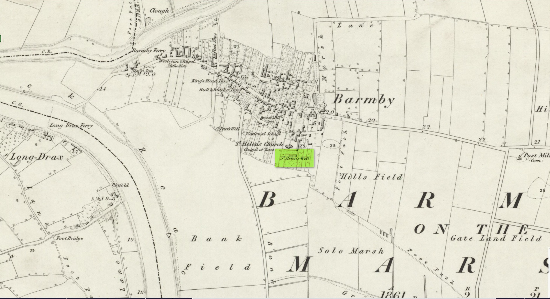
Holy Well (destroyed): OS Grid Reference – SE 6900 2841
Archaeology & History
Site shown on 1853 map
One of two holy wells in Barmby village which, like its compatriot St Peter’s Well, was destroyed sometime in the 19th century. Not good! It was located in the southwest section of the graveyard of St Helen’s Church and was apparently alive and running when the Ordnance Survey lads visited here in 1851 (as shown on their 1853 map). But when the site was revisited by them in 1905, it seems to have gone. However, as with the neighbouring St Peter’s Well, there are conflicting reports as to when it was destroyed, for although the Ordnance Survey lads spoke of it in the present tense when they went there, Thomas Allen (1831) told that “within the last six years (it has) been wantonly filled up.” Despite this, less than ten years later William White mentioned it in the present tense, also saying how it was “said to possess medicinal properties.” These healing qualities were, according to Allen, due to its iron-bearing or chalybeate nature, meaning that it would revive a weak and feeble constitution. Iron-bearing wells are damn good for such things!
As the years passed, St. Helen’s Well fell into folk memory. When William Smith (1923) surveyed the many holy wells in this part of the world he found how “old parishioners have said that as school-children they both drank of and washed in its water”, but little else.
References:
Allen, Thomas, A New and Complete History of the County of York – volume 2, I.T. Hinton: London 1831.
Gutch, E., Examples of Printed Folk-lore Concerning the East Riding of Yorkshire, Folk-Lore Society: London 1912.
Harte, Jeremy, English Holy Wells – volume 2, Heart of Albion press: Wymeswold 2008.
Smith, William, Ancient Springs and Streams of the East Riding of Yorkshire, A. Brown: Hull 1923.
White, William, History, Gazetteer and Directory of the East and North Ridings of Yorkshire, R. Leader: Sheffield 1840.
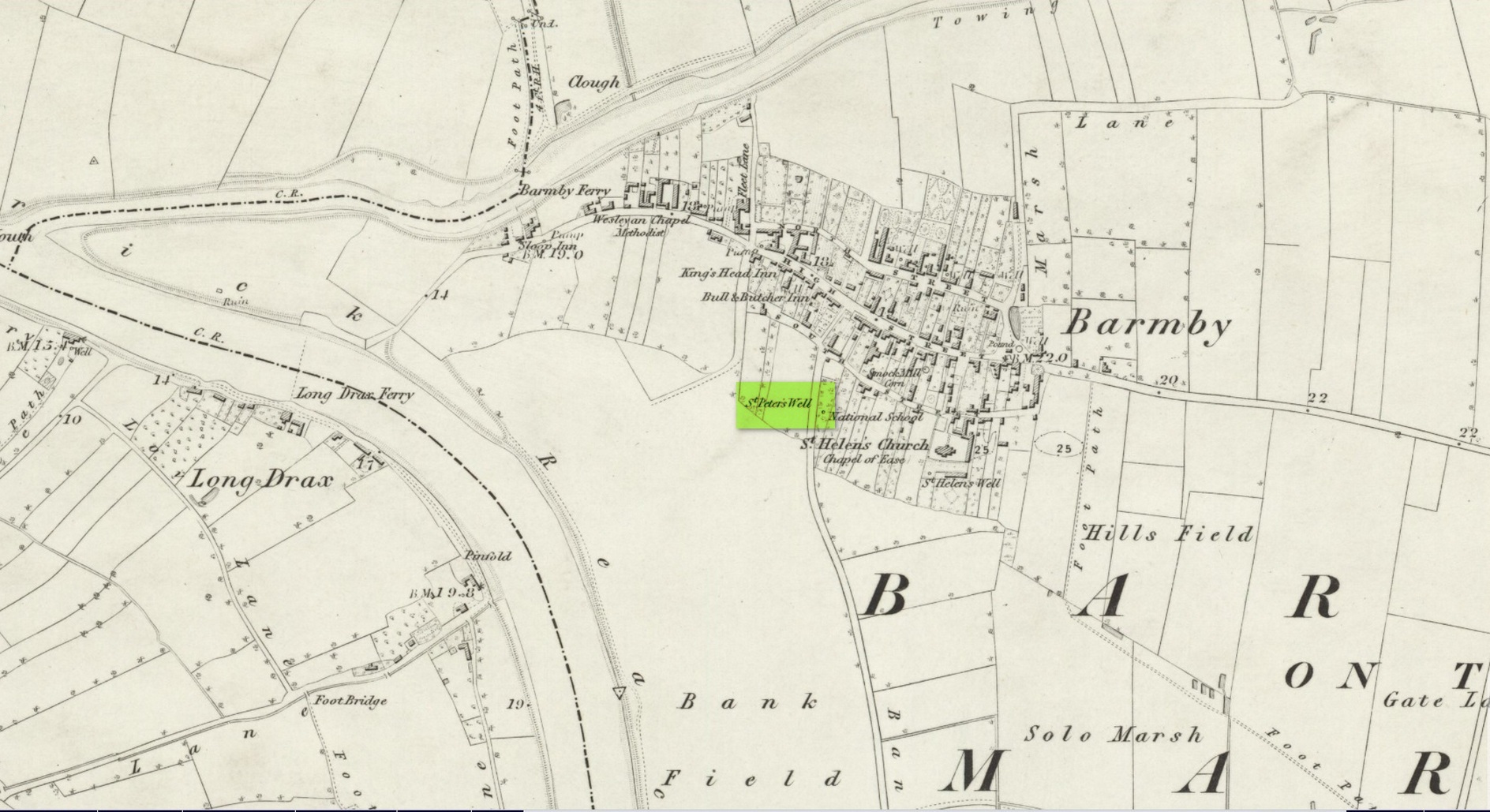
This holy well was one of two in the village of Barmby, neither of which seems to exist anymore — although, it has to be said, there are conflicting reports as to its demise from the word go. When it was first mentioned in Thomas Allen’s (1831) huge work on the history of Yorkshire he told us that,
“In this village are two extraordinary springs of sulphuric and chalybeate water, denominated St Peter’s and St Helen’s; the former possesses the rare virtue of curing scorbutic eruptions by external application. Both of these wells, within the last six years, have been wantonly filled up, and the site is only known to a few of the villagers.”
Their “extraordinary” waters however, were apparently found to be still flowing when the Ordnance Survey lads surveyed here in 1849, as they published it a few years later on the 1853 OS-map of the region, along with its nearby compatriot of St Helen.
Wet patch on 1907 mapSt Peters Well, Barmby 1853
Less than ten years earlier, Will White (1840) also spoke of St Peter’s Well, albeit briefly, telling that it “was said to possess medicinal properties”—but it seems that he never visited the site and was merely going on Mr Allen’s earlier description. Its exact whereabouts however, is somewhat of a curiosity. Although the Ordnance Survey lads mapped it as being SE 6885 2848 on the southwest side of the village, in William Smith’s (1923) survey of holy wells he gave us a very different location. “St Peter’s Well,” he wrote,
“is situated in an orchard about a hundred yards to the south-east of the church, and is reached by going through three fields. It is a pool about eight feet deep and fifteen in diameter, the spring now rising several yards from its original site. It flows clear and strong, and though attempts have been made to block it up, it always reappears. The water is soft and has never been known to freeze. It contains sulphur, as I can testify, having tasted the water. It is noted for curing scurvy and sore eyes, if applied externally, and half-a-century ago, people suffering from these ailments came long distances to apply the water as a remedy, and went away benefited. An eye-witness has said a man living far from Barmby, advised by his medical man, as a last resort visited the well and applied the water externally for the cure of scurvy, and so quickly did he lose the scales that fresh sheets for his bed were required each night…
“About a century ago, the owner of the orchard in which the well is situated had a son, a doctor, who commenced to practice in the district. The owner’s wife looked upon the spring as detrimental to the prospects of the son. So she said to her husband, “Tummus, we’ll hev that well filled oop. Foaks can cure thersens, an’ ther’ll be nowt fur poor Tummy ti dea.” Tummus was so convinced by his wife’s foresight that he did as she wished, and filled up the well.”
Naathen, on the very first OS-map of the village, the lads marked it at SE 6885 2848, as well as on subsequent surveys. This spot is 170 yards west of the village church wall. The location described by Smith has no “well” or spring marked on any maps, but, on the 25-inch scale map, 100 yards southeast of the the church walling we see marshland on the other side of a copse of trees in the very spot he told us about. Whether or not this was the actual spot, or whether the OS-lads had it right, we might never know. Field-name surveys may help; the existence and location of the orchard may help; other literary accounts might also be useful. But, one final query that may be important relates to Tom Allen’s (1831) words when he told us that “the site is only known to a few of the villagers.” By that, did he mean that the local folk kept its position quiet from outsiders? Even today, in our numerous inquiries with local people in the glens and mountains when seeking out lost or forgotten places, we still come across some olde local folk who are still quite hesitant, with that serious quizzical look in their eyes…
Folklore
St Peter’s day was celebrated on June 29. He was one of the so-called “major saints” due to him being one JC’s Apostles. His symbol was a key.
References:
Allen, Thomas, A New and Complete History of the County of York – volume 2, I.T. Hinton: London 1831.
Gutch, E., Examples of Printed Folk-lore Concerning the East Riding of Yorkshire, Folk-Lore Society: London 1912.
Harte, Jeremy, English Holy Wells – volume 2, Heart of Albion press: Wymeswold 2008.
Smith, William, Ancient Springs and Streams of the East Riding of Yorkshire, A. Brown: Hull 1923.
White, William, History, Gazetteer and Directory of the East and North Ridings of Yorkshire, R. Leader: Sheffield 1840.
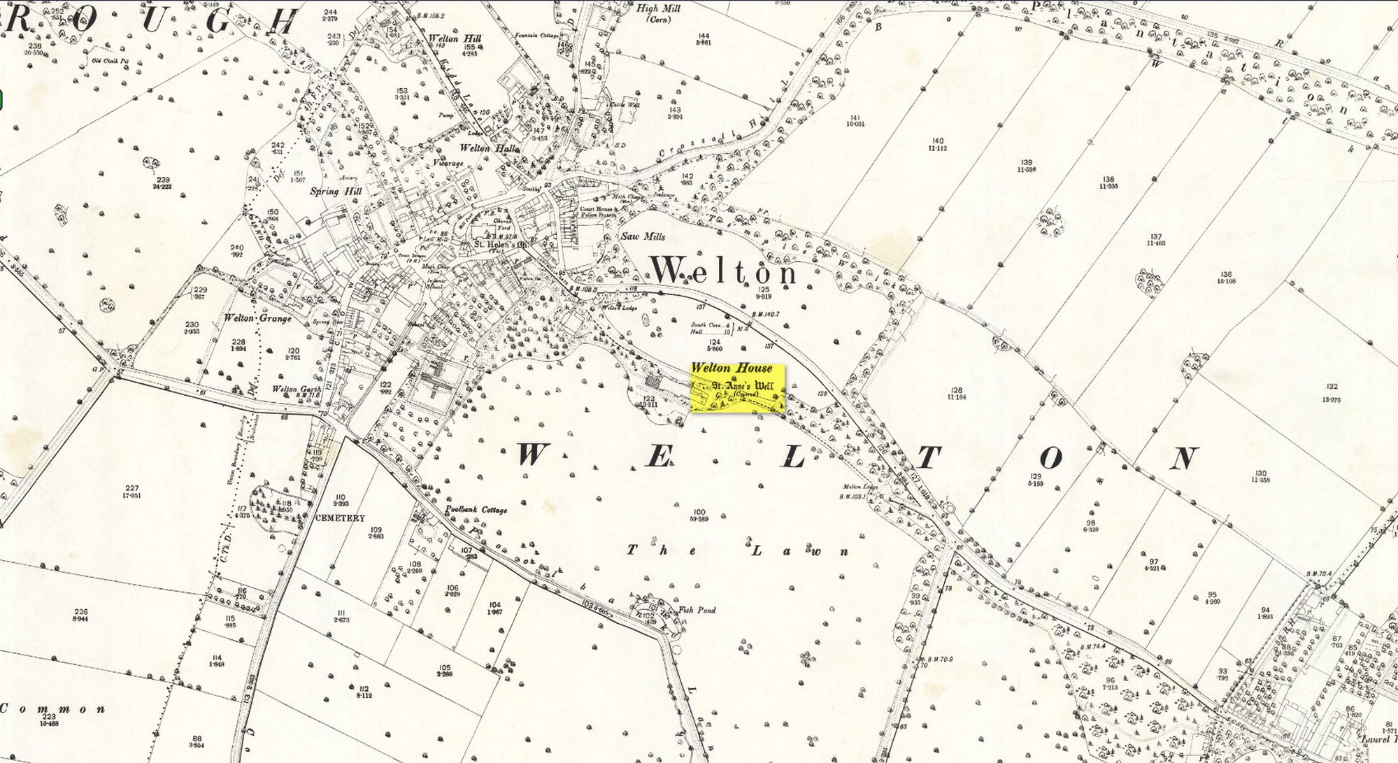
Shown on the early 25-inch-to-the-mile Ordnance Survey map of the area, this is a frustrating site. In Thompson’s (1870) early history of Welton village, he says very little about this place, other than:
“Then there is Saint Ann’s Well, which supplies Welton House with spring water.”
Site shown on 1890 map
Even worse is the fact that in William Smith’s (1923) survey of East Yorkshire holy wells, he merely copies Thompson; and in Jeremy Harte’s magnum opus he does exactly the same thing! Not good. Thankfully the local artist and singer, Gaynor Perry, helped us out big time! She grew up in this area and used to play here when she was young, but at the time she had no idea that the well where she’d played had any magical traditions attached to it. This discovery happened many years later. Regarding the present condition of the well (as of 2017), she told:
“The well has been covered with stone slabs for a long time (and) a tree has tried to grow over it. It has been sheltered here over the years in the grounds of Welton House, a large estate which was demolished in 1952.”
The well can still be seen in the small copse of trees immediately north of St Anne’s College. There is the possibility that this holy well gave its name to the village of Welton itself. First mentioned in 1080 CE, the place-name means “the well near the farm,” (Smith 1937) although there is no direct linguistic association with St. Anne, so we don’t know for sure.
Folklore
St. Anne is a curious saintly figure and one of my personal favourites. St Anne (saint’s day – July 26) was a giant in early christian and Islamic myths. An apocryphal figure, She was the Great Mother of the mother of Christ—the Virgin Mary—and was Herself a Virgin until, in Her old age, after seeing a bird feeding a chick, decided She wanted a child and so eventually gave birth to Mary. An old woman giving birth when the Springtime appears (when birds and other animals become fertile) is the same motif found in the lore of the Cailleach in Ireland and Scotland (and parts of northern England). A pre-christian mythos was obviously at play here in bygone times…
Tumulus (destroyed): OS Grid-Reference – TA 420 150
Archaeology & History
This long lost site is one of probably many such sites on the east coast of Yorkshire and Lincolnshire that used to exist, before the great North Sea took them away. The only account I’ve found of this one is from a short article in an early copy of the Lincolnshire Notes & Queries magazine by John Cordeaux (1891), who wrote:
“The Spurn, or Spurn Point, as it is now usually called, at the mouth of the Humber, is so closely connected with Lincolnshire history that it is unnecessary to apologize for recording in Lincs. N. & Q. an interesting sepulchral relic found there. This is a rude chest or coffin, roughly hewn and squarely hollowed, probably with stone implements, from the trunk of an oak, recently exposed by the action of the sea on the beach at Kilnsea. The total length overall of the chest is 51 feet, the interior (it was much decayed and fallen when I saw it) little, if anything, over four feet. In this space the skeleton, presumably of an adult male was found doubled up. Most unfortunately the original finders (labourers) scattered the bones, which subsequently were washed away. A thigh bone alone being recovered, and this is suggestive of a man probably a little below the average height.
“From oral evidence collected in the neighbourhood, I came to the conclusion that the body must originally have been buried with the head bent forward on the chest, and the legs tucked up like a trussed fowl, the knees near the chin. No corresponding lid or covering was found on the coffin, it had been placed in an excavation in the red or chalky boulder clay, and tenacious blue clay placed on it. The locality on the coast where it was found represents the Pit Marshes — that is before “the sea gat ’em ” — their position was about one-hundred and fifty yards south of the first sea-groin on Kilnsea beach. It is not improbable that a barrow or tumulus, either of earth or piled stones, at one time covered the interment, until levelled and dispersed by the sea’s encroachments on the land. Not far from this place on the beach, a small, simple, flat-sided celt, about four inches long, was picked up. It may or may not have borne some relation to the occupant of the oak coffin. When the foundations of the enlarged Chancel of St. James’ Church, Grimsby, were dug, a similar coffin or chest was exposed, partly within and partly without the line of the north chancel wall. I remember it was conjectured at the time, from the comparatively small interior, that it had been used for the interment of a child. It is more probable, however, that it had once contained an adult packed away in the manner indicated at Kilnsea.”
A very short distance north we find the place-name of “How Hill”, which may be a record its existence, as the word how in many places round here can mean a tumulus. Seems to make sense.
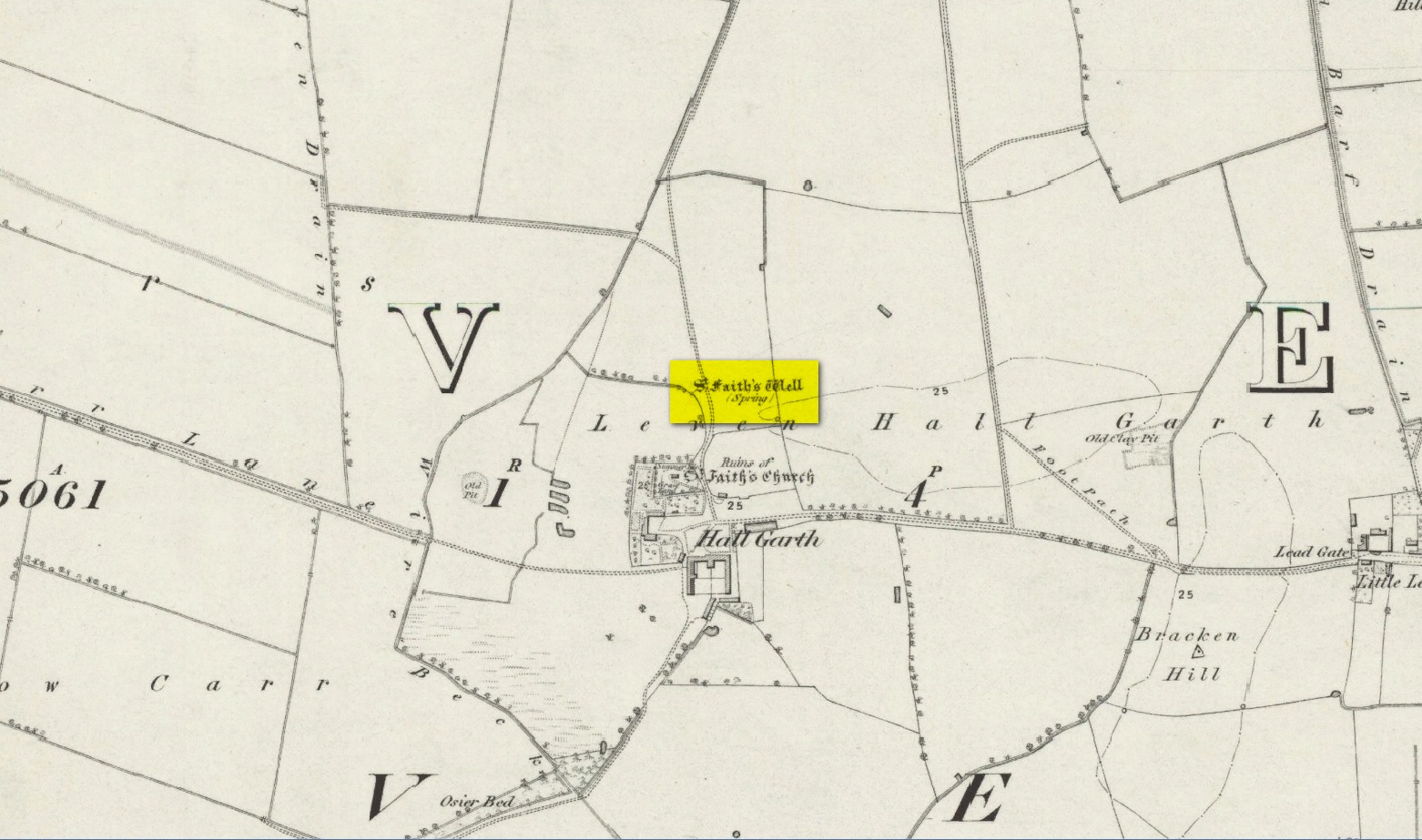
The site of the well is on the Carrs to the west of Leven village, immediately north of the old cemetery adjoining Hall Garth house. Reverend William Smith, writing in 1923, told us:
St Faiths Well on 1855 map
“St Faith’s Well lay on the left of the road known as St Faith’s Lane, which leads to the old churchyard to which the spring was near. St Faith belonged to France, and when quite a young maiden, was martyred because of her christianity. She lived and died in the third century….
“St Faith’s Well was filled in about a hundred years ago and the site lost. This, however, has lately been approximately fixed by the aid of water divining. A Leven man, who can wield the hazel wand, went over the ground near to which the well was thought to have been, and the wand indicated a spot under which, on digging to the depth of about three feet, “the water fairly bubbled up”, and it was judged this was the place where the well lay. St Faith’s Well is said to have given water both pure and abundant, and to have been in the old days the only supply of drinking water to the people of the Carrs.”
St Faith’s Saint’s day is the 6th October and she was a saint whose patronage was invoked by pilgrims, prisoners and soldiers. From this, is it perhaps reasonable to infer that St Faith’s Well may have been a station for pilgrims to the local shrines of St John of Beverley and St Philip Ingleberd at Keyingham? Also a stopping point for fugitives seeking sanctuary at Beverley?
There was another holy well dedicated to St Faith at Hexton in north Hertfordshire.
References:
Cox, J.Charles, The Sanctuaries & Sanctuary Seekers of Mediæval England, George Allen: London 1911.
Farmer, David H., Oxford Dictionary of Saints, Oxford University Press: Oxford 1987.
Smith, Rev. William, Ancient Springs & Streams of the East Riding of Yorkshire, A. Brown: Hull 1923.
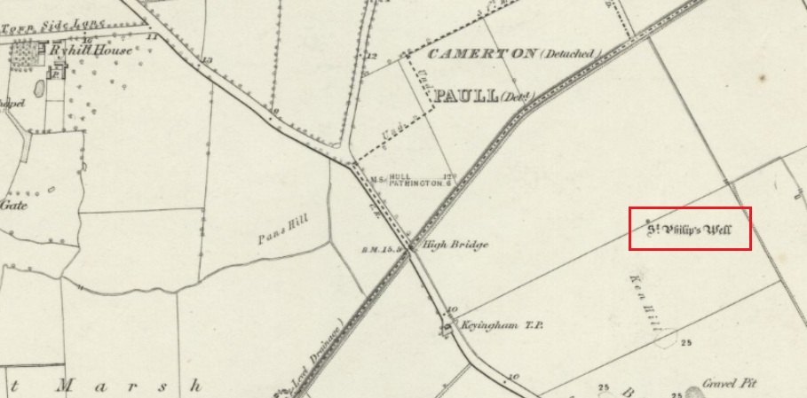
Holy Well (destroyed): OS Grid Reference – TA 23584 25549
Archaeology & History
The Well shown on the 1855 6″ OS map
This holy well was formerly on the northern boundary of a field adjoining the north side of the A1033 west of Keyingham.
In view of the surviving folklore relating to the well it seems that its dedication to St. Philip may have been an effort by the Church to ‘Christianise’ it; and the St Philip here is not the Biblical Apostle, but a local saint – Philip Ingleberd (died c.1325 and also known as Philip Inglebred), whose memory was celebrated by a nearby Cross and a shrine at St Nicholas Church in the village. The well and the cross may have been dedicated some time after 1392 following a ‘miracle’ relating to Philip’s tomb. These were destroyed by the mob in the Reformation, although the cross-base survives. It seems the well may have been restored in the late seventeenth century. By the early twentieth century the well was described as laying on the Common to the west of the village, by then filled in, only showing signs it ever existed by making the ground near its site wet and boggy in a rainy season.
Folklore
George Poulson writing in 1841 told that,
“…a few fields more to the west is a well, called St. Philip’s Well; on a small stone are inscribed W. H. W. D. IG67. W. K. It is called the wishing well; and the country lasses were in the habit of dropping pins, or even a sixpence into it, for the purpose of ensuring to themselves either particular or general good luck.”
William Smith (1923) described the well as one of six wishing wells or pin wells in Yorkshire and, moreover, the only ‘Cross Well’ in the East Riding. At none of these wells was evil allowed to be foreshadowed, and the wells were only to show to a girl the portrait of her future husband. He told us that,
“In every case the wish had to be with truthful devotion, and not divulged to any living person, or the desired consummation would not be gained…. Tradition adds that the well was much visited by maidens, who, on dropping their pins or coins, expressed the wish to see their lovers mirrored on its waters. Thus they kept a custom, dating to the time when the well was counted to be under the control of the fairies.”
And as Keyingham Common was once the abode of the fairies, it is worth noting that some 700 yards west of the site of the well a ‘Pans Hill’ is shown on the old maps, although whether this rural spirit of classical myth ever made it up to the East Riding is altogether another matter….
References:
Arrowsmith, Nancy & Moorse, George, A Field Guide to the Little People, Macmillan: London 1977.
Hope, Robert, Legendary Lore of the Holy Wells of England, Elliot Stock: London 1893.
Poulson, George, History and Antiquities of the Seigniory of Holderness, Thomas Topping: Hull 1841.
Smith, Rev. William, Ancient Springs & Streams of the East Riding of Yorkshire, A.Brown: Hull 1923.
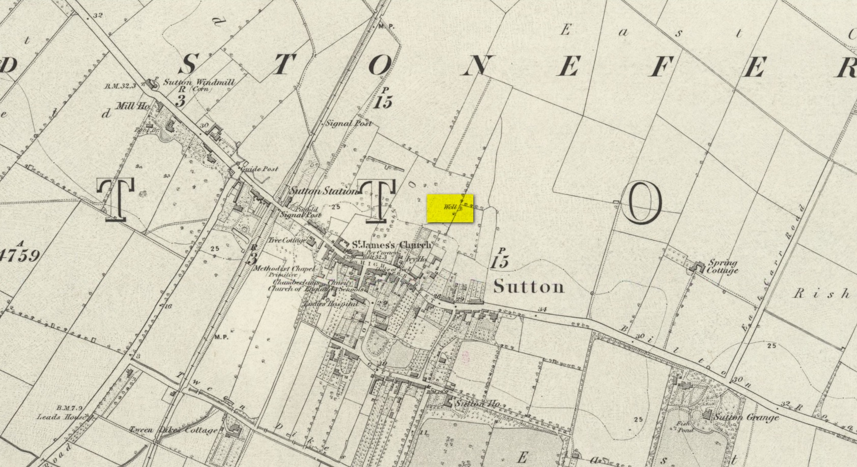
We don’t know for certain the precise whereabouts of this long lost healing well, but it would seem to be the one highlighted here (right) on the 1855 OS-map. However, I think it equally possible that the small unnamed building, roughly halfway between the highlighted ‘Well’ and Spring Cottage, where the walling meets, could be the site in question. It’s one or the other!
Folklore
When Thomas Blashill (1896) wrote of the Blind Well in his standard history work of the area, memory of it was already falling away. In discussing where local people could wash and look after their health, he told that
“There was one place in the parish where washing seems to have been practised as a curative measure. Down in the East Field, near to Spring Cottage Farm, was the Blindwell, to which the people had access. If they used its waters freely when suffering from sore eyes, their faith would probably be rewarded.”
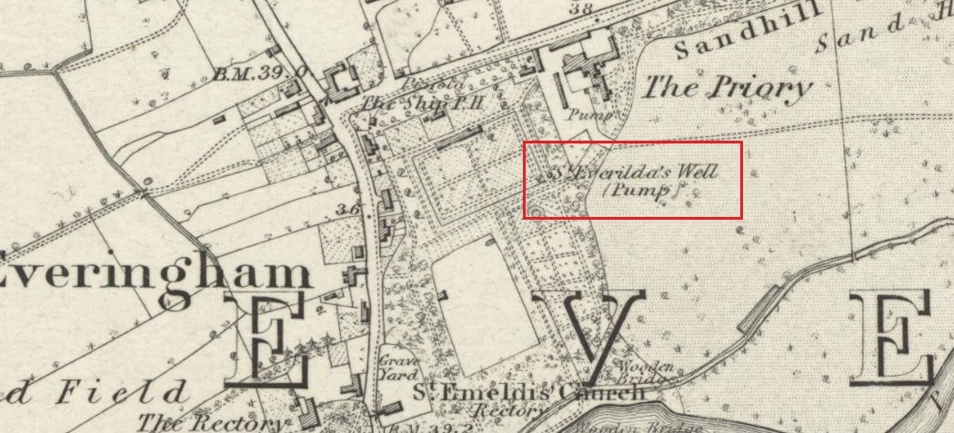
Holy Well (destroyed): OS Grid Reference – SE 80528 42531
Also Known as:
St Everildis Well
Archaeology & History
Shown on the 1855 Ordnance Survey map as a ‘pump’, in the grounds of Everingham Priory, the ‘seat’ of the lord of the manor, it was in an enclosure formerly open to the people of the village. It was filled in prior to 1923. The water was described as ‘abundant and excellent.’ Graeme Chapman, in his Yorkshire Holy Wells website states:
‘A few metres to the south of the site of the well the modern OS map marks the start of a stream (SE 8055 4250) which could be the original source of the Holy well’s water.’
The well shown on the 1855 6″ OS Map.
The present writer has not been able to verify this from the materials available to him.
Everilda, also known as Everild and Averil, is recorded in the York Breviary, printed in 1493. She was a mid Yorkshire Saint who died around 700 CE. According to this source she was of a noble Wessex family who went to Yorkshire with companions Bega and Wulfreda, settling on land called Bishop’s Farm, an estate of the Bishop of York, St Wilfrid , which he gave to them, the place being then called Everildisham. There they established a nunnery, of which all trace is now lost. Her Saint’s day is July 9th. The name of St Everilda has been changed to ‘Emeldis’ in the dedication of the church at Everingham. Some historians claim the village is not named after her, but as a derivation of ‘ham of Eofor’s people’. The only other church known to be dedicated to her is at Nether Poppleton, some 17 miles north west of Everingham.
Folklore
The water of the village and the mothers of Everingham are said to have been blessed by St Everilda, and the Reverend Smith wrote that over a fifty year period, no mother had died in childbirth.
References:
Farmer, David, The Oxford Dictionary of Saints, Oxford University Press, Oxford, 1987
Raine, James, The Dedications of the Yorkshire Churches, The Yorkshire Archaeological and Topographical Journal, Vol II, 1873
Salisbury, Matthew Cheung, The Use of York: Characteristics of the Medieval Liturgical Office in York, Borthwick Institute, York, 2008
Smith, Rev William, Ancient Springs & Streams of the East Riding of Yorkshire, A.Brown & Sons, London, Hull & York, 1923
Tumulus (destroyed): OS Grid Reference – TA 0584 6128
Archaeology & History
Ruston Beacon tumulus on 1854 map
A fallen tumulus that once marked the southwestern side of the village boundary line, and was once adjacent to the prehistoric Green Dikes earthworks that once passed here. Sadly however, sometime early in the 20th century, this ancient burial mound fell victim to usual ignorance of arrogant land-owners who place money ahead of history and local tradition and it was ploughed-up and destroyed. Thankfully we have an account of the site in J.R. Mortimer’s (1905) incredible magnum opus. Listing it as ‘Barrow no.272’ in the number of tombs excavated, he told us that:
“It is situated on elevated ground about half-a-mile (south)west of Ruston Parva. On September 20th and 21st, 1886, it measured about 70 feet in diameter and 2 feet in elevation; and had originally been several feet higher, as an old inhabitant remembered assisted in removing its upper portion, which was carried away and spread on the surrounding land many years previously. At the base of the barrow, near the centre, was a long heap of cremated bones which had been interred in a hollow log of wood with rounded ends, about 3 feet in length and 14 inches in width, well shown by impressions in the plastic soil, and by the remains of the decayed wood. The heap of bones was rather large and probably consisted of the remains of more than one body. No relic accompanied them. Several splinters and flakes of flint were picked from the mound.”
The tumulus (as its name implies) became a spot besides which one of East Yorkshire’s many ancient beacons were built. In Nicholson’s (1887) survey of such monuments, he told that
“the modern beacon, apparently, stood on the site of the old one, on the high ground in the angle of the road from Driffield to Kilham. It was a prominent object and would be well-known to the coachmen and guards…for it stood on the side of the road from Driffield to Bridlington. Mr John Browne, of Bridlington, remembers it; and says, ‘It would be the last of the beacons that remained in this district and was removed between fifty and sixty years ago. My recollection of it is that it was a tall pole, with a tar barrel at the top, and had projected steppings to reach the barrel.”
One of the earliest accounts of the beacon from the late-1500s told that it took signal for its light from the beacon at Rudston, which stood upon one of the Rudston cursus monuments, a short distance from the massive Rudston monolith.
References:
Mortimer, J.R., Forty Years Researches in British and Saxon Burial Mounds of East Yorkshire, Brown & Sons: Hull 1905.
Nicholson, John, Beacons of East Yorkshire, A. Brown & Sons: Hull 1887.
Tumulus (destroyed): OS Grid Reference – TA 4160 1748
Archaeology & History
In and around East Yorkshire, the fabled Yorkshire antiquarians William Greenwell and J.R. Mortimer uncovered and excavated many now-lost prehistoric tombs—some of which, beneath the rounded tumulus of earth, were constructed out of wood instead of stone. A little-known site, now long gone, once existed in what is now the North Sea, just a few hundred yards off the Easington coast. Other sites close by are soon to be completely swallowed back into Earth’s body, right on the water-line, but the site described here has long gone. What little was known of it was described in Mortimer’s (1905) magnum opus, where he told:
“On the beach at Easington, in Holderness, under a tide-demolished barrow, Dr Hewetson and the writer on April 21st, 1894, discovered a double cist made of broad slabs split from the outer shell of the decayed trunk of a willow tree. This barrow had been swept away by the waves, and its site was at about half-tide-line, and a considerable way from the very low cliffs. Lining the grave with wood (the branches of trees) would not be difficult to accomplish and would be practised as a protection to the body.”
A henge monument and several other prehistoric barrows have been located in and around Easington, but they’re fading fast!
References:
Mortimer, J.R., Forty Years Researches in British and Saxon Burial Mounds of East Yorkshire, A. Brown: London n.d. (1905).