Standing Stone (lost): OS Grid Reference – SU 161 432
Archaeology & History
In William Stukeley’s Stonehenge, he described a number of monoliths outlying Salisbury Plain that also possessed a prehistoric pedigree. Most of them have been recorded, but this one seems to have been forgotten about — perhaps by virtue of it having fallen into the River Avon! Edgar Barclay (1895) described it in his fine survey, saying:
“In the bend of the river below the village, is a large submerged stone; only during drought is any portion of it visible above water; it can, however, in ordinary times, be dimly seen from the bank, which is of chalk, here very steep and overgrown. The country people assert that a metal ring, “turning always,” is let into its upper end. Legend relates that when the Devil brought the rocks of Stonehenge from Ireland, tied together with withes, this stone escaped from the bundle and fell into the river. Its position forbids the belief that it got fixed in the bed of the stream when its passage to Stonehenge was being attempted, for it lies immediately beneath the crest of a very steep bank, and at its most inaccessible point; as the stream sweeps against this, the water must always have been deep at this spot, the open valley would everywhere offer more favourable points for such an operation, especially would this be the case before the Avon was dyked. A boundary stone would have been placed on the brow of the hill; if the stone be a grey-wether, as report says, and as is probable, it may originally have stood on the bank, and “once upon a time”, a ring having been fixed in it, it may have been dragged into the stream to moor a ferry-boat. It lies closely midway between the stone on Bulford Down and that in Durrington fields.”
One wonders if any local people might know more about this…
References:
Barclay, Edgar, Stonehenge and its Earth-works, D. Nutt: London 1895.
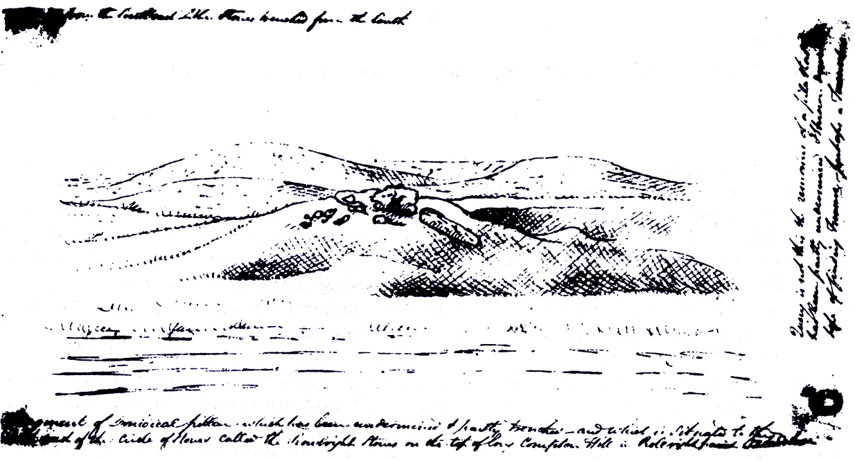
Tumulus (destroyed): OS Grid Reference – SP 2946 3090
Archaeology & History
Only known drawing of Gough’s Barrow
In days of olde there were heathen sites around the edges of the beautiful Rollright Stones complex that have sadly fallen prey to the intensive agriculture of more modern ‘civilized’ times. It’s become the way of things….. One site of importance in this geomythic pantheon was the ‘Gough’s Barrow’—so named after a drawing was done of the site by Richard Gough, editor of the 1789 edition of Camden’s Britannia. As far as I’m aware, it is the only one ever done of this monument. The Oxford archaeologist George Lambrick (1988) saw “every reason to accept the position and details of the barrow”, upon which stood at least two large stones—one of which gained the description of a ‘druidical pillar.’
Stukeley’s 1743 drawing
The same barrow may have been recorded in one of drawings of the great William Stukeley, who visited the Rollright Stones in 1710 and then again in 1723. On the left-side of the adjacent drawing you can see a denuded mound close to the edge of the picture, similar in shape and form to that drawn by Richard Gough. It is probably the same tumulus or barrow. Trial excavations at the site in 1983 looked for any remains of the old tomb, but nothing significant was uncovered. Lambrick estimated that the site probably measured “about 18m wide and 20m long east-west,” and “was a megalithic barrow and was therefore probably Neolithic in origin.”
References:
Bennett, Paul & Chanter, James, The Complete Rollright Stones, forthcoming
Bennett, Paul & Wilson, Tom, The Old Stones of Rollright and District, Cockley Press: Chipping Norton 1999.
Burl, Aubrey, Great Stone Circles, Yale University Press 1999.
Lambrick, George, The Rollright Stones, English Heritage 1988.
Stone Circle (destroyed): OS Grid Reference – SU 0986 6713
Archaeology & History
Smith’s plan of the site
This all-but-destroyed megalithic ring is all-but-unknown in most of the archaeological gazetteers — including even Burl’s (2000) magnum opus! But we know it was there. And according to the Avebury authority Pete Glastonbury , there “are a couple or three small stones buried on the hill but nothing else to see.” Which is a pity, as the site sounds like it was something to behold in bygone times. Although it seems to have been described initially by the legendary druidical antiquarian, William Stukeley, a more lengthy description followed in the 19th century by the reverend A.C. Smith (1885), when he and a friend took it upon themselves to cut back some of the turf that was covering a number of stones — and they weren’t to be disappointed!
The site itself appears to have stood right on the southern boundary line of Avebury parish, meaning that the site could have been named and cited on any early boundary perambulation records that might exist of the parish. (do any of you Wiltshire folk have access to any such old records?) But if there are no such early accounts, the earliest record we’ll have to stick with is good old Mr Stukeley (1743), who only gave it a passing mention, saying:
“Upon the heath south of Silbury was a very large oblong work like a long barrow, made only of stones pitch’d in the ground; no tumulus. Mr Smith before-mentioned told me his cousin took the stones away (then) fourteen years ago, to make mere (boundary, PB) stones withal. I take it to have been an Archdruid’s, tho’ humble, yet magnificent; being 350 feet or 200 cubits long.”
Nearly 150 years later Reverend Smith gave us a more detailed account, and ground-plan, describing the place as,
“a stone circle, of considerable dimensions, though imperfect and formed of very small sarsens, but which I believe to have been in some way connected with Abury. Though it appears to have been mentioned by Stukeley one hundred and fifty years ago, it had been long since buried, and completely forgotten till I was fortunate enough to discover it by digging in the year 1877. I was led to the discovery by the suspicious look of certain stones which, though scattered in no regular form, appeared as if they might have once stood erect, in some sort of order, on the segment of a large circle. I had often stopped to examine them as I wandered over that part of the downs; till at last previous suspicions ripened into conviction, as closer observation revealed sundry other stones just showing above the ground, and there also seemed to be faint indications of a trench, all pointing, with more or less accuracy, to the supposed circle. Not to dwell upon the details of the investigation, which, however, were of singular interest to me, the result was that (with the permission of both owner and occupier of the land, and assisted by Mr William Long), I probed the ground in every direction, and uncovered the turf wherever a stone was found: and on our first day’s work we unearthed no less than twenty-two sarsen stones, all forming part of the circle, and lying from two to twelve inches below the surface. These stones were all of small size, some of them very small, but that they were placed by the hand of man in the positions they now occupy, in many cases nearly touching one another, and that they formed part of a large circle or oblong, admits, I think, of no doubt. I say part of a circle, because, though the northern, southern and eastern segments are tolerably well defined, I could find scarcely a single stone on what should be the western segment to complete the circle. That the area thus enclosed is not insignificant will appear from the diameter (in length, or from north to south, 261 feet; and in breadth, or from east to west, 216 feet). Again, its position (due south of Silbury, and within full view of it, as well as the Sanctuary on Overton Hill, and with Abury immediately behind Silbury, due north of it, from which also Silbury is equidistant) seems to intimate that it may have had some connection with the great temple.”
A ley running through the circle (image courtesy Paul Devereux)
Smith then proceeded to query the nature of the monument, commenting on how Sir John Lubbock and members of the British Archaeological Association were intrigued by the remains, but a little perplexed and unable “to form any opinion” as to the exact nature of the site. But this didn’t stop mythographer and historian Michael Dames (1977) who, in his classic Avebury Cycle, suggested that the site “marked the navel of the landscape goddess” in the region.
The site didn’t go unnoticed in Devereux and Thomson’s (1979) classic Ley Hunter’s Companion, where it plays an important point along a ley that runs north-south for 13 miles between Bincknoll Castle at the north, to Marden Henge at the south. Such an alignment had been noted much earlier by other archaeologists and historians.
The site does look strange for a stone circle in Smith’s ground-plan and has more the hallmarks of a type of enclosure or settlement of some sort. It certainly wouldn’t be out of place, design-wise, as a prehistoric settlement in our more northern climes. However, without further data it seems we may never know the true nature of this old stone site…
References:
Dames, Michael, The Avebury Cycle, Thames & Hudson: London 1977.
Devereux, Paul & Thomson, Ian, The Ley Hunter’s Companion, Thames & Hudson: London 1979.