Follow the same directions to get to the Corrycharmaig 3 carving; and just a yard or two to the right of the far western edge of the rock, you’ll see another smaller slightly sloping rock, closer to the fencing, with faint cup-markings. That’s the one! (note that the 10-figure grid reference given here might need adjusting slightly)
Archaeology & History
This small slightly sloping piece of exposed rock is on the western extremity of the Corrycharmaig cluster of carvings, but is a distinctly separate piece of rock from the Corrycharmaig 3 stone (though part of the same outcrop). The stone itself has two sections to it, with a natural crack in the rock defining eastern and western section — both of which possess cup-marks.
The easternmost section of the stone has seven cup-marks, some of which were only recently uncovered. A large single cup-mark sits near the middle of this portion of the rock; this is probably what Mr Cormack (1952) was talking about when he told that, “further west (of the Corrycharmaig 3 carving, PB) is one isolated larger cup of 4-inch diameter.” On the western side of the stone, we find just two or three cup-marks, though one large cup-marking here would seem to be Nature’s handiwork.
It is highly likely that beneath the excessive vegetational growth around this carving and others along this ridge, other sections of prehistoric carvings remain to be found.
Morris, Ronald W.B., The Prehistoric Rock Art of Southern Scotland, BAR 86: Oxford 1981.
Royal Commission on the Ancient & Historical Monuments of Scotland, Archaeological Sites and Monuments of Stirling District, Central Region, Society of Antiquaries of Scotland 1979.
On the A657 road, a half-mile past Greengates towards Calverley, just before the road starts going uphill, take the lower dirt-track of Eleanor Drive on your left into Calverley Woods (here known as West Woods). About 150 yards along the track, note the small footpath on the right which goes up diagonally further into the trees. Go along here until you reach the remains of a dried-up pond on your left. The carved stone is about 10 yards before the pond, just above the footpath.
Archaeology & History
Rubbing of the 2 cupmarks
Another stone only for the puritans amongst you! This (and the West Woods 2 carving) was one we found in 1985 when we were exploring the woods looking for the Calverley Woods cup-marked stone reported by Sid Jackson in the 1950s. The stone is a small roughly oblong, earthfast rock, about 2ft by 1ft across, and has two distinct but faded cup-marks on its slightly sloping face. That’s it!
Soon after first finding this, we made a couple or rubbings of the stone, one of which I reproduce here and which shows the two cup-marks. You’ll note the measurement and note of the cups being 2 megalithic inches (MI) in diameter. The MI was a statistical unit of measure suggested by the late great Alexander Thom, who found regular integers of 2.07cm in many of the cup-and-rings he examined, and so surmised it as a deliberate numeric system. At the time when we found this cup-marked stone, I was exploring Thom’s idea and was very much taken up with it. However, after a few years doings numerous rubbings of the many cup-and-ring stones in West Yorkshire, and exploring the simple size of the human hand and how we execute cup-markings on rocks, I found Thom’s idea didn’t seem to be realistic. (though I still love Thom’s works: the man was an outstanding researcher, far exceeding all the archaeologists of his period in terms of his exploratory methods)
References:
Bennett, Paul, “The Undiscovered Old Stones of Calverley Woods,” in Earth 2, 1986.
Cup-and-Ring Stone: OS Grid Reference – SO 9875 2825
Archaeology & History
Nottingham Hill cup-and-ring
A rare find this! In October 1981, in deepest Gloucestershire on the edge of the Nottingham Hill Iron Age hillfort, archaeologists sifting through what they ostensibly called “occupational debris” along the western edge of the huge enclosed monument, found a singular piece of local oolitic limestone etched with an archetypal cup-and-ring design! The carving was on a typical ‘portable’ piece of stone and would not have been amiss had it been uncovered in a neolithic or Bronze Age cairn in our more northern climes. But this southern example is something of an anomaly.
In Morris & Marshall’s (1983) description of the stone they told how,
“it was found as a loose block lying with the worked surface uppermost, and half-embedded in the plough-soil, together with other slabs and irregular lumps of oolitic limestone of similar size, and of closely related rock-type. The object is a discreet slab with an unworked under-surface weathered by percolation of ground-water along a joint.”
Drawing of the carving
They found that the carved stone was typical of other rocks making up the ramparts at the outer-edges of the hillfort, and at some point in its history may possibly having been included in the walled structures of the fortress itself. However, this is unlikely to have been the original use of the carving. Its inclusion in the Iron Age ramparts would more be a likely consequence of it being appropriated from another, much earlier archaeological site in the area — a chambered tomb or long barrow for example. This re-use of cup-marked stones in the Cotswolds is known to have occurred in the village of Salford, on the church cross-base, 18.75 miles (30.2km) east of here.
The Nottingham Hill cup-and-ring was described in some detail by Morris & Marshall (1983). The rock on which it was carved measured one square-foot in size and barely 3 inches thick. The central cup-mark measured,
“approximately 15.5cm in diameter, and a shallow radial groove (channel 1) leads from it to the edge of the stone. The central cup-mark is surrounded close to its lip by a penannular channel or ‘ring’ (channel 2), which has a small depression at one end. This end of channel 2 appears to be discontinuous with channel 1, but there is a very lightly pecked connection at the other end. Outside channel 2 is a second shallower ring or channel (channel 3) but because of its shallowness it is difficult to determine whether it links with the radial channel 1. Channel 3 contains a clear, small cup-mark part-way along its length, and is quite definite on one side of the central cup-mark, and on the other side it is possibly mirrored by a rather indistinct depression or cup-mark and length of channel. Channel 3 is not continuous throughout its length, ending where it meets the edge of the stone beyond the small cup-marks.”
It is obvious that the carving, whenever it was made, was not subjected to long-term exposure to the outside air, as the carved design would have eroded quite quickly on the oolitic limestone.
Royal Commission on Historical Monuments, England, Ancient and Historical Monuments in the County of Gloucester: Volume 1 – Iron Age and Romano-British Monuments in the Gloucestershire Cotswolds, HMSO: London 1976.
Cup-Marked Stone (lost): OS Grid Reference – ST 260 870
Archaeology & History
Rhiwderin cup-marks
This fine-looking cup-marked stone was uncovered during a botanical outing in the last decade of the 19th century. Described as being around the township of Rhiwderin, the exact whereabouts of the carving is unknown and it’s not been seen since the first description of it in an early edition of Archaeologia Cambrensis by Mr T.H. Thomas. (1895) John Sharkey (2004) mentioned the site in his recent survey of Welsh rock art, saying simply “location unknown.”
The missing Rhiwderin stone
Although we know there are no hard and fast rules for working out the location of cup-and-ring markings, one may be fortuitous in exploring any nearby Bronze Age or neolithic tombs (cairns, tumuli, etc) in the Rhiwderin district, as they do tend to enjoy the company of such sites — but I must stress, this is by no means a dead cert!
Mr Thomas’s description of the carving was as follows:
“I enclose a sketch of what seems to be a cup-marked stone which I observed yesterday near Rhiwderin, Monmouth. Unless there be some operation which simulates such markings with which I am unacquainted, I take the specimen to add an instance of these mysterious prehistoric remains to the very short list given for Wales by Mr. Romilly Allen, and to be the first reported for South Wales.
“The stone displaying the cup-markings is a mass of millstone grit, earth-fast, the slanting surface appearing above the turf being about a yard wide, and 4 feet long. Upon the upper half of the surface is a group of twelve cups from 1½ to 2in diameter, and about 1in deep. On first noticing the cups they were taken for holes out of which quartz pebbles, abundant in the local millstone grit, had been weathered, but examination of the block showed that no pebbles of large size exist, or had existed in it, and the conclusion was arrived at that the cups are artificial.
“On turning back some of the turf covering the base of the slope of the stone, no other cups were discovered.
“The stone lies within an old enclosure, as shown by wild apple-trees and an abundance of daffodils, and still more clearly by ruins, which seem those of a cottage or small farm near by. This contiguity to a habitation which does not seem to have been abandoned more than a century, made me suspect some medieval or more recent origin for the markings. I cannot, however, account for them otherwise than by supposing them to be cup-markings in the technical archaeological sense.
“The stone was observed while in the company of Dr C.T. Vachell of Cardiff, searching for varieties of narcissus which occur at several points in the neighbourhood…”
If anyone comes across this lost carving, please let us know!
References:
Sharkey, John, The Meeting of the Tracks: Rock Art in Ancient Wales, Gwasg Carreg Gwalch: Llanrwst 2004.
Thomas, T.H., ‘Archaeological Notes and Queries,’ in Archaeologia Cambrensis, volume 12 (5th series), 1895.
Follow the same directions to reach the recently discovered Slade-02 carving; and simply walk 30 yards southwest. The scattered ruins of numerous small stone piles, visible only when the heather’s been burnt back, is what you need to be looking for.
Archaeology & History
First discovered on a Northern Antiquarian outing in July 2011, it’s difficult to give an accurate appraisal of this site as much of the landscape all round here is very overgrown in deep heather. Added to this, there is evidence of more recent medieval and post-medieval industrial activity that’s intruded and/or affected the earlier prehistoric remains that are evident here. But these factors aside, we can say with certainty that here is a previously unrecognized prehistoric cairnfield — and it may be of some considerable size.
Ruined hut or cairn circle
We have so far located at least seven individual cairns and a cairn circle in relative proximity to each other, thanks to local rangers burning back the heather. It was the discovery of the cairns which then led to the discovery of the nearby cup-and-ring stones. Amidst the cairn-spoils there are also distinctive lines of stone, indicative of either walling or embankments of some form or another. Some of the stone making up this cairnfield appears to have been robbed. We also found that in walking through the deeper heather surrounding this ‘opening’ (where it had been burned away a few months previously), a number of other man-made piles of stone were evident that seemed to indicate more cairns. There is also evidence of further lines of prehistoric walling, whose precise nature is as yet unknown. But we do know that people have been on this moorland since Mesolithic times (structural and other remains of which are still evident less than a half-mile away).
The site requires greater attention the next time the heather’s been burnt back.
References:
Davies, J., “A Mesolithic Site on Blubberhouses Moor, Wharfedale,” in Yorkshire Archaeological Journal, part 161 (volume 41), 1963.
Cup-Marked Stone: OS Grid Reference – ST 9583 0294
Also Known as
Badbury Rings Carving
Shapwick 6a carving
Archaeology & History
Badbury Barrow carving (after J.F.S. Stone 1958)
Amidst what was once a veritable gathering of prehistoric tombs on the ground immediately west of the Badbury Rings hillfort — a small necropolis no less! — one particular tumulus which Leslie Grinsell named as ‘Shapwick 6a‘ was in the process of being destroyed at the end of October, 1845, but was fortunate in receiving the quick attention of a local historian called John Austen, who gave us the first known account of the place. (a fuller profile of the Badbury Barrow can be found here) Inside the churned-up remains of Badbury Barrow, which measured 62 feet across and 9 feet high, Mr Austin found a fascinating number of urns and other remains and, shortly after, this rare example of a petroglyph was identified. The stone now lives in the British Museum where, the last I knew, you could certainly check it out. But it’s not its original size, as sections of the stone were broken off. As Aubrey Burl (1987) told us, the stone was originally about half-a-ton in weight, on which,
“were carvings of five cupmarks, two bronze daggers and two flat, triangular axes of early Breton type.”
Grinsell’s more detailed description of the carving from his work on Dorset Barrows (1959) tells a little more of the design found on this seeming ‘tomb-stone’:
“Sandstone slab, probably from stone cist, decorated with pecked carvings of two daggers with hilts, resembling those on stone 53 at Stonehenge; two triangular objects probably intended to be flat bronze axe-heads expanding at their cutting-edge; and five cup-shaped hollows. The existing decorated fragment (in British Museum) is 1ft 10in long, and was detached from the original slab which weighed probably more than half a ton. The size suggests, perhaps, a cover-slab.”
It may well have been. Certainly it had some relationship to death! The design was suggested in the 19th century to perhaps have been influenced by Greek imagery, when such notions were in vogue. As Grinsell tells,
“In the centre according to Durden…was the well-known large slab of sandstone which was decorated with carvings of daggers and axes, the former of type similar to those from Stonehenge, conjectured to be of Mycenean type.”
But the Mycenean nature of the carvings is highly unlikely. What is intriguing with this carving is the appearance of cup-markings (commonly associated in or adjacent to prehistoric tombs) alongside defined symbols of daggers. We could infer a magickal relationship between the two symbols here: one of which, the cups, comes from a much earlier period than the dagger-design. A more in-depth analysis of the human remains within the tumulus and a plan of the site would perhaps be more revealing…
…to be continued…
References:
Austen, John H., “Archaeological Intelligence,” in Archaeological Journal, volume 3, 1846.
Burl, Aubrey, The Stonehenge People, Guild: London 1987.
Grinsell, Leslie V., Dorset Barrows, Dorset Natural History & Archaeological Society 1959.
Knight, Peter, Ancient Stones of Dorset, Power: Ferndown 1996.
Royal Commission on Historical Monuments, England, An Inventory of the Historical Monuments in the County of Dorset – Volume 5: East Dorset, HMSO: London 1975.
Stone, J.F.S., Wessex Before the Celts, Thames & Hudson: London 1958.
Warne, Charles, The Celtic Tumuli of Dorset, John Russell Smith: London 1866.
Of at least 26 prehistoric barrows or tumuli in close proximity on the grasslands immediately west of the Badbury hillfort, this particular ‘Badbury Barrow’ as it’s generally called, was the most intriguing of the bunch. Intriguing as it was found to possess a very rare carved stone near its centre, and had the elements of the dead laid out in a quite fascinating manner, with a large inner wall that surrounded the dead. Grinsell (1959) posited that this site may be the same one described on the 1826 Greenwood Map of the region as the ‘Straw Barrow’ – in which case I’d love to know if there are earlier place-name references to the site and see what its name is thought to mean. (Mills’ PNs Dorset, 2, could be helpful – though it could be just ‘straw’!) However, the Straw Barrow is some distance to the west of here.
The first lengthy description of the site was done very soon after the near destruction of the place in 1845. A local man called John Austen visited and described the old tumulus in some considerable detail, and I make no apologies for adding his complete description of the barrow, as he found it, just before the land-owner levelled the place. He wrote:
“On Nov. 1, 1845, I accidentally ascertained that a barrow situated about five miles from Wimborne, Dorset, upon the road leading to Blandford, and in the immediate neighbourhood of Badbury camp, was in progress of being levelled. The circumstance which chiefly attracted my notice was the vast quantities of large sandstones and flints which had been taken from it. Unfortunately nearly two-thirds of the tumulus were already removed. From the remainder, however, I have obtained a tolerably accurate idea of its interior arrangement, which, with perhaps the exception of the ‘Deverill barrow’, opened by W. Miles, Esq., in 1825, is more highly interesting than any yet examined. The labourer employed could give me but little information respecting the part already destroyed, further than that he had thrown up many pieces of pottery, and found one urn in a perfect state, but in removal he had broken it; sufficient however remained to enable me to ascertain its form and dimensions. It measured 8 inches in height, 6¾ inches at the mouth, and at the bottom 3½ inches. The colour of the outer side was more red than is usual, and within it had a black hard ash adhering to the side, It was inverted, and contained only a few white ashes. It was ornamented with lines of from nine to fourteen fine pricked dots, as if made with a portion of a small tooth comb. Such an instrument was discovered a few years since by some workmen, whilst lowering a hill midway betwixt Badbury camp and the village of Shapwicke, having at one end a small circular hole, and at the other eight short teeth like those of a comb. It was four inches long and one inch wide, and was part of the rib of a deer…
“The barrow was circular, measuring about eighty yards in circumference, the diameter sixty-two feet, and the height nine feet; it had however been considerably reduced by the plough. Upon clearing a section across the centre, the following formation presented itself. The outside circle or foot of the barrow was of chalk, occupying a space of fifteen feet towards the centre. There was then a wall extending completely round, and enclosing an area of about thirty feet in diameter, composed of large masses of sandstone brought from some part of the heath, probably from Lytchett, a distance of not less than five miles, and across the river Stour. These stones were well packed together as in the foundations of a building, and the interstices tightly filled with flints. Within this wall, for the space of three or four feet, was a bed of flints, without any mixture of earth or chalk, packed together from the floor to the surface of the barrow, having only a few inches of earth above. The remainder of the interior was occupied by large sandstones, serving to protect the various interments.
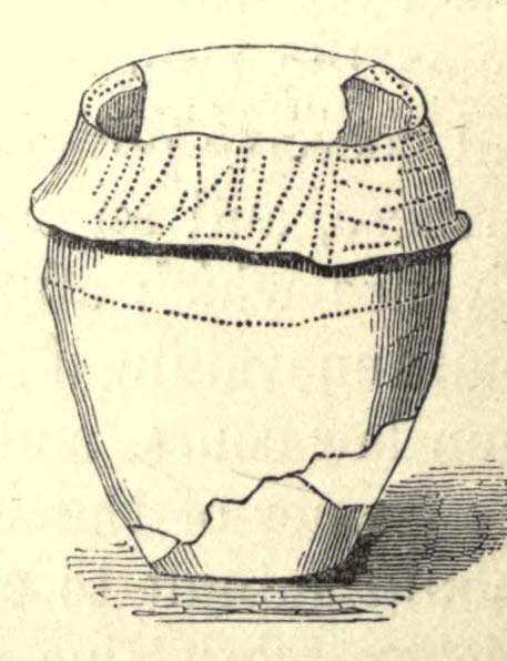
Urn found in one cist
“About the centre I found six deposits. The most northern of these was the skeleton of a young child, by the side of which, proceeding west, there was a cist containing a deposit of ashes and burnt bones; and near it another, rather above the floor, containing burnt wood. Immediately beneath this was a cist containing an urn, placed with its mouth downwards, and filled with burnt bones, which were perfectly dry and white. It was without any ornament, and measured in height ten and a quarter inches; the diameter at the mouth, which turned outwards, was eight and three-quarter inches, and at the bottom four inches. The other cists contained burnt bones and ashes. Sandstones had been placed over them, but were removed without my having an opportunity of ascertaining their position. A short distance south of these deposits there was a cist containing the bones and skull of a young child, over which had been placed a flat sandstone, and about a foot from it appeared a deposit of small bones, occupying a space of only two feet ; these were apparently the remains of a woman. Immediately above was a row of sandstones, resting, as was usual throughout the barrow, upon a thin layer of burnt wood. At this spot the barrow appeared to have been opened after its final formation, as if for the purpose of a subsequent interment, and filled up, not with the earth of which the remainder was formed, but with loose chalk, there being no stones or flints above those which lay immediately upon the deposit. At the extreme south of these cists was a large sandstone, three feet in diameter by sixteen inches in thickness, placed edgeways. The above-mentioned cists were circular.
Upright urn outside of cists
“A few inches west of the cist described as containing an urn, was the lower half of another, measuring in diameter five and a half inches, inverted, and placed upon the floor of the barrow, without any protection, merely surrounded by a thin layer of ashes and then the solid earth. It was filled with ashes and burnt bones, and rested upon the parts of a broken skull. Near this was an urn, also unprotected, and consequently much injured by the spade. It was placed upright, and measured in diameter nine and a half inches, by about ten inches in height. In form it resembled the urn first described, marked with impressed dots, but it was without any ornament. A short distance from these was a deposit of burnt wood at the west side of a large flat stone, placed edgeways, which measured three feet four inches by two feet ten inches, and thirteen inches in thickness. From its appearance it would seem that the fire had been lighted by its side. Immediately beneath the edge of this cist, and resting upon the chalk, was a small urn inverted, and by its side some small human bones. It was wholly unprotected, and unfortunately destroyed. South-east of this was a cist sixteen by twelve inches in diameter, and eighteen inches in depth, containing ashes and a few burnt bones, with a large-sized human tooth. Close to the edge of this cist, upon its western side, was placed in an upright position, a large stone measuring in diameter three by two and a half feet; and leaning against it another of still larger dimensions, inclining towards the north. This measured six and a half by four feet, and fifteen inches in thickness. About three feet further east were two large stones set edgeways, and meeting at their tops. Beneath them was the skeleton of a small child with the legs drawn up, lying from west to east. At the north-west side of the barrow, about five feet within the wall, was a cist cut in the solid chalk, measuring sixteen inches in diameter by sixteen in depth; it contained an urn inverted, and filled with burnt bones. Though carefully bandaged, it fell to pieces upon removal, being of more brittle material than any previously discovered. The clay of which it is formed is mixed with a quantity of very small white particles, having the appearance of pounded quartz. It measured in height nine inches by nine and a half in diameter, and is ornamented by six rows of circular impressions made with the end of a round stick or bone of a quarter of an inch in diameter. The cist was filled up with ashes.
Small cup-like urn
“A few inches from this was a cist differing in form, being wider at the top than beneath, in diameter eighteen inches by eighteen in depth; a flat stone was placed over it. It contained the skeleton of a young child, laid across, with the legs bent downwards. Lying close to the ribs was a small elegantly-shaped urn, measuring four inches in height by four in diameter, and made of rather a dark clay. It is ornamented with a row of small circular impressions, similar to those mentioned in the last instance, close to the lip, which turns rather out: beneath is a row of perpendicular scratches, and then two rows of chevrons, also perpendicular. At the feet of the skeleton was a peculiarly small cup, measuring in height one and a half inches by two and a quarter in diameter. It is ornamented with two rows of pricked holes near the top, beneath which is a row of impressions, made probably with an instrument of flat bone, three-eighths of an inch in width, slightly grooved across the end. The same pattern is at the bottom and upon the rim.
Another cup-like vessel
“Near this, towards the south-west, was a deposit of burnt wood, situated above the floor of the barrow, and immediately beneath it were two cists. In one of these, which measured two feet in diameter by one and a half in depth, were a few unburnt bones and several pieces of broken pottery, with a small cup, ornamented with three rows of the zigzag pattern, betwixt each of which, as well as upon the edge, is a row of pricked holes, and at the bottom a row of scratches. It measured in height two and a half inches by three in diameter, and had two small handles pierced horizontally: there appeared to have been originally four. In the other, which measured two feet in diameter by one in depth, were a few unburnt bones and a small urn placed with the mouth upwards, measuring four and three-quarter inches in height by the same in diameter. The lip, which turned very much out, is ornamented with a row of scratches, both within and upon its edge, a similar row also passes round near its centre. Close upon the edge of this cist was another urn of similar dimensions, inverted, and embedded in the solid earth without any protection. It is of much ruder workmanship than any of the others, and wholly unornamented, measuring five inches in height by five in diameter. Both these urns inclined equally towards the south-east. These last cists were partly, if not quite, surrounded by large sandstones set edgeways, and smaller ones built upon them, forming as it would seem a dome over the interments, filled with earth, and reaching to the surface of the barrow, where these stones have been occasionally ploughed out. From this circumstance, as well as the general appearance of the excavation, added to the description given by the labourer of the other part of the barrow, I am induced to suspect such to have been the case throughout… I found many pieces of broken pottery, and a part of a highly-ornamented urn. There was a total absence of any kind of arms or ornaments. The labourer however shewed me a round piece of thin brass, which he had found amongst the flints within the wall, measuring an inch and five-eighths in diameter. It had two minute holes near the circumference. It was probably attached to some part of the dress as an ornament. Teeth of horses and sheep were of frequent occurrence; I also found some large vertebrae and the tusk of a boar. Upon one of the large stones was a quantity of a white substance like cement, of so hard a nature that it was with difficulty I could break off a portion with an iron bar.
“If I offered a conjecture upon its formation, I should say that the wall, and foot of the barrow, which is of chalk, were first made, and the area kept as a family burying-place. The interments, as above described, were placed at different intervals of time, covered with earth (not chalk) or flints, and protected by stones. And over the whole, at a later period, the barrow itself was probably formed. My reason for this opinion is, first, that all these deposits, including, as they do, the skeletons of three or four infants, could scarcely have been made at the same time. And in the second place there was not the slightest appearance (with one exception) of displacement of the stones or flints in any way. As these circumstances then would suggest that the interments were formed at various periods, so the general appearance leaves no doubt as to the superstructure of flints, and surface or form of the barrow itself having been made at the same time and not piecemeal.
“I have met with no instance of a British barrow containing any appearance of a wall having surrounded the interments. Pausanias, in speaking of a monument of Auge, the daughter of Aleus king of Arcadia, in Pergamus, which is above the river Caicus, says, ‘ this tomb is a heap of earth surrounded with a wall of stone.’ And in the Saxon poem, ‘Beowulf,’ mention is made of a similar wall as surrounding the tomb of a warrior.”
One of the stones inside here was later found to possess “carvings of five cupmarks, two bronze daggers and two flat, triangular axes of early Breton type,” (Burl 1987) which Austen didn’t seem to notice at the time of his investigation. A profile of the Badbury Barrow carving can be found here.
Folklore
In Peter Knight’s (1996) survey of megalithic sites around Dorset, he includes the Badbury Barrow along a ley line that begins at the tumulus just below (south) Buzbury Rings and then travels ESE for about 5 miles until ending at another tumulus at ST 006 996.
References:
Austen, John H., “Archaeological Intelligence,” in Archaeological Journal, volume 3, 1846.
Burl, Aubrey, The Stonehenge People, Guild: London 1987.
Grinsell, Leslie V., Dorset Barrows, Dorset Natural History & Archaeological Society 1959.
Knight, Peter, Ancient Stones of Dorset, Power: Ferndown 1996.
Piggott, Stuart, “The Badbury Barrow, Dorset, and its Carved Stone,” in The Antiquaries, volume 19, 1939.
Royal Commission on Historical Monuments, England, An Inventory of the Historical Monuments in the County of Dorset – Volume 5: East Dorset, HMSO: London 1975.
Stone, J.F.S., Wessex Before the Celts, Thames & Hudson: London 1958.
Warne, Charles, The Celtic Tumuli of Dorset, John Russell Smith: London 1866.
Although ascribed as a wooden ‘henge’ by archaeologist Jean Cook, the site is more accurately a simple timber circle. Cook (1985) described this little-known “Wood Henge” monument, as she called it, sat inside the lower southeastern end of the impressive Dorchester Cursus monument. The site was obviously of some ritual importance, for a variety of reasons. It was excavated in 1981 and,
“it consisted of a ring of large pits enclosing an area some 18m in diameter. The site was situated along the central axis of the (Dorchester) cursus, presumably influenced by the alignment. The pits, which varied in size, had each contained a wooden post, in three instances consisting of an entire trunk of an oak tree. All the posts were burnt in situ, presumably during some form of destruction ceremony.”
Groundplan of site
When Alex Gibson came here a few years afterwards to re-examine the site, his work and that of Richard Bradley (1988) also found the place to have been an elliptical ‘ring’ of once-upright timber posts. Although Gibson (1998) later gave a confused version of where the site actually was (wrong grid-refs), his brief description gave us an outline of what was once here:
“An oval of 12 postholes containing the carbonized remains of 13 posts which had been burnt prior to the placing of cremations in the upper fills of the postholes. The SW posthole contained the remains of two posts in the same socket. There is a possible entranceway, marked by a wider gap between posts, in the NW.”
But this last line appears to be pure speculation. I’ve not read the longer archaeological accounts of this ‘wood henge’ and adjacent sites (Bradley & Chambers, 1988; Gibson 1992), which should give greater details about the site as a whole. The Pastscape site gives the following information:
“A pit circle comprising a sub-circular arrangement of 12 pits was excavated in the early 1980s in advance of work on the Dorchester by-pass. The site lay within the Dorchester Cursus (SU 59 NE 5), circa 400 metres northwest of its southeastern terminal. The long axis of the pit circle was the same as that of the cursus. Each of the pits had held a timber upright, and some if not all had been burnt in situ. An air photograph of the site had suggested the presence of a central pit but this feature proved to be a natural pocket of sand. Six deposits of cremated bone came from various post pipes. Other finds included a handful of potsherds, one possibly of Early Bronze Age date, some animal bone fragments, and a few flints. Radiocarbon dates from cremated bone and charcoal centred on the mid 3rd millennium BC, with one slightly later.”
References:
Bradley, R. & Chambers, R., “A New Study of the Cursus Complex at Dorchester-on-Thames, in Oxford Journal of Archaeology, volume 7, 1988.
Cook, Jean, “The Earliest Evidence,” in Dorchester through the Ages, Oxford University 1985.
Cook, Jean & Rowley, Trevor (eds.), Dorchester through the Ages, Oxford University 1985.
Gibson, Alex, “Possible Timber Circles at Dorchester-on-Thames,” in Oxford Journal of Archaeology, volume 11, 1992.
Gibson, Alex, Stonehenge and Timber Circles, Tempus: Stroud 1998.
Pennick, Nigel & Devereux, Paul, Lines on the Landscape, Hale: London 1989.
Bittova journey this — but well worth it! From Broughton-in-Furness take the A595 road west, past Duddon Bridge for about another 1½ miles, turning right up the small single-track country lane beloved of city-mind drivers, up the fertile scruffy road, past Broadgate and stopping just before Cragg Hall Farm. There’s a dirt-track running up the back of Cragg Hall. Go up here and keep walking for a mile or so until, as you approach Swinside Farm and the fields open up in front of you, the stones begin to appear.
Archaeology & History
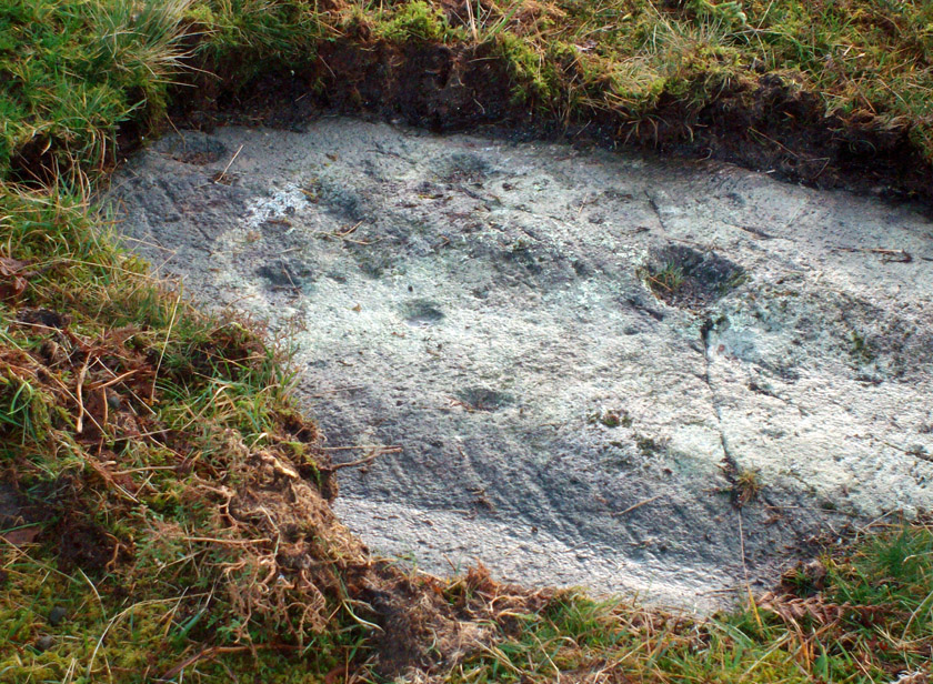
Swinside, looking east
The Swinside stone circle is Aubrey Burl’s favourite. And for good reason! Like other impressive megalithic rings of the region, the stones are large, well set, and the landscape holds the stones finely in the hills. Without the landscape here, Swinside (like Castlerigg and elsewhere) would not have such grandeur. When you sit in the ring, or walk round it, Knott Hill to the south was of obvious mythic relevance to the people who built this stone circle four or five thousand years ago. But this can be said of many of the surrounding crags. A few miles southwest we see the top of the haunted Black Combe rising into clouds, still speaking to some with spirits from animistic realms, long known to our ancestors. Following the skyline west and past the small falls of Whicham stream, whose name speaks of long past trees, we reach the near-west skyline with the cairn-looking pap of the Raven Crag, symptomatic of magickal rites calling to and beyond the circle. To the north is the symbolic ridge of Lath Rigg. Along the craggy eastern ridges from here you get the impression that you’re more in Argyll than Cumbria; and the break in the hills to the southeast reaches to the distant pinnacle of Kirkby Moor, where the midwinter sunrise emerged to tell of solar calendrical motions and the coming of the dark season to our megalithic tribes. But enough of the landscape!
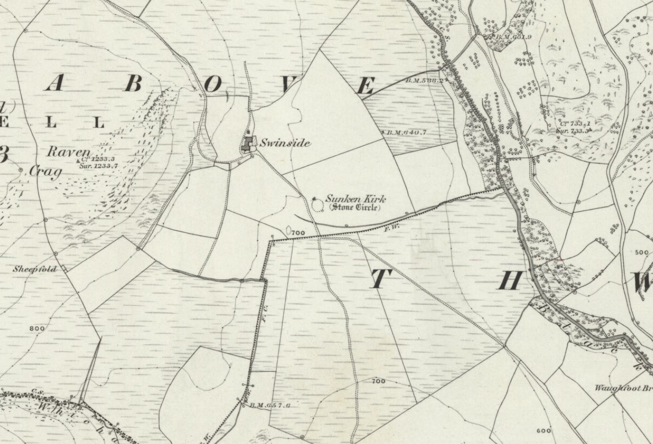
Swinside on 1867 OS-map
Although the name Swinside can be traced back to the 13th century, the local folk-name of the circle—Sunken Kirk—was mentioned for the first time as “the Chapell Suke” in Parish Registers of 1624. No earlier literary source has yet been identified, probably because of the isolation of the site and the lack of people writing about the area. Swinside stone circle is, just about, a perfect circle, give or take a foot here and there, holding the circular dome of the heavens within its domain. Yet despite its almost regal appearance, early references to the site seem scant. It seems to have been first described in William Hutchinson’s huge History of Cumberland (1794), where he told:
“In the neighbourhood of Millum, at a place called Swinside, in the estate of William Lewthwaite Esq., of Whitehaven, is a small but beautiful druidical monument; it is circular, about twenty eight yards in diameter; the stones of which it is composed are from six to eight feet high, all standing and complete. A little to the south, is another of larger dimensions, but not in so perfect a state: the neighbouring people call those places by the emphatical names of Sunken Kirks.”
A few years later, William Camden’s legendary text Britannia was edited and reprinted again, this time by Richard Gough (1806), who told:
“At Swineshead, a very high hill…is a druidical temple, which the country folk call Sunken Kirk, i.e., a church sunk into the Earth. It is nearly a circle of very large stones, pretty entire. No situation could be more agreeable to the Druids than this; mountains almost encircle it, not a tree is to be seen in the neighbourhood, nor a house, except a shepherd’s cot at the foot of a mountain surrounded by a few barren pastures. At the entrance are four large stones, two placed on each side at the distance of six feet. The largest on the left hand side is five feet six inches in height, and ten feet in circumference. Through this you enter into a circular area, 29 yards by 30. This entrance is nearly southeast. On the north or right-hand side is a huge stone of conical form, in height nearly nine feet. Opposite the entrance is another large stone which has once been erect, but is now fallen within the area: its length is eight feet. The left hand or southwest is one, in height seven feet, in circumference 11 feet nine inches. The altar probably stood in the middle, as there are some stones still to be seen, though sunk deep in the earth. The circle is nearly complete, except on the western side some stones are wanting. The largest stones are about thirty one or two in number. The outwards part of the circle upon the sloping ground is surrounded with a buttress or rude pavement of smaller stones raised about half a yard from the surface of the Earth… This monument of antiquity, when viewed within the circle, strikes you with astonishment, how the massy stones could be placed in such regular order either by human strength or mechanical power.”
Tall, northernmost stone to centreNortheast section of the ring
It seems he was impressed! Yet despite this, in the 19th century not many folk strayed this far into the western edges of Lakeland to look upon Swinside. There were occasional descriptions from travellers and antiquarians such as J.T. Blight (1843) and Edwin Waugh (1861), each speaking of the site’s visual magnitude, but it wasn’t until archaeologist C.W. Dymond came here, first in 1872 and then again in 1877, that a fuller account of the site came into being. In his essay on a “Group of Cumberland Megaliths,” he said how the stones were still in excellent condition and that,
“few of the stones seem to have been removed — probably because plenty of material for walling and road-making could be collected from the neighbouring hillside.” (Dymond 1881)
When Mr Dymond first came here he told of the remains of a rowan tree which had split one of the stones, but this has long gone. More than twenty years after the archaeologist’s first visit, he returned with R.G. Collingwood to make a more detailed evaluation of the ring. He measured and planned Swinside like it had never been done before and his ground-plan (below) is still very accurate indeed. Aubrey Burl (1999) takes up the story:
“The ring was partly excavated by Dymond, Collingwood and three men from midday Tuesday, 26 March 1901, until the close of the following evening. They dug two long, intersecting 46cm-wide trenches, NW-SE, NE-SW, across the ring with a curious zigzagging pattern of others between southeast and southwest: an investigation of some 51m² of the central area. Within the circle the trenches represented less than a thirteenth of the 642m² of the interior.
“Below the grass and turf was a thin layer of soil under which yellowish marl or ‘pinnel’ varied from 15cm to 75cm in depth, being deepest at the entrance which had been dug into earlier around 1850. Wherever it was uncovered the gravelly marl was wavily uneven, presumably the result of ploughing. The bases of the circle-stones rested on the pinnel, held firmly in their holes by small cobbles with others heavily packed around the sides. The only finds were a nut-sized lump of charcoal just northeast of the centre with others near the entrance; a minute splinter of decayed bone near the first bit of charcoal and two pieces of red stone. There were also some contemporary glass sherds and a Lancaster halfpenny dated between 1789 and 1794 lying in the uppermost turf layer.”
Dymond’s 1881 plan of Swinside
Since these early archaeological digs, Swinside has given up little else. Much like other stone circles in the British Isles, few real clues as to exactly what went on here have been forthcoming. But in the 1960s, investigations into megalithic sites made a bit of a quantum leap and some old ideas about astronomical ingredients were resurrected.
Alexander Thom’s plan of Swinside
Swinside was one of the places explored by engineer and megalith enthusiast, Alexander Thom. Thom was one of the prime figures instrumental in the resurgence of interest in megalithic sites — and his finds of megalithic astronomy and prehistoric mathematics had a lot to do with it. Although we know today that some of Thom’s work isn’t correct, his explorations and research stand him far ahead of most archaeologists who pretended to represent this area of research. He left us with the most detailed ground-plans of megalithic sites to date and, of course, showed some fascinating alignments.
Thom listed Swinside as site “L1/3” and made the most detailed and accurate ground-plan of this and 18 other megalithic rings in Cumbria. He found it to be 94 feet in diameter, with an internal area measuring 6940 square feet. The one major alignment Thom found at Swinside was of the winter solstice sunrise, lining up just on the edge of the ‘entrance’ to the circle’s southeastern side.
Folklore
Like a number of other stone circles, folklore told that you couldn’t count the stones. Janet and Colin Bord (1997) also told that people once tried to build a church here in early christian days, but once the builders went home in the evening, the Devil pulled down what they’d built during the day. A motif found at Ilkley’s Hanging Stones cup-and-ring carvings and many other prehistoric sacred sites in the country.
References:
Armstrong, A.M. et al., The Place-Names of Cumberland – volume 2, Cambridge University Press 1950.
Bord, Janet & Colin, Prehistoric Britain from the Air, Weidenfeld & Nicolson: London 1999.
Burl, Aubrey, “‘Without Sharp North…’ – Alexander Thom and the Great Stone Circle of Cumbria”, in Ruggles, Clive, Records in Stone, Cambridge University Press, 1988.
Burl, Aubrey, A Guide to the Stone Circles of Britain, Ireland and Brittany, New Haven & London 1995.
Burl, Aubrey, Great Stone Circles, Yale University Press: New York & London 1999.
Burl, Aubrey, The Stone Circles of Britain, Ireland and Brittany, Yale University Press 2000.
Dymond, C.W., “A Group of Cumberland Megaliths,” in Transactions of the Cumberland and Westmorland Antiquarian and Archaeological Society, volume 5, 1881.
Dymond, C.W., “An exploration at the Megalithic Circle called Sunken Kirk at Swinside, in the Parish of Millom, Cumberland,” in Transactions of the Cumberland and Westmorland Antiquarian and Archaeological Society, New Series volume 2, 1902.
Gough, Richard (ed.), Camden’s Britannia, J. Nichols and Son: London 1806.
Hutchinson, William, The History of the County of Cumberland – volume 1, F. Jollie: Carlisle 1794.
Seton, Ray, The Reason for the Stone Circles in Cumbria, R. Seton: Morecambe 1995.
Thom, Alexander, Megalithic Sites in Britain, Oxford University Press 1967.
Thom, A., Thom, A.S. & Burl, H.A.W., Megalithic Rings, BAR: Oxford 1980.
Waterhouse, John, The Stone Circles of Cumbria, Phillimore: Chichester 1985.
Waugh, Edwin, Seaside Lakes and Mountains of Cumberland, Alexander Ireland: Manchester 1861.
ACKNOWLEDGEMENTS:
Huge thanks to Brian Else for his photos. And to Paul and Tricia for taking us here, in awesome downpour weather!
Cup-and-Ring Stone (lost): OS Grid Reference – SE 1015 4702
Also Known as:
Panorama Rock 226
Archaeology & History
J.R. Allen’s 1879 drawing
It would seem that this excellent looking cup-and-ring stone may have been destroyed sometime around 1890 during the construction of the Panorama Reservoir and the building of the houses on the southwestern edge of Ilkley, right by the moorside. But this isn’t known for certain; and the carving could still exist beneath vegetation in the trees just north of the reservoir. In requesting to explore some National Archives data in which there may be information relating to this carving (and others nearby), I was directed to Bradford Council’s community archaeologist, Gavin Edwards (to whom requests should be made), but he denied access to look at the files, then completely ignored subsequent queries that might enable us to locate this and other important prehistoric carvings. So we did our best and this is what we’ve found so far (forgive any errors).
As there’s a slight ambiguity in the precise location of this lost carving, we cannot say for certain whether or not this site was included in the sale of Property Lots, numbers 7-34, “surrounding the far-famed Panorama Rocks,” which may have led to the site’s destruction and subsequent removal of the protected Panorama Stones to Saint Margaret’s Park on the other side of the road from the church, closer to Ilkley centre. The sale of this “building land” as it was called was advertised in the Leeds Mercury, Saturday September 4, 1880, with a brief description of the respective “lots” near this and the adjacent carvings. But this Panorama Stone 226 may have been left alone and be buried under the surface…
J.T. Dale’s 1880 sketch
Historical notes on this particular stone are scattered and sparse, but digging through old journals and texts has given us a reasonably good vision of the place. It was first described, albeit in passing, in A.W. Morant’s edited third edition of Whitaker’s History of Craven (1878: 289), where it was described in context with the other cup-and-ring east of here on the same ridge. All of them were described as being located within a now-destroyed prehistoric enclosure (precise nature unknown), with carving 226 at the westernmost end. However, the following year J. Romilly Allen (1879) gave more details of this, “the third stone” as he called it and furnished us with a damn good drawing to boot!
As we can see, there are four double-ringed cups and eight or nine archetypal cup-and-rings, with the usual scatter of cups falling across the design. The curious ‘ladder’ markings found on one of the other Panorama Stones, the Barmishaw Stone, Willy Hall’s Wood carving and at least one of the Baildon Moor carvings, were also quite prominent. Although when J. Thornton Dale visited here around the same time and did his own drawings, the ladders weren’t quite as pronounced. This would have been due to the simple factors of cloud cover, poorer sunlight and the time of day the drawings were done (the pseudoscientific proclamation of local archaeologist Gavin Edwards that such artistic difference is due to some Victorian chap adding, or removing sections of the carvings for his own pleasure, negates common sense and is strongly lacking in evidence). Romilly Allen’s own description of the site was as follows:
“The Panorama Rock lies one mile south-west of Ilkley, and from a height of 800 feet… About 100 yards to the west of this spot appears to be some kind of rough inclosure, formed of low walls of loose stones, and within it are the three finest sculptured stones near Ilkley. They lie almost in a straight line East to West… The third and most westerly stone of the group measures 10ft. by 9ft. and lies almost horizontally, having its face slightly inclined. On it are carved twenty-seven cups, fourteen of which have concentric rings round them. Some of the cups have connecting grooves, and three have the ladder-shaped pattern before referred to.”
Notes from a few years later told that this carving was still in situ when the companion carvings were moved and imprisoned behind railings across from St. Margaret’s Church in Ilkley. The carving was shown at the grid reference given above on the 1895 Ordnance Survey map of the region before the reservoir was built, correcting the coordinates given in Boughey & Vickerman’s (2003) otherwise fine survey. They described this very ornate carving thus:
“According to Thornton Dale (1880), this was a large rock with 27 cup, eighteen of which had single rings. Some of the cups had connecting grooves and three had the same ladder motif as the Panorama Stone.”
…to be continued…
References:
Allen, J. Romilly, “The Prehistoric Rock Sculptures of Ilkley,” in Journal of the British Archaeological Association, volume 35, 1879.
Allen, J. Romilly, “Notice of Sculptured Rocks near Ilkley,” in Journal of the British Archaeological Association, volume 38, 1882.
Allen, J. Romilly, “Cup and Ring Sculptures on Ilkley Moor,” in The Reliquary, volume 2, 1896.
Bennett, Paul, The Panorama Stones, Ilkley, TNA: Yorkshire 2012.
Boughey, Keith, “The Panorama Stones,” in Prehistory Research Section Bulletin, no.40, Yorkshire Archaeological Society: Leeds 2003.
Boughey, K.J.S. & Vickerman, E.A., Prehistoric Rock Art of the West Riding, WYAS: Leeds 2003.
Collyer, Robert & Turner, J.H., Ilkley: Ancient and Modern, William Walker: Otley 1885.
Jennings, Hargrove, Archaic Rock Inscriptions, A.Reader: London 1891.
Turner, J. Horsfall, “British or Prehistoric Remains,” in Collyer & Turner, Otley 1885.
Whitaker, Thomas Dunham, The History and Antiquities of the Deanery of Craven in the County of York, (3rd edition) Joseph Dodgson: Leeds 1878.


")
")
")
