Cross (destroyed): OS Grid Reference – SY 5167 9622
Archaeology & History
This old cross was almost lost to history, but thanks to personal notes written by one John Banger Russell in 1780, we’ve been left with a description of the monument, which Alfred Pope (1906) published in his survey:
“In the middle of this parish are the remains of a large cross, which has been much injured by time. The shaft, which seems to have been of considerable height, has been taken down, tho’ the base or pediment still continues in its proper place. The ascent was by four steps but the whole is very ruinous.”
Nearly a hundred years later in the hugely updated magnum opus of John Hutchins (1863), the site had long gone:
“A mutilated cross which stood in the centre of the village at the beginning of the present century, has since been destroyed.”
References:
Hutchins, John, The History and Antiquities of the County of Dorset – volume 2, Bowyer & Nichols: London (3rd edition) 1863.
Pope, Alfred, The Old Stone Crosses of Dorset, Chiswick Press: London 1906.
In days of olde an old stone cross used to stand “at the crossroads just outside the churchyard,” wrote Alfred Pope (1906); but even in his day he told that “the cross has long since disappeared.” He continued:
“The Rev A.S.B. Freer, vicar, informs the writer that the site is still known as ‘The Cross’, and is never called by any other name by the villagers.”
The church in the village is dedicated to All Saints, whose festival date was known in older times to be the pre-christian New Year’s Eve, or Halloween, when the spirits of the dead move across the landscape.
References:
Pope, Alfred, The Old Stone Crosses of Dorset, Chiswick Press: London 1906.
A number of very large prehistoric burial mounds, or tumuli, were destroyed in this part of Dorset in the 19th century, including “three on the Came estate, near Dorchester, the property of the Hon Col. Damer.” This one—listed as a “bowl barrow” and known today as the Winterborne Came 18b tumulus in Grinsell’s (1959:148) brilliant survey—was found to house examples of petroglyphs, which are very rare in this part of Britain. Thankfully before its destruction, the local antiquarian Charles Warne (1848) was present and has left us with a good description of its structure and contents. After first telling of the demise of two other large tumuli close by, the biggest of them drew his attention:
“The last of these mighty mounds (and well do they merit the appellation from their vastness), measured rather more than ninety feet in diameter, and sixteen feet in height; this from the peculiarity of its contents was the most interesting of the three. The annexed rough sketch (above), shewing a central section of the tumulus, may serve to give some idea of the singularity of its composition. About the centre, at a depth of some three feet from the surface, was found lying flat a rough unhewn stone, with a series of concentric circles incised; this, on being removed, was seen to have covered a mass of flints from six to seven feet in thickness, which being also removed we came to another unhewn irregular stone, with similar circles inscribed, and as in the preceding case, covering another cairn of flints, in quantity about the same as beneath the first stone. It was in this lower mass that the deposits were found, consisting of all the fragments of an urn of coarse fabric, and apparently as if placed in its situation without either care or attention, no arrangement of the flints being made (as we have elsewhere seen) for its protection; the want of which observance had completed its destruction. Under the flints, lying at the base, were the remains of six skeletons, and some few bones of the ox. The skeletons had apparently been placed without order or regularity: with the exception of a few bits of charcoal with the urn, there was no evidence of cremation.”
Nearly twenty years later, Sir James Simpson (1867) also described the tumulus and its carved rocks in his 19th century magnum opus, repeating much of Warne’s earlier description, saying:
“In his antiquarian researches in this county (Dorset), Mr Warne opened , at Came Down on the Ridgeway, a tumulus of rather unusual form. At its base…were found the remains of six unburnt human skeletons…and some few bones of the ox. Above them, and in the centre of the tumulus, was built up a cairn or heap of flints around a coarse and broken urn, which contained calcined bones. This mass of flints was surrounded and covered by a horizontal rough slab. Above and upon this slab was built another large heap of flints, six or seven feet in thickness. This second heap was capped with another rough slab, lying two or three feet below the surface of the tumulus. Both these flat unhewn covering slabs had a group of concentric circles cut upon them.”
We don’t know for sure the exact whereabouts of the tumulus, nor the age of the tomb and its remains. But the size of it may indicate an early Bronze Age and perhaps even neolithic status. The finding of the rock art in the tomb is also an indicator that could push the date back into late neolithic period—but we may never know for sure…
References:
Grinsell, Leslie V., Dorset Barrows, Dorset Natural History & Archaeological Society 1959.
Royal Commission on Historical Monuments (England), An Inventory of Historical Monuments in the County of Dorset – Volume 2: South-East, HMSO: London 1970.
Simpson, James, Archaic Sculpturings of Cups, Circles, etc., Upon Stones and Rocks in Scotland, England and other Countries, Edmonston & Douglas: Edinburgh 1867.
Warne, Charles, “Removal of Three of the Large Tumuli on the Came Estate, near Dorchester,” in Journal of the British Archaeological Association, volume 3, 1848.
Warne, Charles, The Celtic tumuli of Dorset: An Account of Personal and other Researches in the Sepulchral Mounds of the Durotriges, J.R. Smith: London 1866.
Standing Stones (destroyed): OS Grid Reference – SY 6070 8701
Also Known as:
Jefferey and Jone
Archaeology & History
Described in early field-name listings as ‘Jefferey and Jone’, this was another group of standing stones, whose precise nature is difficult to truly discern, that met with an untimely end in the middle of the 19th century. They may have been part of a large tomb, or even a stone circle. Marked on the early Ordnance Survey map of the area as ‘Standing Stones (site of)’, they appear to have been described firstly by John Hutchins (1774) close to other megalithic remains, who told that:
“A little north of Hell Stone near Blagdon are four upright stones, near to, and equally distant from each other, about two feet high, except that one is broken off even with the ground.”
In Warne’s (1866) classic text he mentioned these petrified monoliths,
“In a small valley, on the down of Portesham Farm, there stood within these last ten years, four upright stones… By the direction of the then occupier of the farm, Mr Manfield, these stones were built into an adjoining wall.”
A few years later another account by H.C. March, which referred to Mr Warne’s description, gave another report citing information from one who was present at the destruction of the site:
“Warne says they have been built into an adjacent wall: but a man who was present at the ceremony stated that, by the spot where they once stood, a hole was made for them, and they were decently interred. The place where they are said to lie can be pointed out, as well as a wall which contains four large stones.” (Harte 1986:54)
Historian and folklorist Jeremy Harte (1986) concluded that the megaliths must obviously have been destroyed around the year 1855. However, the historical references of Jeffrey & Jone being moved into the adjacent walling appears to be verified by independent researchers who’ve found standing stones hereby.
Folklore
Very probably the remains of petrified ancestors, a curious rhyme describes a forgotten folktale of these lost standing stones relating to them as possessing spirit, or once being alive. They were thought of once as being a family who lived in the hills:
“Jefferey and Jone,
And their little dog Denty
and Edy alone.”
Sadly, I can find nothing further that might enrich the folktales that were obviously once spoken of these monoliths.
References:
Harte, Jeremy, Cuckoo Pounds and Singing Barrows, Dorset Natural History & Archaeological Society 1986.
Hutchins, John, The History and Antiquities of Dorset, John Bowyer & J Nichols: London 1774.
Warne, Charles, The Celtic Tumuli of Dorset, John Russell Smith: London 1866.
A prehistoric round barrow with an ancient literary pedigree, dating back to Anglo-Saxon records according to A.D. Mills (1989), when is was described in the boundary records of 833 AD as ‘on burg‘. It was described again in local records as Buleberwe in 1270, then more like the form we recognize today as the Bulbarowe in 1545, and variants thereof many times since then.
Measuring about 18 yards across and standing four feet high, Grinsell (1959) defined the monument as a ‘Bowl Barrow’, due to the shape of the mound. A brief description of the site by the Royal Commission (1970) lads told:
“Bulbarrow (77500574), bowl, lies at about 870ft above sea-level near the summit of the chalk escarpment, here known as Bulbarrow Hill. The centre of the mound has been dug into. Diameter 54tf, height 4ft.”
Grinsell and the Royal Commission both made note of a “sharpened bone of deer”, reported by Mr Woolls (1839), but pointed out there was an uncertainty whether the bone was dug “from this or the Bull Barrow in Holt” parish.
All early forms of the burial mound’s name strongly suggest it derived to a once great bull. The reason for this cannot be known for certain, but if we follow Conrad (1959) or Eliade’s (1986) rationale, the animal here was very likely a sacred bull — akin to the more famous Bull of Minos, or Apis, or Nandi. The religious importance of sacred animals was just as widespread in the British Isles as it was elsewhere in the world (examples of bulls relating to prehistoric remains scatter the British Isles with a similar association: see the Bull Stone, Guiseley; the Creagantarbh stones and hillfort, Argyll, etc.). It would be good to know of any local folklore relating to oxen or other bovines in the Woolland area.
References:
Conrad, Jack Randolph, The Horn and the Sword: The History of the Bull as Symbol of Power and Fertililty, MacGibbon & Kee: London 1959.
Eliade, Mircea, Zalmoxis, University of Chicago Press 1986.
Grinsell, Leslie V., Dorset Barrows, Dorset Natural History & Archaeological Society 1959.
Mills, A.D., The Place-Names of Dorset – part 3, English Place-Name Society 1989.
Royal Commission on Historical Monuments (England), An Inventory of Historical Monuments in the County of Dorset – Volume 3: Central Dorset, Part 2, HMSO: London 1970.
Cup-and-Ring Stone: OS Grid Reference – SY 6800 8601
Also Known as:
Winterborne Came 18b Carving (Grinsell)
Archaeology & History
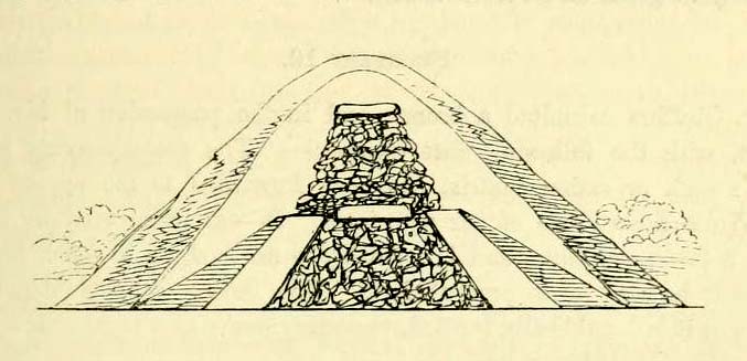
Charles Warne’s 1848 drawing of the old tumulus
On January 27, 1848, the great Dorsetshire antiquarian Charles Warne sent a letter to the British Archaeological Association about a series of three large tumuli he’d explored south of Dorchester in Dorset, within which he’d found some fascinating remains. And in what he called “the last of these mighty mounds (and well do they merit the appellation from their vastness),” which “measured rather more than ninety feet in diameter, and sixteen feet in height,” the most intriguing remains emerged. In the middle of what L.V. Grinsell (1959) catalogued as the Winterborne Came 18b tumulus, Mr Warne told:
“About the centre, at a depth of some three feet from the surface, was found lying flat a rough unhewn stone, with a series of concentric circles incised; this, on being removed, was seen to have covered a mass of flints from six to seven feet in thickness, which being also removed we came to another unhewn irregular stone, with similar circles inscribed, and as in the preceding case, covering another cairn of flints, in quantity about the same as beneath the first stone.”
“…It will be seen that the most singular feature connected with this tumulus, is that of the incised stones: examples of which I am not aware have before been met with in like situations. It may be as well to forego any attempt at an elucidation, which must be purely hypothetical; but it seems more reasonable to believe that they bore some mystic reference, rather than that they were the unmeaning amusement of some Celtic idler.”
One of 2 carved stones found in the tumulus
Sir James Simpson (1867) described these carved stones in his 19th century magnum opus, giving an early illustration of one of them, as shown here. You’ll note that the carving is devoid of any central ‘cup’ as commonly found, consisting simply of a mere series of concentric rings.
If anyone knows the whereabouts of this and its companion stone today, it would be good to see them. Are they kept in some local museum?
References:
Grinsell, Leslie V., Dorset Barrows, Dorset Natural History & Archaeological Society 1959.
Royal Commission on Historical Monuments (England), An Inventory of Historical Monuments in the County of Dorset – Volume 2: South-East, HMSO: London 1970.
Simpson, James, Archaic Sculpturings of Cups, Circles, etc., Upon Stones and Rocks in Scotland, England and other Countries, Edmonston & Douglas: Edinburgh 1867.
Warne, Charles, “Removal of Three of the Large Tumuli on the Came Estate, near Dorchester,” in Journal of the British Archaeological Association, volume 3, 1848.
Cup-Marked Stone: OS Grid Reference – ST 9583 0294
Also Known as
Badbury Rings Carving
Shapwick 6a carving
Archaeology & History
Badbury Barrow carving (after J.F.S. Stone 1958)
Amidst what was once a veritable gathering of prehistoric tombs on the ground immediately west of the Badbury Rings hillfort — a small necropolis no less! — one particular tumulus which Leslie Grinsell named as ‘Shapwick 6a‘ was in the process of being destroyed at the end of October, 1845, but was fortunate in receiving the quick attention of a local historian called John Austen, who gave us the first known account of the place. (a fuller profile of the Badbury Barrow can be found here) Inside the churned-up remains of Badbury Barrow, which measured 62 feet across and 9 feet high, Mr Austin found a fascinating number of urns and other remains and, shortly after, this rare example of a petroglyph was identified. The stone now lives in the British Museum where, the last I knew, you could certainly check it out. But it’s not its original size, as sections of the stone were broken off. As Aubrey Burl (1987) told us, the stone was originally about half-a-ton in weight, on which,
“were carvings of five cupmarks, two bronze daggers and two flat, triangular axes of early Breton type.”
Grinsell’s more detailed description of the carving from his work on Dorset Barrows (1959) tells a little more of the design found on this seeming ‘tomb-stone’:
“Sandstone slab, probably from stone cist, decorated with pecked carvings of two daggers with hilts, resembling those on stone 53 at Stonehenge; two triangular objects probably intended to be flat bronze axe-heads expanding at their cutting-edge; and five cup-shaped hollows. The existing decorated fragment (in British Museum) is 1ft 10in long, and was detached from the original slab which weighed probably more than half a ton. The size suggests, perhaps, a cover-slab.”
It may well have been. Certainly it had some relationship to death! The design was suggested in the 19th century to perhaps have been influenced by Greek imagery, when such notions were in vogue. As Grinsell tells,
“In the centre according to Durden…was the well-known large slab of sandstone which was decorated with carvings of daggers and axes, the former of type similar to those from Stonehenge, conjectured to be of Mycenean type.”
But the Mycenean nature of the carvings is highly unlikely. What is intriguing with this carving is the appearance of cup-markings (commonly associated in or adjacent to prehistoric tombs) alongside defined symbols of daggers. We could infer a magickal relationship between the two symbols here: one of which, the cups, comes from a much earlier period than the dagger-design. A more in-depth analysis of the human remains within the tumulus and a plan of the site would perhaps be more revealing…
…to be continued…
References:
Austen, John H., “Archaeological Intelligence,” in Archaeological Journal, volume 3, 1846.
Burl, Aubrey, The Stonehenge People, Guild: London 1987.
Grinsell, Leslie V., Dorset Barrows, Dorset Natural History & Archaeological Society 1959.
Knight, Peter, Ancient Stones of Dorset, Power: Ferndown 1996.
Royal Commission on Historical Monuments, England, An Inventory of the Historical Monuments in the County of Dorset – Volume 5: East Dorset, HMSO: London 1975.
Stone, J.F.S., Wessex Before the Celts, Thames & Hudson: London 1958.
Warne, Charles, The Celtic Tumuli of Dorset, John Russell Smith: London 1866.
Of at least 26 prehistoric barrows or tumuli in close proximity on the grasslands immediately west of the Badbury hillfort, this particular ‘Badbury Barrow’ as it’s generally called, was the most intriguing of the bunch. Intriguing as it was found to possess a very rare carved stone near its centre, and had the elements of the dead laid out in a quite fascinating manner, with a large inner wall that surrounded the dead. Grinsell (1959) posited that this site may be the same one described on the 1826 Greenwood Map of the region as the ‘Straw Barrow’ – in which case I’d love to know if there are earlier place-name references to the site and see what its name is thought to mean. (Mills’ PNs Dorset, 2, could be helpful – though it could be just ‘straw’!) However, the Straw Barrow is some distance to the west of here.
The first lengthy description of the site was done very soon after the near destruction of the place in 1845. A local man called John Austen visited and described the old tumulus in some considerable detail, and I make no apologies for adding his complete description of the barrow, as he found it, just before the land-owner levelled the place. He wrote:
“On Nov. 1, 1845, I accidentally ascertained that a barrow situated about five miles from Wimborne, Dorset, upon the road leading to Blandford, and in the immediate neighbourhood of Badbury camp, was in progress of being levelled. The circumstance which chiefly attracted my notice was the vast quantities of large sandstones and flints which had been taken from it. Unfortunately nearly two-thirds of the tumulus were already removed. From the remainder, however, I have obtained a tolerably accurate idea of its interior arrangement, which, with perhaps the exception of the ‘Deverill barrow’, opened by W. Miles, Esq., in 1825, is more highly interesting than any yet examined. The labourer employed could give me but little information respecting the part already destroyed, further than that he had thrown up many pieces of pottery, and found one urn in a perfect state, but in removal he had broken it; sufficient however remained to enable me to ascertain its form and dimensions. It measured 8 inches in height, 6¾ inches at the mouth, and at the bottom 3½ inches. The colour of the outer side was more red than is usual, and within it had a black hard ash adhering to the side, It was inverted, and contained only a few white ashes. It was ornamented with lines of from nine to fourteen fine pricked dots, as if made with a portion of a small tooth comb. Such an instrument was discovered a few years since by some workmen, whilst lowering a hill midway betwixt Badbury camp and the village of Shapwicke, having at one end a small circular hole, and at the other eight short teeth like those of a comb. It was four inches long and one inch wide, and was part of the rib of a deer…
“The barrow was circular, measuring about eighty yards in circumference, the diameter sixty-two feet, and the height nine feet; it had however been considerably reduced by the plough. Upon clearing a section across the centre, the following formation presented itself. The outside circle or foot of the barrow was of chalk, occupying a space of fifteen feet towards the centre. There was then a wall extending completely round, and enclosing an area of about thirty feet in diameter, composed of large masses of sandstone brought from some part of the heath, probably from Lytchett, a distance of not less than five miles, and across the river Stour. These stones were well packed together as in the foundations of a building, and the interstices tightly filled with flints. Within this wall, for the space of three or four feet, was a bed of flints, without any mixture of earth or chalk, packed together from the floor to the surface of the barrow, having only a few inches of earth above. The remainder of the interior was occupied by large sandstones, serving to protect the various interments.
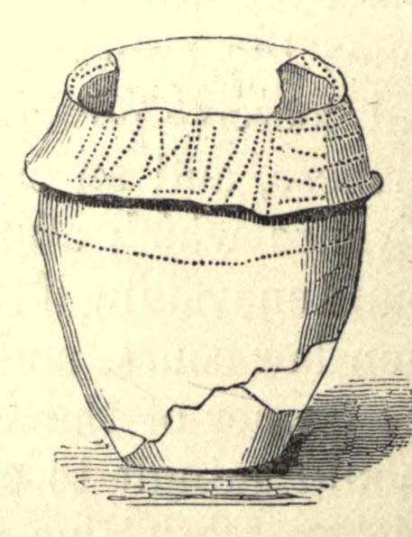
Urn found in one cist
“About the centre I found six deposits. The most northern of these was the skeleton of a young child, by the side of which, proceeding west, there was a cist containing a deposit of ashes and burnt bones; and near it another, rather above the floor, containing burnt wood. Immediately beneath this was a cist containing an urn, placed with its mouth downwards, and filled with burnt bones, which were perfectly dry and white. It was without any ornament, and measured in height ten and a quarter inches; the diameter at the mouth, which turned outwards, was eight and three-quarter inches, and at the bottom four inches. The other cists contained burnt bones and ashes. Sandstones had been placed over them, but were removed without my having an opportunity of ascertaining their position. A short distance south of these deposits there was a cist containing the bones and skull of a young child, over which had been placed a flat sandstone, and about a foot from it appeared a deposit of small bones, occupying a space of only two feet ; these were apparently the remains of a woman. Immediately above was a row of sandstones, resting, as was usual throughout the barrow, upon a thin layer of burnt wood. At this spot the barrow appeared to have been opened after its final formation, as if for the purpose of a subsequent interment, and filled up, not with the earth of which the remainder was formed, but with loose chalk, there being no stones or flints above those which lay immediately upon the deposit. At the extreme south of these cists was a large sandstone, three feet in diameter by sixteen inches in thickness, placed edgeways. The above-mentioned cists were circular.
Upright urn outside of cists
“A few inches west of the cist described as containing an urn, was the lower half of another, measuring in diameter five and a half inches, inverted, and placed upon the floor of the barrow, without any protection, merely surrounded by a thin layer of ashes and then the solid earth. It was filled with ashes and burnt bones, and rested upon the parts of a broken skull. Near this was an urn, also unprotected, and consequently much injured by the spade. It was placed upright, and measured in diameter nine and a half inches, by about ten inches in height. In form it resembled the urn first described, marked with impressed dots, but it was without any ornament. A short distance from these was a deposit of burnt wood at the west side of a large flat stone, placed edgeways, which measured three feet four inches by two feet ten inches, and thirteen inches in thickness. From its appearance it would seem that the fire had been lighted by its side. Immediately beneath the edge of this cist, and resting upon the chalk, was a small urn inverted, and by its side some small human bones. It was wholly unprotected, and unfortunately destroyed. South-east of this was a cist sixteen by twelve inches in diameter, and eighteen inches in depth, containing ashes and a few burnt bones, with a large-sized human tooth. Close to the edge of this cist, upon its western side, was placed in an upright position, a large stone measuring in diameter three by two and a half feet; and leaning against it another of still larger dimensions, inclining towards the north. This measured six and a half by four feet, and fifteen inches in thickness. About three feet further east were two large stones set edgeways, and meeting at their tops. Beneath them was the skeleton of a small child with the legs drawn up, lying from west to east. At the north-west side of the barrow, about five feet within the wall, was a cist cut in the solid chalk, measuring sixteen inches in diameter by sixteen in depth; it contained an urn inverted, and filled with burnt bones. Though carefully bandaged, it fell to pieces upon removal, being of more brittle material than any previously discovered. The clay of which it is formed is mixed with a quantity of very small white particles, having the appearance of pounded quartz. It measured in height nine inches by nine and a half in diameter, and is ornamented by six rows of circular impressions made with the end of a round stick or bone of a quarter of an inch in diameter. The cist was filled up with ashes.
Small cup-like urn
“A few inches from this was a cist differing in form, being wider at the top than beneath, in diameter eighteen inches by eighteen in depth; a flat stone was placed over it. It contained the skeleton of a young child, laid across, with the legs bent downwards. Lying close to the ribs was a small elegantly-shaped urn, measuring four inches in height by four in diameter, and made of rather a dark clay. It is ornamented with a row of small circular impressions, similar to those mentioned in the last instance, close to the lip, which turns rather out: beneath is a row of perpendicular scratches, and then two rows of chevrons, also perpendicular. At the feet of the skeleton was a peculiarly small cup, measuring in height one and a half inches by two and a quarter in diameter. It is ornamented with two rows of pricked holes near the top, beneath which is a row of impressions, made probably with an instrument of flat bone, three-eighths of an inch in width, slightly grooved across the end. The same pattern is at the bottom and upon the rim.
Another cup-like vessel
“Near this, towards the south-west, was a deposit of burnt wood, situated above the floor of the barrow, and immediately beneath it were two cists. In one of these, which measured two feet in diameter by one and a half in depth, were a few unburnt bones and several pieces of broken pottery, with a small cup, ornamented with three rows of the zigzag pattern, betwixt each of which, as well as upon the edge, is a row of pricked holes, and at the bottom a row of scratches. It measured in height two and a half inches by three in diameter, and had two small handles pierced horizontally: there appeared to have been originally four. In the other, which measured two feet in diameter by one in depth, were a few unburnt bones and a small urn placed with the mouth upwards, measuring four and three-quarter inches in height by the same in diameter. The lip, which turned very much out, is ornamented with a row of scratches, both within and upon its edge, a similar row also passes round near its centre. Close upon the edge of this cist was another urn of similar dimensions, inverted, and embedded in the solid earth without any protection. It is of much ruder workmanship than any of the others, and wholly unornamented, measuring five inches in height by five in diameter. Both these urns inclined equally towards the south-east. These last cists were partly, if not quite, surrounded by large sandstones set edgeways, and smaller ones built upon them, forming as it would seem a dome over the interments, filled with earth, and reaching to the surface of the barrow, where these stones have been occasionally ploughed out. From this circumstance, as well as the general appearance of the excavation, added to the description given by the labourer of the other part of the barrow, I am induced to suspect such to have been the case throughout… I found many pieces of broken pottery, and a part of a highly-ornamented urn. There was a total absence of any kind of arms or ornaments. The labourer however shewed me a round piece of thin brass, which he had found amongst the flints within the wall, measuring an inch and five-eighths in diameter. It had two minute holes near the circumference. It was probably attached to some part of the dress as an ornament. Teeth of horses and sheep were of frequent occurrence; I also found some large vertebrae and the tusk of a boar. Upon one of the large stones was a quantity of a white substance like cement, of so hard a nature that it was with difficulty I could break off a portion with an iron bar.
“If I offered a conjecture upon its formation, I should say that the wall, and foot of the barrow, which is of chalk, were first made, and the area kept as a family burying-place. The interments, as above described, were placed at different intervals of time, covered with earth (not chalk) or flints, and protected by stones. And over the whole, at a later period, the barrow itself was probably formed. My reason for this opinion is, first, that all these deposits, including, as they do, the skeletons of three or four infants, could scarcely have been made at the same time. And in the second place there was not the slightest appearance (with one exception) of displacement of the stones or flints in any way. As these circumstances then would suggest that the interments were formed at various periods, so the general appearance leaves no doubt as to the superstructure of flints, and surface or form of the barrow itself having been made at the same time and not piecemeal.
“I have met with no instance of a British barrow containing any appearance of a wall having surrounded the interments. Pausanias, in speaking of a monument of Auge, the daughter of Aleus king of Arcadia, in Pergamus, which is above the river Caicus, says, ‘ this tomb is a heap of earth surrounded with a wall of stone.’ And in the Saxon poem, ‘Beowulf,’ mention is made of a similar wall as surrounding the tomb of a warrior.”
One of the stones inside here was later found to possess “carvings of five cupmarks, two bronze daggers and two flat, triangular axes of early Breton type,” (Burl 1987) which Austen didn’t seem to notice at the time of his investigation. A profile of the Badbury Barrow carving can be found here.
Folklore
In Peter Knight’s (1996) survey of megalithic sites around Dorset, he includes the Badbury Barrow along a ley line that begins at the tumulus just below (south) Buzbury Rings and then travels ESE for about 5 miles until ending at another tumulus at ST 006 996.
References:
Austen, John H., “Archaeological Intelligence,” in Archaeological Journal, volume 3, 1846.
Burl, Aubrey, The Stonehenge People, Guild: London 1987.
Grinsell, Leslie V., Dorset Barrows, Dorset Natural History & Archaeological Society 1959.
Knight, Peter, Ancient Stones of Dorset, Power: Ferndown 1996.
Piggott, Stuart, “The Badbury Barrow, Dorset, and its Carved Stone,” in The Antiquaries, volume 19, 1939.
Royal Commission on Historical Monuments, England, An Inventory of the Historical Monuments in the County of Dorset – Volume 5: East Dorset, HMSO: London 1975.
Stone, J.F.S., Wessex Before the Celts, Thames & Hudson: London 1958.
Warne, Charles, The Celtic Tumuli of Dorset, John Russell Smith: London 1866.
Crowned by a clump of trees (planted in 1740), this hilltop site is one of the more impressive of a number of tombs hereby, with its nearest other neighbour being 70 yards southeast of here. One of Dorset’s early tribal meeting places (Anderson 1934), the tomb was illustrated on Isaac Taylor’s 1765 map of the region and was dug into in 1858 “on the orders of a local magnate” (Marsden 1999), damaging some substantial portion of the tomb. Of this, craniologist and antiquarian John Thurnam was most displeased; for in his description of the opening of Culliford Tree he wrote:
“A wide trench had been dug through it one side, from the summit and the rubble which had been thrown out had not been replaced… Another subject of regret was the fact that though, as we were told by the neighbouring rustics, human remains, with pottery and certain other relics, were found in the barrow, no authentic account of the exploration had, so far as we could learn, been put to print.”
Leslie Grinsell (1959) found the same trouble in his assessment of this site; and the Royal Commission (1970) lads could only describe the site thus:
“Large trench on south and top almost certainly dug in 1858 when four secondary extended inhumations, one with necklace of amber and two gold-plated beads, and cremation with incense cup in collared urn, were found.”
However, it seems that the necklace and gold-plated beads have been “lost” — i.e., someone has them in their own private collection somewhere!
Folklore
This is one of very few tombs in this part of the country where we find the tradition of fairy music. Grinsell (1959) told that:
“The Culliford Tree barrow, formerly the meeting place of the Hundred of Culllingford Tree, is also known as the Music Barrow from the belief that music could be heard beneath the mound by those who listened at the apex at midday.”
References:
Anderson, O.S., The English Hundred-Names, Lunds Universitets Arsskrift 1934.
Marsden, Barry M., The Early Barrow Diggers, Tempus: Stroud 1999.
Royal Commission on Historical Monuments, An Inventory of Historical Monuments in the County of Dorset – Volume 2: South-East, Part 3, HMSO: London 1970.
Warne, Charles, Celtic Tumuli of Dorset: An Account of Personal and other Researches in the Sepulchral Mounds of the Durotriges, Smith: London 1866.
Although very little of this cursus can be discerned on the ground, the scar of the monument is clearly visible from the air (as the GoogleEarth image shows, below). In 1989 the great archaeo-geomancer, Paul Devereux, visited the place hoping to see the monument, but said that no remains were visible at ground level, although noted how its western end is marked by the Long Bredy burial mound. Sitting amidst a mass of later neolithic and Bronze Age ceremonial remains, this old cursus aligned SE to NW. Devereux told how,
“the extended axis of the cursus…to the east, goes through a group of round barrows on the crest of a ridge on Black Down about a mile away. If diagrammatic material published by an investigating archaeologist is accurate, the alignment continues to the Nine Stones circle…immediately by the roadside a short distance west of Winterbourne Abbas.”
The monument has been measured at be at least 130 yards (100m) long and 28 yards in diameter at its greatest point.
References:
Pennick, Nigel & Devereux, Paul, Lines on the Landscape, Robert Hale: London 1989.