Woodhenge, Dorchester, Oxfordshire

Timber Circle (destroyed):  OS Grid Reference – SU 5775 9513

Also Known as:

  1. Dorchester 3
  2. NMR NUMBER: SU 59 NE 53
  3. Site no. 371.21.1

Archaeology & History
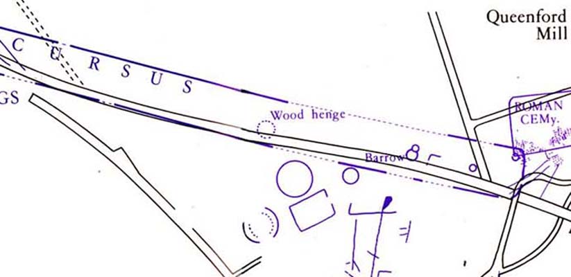
Dorchester's Woodhenge in the cursus
Dorchester’s Woodhenge in the cursus

Although ascribed as a wooden ‘henge’ by archaeologist Jean Cook, the site is more accurately a simple timber circle.  Cook (1985) described this little-known “Wood Henge” monument, as she called it, sat inside the lower southeastern end of the impressive Dorchester Cursus monument.  The site was obviously of some ritual importance, for a variety of reasons.  It was excavated in 1981 and,

“it consisted of a ring of large pits enclosing an area some 18m in diameter.  The site was situated along the central axis of the (Dorchester) cursus, presumably influenced by the alignment.  The pits, which varied in size, had each contained a wooden post, in three instances consisting of an entire trunk of an oak tree.  All the posts were burnt in situ, presumably during some form of destruction ceremony.”
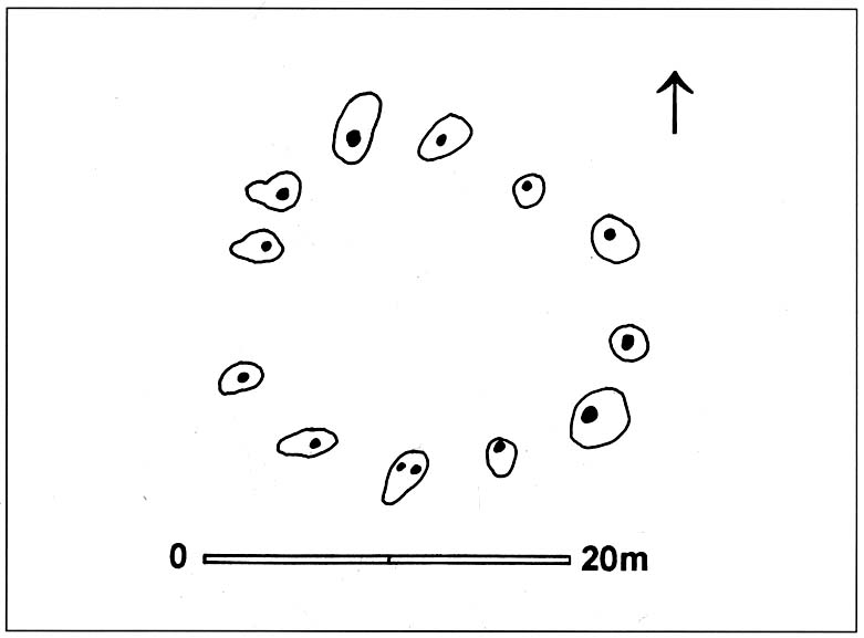
Groundplan of site

When Alex Gibson came here a few years afterwards to re-examine the site, his work and that of Richard Bradley (1988) also found the place to have been an elliptical ‘ring’ of once-upright timber posts.  Although Gibson (1998) later gave a confused version of where the site actually was (wrong grid-refs), his brief description gave us an outline of what was once here:

“An oval of 12 postholes containing the carbonized remains of 13 posts which had been burnt prior to the placing of cremations in the upper fills of the postholes.  The SW posthole contained the remains of two posts in the same socket.  There is a possible entranceway, marked by a wider gap between posts, in the NW.”

But this last line appears to be pure speculation. I’ve not read the longer archaeological accounts of this ‘wood henge’ and adjacent sites (Bradley & Chambers, 1988; Gibson 1992), which should give greater details about the site as a whole.  The Pastscape site gives the following information:

“A pit circle comprising a sub-circular arrangement of 12 pits was excavated in the early 1980s in advance of work on the Dorchester by-pass. The site lay within the Dorchester Cursus (SU 59 NE 5), circa 400 metres northwest of its southeastern terminal. The long axis of the pit circle was the same as that of the cursus. Each of the pits had held a timber upright, and some if not all had been burnt in situ. An air photograph of the site had suggested the presence of a central pit but this feature proved to be a natural pocket of sand. Six deposits of cremated bone came from various post pipes. Other finds included a handful of potsherds, one possibly of Early Bronze Age date, some animal bone fragments, and a few flints. Radiocarbon dates from cremated bone and charcoal centred on the mid 3rd millennium BC, with one slightly later.”

References:

  1. Bradley, R. & Chambers, R., “A New Study of the Cursus Complex at Dorchester-on-Thames, in Oxford Journal of Archaeology, volume 7, 1988.
  2. Cook, Jean, “The Earliest Evidence,” in Dorchester through the Ages, Oxford University 1985.
  3. Cook, Jean & Rowley, Trevor (eds.), Dorchester through the Ages, Oxford University 1985.
  4. Gibson, Alex, “Possible Timber Circles at Dorchester-on-Thames,” in Oxford Journal of Archaeology, volume 11, 1992.
  5. Gibson, Alex, Stonehenge and Timber Circles, Tempus: Stroud 1998.
  6. Pennick, Nigel & Devereux, Paul, Lines on the Landscape, Hale: London 1989.

© Paul Bennett, The Northern Antiquarian

Dyke Hills, Dorchester, Oxfordshire

Settlement:  OS Grid Reference – SU 5735 9364

Also Known as:

  1. Dorchester Dykes
  2. Dorchester Fort

Getting Here

Easy to find.  From Dorchester town centre, take the road at the bottom of town where the church is and walk along to the end where a footpath takes you into the field.  Once here you’ll note a rise in the land at the end, stretching away to the west and the River Thames.  That’s your Dyke Hills!

Archaeology & History

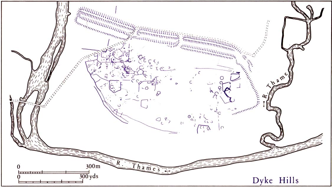
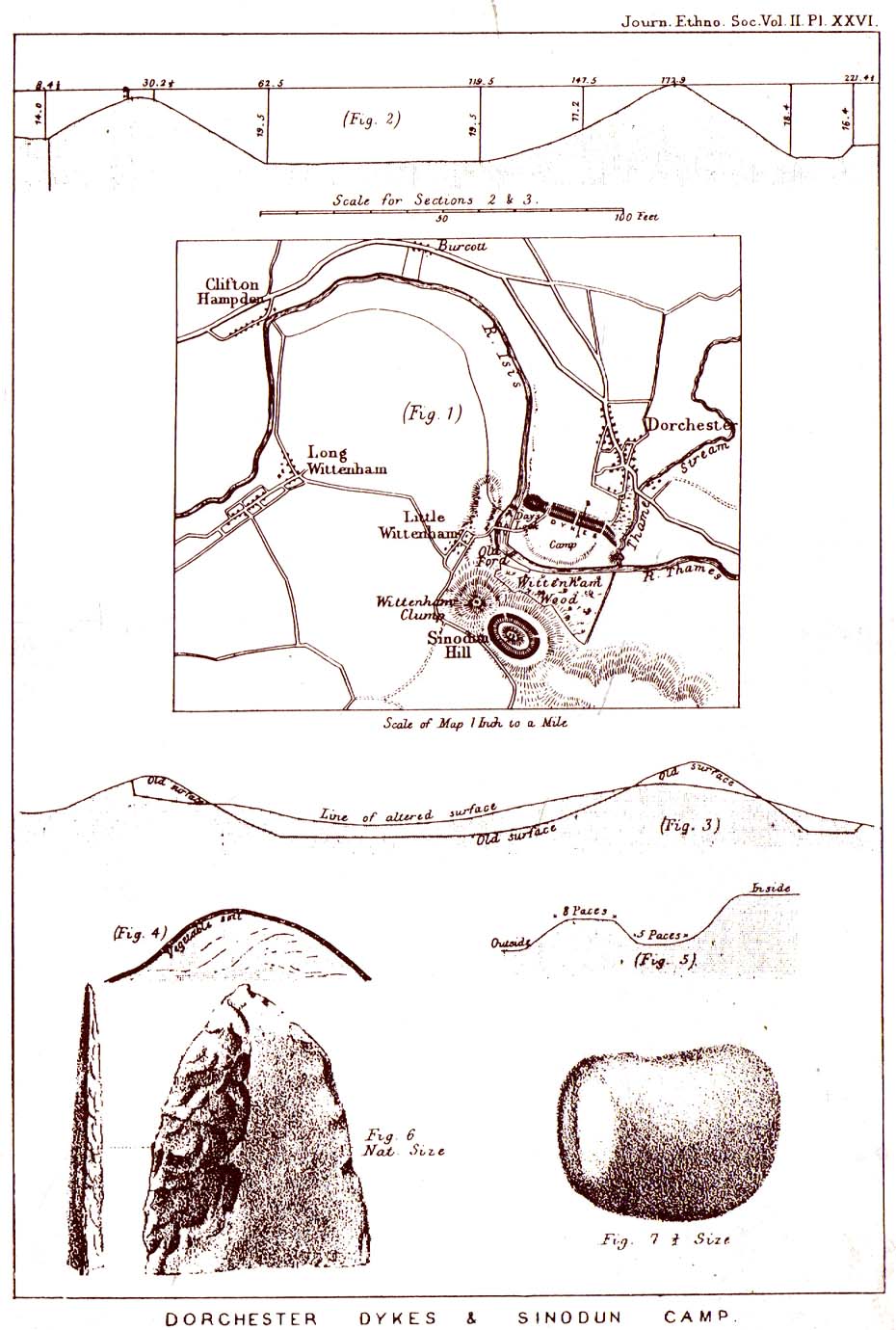
Plan of Dyke Hills (after Cook, 1985)

This site is another example of the considerable neglect shown to the prehistoric archaeological remains in and around the Dorchester region, despite Jean Cook (1985) describing the place as “a site of major local, regional and national importance.”  Which is a pity, as the site here was once huge and it seems that much could have been learned from here.  (you’ve gotta ask: do those doods who allegedly work for English Heritage care more for the ancient sites, or the money their organization gets?)

Lane-Fox’s 1870 survey

It would seem that the majority of the site was Iron Age in nature, with snifflings of Bronze Age remains scattered here and there. The primary position of the massive dykes and construction of internal domestic structures immediately below (south) of the dykes, was hemmed in on all sides by the surrounding River Thames and one of its tributaries, giving the place an excellent position in terms of food, plus shelter and protection from any intrusive tribes or hungry winter animals.

The first excavation at the huge dykes that define the northern edge of this ‘monument’ was done in 1870 by the renowned General Pitt-Rivers, then later Colonel Lane-Fox (at the time the Secretary of London’s Ethnological Society), as they were very concerned about the damage that was being inflicted upon the site, when the local landowner allowed sections of the banking to be “reduced for cultivation.”  An article in the Saturday Review magazine on July 2, 1870, told of these concerns and what was written — as Jean Cook so rightly tells — “has a depressingly modern ring to it”:

“…the fortress at Dorchester and the fortress on Sinodun (Castle Hill) are among the most speaking monuments of the earliest history of our island, and till lately they were among its most perfect monuments.  But it is a grievous truth that while we are writing, the dykes at Dorchester are being levelled.  Hitherto the neighbourhood ground has been grazed and the harmless sheep is no foe to history; but it has lately occurred to the owner of the ground hat a few shillings more of yearly profit might be gained by turning pasture land into arable; and to such a sordid motive as this these precious antiquities are at this very moment being sacrificed.  At least a third of the dyke has already been lowered, and will gradually be utterly destroyed beneath the yearly passage of ruin’s merciless plough share.  Such wanton destruction naturally aroused the indignation of men of taste and knowledge, especially in the neighbouring University.  A vigourous appeal to the owner to stay his hand was made by some of the most eminent Oxford residents, and an attempt was made to call public attention to the subject by describing the state of the case in various newspapers…”

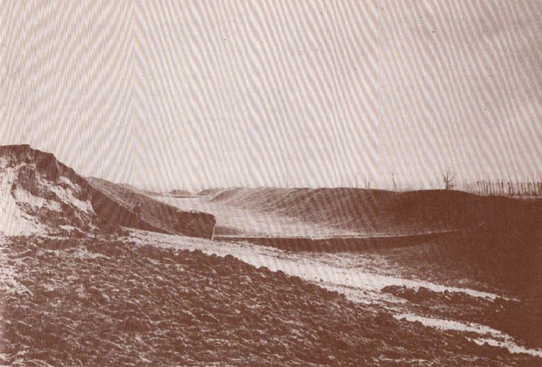
Lane-Fox’s 1872 photo

But the digging into the dykes continued.  For some time at least — until Colonel Lane-Fox himself went to the see the landowner and “persuaded” him to stop what he was doing.  A method we should always keep in mind ourselves…

The modern state of the Dyke Hills is summarised once again in Jean Cook’s (1985) fine survey of the region, where she wrote:

“This great enclosure, known to archaeologists as an oppidum, covered 46 hectares (c. 114 acres) and as defended by a massive double bank and ditch to the north and to the east.  The southern and western boundaries have all but disappeared, but can be traced in lines of modern field boundaries beyond which the Thames forms a natural boundary.  The interior is (now) empty, but cropmarks reveal that it is full of enclosures, pits and circular houses aligned along a regular pattern of internal roads.  Although there has been no scientific excavation within Dyke Hills, ploughing of the site has produced one of the densest concentrations of Iron Age coins in Britain.”

It would appear that this site was of considerable importance for local tribes and would have been home to powerful chiefs and impressive-looking shamans!  The large Castle Hill site immediately across the river would have had obvious links to this once-omportant prehistoric settlement.

References:

  1. Cook, Jean, “Before the Roman Conquest,” in Dorchester through the Ages, Oxford University 1985.
  2. Cook, Jean & Rowley, Trevor (eds.), Dorchester through the Ages, Oxford University 1985.
  3. Williams, Geoffrey, The Iron Age Hillforts of England, Horace Books 1993.

 © Paul Bennett, The Northern Antiquarian

Sonning Cursus, Reading, Berkshire

Cursus Monument:  OS Grid Reference – SU 7669 7599

Archaeology & History

Sonning Cursus & other ancient remains (after Ford 1987)

Barely visible nowadays, the site was described by archaeologist Steve Ford (1987) as, “a very convincing cropmark with markedly rectangular end with entrance gap” at its far eastern end.  This once impressive looking cursus aligns east-west and is found amidst a cluster of other neolithic and Bronze Age monuments.

It was first discovered by aerial surveying in 1959, but still remains unexcavated (I think!).  The dead straight neolithic monument,

“consists of parallel ditches 45 metres apart extending for at least 200m west towards lower ground.  The eastern end has a (flattened) terminal with a single entrance, whereas the western end is untraceable beyond a modern field boundary.”

In Roy Loveday’s (2006) survey, this cursus was stated as measuring 250m in length and 35m across.  Although the western end hasn’t been located, it’s highly probable that it reached to the River Thames a short distance away.  An excavation at one of the three ‘enclosures’ beyond the eastern end of this monument, revealed it have been built in the late neolithic period.

References:

  1. Ford, Steve, East Berkshire Archaeological Survey, Berkshire County Council 1987.
  2. Loveday, Roy, Inscribed across the Landscape, Tempus: Stroud 2006.

© Paul Bennett, The Northern Antiquarian

Drayton Cursus (north), Abingdon, Oxfordshire

Cursus Monument:  OS Grid Reference – SU 490 941SU 492 950

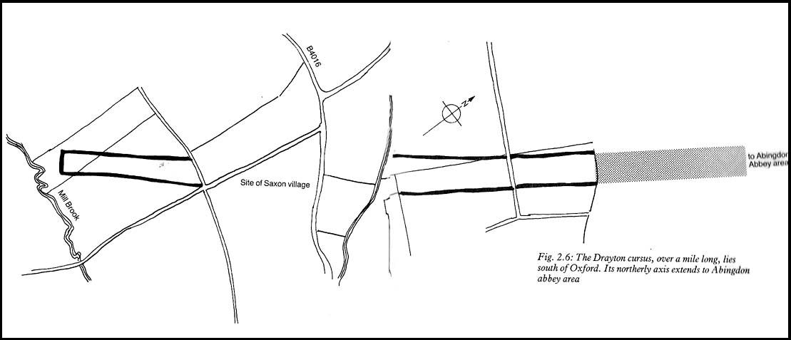
Drayton Cursus alignment (courtesy Paul Devereux)

Archaeology & History

This minor cursus monument was etched into the landscape in neolithic times.  Found to the south of Abingdon and close to the River Thames, one report showed finds from the site dating from 2900 BC.  There is also a neolithic henge monument very close to its northern terminus and a plethora of other Bronze Age remains all round.  Paul Devereux (1989) described how crop marks revealed,

“a substantial former cursus immediately to the east of Drayton: its crop marks extend southwest to northeast for a little over a mile, and are 225 feet (68 metres) wide. The cursus has a squared south end, but the northern terminus has not been found. The crop marks are not evident in the middle portion of the cursus, as it was formerly overlaid by a Saxon village. There is a plethora of other crop marks within and around the cursus… The northern section…which has a slightly different orientation to the southern segment, points squarely to the ancient heart of Abingdon.”

References:

  1. Ainslie, R. & Wallis, J., ‘Excavations on the Cursus at Drayton, Oxon’, in Oxoniensis 52, 1987.
  2. Barclay, A., Lambrick, G., Moore, J. & Robinson, M., Lines in the Landscape, OAU: Oxford 2003.
  3. Loveday, Roy, Inscribed Across the Landscape, Tempus: Stroud 2006.
  4. Pennick, Nigel & Devereux, Paul, Lines on the Landscape, Hale: London 1989.

© Paul Bennett, The Northern Antiquarian