Caravan Park, Blair Drummond, Stirlingshire

Tumulus:  OS Grid Reference – NS 7253 9906

Also Known as:

  1. Canmore ID 46065
  2. Old Farm

Getting Here

Caravan Park burial mound

Caravan Park burial mound

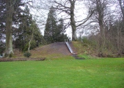
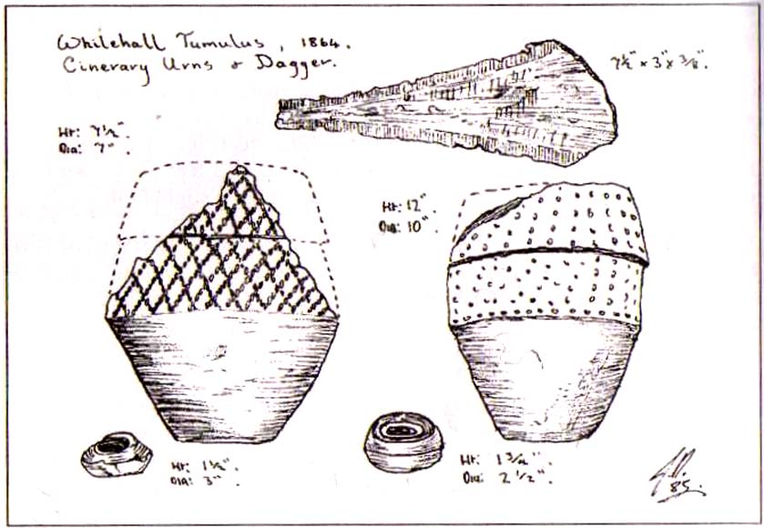
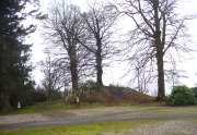
Along the A84 Stirling-Doune road, watch out for the minor Cuthill Brae road to the caravan park. Go up and into Blair Drummond caravan park (ignore the old grumpy southern-type fella who tells you “this is private”), right into and through the walled area where the caravans are situated.  Out the other side is a children’s playground— and the very large mound to your left with a tree on top (and a children’s slide built on it) is the burial mound in question.

Archaeology & History

Tumulus from the southeast

Tumulus from the southeast

This comes as something of a surprise when you first set eyes on it.  It’s big! (bigger than I expected anyway!)  Seemingly on its own, rising from the level ground and surrounded by cultivated land, there were probably others of its kin close by, but the closest that we know about is 1.5km to the east; although the standing stone of Boreland Hill a few hundred yards west might have had some relevance….

This tumulus may be the one noted by Charles Roger (1853) in his visit to the area.  He spoke of the now denuded burial mound to the east (in the Safari Park), but also told that,

“Within the park are two other tumuli, one situated in the garden, of a conical form and measuring 92 yards in circumference and about 15 yards in height…”

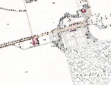
Blair Drummund tumulus on 1866 OS-map

Blair Drummund tumulus on 1866 OS-map

This mound is more 15 feet in height than yards, but the other measurement is close—and it does seem to be in the right area.

There is much greater certainty in J.G. Callander’s (1929) account.  He was fortunate in being part of the excavations undertaken here by Sir Kay and Lady Muir in 1927-28 and gave a damn good account of what went on:

“The mound is not quite circular, as it measures about 75 feet in diameter from north to south and about 65 feet from east to west, its height being about 15 feet.  Before the excavations were started it seemed as if the monument consisted entirely of earth, but before the examination was completed it was found that it contained a small cairn of stones, heaped over a grave formed of large slabs arid boulders which undoubtedly was the primary interment.

“Commencing at the south-south-eastern edge of the mound, a trench driven in towards the centre, revealed the presence of a short cist which had apparently been disturbed at some previous time.  A large block of stone formed the northern end and a large slab the east side.  A smaller slab lay at the south end and another on the west side, but as the latter was too short to fill the space, a larger slab lay obliquely between it and the large stone at the north end.  There was no appearance of a cover stone.  The length of this grave was 3 feet 3inches, its breadth 3 feet, and its depth 2 feet 3 inches.  The longer axis lay practically north and south.  No traces of human remains or relics of any sort were found here.  This was evidently a secondary burial sunk into the mound as far as the original surface of the ground, and covered with about 4 feet of soil at the centre.

“As the trees interfered with further excavations at this part, another trench was cut in from the northern arc as far as the centre of the mound, where an undisturbed cist, formed of large rough slabs and a cover stone, was encountered.  Although this grave was considerably larger in length, breadth and depth than any of the numerous short cists that I have examined, I think it should be classed with them rather than with the large cist-like chambers sometimes found in long cairns.  It was formed of two side and two end slabs.  The sides were roughly parallel, but the slab at the southern end was placed obliquely so that the length of the grave was 4 feet 6 inches on the east side and 4 feet on the west side. The general breadth was 3 feet at the floor, and the depth 4 feet.  Both side slabs converged towards the top.  As the slabs on the east side and at the ends were not so high as that on the west, the spaces between them and the cover stone were carefully built up with smaller stones.  A slight vacancy between the slabs at the south-east corner was filled in a similar fashion.  A small cairn of clean stones without a mixture of soil had been heaped up over the cist, covering the lid to a depth of about 9 inches: the diameter of the cairn at the base was  not ascertained.  The depth of earth above the summit of the cairn was about 8 feet.  But for a layer of a few inches of earth on the floor the cist was empty.  Nothing was found except some small unburnt fragments of human bone, very much decayed, and a few teeth.  Some small fragments of charred wood were found in making the trench and in the grave, but whether it was charred by natural carbonisation or by burning was not determined.

“In making the trench just before the grave was reached, but at a higher level, a small portion of the cutting edge of a stone axe was found.  It had no evident connection with the cist, and may have happened to be lying about amongst the soil that was piled up over the grave.

“As there remained a space on the top of the mound which could be excavated without destroying any of the trees, it was examined.  About 1 foot under the surface a cinerary urn was found in an inverted position.  The base had been crushed in, and the wall was full of cracks into which tree roots had penetrated.  On taking it out the vessel was found to have originally been about half-filled with cremated human bones.  These after examination were reinterred in the mound.  No other relics were found in the urn.

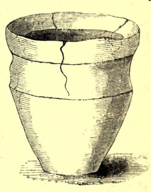
“The vessel, which is formed of buff-coloured clay with a tinge of red in places, is a cinerary urn of the cordoned variety belonging to the Bronze Age.  It is encircled at the widest part, about 3½ inches below the lip, by a raised moulding or cordon, and about 3 inches lower down by another.  The greater part of the vessel was recovered, but as the basal portion was completely crushed, it is impossible to ascertain the height of the vessel or the width of the base when complete.  It measures 10¾ inches in external diameter at the mouth and 11 inches at the widest part: what remains of the wall is 13 inches in height.  The rim, which is unusually thin for a vessel of this class, is only ⅜-inch in thickness, and it is bevelled downwards towards the interior.  The space between the upper cordon and the rim is the only part which is decorated, and here there is a row of large triangles, alternately plain and filled, with a reticulated design, bordered above and below with a single marginal line, all formed by pressing a twisted cord on the clay before it was fired.”

Protected tumulus, damaged by slide

Protected tumulus, damaged by slide

The burial mound is still in a reasonably good state of preservation… on the whole…  There is however, a slightly worrying note: this tumulus is a protected scheduled monument but despite this it has, as of late, been quite deliberately built upon.  When Penny Sinclair and I visited the nearby Christ’s Well recently (out of season), an unhelpful grumpy man working or living there told us we were “not allowed on the site – it’s private.”  We thought he was joking and I laughed that, “This is Scotland!”  He repeated his words.  A week later, Paul Hornby and I revisited the Christ’s Well and then took to see this large burial mound – only to find that a children’s play area had been built right up to, and upon, the northwestern part of the monument. This is in contravention of legal regulations to build upon Scheduled Monuments, as:

“The area to be scheduled encompasses the mound and an area around it in which traces of associated activity may be expected to survive.”

This has been violated.

If you like your prehistoric burial mounds, this is well worth having a look at.

References:

  1. Callander, J. Graham, “A Bronze Age Burial Mound at Blair Drummond, Perthshire,” in Proceedings Society of Antiquaries Scotland, volume 63, 1929.
  2. Roger, Charles, A Week at Bridge of Allan, Adam & Charles: Edinburgh 1853.
  3. Royal Commission on the Ancient & Historical Monuments of Scotland, Archaeological Sites and Monuments of Stirling District, Central Region, Society of Antiquaries of Scotland 1979.

© Paul BennettThe Northern Antiquarian


Hickford Hill, Belchamp St Paul, Essex

Enclosure:  OS Grid Reference – TL 7872 4537

Archaeology & History

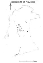
Ground-plan of enclosure & surrounding barrows

Plan of enclosure & surrounding barrows

Several hundred yards northeast from Hickford Hill, a cluster of prehistoric sites could once be seen close to each other just south of the River Stour below line of the Essex-Suffolk county boundary.  Several of these were tombs and are accounted for in Priddy’s (1981) essay on the prehistoric Barrows of Essex; but adjacent to them were also found faint traces of a large circular enclosure of some sort, which Harding & Lee (1987) included in their definitive survey of British henge monuments. Their account of it was brief and simple, saying:

“Enclosure defined by the cropmark of a sub-circular rather narrow ditch broken by two entrances.  No trace of a bank.  Internal traces of a concentric innner ditch in part of the circuit… Internal diameter range 56-57m…; width of outer ditch c.1.5-2.5m; width of entrances, c.7m (E) and 16m (NW); width of inner ditch c.2.5-5m.”

Although this large ringed enclosure was thought by the Haverhill & District Archaeology Group to “be a henge-type monument,” Harding & Lee (1987) thought it unlikely that these remains “belong to the henge class” of monuments.  A brief archaeological dig into one of the trenches here in 1997 showed the site to be Bronze Age; but finds by the local archaeology team have also come across finds in the fields hereby dating from the Mesolithic and Neolithic periods.

References:

  1. Harding, A.F. & Lee, G.E., Henge Monuments and Related Sites of Great Britain, BAR 175: Oxford 1987.
  2. Priddy, D., “The Barrows of Essex,” in A.J. Lawson’s The Barrows of East Anglia, Norfolk Museums Service 1981.

© Paul Bennett, The Northern Antiquarian

Badbury Barrow, Shapwick, Dorest

Tumulus:  OS Grid References – ST 9584 0294

Also Known as:

  1. Shapwick 6a (Grinsell)

Archaeology & History

One of the broken urns

Of at least 26 prehistoric barrows or tumuli in close proximity on the grasslands immediately west of the Badbury hillfort, this particular ‘Badbury Barrow’ as it’s generally called, was the most intriguing of the bunch.  Intriguing as it was found to possess a very rare carved stone near its centre, and had the elements of the dead laid out in a quite fascinating manner, with a large inner wall that surrounded the dead.  Grinsell (1959) posited that this site may be the same one described on the 1826 Greenwood Map of the region as the ‘Straw Barrow’ – in which case I’d love to know if there are earlier place-name references to the site and see what its name is thought to mean. (Mills’ PNs Dorset, 2, could be helpful – though it could be just ‘straw’!)  However, the Straw Barrow is some distance to the west of here.

The first lengthy description of the site was done very soon after the near destruction of the place in 1845.  A local man called John Austen visited and described the old tumulus in some considerable detail, and I make no apologies for adding his complete description of the barrow, as he found it, just before the land-owner levelled the place.  He wrote:

“On Nov. 1, 1845, I accidentally ascertained that a barrow situated about five miles from Wimborne, Dorset, upon the road leading to Blandford, and in the immediate neighbourhood of Badbury camp, was in progress of being levelled. The circumstance which chiefly attracted my notice was the vast quantities of large sandstones and flints which had been taken from it. Unfortunately nearly two-thirds of the tumulus were already removed. From the remainder, however, I have obtained a tolerably accurate idea of its interior arrangement, which, with perhaps the exception of the ‘Deverill barrow’, opened by W. Miles, Esq., in 1825, is more highly interesting than any yet examined. The labourer employed could give me but little information respecting the part already destroyed, further than that he had thrown up many pieces of pottery, and found one urn in a perfect state, but in removal he had broken it; sufficient however remained to enable me to ascertain its form and dimensions.  It measured 8 inches in height, 6¾ inches at the mouth, and at the bottom 3½ inches. The colour of the outer side was more red than is usual, and within it had a black hard ash adhering to the side, It was inverted, and contained only a few white ashes. It was ornamented with lines of from nine to fourteen fine pricked dots, as if made with a portion of a small tooth comb. Such an instrument was discovered a few years since by some workmen, whilst lowering a hill midway betwixt Badbury camp and the village of Shapwicke, having at one end a small circular hole, and at the other eight short teeth like those of a comb. It was four inches long and one inch wide, and was part of the rib of a deer…

“The barrow was circular, measuring about eighty yards in circumference, the diameter sixty-two feet, and the height nine feet; it had however been considerably reduced by the plough. Upon clearing a section across the centre, the following formation presented itself. The outside circle or foot of the barrow was of chalk, occupying a space of fifteen feet towards the centre. There was then a wall extending completely round, and enclosing an area of about thirty feet in diameter, composed of large masses of sandstone brought from some part of the heath, probably from Lytchett, a distance of not less than five miles, and across the river Stour. These stones were well packed together as in the foundations of a building, and the interstices tightly filled with flints. Within this wall, for the space of three or four feet, was a bed of flints, without any mixture of earth or chalk, packed together from the floor to the surface of the barrow, having only a few inches of earth above. The remainder of the interior was occupied by large sandstones, serving to protect the various interments.

Urn found in one cist

“About the centre I found six deposits. The most northern of these was the skeleton of a young child, by the side of which, proceeding west, there was a cist containing a deposit of ashes and burnt bones; and near it another, rather above the floor, containing burnt wood. Immediately beneath this was a cist containing an urn, placed with its mouth downwards, and filled with burnt bones, which were perfectly dry and white. It was without any ornament, and measured in height ten and a quarter inches; the diameter at the mouth, which turned outwards, was eight and three-quarter inches, and at the bottom four inches. The other cists contained burnt bones and ashes. Sandstones had been placed over them, but were removed without my having an opportunity of ascertaining their position. A short distance south of these deposits there was a cist containing the bones and skull of a young child, over which had been placed a flat sandstone, and about a foot from it appeared a deposit of small bones, occupying a space of only two feet ; these were apparently the remains of a woman. Immediately above was a row of sandstones, resting, as was usual throughout the barrow, upon a thin layer of burnt wood. At this spot the barrow appeared to have been opened after its final formation, as if for the purpose of a subsequent interment, and filled up, not with the earth of which the remainder was formed, but with loose chalk, there being no stones or flints above those which lay immediately upon the deposit. At the extreme south of these cists was a large sandstone, three feet in diameter by sixteen inches in thickness, placed edgeways. The above-mentioned cists were circular.

Upright urn outside of cists

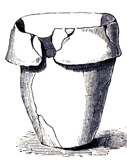
“A few inches west of the cist described as containing an urn, was the lower half of another, measuring in diameter five and a half inches, inverted, and placed upon the floor of the barrow, without any protection, merely surrounded by a thin layer of ashes and then the solid earth. It was filled with ashes and burnt bones, and rested upon the parts of a broken skull. Near this was an urn, also unprotected, and consequently much injured by the spade. It was placed upright, and measured in diameter nine and a half inches, by about ten inches in height. In form it resembled the urn first described, marked with impressed dots, but it was without any ornament. A short distance from these was a deposit of burnt wood at the west side of a large flat stone, placed edgeways, which measured three feet four inches by two feet ten inches, and thirteen inches in thickness. From its appearance it would seem that the fire had been lighted by its side. Immediately beneath the edge of this cist, and resting upon the chalk, was a small urn inverted, and by its side some small human bones. It was wholly unprotected, and unfortunately destroyed. South-east of this was a cist sixteen by twelve inches in diameter, and eighteen inches in depth, containing ashes and a few burnt bones, with a large-sized human tooth. Close to the edge of this cist, upon its western side, was placed in an upright position, a large stone measuring in diameter three by two and a half feet; and leaning against it another of still larger dimensions, inclining towards the north. This measured six and a half by four feet, and fifteen inches in thickness. About three feet further east were two large stones set edgeways, and meeting at their tops. Beneath them was the skeleton of a small child with the legs drawn up, lying from west to east. At the north-west side of the barrow, about five feet within the wall, was a cist cut in the solid chalk, measuring sixteen inches in diameter by sixteen in depth; it contained an urn inverted, and filled with burnt bones. Though carefully bandaged, it fell to pieces upon removal, being of more brittle material than any previously discovered. The clay of which it is formed is mixed with a quantity of very small white particles, having the appearance of pounded quartz.  It measured in height nine inches by nine and a half in diameter, and is ornamented by six rows of circular impressions made with the end of a round stick or bone of a quarter of an inch in diameter. The cist was filled up with ashes.

Small cup-like urn

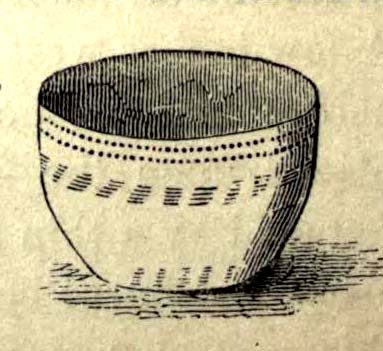
“A few inches from this was a cist differing in form, being wider at the top than beneath, in diameter eighteen inches by eighteen in depth; a flat stone was placed over it. It contained the skeleton of a young child, laid across, with the legs bent downwards. Lying close to the ribs was a small elegantly-shaped urn, measuring four inches in height by four in diameter, and made of rather a dark clay. It is ornamented with a row of small circular impressions, similar to those mentioned in the last instance, close to the lip, which turns rather out: beneath is a row of perpendicular scratches, and then two rows of chevrons, also perpendicular. At the feet of the skeleton was a peculiarly small cup, measuring in height one and a half inches by two and a quarter in diameter. It is ornamented with two rows of pricked holes near the top, beneath which is a row of impressions, made probably with an instrument of flat bone, three-eighths of an inch in width, slightly grooved across the end. The same pattern is at the bottom and upon the rim.

Another cup-like vessel

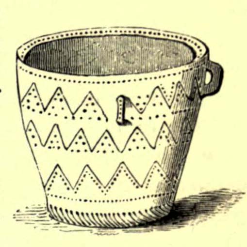
“Near this, towards the south-west, was a deposit of burnt wood, situated above the floor of the barrow, and immediately beneath it were two cists. In one of these, which measured two feet in diameter by one and a half in depth, were a few unburnt bones and several pieces of broken pottery, with a small cup, ornamented with three rows of the zigzag pattern, betwixt each of which, as well as upon the edge, is a row of pricked holes, and at the bottom a row of scratches. It measured in height two and a half inches by three in diameter, and had two small handles pierced horizontally: there appeared to have been originally four. In the other, which measured two feet in diameter by one in depth, were a few unburnt bones and a small urn placed with the mouth upwards, measuring four and three-quarter inches in height by the same in diameter. The lip, which turned very much out, is ornamented with a row of scratches, both within and upon its edge, a similar row also passes round near its centre. Close upon the edge of this cist was another urn of similar dimensions, inverted, and embedded in the solid earth without any protection. It is of much ruder workmanship than any of the others, and wholly unornamented, measuring five inches in height by five in diameter. Both these urns inclined equally towards the south-east. These last cists were partly, if not quite, surrounded by large sandstones set edgeways, and smaller ones built upon them, forming as it would seem a dome over the interments, filled with earth, and reaching to the surface of the barrow, where these stones have been occasionally ploughed out. From this circumstance, as well as the general appearance of the excavation, added to the description given by the labourer of the other part of the barrow, I am induced to suspect such to have been the case throughout… I found many pieces of broken pottery, and a part of a highly-ornamented urn. There was a total absence of any kind of arms or ornaments. The labourer however shewed me a round piece of thin brass, which he had found amongst the flints within the wall, measuring an inch and five-eighths in diameter. It had two minute holes near the circumference. It was probably attached to some part of the dress as an ornament. Teeth of horses and sheep were of frequent occurrence; I also found some large vertebrae and the tusk of a boar. Upon one of the large stones was a quantity of a white substance like cement, of so hard a nature that it was with difficulty I could break off a portion with an iron bar.

“If I offered a conjecture upon its formation, I should say that the wall, and foot of the barrow, which is of chalk, were first made, and the area kept as a family burying-place. The interments, as above described, were placed at different intervals of time, covered with earth (not chalk) or flints, and protected by stones. And over the whole, at a later period, the barrow itself was probably formed. My reason for this opinion is, first, that all these deposits, including, as they do, the skeletons of three or four infants, could scarcely have been made at the same time. And in the second place there was not the slightest appearance (with one exception) of displacement of the stones or flints in any way. As these circumstances then would suggest that the interments were formed at various periods, so the general appearance leaves no doubt as to the superstructure of flints, and surface or form of the barrow itself having been made at the same time and not piecemeal.

“I have met with no instance of a British barrow containing any appearance of a wall having surrounded the interments. Pausanias, in speaking of a monument of Auge, the daughter of Aleus king of Arcadia, in Pergamus, which is above the river Caicus, says, ‘ this tomb is a heap of earth surrounded with a wall of stone.’ And in the Saxon poem, ‘Beowulf,’ mention is made of a similar wall as surrounding the tomb of a warrior.”

One of the stones inside here was later found to possess “carvings of five cupmarks, two bronze daggers and two flat, triangular axes of early Breton type,” (Burl 1987) which Austen didn’t seem to notice at the time of his investigation.   A profile of the Badbury Barrow carving can be found here.

Folklore

In Peter Knight’s (1996) survey of megalithic sites around Dorset, he includes the Badbury Barrow along a ley line that begins at the tumulus just below (south) Buzbury Rings and then travels ESE for about 5 miles until ending at another tumulus at ST 006 996.

References:

  1. Austen, John H., “Archaeological Intelligence,” in Archaeological Journal, volume 3, 1846.
  2. Burl, Aubrey, The Stonehenge People, Guild: London 1987.
  3. Grinsell, Leslie V., Dorset Barrows, Dorset Natural History & Archaeological Society 1959.
  4. Knight, Peter, Ancient Stones of Dorset, Power: Ferndown 1996.
  5. Piggott, Stuart, “The Badbury Barrow, Dorset, and its Carved Stone,” in The Antiquaries, volume 19, 1939.
  6. Royal Commission on Historical Monuments, England, An Inventory of the Historical Monuments in the County of Dorset – Volume 5: East Dorset, HMSO: London 1975.
  7. Stone, J.F.S., Wessex Before the Celts, Thames & Hudson: London 1958.
  8. Warne, Charles, The Celtic Tumuli of Dorset, John Russell Smith: London 1866.

© Paul Bennett, The Northern Antiquarian

Ashleigh Barrow, Darwen, Lancashire

Tumulus (destroyed):  OS Grid Reference – SD 696 208

Also Known as:

  1. Whitehall Tumulus
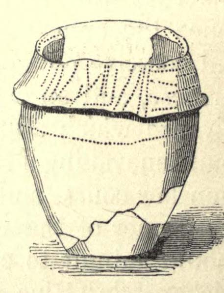
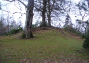
Ashleigh Barrow urns (after John Dixon)

Archaeology & History

Early accounts of this site tell of its destruction in the 19th century, but a modern reconstruction of the site has been made close to where it once stood.  And this tomb sounded quite impressive!  Within the ‘tomb’ were found a large number of urns, one of which was curiously empty.  In John Dixon’s excellent Journeys through Brigantia (2003) work he told that,

“Contemporary reports about its excavation state that it was of circular form about 30 yards in diameter, being formed on a naze or promontory of an undulating plateau overlooking the Darwen valley.  Its height was said to vary between 10 to 12 feet on the east side and between 2 or 3 feet on the west, the centre being about 6 feet in diameter and consisting of a slight hollow.

“Ten interments appear to have been made, one being just a heap of burnt bones, the others, having been enclosed in urns, the majority of which are badly broken, consisted of ashes and fragments of bone together with unrecognizable pieces of bronze.  Two urns also contained ‘incense cups’ and another a 7½-inch bronze knife or dagger.

“The design of the urns is similar to those from the Middle Bronze Age… All but two of the urns were found within an area 21 feet by 14 feet, whilst one was 40 feet away.  They were, with one exception, placed in the Earth with the orifice pointing upwards and were covered with slabs, the depth at which they were found varying from 1 to 2 feet.”

Remains of the urns can be seen on display in the Darwen Library.

Folklore

Once again in John Dixon’s (2003) fine Journey’s through Brigantia volume, we read of folklore relating to the respect of the dead which local people used to give this old tomb, telling:

“Many superstitions were attached to the barrow and its destruction in the 1860s, with the country people speaking of the place being haunted by ‘boggarts’ and children having been known to take off their clogs or shoes and walk past it barefoot in the night time.”

References:

  1. Dixon, John, Journeys through Brigantia – volume 11: East Lancashire Pennines, Aussteiger Publications: Barnoldswick 2003.

© John Dixon & Paul Bennett, The Northern Antiquarian