White Wells, Ilkley, West Yorkshire

Sacred Well:  OS Grid Reference – SE 1181 4677

Also Known as:

  1. Ilkley Spaw
  2. Mountain Spa
  3. Spa Well

Getting Here

White Wells (as Spa Well) on 1851 map

This place is one of the first things you see when roving the northern edge of Ilkley Moor.  Tis the small white house, perched on the hillside, which you can reach via the old track bending round to it on the west side, or the steep footpath which goes roughly straight uphill from the road, just above Ilkley Town centre, up (both) Wells Walk or Wells Road.  If you go just a few hundred yards up these roads, as the road bends and the moor opens up ahead, you’ll see the white building above you.  But if you’re truly useless at finding your way about, ask anyone of them there locals…

Archaeology & History

The White Wells, Ilkley Moor

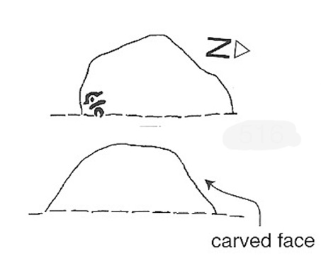
The White Wells have been described by countless writers over the centuries and attested as one of the great healing wells of the region. It was, without doubt, one of the most important water supplies to the indigenous Britons living on the moors here. One of their settlement sites is above the cliffs behind the modern position of the wells — though archaeological work has yet to be undertaken been.  Cup-and-ring marked stones scatter the edge of the ridge right above where the waters originally appeared (a few hundred yards further up the slope on the hillside, just below the trees); and the folk-memory of our ancestors living here is found in several adjacent sites known by ‘fairy’ place-names.

But today it looks nothing like it would have done when the ancient people of the moors drank these waters, nor even when the Romans came here.  For the white building which today houses the well was built around 1760 by the local Squire Middleton and originally contained three plunge baths in which folk would take the ‘cold water cure.’ (These were looked after by William Butler and his wife and were typically used by the gentry of the period, who it seems didn’t mind too much having to walk up the hillside to bathe in the “mellifluent, diaphanous, luminous waters.”)

Carved 'celtic' head, from which the water now emerges
Carved ‘celtic’ head, from which the water now emerges

The water in the house (you can go in and have a look), which now empties into a plunge pool, pours gently from the open mouth of a ‘celtic head’ – thought by some modern pagans to be ancient, but in fact is barely 200 years old.  The water at White Wells originally emerged from the Earth several hundred yards further up the slope, above the present position of the house, much closer to the moor edge near the bottom of the steep slope where the pine trees cling, amidst rocks, moss and lichen. Here is where the original waters were first borne.

Long held as being curative, the first detailed description of the place was in Thomas Short’s (1734) magnum opus, where he said:

“Ichley-spaw springs out of the middle of a mountain, a mile high, and consists chiefly of lime stone and freestone. The water is very clear, brisk and sparkling; has no taste, colour nor smell different from the common water, is of the same weight. Its bason and course are of no other dye than that of a common spring. About thirty-five years ago, there were a house and a bath built, about a furlong below the original spring, which spring was brought down in stone-pipes. The first spring, near the top of the hill was very weak and small; this, very large and strong; whereby there appears to be a large mixture of other springs with this; since which time, it has fallen much sort of its former great success. Twenty yard above the drinking well (over which is built a small house of a yard square on the inside) they have cut thro’ an original spring of common water. There are several old lime-kilns a little above this. The water is first whitish, then blackish purple with solution of silver; it’s very clear, and has a purplish pellicle, with solution of sublimate; it was first white, then clear in the middle, and a white mucus at the sides and bottom of the glass, with solution of Sugar of Lead; very clear, with Oil of Tartar; whitish, with Spirit of Hartshorn; and the same as common water, with all the other trials. Five pints of this liquor exhaled left seven grains of sediment, the salt whereof dissolved in distilled water, turned solution of silver purple; was white with Spirit of Hartshorn: therefore tho’ this water is of the greatest esteem and repute of any in the north of England, in the King’s Evil and other old ulcers; yet it derives these effects neither from its fixt nor volatile parts; but wholly from the coldness and purity of the element, its drying nature from the lime-stone it washes, tho’ a great part of it comes from blue clay.”

In 1830, one Thomas Shaw said of the place,

“The water is, perhaps, for its purity, tenuity and coldness, the best qualified to be of utility for relaxed and sedantry habits of any water in this part of the country. It has frequently been analysed, but the decomposition always proved that it contains no medicinal quality. In my opinion, it is its purity and softness only, which makes if more efficacious, by passing sooner and to the utmost and finest limits of the circulation than any water known.”

But although many cures were claimed of the waters here, as Kathleen Denbigh (1981) wrote:

“According to a 1977 analysis, it is simply a clear, colourless spring water of moderate hardness, organically pure and free from metallic contamination and coliform organisms.” — i.e., it’s good clean water!

When the place gained a reputation as a spa, it was frequented by such notaries as Charles Darwin, Frederick Delius and Prof. David Baldwin. But even before this, in 1709, Dr Richard Richardson of Bradford—a reputable naturalist but also with considerable interest in ancient and occult matters—wrote that the site “has done very remarkable cures in scrofulous cases by bathing and drinking of it.”

Folklore

Rare photo of William Butterfield (the old keeper of White Wells), who reported seeing 'little-people' here
Old photo of Mr Butterfield, who saw fairies here

Popularly believed in local lore to have been a place held as sacred to the Romans, I’m of the opinion that the local ‘goddess’ Verbeia was resident here. A thought also mentioned by G.T. Oakley (1999) in his book on the subject.

Legend tells that the medicinal properties of the waters were first discovered hundreds of years ago when an old shepherd, walking over the moors, damaged his leg. Upon bathing it in the waters here, it soon healed.

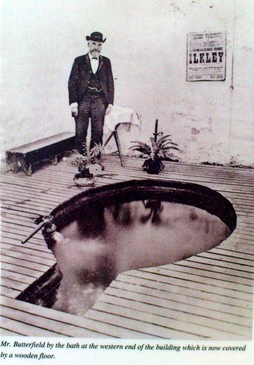
In the Folklore Record of 1878 we find a fascinating tale about these waters, alleged to have happened to the old keeper of the place, told by a local man John Dobson, and which cannot go untold:

“William Butterfield…always opened the door first thing in the morning, and he did this without ever noticing anything out of the common until one beautiful, quiet, midsummer morning. As he ascended the brow of the hill he noticed rather particularly how the birds sang so sweetly, and cheerily, and vociferously, making the valley echo with the music of their voices. And in thinking it over afterwards he remembered noticing them, and considered this sign attributable to the after incident. As he drew near the wells he took out of his pocket the massive iron key, and placed it in the lock; but there was something “canny’ about it, and instead of the key lifting the lever it only turned round and round in the lock. He drew the key back to see that it was alright.and declared, “It was the same that he had on the previous night hung up behind his own door down at home.” Then he endeavored to push the door open, and no sooner did he push it slightly ajar than it was as quickly pushed back again. At last, with one supreme effort, he forced it perfectly open, and back it flew with a great bang! Then ‘whirr, whirr, whirr’, such a noise and sight! All over the water and dipping into it was a lot of little creatures, all dressed in green from head to foot, none of them more than eighteen inches high, and making a chatter and jabber thoroughly unintelligible. They seemed to be taking a bath, only they bathed with all their clothes on. Soon, however, one or two of them began to make off, bounding over the walls like squirrels. Finding they were all making ready for decamping, and wanting to have a word with them, he shouted at the top of his voice—indeed, he declared afterwards, he couldn’t find anything else to say or do—”Hallo there!” Then away the whole tribe went, helter skelter, toppling and tumbling, heads over heels, heels over heads, and all the while making a noise not unlike a disturbed nest of young partridges. The sight was so unusual that he declared he either couldn’t or daren’t attempt to rush after them. He stood as still and confounded, he said, as old Jeremiah Lister down there at Wheatley did, half a century previous, when a witch from Ilkley put an ash riddle upon the side of the River Wharfe, and sailed across in it to where he was standing.1 When the well had got quite clear of these strange beings he ran to the door and looked to see where they had fled, but nothing was to be seen. He ran back into the bath to see if they had left anything behind; but there was nothing; the water lay still and clear as he had left it on the previous night. He thought they might perhaps have left some of their clothing behind in their haste, but he could find none, and so he gave up looking, and commenced his usual routine of preparing the baths; not, however, without trotting to the door once or twice to see if they might be coming back; but he saw them no more.”

Along with sightings of ‘little people’, ghosts have been seen at the White Wells.  It is thought that the strange apparition which presented itself to a householder here in 1982—the ghostly figure of a young girl, weeping at the water’s edge—was that of little Ann Harper who, in August 1793, at the age of nine, drowned in the well when bathing.

Earthlight (UFO) phenomena have also been reported here over the years—the most dramatic of which was alleged to have taken place at the top of the slope above the original source of the wells in 1989, when a police officer reported and photographed a “little green man” on the geological prominence just behind the wells. He went on to narrate a typical UFO ‘abduction’ event, but much of this was psychogenic and the mythic undertones echo precisely the medieval lore of abduction by faerie.

The Fortean researcher David Barclay found in his dowsing investigations here that there were spiral patterns all round the place. “At first these were in no order,” he wrote, “but through a period of over twenty visits to the place, I established markers which indicated the spiralling patterns of the energy” within the Earth immediately adjacent to the White Wells. These spirals were nearly always in a clockwise direction. In further studies here, he and I came to know a Mrs Elsie Hill, who had done some quite striking automatic drawings of the place. “In her pictures,” he wrote, “appear a prominence of spiral-forms and faerie creatures which, she believes, inhabit White Wells.”

Hmmmm…..

…to be continued…

References:

  1. Bennett, Paul, The White Wells, Ilkley Moor, Heathen Earth: Keighley 2009.
  2. Bogg, Edmund, Upper Wharfeland, James Miles: Leeds 1904.
  3. Collyer, Robert & Turner, J. Horsfall, Ilkley, Ancient and Modern, William Walker: Otley 1885.
  4. Denbigh, Kathleen, A Hundred British Spas, Spa Publications: London 1981.
  5. Granville, A.B., Spas of England, Henry Colburn: London 1841.
  6. Oakley, G.T., Verbeia: The Goddess ofWharfedale, Rooted Media: Leeds 1999.
  7. Shaw, Thomas, The History of Wharfedale, Otley 1830.
  8. Short, Thomas, The Natural, Experimental and Medicinal History of the Mineral Waters of Derbyshire, Lincolnshire and Yorkshire, privately printed: London 1724.
  9. Speight, Harry, Upper Wharfedale, Elliott Stock: London 1900.
  10. Whelan, Edna and Taylor, Ian, Yorkshire Holy Wells and Sacred Springs, Northern Lights: York 1989.

© Paul Bennett, The Northern Antiquarian 


Tobar nam Buadh, St. Kilda, Outer Hebrides

Holy Well: OS Grid Reference – NA 0863 0024

Tobar nam Buaidh on 1928 map

Also known as:

  1. Canmore ID 3962
  2. Tobar-ianadaiche-buadhan
  3. Well of Virtues

Archaeology & History

This legendary healing spring (the Well of Virtues) is on the north side of the island, a few hundred yards northwest of the legendary Amazon’s House. Martin Martin (1703) told that this well,

“near the female warrior’s house is reputed to be the best, the name Toubir-nim-buey, importing no less than the well of qualities or virtues; it runneth from east to west, being sixty paces ascent above sea; I drank of it twice, and English quart at each time; it is very clear, exceeding cold, light and diuretick; I was not able to hold my hands in it above a few minutes, in regard of its coldness; the inhabitants of Harries find it effectual against windy-chollicks, gravel, head-aches; this well hath a cover of stone.”

The reverend Kenneth Macaulay (1764) also wrote of this place, giving additional details:

“Near the fountain stood an altar on which the distressed votaries laid down their oblations. Before they could touch the sacred water with any prospect of success, it was their constant practice to address the genius of the place with supplication and prayer. No one approached him with empty hands. But the devotees were abundantly frugal. The offerings presented by them were the poorest acknowledgements that could be made to a superior being, from whom they had either hopes or fears. Shells and pebbles, rags of linen, or stuffs worn out, pins, needles or rusty nails, were generally all the tribute that was paid; and sometimes, though rarely enough, copper coins of the smallest value.”

T.S. Muir’s sketch

There was a very small stone-built well-house with a low roof covering the top of the spring, inside which a small pool formed.  The small well-house was described by Thomas Muir (1883) and ruins of it are reported to still cover the sacred waters, which run into an old stone trough.  Muir called it the ‘spring of many virtues’, describing it as one of five holy wells on this small isle.

In James MacKinlay’s (1893) magnum opus he reported that its waters could cure deafness.

References:

  1. Macaulay, Kenneth, The History of St. Kilda, James Thin: Edinburgh 1974 (original edition 1764).
  2. MacKinlay, James, Folklore of Scottish Lochs and Springs, William Hodge: Glasgow 1893.
  3. Martin, M., Description of the Western Isles of Scotland, Andrew Bell: London 1703.
  4. Mathieson, J., “The Antiquities of the St. Kilda Group of Islands,” in Proceedings Society of the Antiquaries Scotland, volume 62, 1928.
  5. Muir, Thomas S., Ecclesiological Notes on some of the Islands of Scotland, David Douglas: Edinburgh 1883.

© Paul Bennett, The Northern Antiquarian


Holy Well, Eccleshill, Bradford, West Yorkshire

Holy Well:  OS Grid Reference – SE 1878 3622

Getting Here

Take the A658 road north out of Bradford, past Undercliffe, and downhill towards Greengates.  When you meet with the large junction where Ravenscliffe Avenue turns to your right – stop!  Immediately on the left-hand side of the road is where the old well used to appear.

Archaeology & History

Old map showing Eccleshill's Holy Well
Old map showing Eccleshill’s Holy Well

In times past this was one of the most renowned holy wells in the region (we have at least 200 in West Yorkshire). First recorded as a holy well in 1585, specialist writer Edna Whelan remembers the waters here running into a stone trough at the side of Harrogate Road when she was young.

In 1932, local historian W.E. Preston described, “the remains of what was once a fine grove of trees leading up the hillside from the road to its source,” implying ritual commemoration and a procession to the site.  Today, this grove is still evidenced by the straight footpath across the main road, leading to the infamous Ravenscliffe estate.

In 1704 a court case was brought against some locals – Mr & Mrs Richard and Sarah White (and their daughter, Mary) – “for diverting the water from its ancient channel.”

In 1867 it was described in the Object Name Book:

“A considerable and well-known spring, it has the appearance of having been a bathing place. A bank has been thrown up on the east side, and a broken wall remains on the other sides. There is no tradition about it. It is likely to have been of some note…in the days of Romanism. Large trees are ranged on either side of the approach to it, forming a grove.”

Up till 1978, Andrea Smith (n.d.) reported the well to still be “protected by local tradition,” but this is no longer possible. Yorkshire Water don’t particularly give a damn about its preservation (water is money folks!) and today it’s covered by a man-hole in the garden.

References:

  1. Preston, William E., ‘Notes on the Early History of the Manor of Eccleshill,’ in Bradford Antiquary, 5, 1912.
  2. Preston, William E., ‘Some Local Holy Wells,’ in Bradford Antiquary, June 1932.
  3. Smith, Andrea, ‘Holy Wells Around Leeds, Bradford & Pontefract,’ in Wakefield Historical Journal 9, 1982.
  4. Whelan, Edna & Taylor, Ian, Yorkshire Holy Wells and Sacred Springs, Northern Lights: Pocklington 1989.

© Paul Bennett, The Northern Antiquarian


Askwith Moor (515), North Yorkshire

Cup-Marked Stone:  OS Grid Reference – SE 1668 5056

Also Known as:

  1. Shooting House West carving 

Getting Here

From Askwith village, at the T-junction, go up Moor Lane, taking the left turn up Moorside Lane about half-a-mile up and on the track to Moorside Farm and then onto Top Moorside Farm.  Take the path past the farm up onto the moor, then bear right up the small track that heads up onto the small Hollin Tree Hill.  As you go up the track, watch out for the small grassy depression to the right; and hereby head into the grasses on your right.  You’re close!

Archaeology & History

Image © Graeme Chappell
Image © Richard Stroud

Graeme Chappell was the first to rediscover this carving in the early 1990s when we were up pottering about on these and the adjacent moors, looking for any previously undiscovered prehistoric relics.   We found quite a lot!  The carving here is nowt special to look at really, but the cups can be seen quite clearly.  It’s a rather large stone on the western edge of the hill with at least seven or eight cup-marks carved across its upper surface.  Boughey & Vickerman (2003) later described it as “large, fine quartz sandstone rock with surface sloping slightly down into (the) hillside.  Seven or eight cups, two particularly sharp.”  There’s a possible line running between two of the cups, visible when lighting conditions are right — though we aint sure whether it’s artificial or not.

References:

  1. Boughey, Keith & Vickerman, E.A., Prehistoric Rock Art of the West Riding, WYAS 2003.

© Paul Bennett, The Northern Antiquarian


Apronful of Stones, Giggleswick, North Yorkshire

Cairn:  OS Grid Reference – SD 80652 66193

Also Known as:

  1. Scar Pasture

Getting Here

The scattered heap, looking south

Paul, Danny and I came here via the Feizor village route, zigzagging about, to and fro, seeing the other old sites in the region; but the easier direct way to get here would be from Settle.  Walking through Settle, going out of the top end of town, cross the old bridge and take the country-lane on the right, up northwards towards Stackhouse.  A mile along the road (shortly before Stackhouse), a footpath on your left veers up diagonally through a small copse of woods. Go up here and out the other side of the trees, the path turns left and up over the fields.  Go up here, and over the third wall along the footpath, you’ll see a large overgrown pile of rocks 30 yards in front of you with a large stone laid roughly in its middle.  You’re here!

Archaeology & History

This is an excellent though much neglected prehistoric cairn of some considerable proportions, its rocky mass laying half-covered in deep earth and grasses, yet with still a very large section of it open to the elements.  The creature is nearly 30 yards across and some 4 yards high — though it’s hard to say with any certainty, where exactly the natural Earth begins and the cairn starts.  But from whichever way you look at this large cairn, walking around the overgrown features, you know it’s a big thing — similar in size and nature to the Great Skirtful of Stones on Burley Moor, and the neolithic cairn on Bradley Moor, near Skipton.

Paul & Danny atop o’ t’ pile
Bear’s photo, looking SW

On the modern OS-map there are 2 ancient cairns marked close to each other — and our “Apronful of Stones” is the lower one of the two.

In recent years the site was described briefly in Dixon’s (1991) Journey through Brigantia, but there’s been very little written about the place in modern archaeological surveys.  The first account I’ve found of the site was written by an anonymous “W.F.” in The Gentleman’s Magazine of 1784.  In a detailed lengthy essay, the following words were penned:

“This barrow, or tumulus, stands in an elevated situation, upon a mountain, above the hamlet of Stackhouse, and may be discerned at a great distance…

“The form of this vast mass is circular, or rather orbicular ; the height, by computation on the spot, about 9 or 10 feet. It is composed of an incredible quantity of stones, piled in such a manner as to rest upon each other’s basis, and strengthened by its conic form, it rises upwards in this curious shape. Those stones that form the outside of the work are so small that a soldier could carry them; and since it has been argued that such a monstrous work as this would not be attempted by any nation, but was natural, the largeness of the tumulus may easily be accounted for, since they were annually increased out of reverence…

“This barrow had been opened many years ago, and it is represented in the plate in the state in which it has appeared till lately. Some old people in the neighbourhood remember its being entirely complete, and having a very flat top. It was usual, in finishing these works, to lay a flat stone at the top. The people that opened it left their intention unfinished, only throwing down the lid of the stone coffer, and one or two of the sides; and, meeting with nothing worth digging for, they left it. Upon examining it in this state, before its being entirely disfigured in the last attempt, I found several human bones scattered up and down therein, amongst which I selected the patelae of the knee, the vertebrae of the spine, part of the jaw, and several teeth.

“Round the area is a wall or rampart, of the same materials as the outside, its height from the interior part about 2 feet, irregularly ranged with fissured remnants. In the centre of the cavity or area is the above chest, consisting of several huge stones of vast magnitude and density, fixed firmly into the ground, which supported a lid of equal size, though it is now thrown off the top. In this chest are partitions, for what purpose is not known, unless each space was allotted to its particular relique or body. In the partitions and sides of the coffin is a kind of hole in the edge, with a rude mould. (my italics, PB) Not many weeks ago, the curiosity of some of the neighbourhood was excited to investigate this stupendous work of art, and accordingly labourers were hired, when, upon searching a day (yet not half the work done), a human skeleton was found, in due proportion, and in a fine state of preservation, excepting the skull and one of the limbs, which were moved out of their place by the workmen’s tools. A small circular piece of ivory, and the tusk of an unknown beast, supposed to be of the hog genus, was also found ; but no ashes, urns, coins, or instruments were discovered. ”

Many years later the giant cairn was described briefly in William Howson’s (1850) early survey of the district, when he told that,

“Near a gate on the path, where the descent is commenced to Stackhouse, there’s a cairn of eighty feet in diameter; it has not been completely examined, but human bones are commonly found in it.”

But it was more than a century after “W.F.’s” initial essay before another detailed appraisal of the place was given — and that was after a visit here by the legendary Harry Speight (1892) in the latter half of the 19th century.  Along with mentioning a number of other prehistoric tombs upon this ridge, Mr Speight told:

“From Settle Bridge you may take the field-path…or the rustic lane to Stackhouse, and where the road divides just beyond Mr Priestley’s pretty house you wind beneath the wood behind Scale House to a gate and stile on the left. Here ascend the field between two large trees, and at the top go over a stile, whence a path leads up the field a good half-mile to a gate which opens into what our remote Celtic ancestors would have reverentially called the ‘Field of the Dead,’ for within this enclosure are traces and remains of human graves which carry us back to the far dim ages of unwritten history. Following the grassy cart-road a short distance you will see on the left a large circular mound thrown up about 30 feet on the south side, and about 10 feet on the north or higher side. There are other mounds of similar and smaller dimensions within the same area, some of which have been examined, but others do not appear to have been disturbed. Many of the barrows or ‘raises’, have at some time or other been carelessly dug into in the hope of finding valuables, and as doubtless in most cases nothing was found but rude chests or coffins, containing bones, these were tossed aside and no record of them deemed worthy of preservation…

“The largest of these existing raises has happily been described by a writer who signs himself ‘W.F.’ in the ‘Gentleman’s Magazine’ for 1784 and 1785. Although his account fills several pages, it is obviously defective in many particulars. We are told that the circumference of the base of the mound is 210 feet, and that its height is 9 or 10 yards, and that the casing is composed of stones “so small that a soldier could carry them,” while the inside is made up of earth and stones, some of the latter being “much larger than the external coating.” In form it was circular…and the diameter of the summit was 45 feet. The barrow he tells us was opened many years ago, but some old people in the neighbourhood remember it being entirely complete, and having a very flat top.

“…Upon examining it in its former state the writer discovered several human bones scattered about the rock and soil, among them the palletae of the knee, the vertebrae of the spine, part of the jaw and several teeth. In the centre of the mound was a cavity containing a chest composed of four upright stones and a lid 6 feet 9 inches long and 3 feet broad. The chest was in partitions, in the edges of which were a kind of hole with a rude mould. The writer, under date, Settle, Nov 23rd 1784, next informs us that, “not many weeks ago the curiosity of some of the neighbourhood was excited to investigate this stupendous work of art, and accordingly labourers were hired, when upon searching a day (yet not half the work done) a human skeleton was found, in due proportion, and in a fine state of preservation, excepting the skull and one of the limbs, which were moved out of their place by the workmen’s tools. A small circular piece of ivory, and the tusk of an unknown beast, supposed to be of the hog genus, were also found; but no ashes, urns, coins, or instruments were discovered.”

Other important prehistoric monuments can be found on the grassy limestone plain beyond the Apronful: these include the fascinating Sheep Scar Enclosure just 180 yards (165m) to the north; an associated prehistoric cairn (one of several) 57 yards further northeast; and a delightful, though overgrown cairn circle 325 yards NNW.  Other Iron Age and Bronze Age remains can be found elsewhere within this arena.  Archaeologists could do themselves a big favour by exploring this landscape more efficiently than they’ve done so far as other unrecognized sites exist in this area.

Folklore

Big stone in t’ middle

Harry Speight (1892) told us how the place got its name “from a tradition…that his Satanic Majesty, in haste to complete the bridge bearing his evil name near Kirkby Lonsdale, tripped and his apron-string broke which let drop this immense heap.”

Another tradition narrated again by our anonymous ‘W.F.’ in the Gentleman’s Magazine(1785) said how this giant tomb, “was raised over the body of some of the Danes slain in the general massacre of that nation.” He also told, “Such a conspicuous work must certainly be erected to the manes of some chiefs, though there is no ground to support its tradition.”

References:

  1. Dixon, John & Phillip, Journeys through Brigantia – volume 4: Beyond the Hill of Winds – Walks in Upper Ribblesdale, the Three Peaks & Upper Wharfedale, Aussteiger: Barnoldswick 1991.
  2. Ferrand, William, “Stackhouse, Yorkshire,” in The Gentleman’s Magazine (London 1784).
  3. Howson, William, An Illustrated Guide to the Curiosities of Craven, Wildman: Settle 1850.
  4. Speight, Harry, The Craven and Northwest Yorkshire Highlands, Elliott Stock: London 1892.

Links:

  1. Images and walk to Apronful of Stones and nearby sites

© Paul Bennett, The Northern Antiquarian


Devil’s Apronful, Pendle Hill, Lancashire

Cairn:  OS Grid Reference – SD 77907 39357

Also known as:

  1. Apronful of Stones

Getting Here

The much-denuded Devil's Apronful giant cairn
The much-denuded Devil’s Apronful giant cairn

Many ways to get here, but the easiest for those with cars to is park up on the southeast edge of the hill, at the various scruffy parking bits beside the road at the Nick of Pendle. The view from here is enough to get you going! Walk onto the great hill up to the rounded pap of Apronfull Hill (rather gives it away really!). It’s only a few hundred yards up – about 10 mins up the slope from the road, with awesome views all round once you get there. Tis the small guidance cairn you’re looking at just on the level. You’re there!

Archaeology & History

This would once have been a rather huge cairn/tomb — though when I first found the remains of this place in August 2006, there were no archaeological records describing it that I could find.  But there’s very little left of it.  The lads who did the quarrying further downhill (where you’ve probably parked your car) are likely to have been the culprits who nicked most of the rocks that once made this huge forgotten tomb. But as you potter about here, it becomes obvious that you’re standing on the much-denuded remains of just such a monument (very similar in size and structure to the more famous Little Skirtful and Great Skirtful of Stones on Burley Moor, or Black Hill round cairn near Skipton).  But the remains you can see beneath your feet still give a good idea as to how large it was.

Remnants of the cairn-spoil cover the ground where the monument once stood proud!

You’ll see once you’re stood here that there are hundreds, maybe even several thousands of stones just on and below the ground, scattering a very well-defined roughly circular area measuring at least 21 yards (east-west) by 22 yards (north-south), right by the side of the path. The edges of this ransacked cairn are pretty well defined around the north and eastern sides. Near the centre of the old structure is a very notable ‘dip’ in the ground where it looks as if something has been dug away — though this could just as well be due to the presence of underground water, as indicated by the growth of Juncus grasses.  Without an excavation it’s obviously difficult to tell.

Folklore

Twas the following tale which first led my nose to explore this part of Pendle hill. It’s a tale we find at many of our upland tombs, though the record books said there was nowt here! (any myopic archaeologists out there who reckon that folklore has no relevance to their subject, educate one’s self!)

Looking from the Devil's Apronful towards Jeppe Knave's Grave
Looking from the Devil’s Apronful towards Jeppe Knave’s Grave

The Devil was having trouble with the folk at Clitheroe Castle (a few miles west) and wanted rid of it. So he picked up various large stones and put them in his apron then threw them towards the castle. Most of them missed, which made him angry and in a rage he accidentally dropped a great pile of rocks on the south side of Pendle Hill, creating the Devil’s Apronful on Apronfull Hill.

In another tale he was said to have stood at the Deer Stones a few hundred yards east of here and threw rocks from there. Perhaps a folk-remnant of where the Apronful stones once came from…? Perhaps not.

Jessica Lofthouse (1976) notes how this old spot was long known by local people as the Devil’s Apronful.

References:

  1. Lofthouse, Jessica, North-Country Folklore, Hale: London 1976.

© Paul Bennett, The Northern Antiquarian


Fornham All Saints, Bury St. Edmunds, Suffolk

Cursus:  OS Grid Reference – TL 8406 6732 to TL 8291 6876

Also known as:

  1. All Saints Cursus
The Forham All Saints Cursus (image courtesy, Paul Devereux)

Archaeology & History

The remains of this cursus can be found in the valley of the Lark.  In Paul Devereux’s (1989) survey of these gigantic neolithic features he described how today we can only see it as crop-markings, stretching in a

“roughly northwest to southeast direction for about a mile; its width approximately 140 feet (42.5 metres). It is comprised of three straight lengths, each at slightly different orientations – there is no way of telling at present (c.1988) whether or not these segments were built at different times, as is believed to be the case at certain other cursuses where changes of direction occur. The northmost terminus has not been located, but the southern one is visible from the air and is next to a circular crop-mark.”

Some 350 yards further on from the end of the cursus is the village church of All Saints, whose old festival date centred around Halloween, or the old pre-christian New Year.

Central section of cursus

Starting at the southern end of the cursus (A), it headed northwest for more than 650 yards (0.6km) before it took its first slight change of direction.  Almost all of this first section has been built over by the village; but we can see it in aerial views again on the north side of the village at the edge of the field, at TL 8365 6774 (B).  Changing direction slightly, it moves more NNW for another 590 yards (539m) and then kinks again slightly more NNW at TL 8325 6809 (C), before heading onto its final change in direction 464 yards (424m) away at TL 8299 6843 (D).  From this point, more recent surveys have shown it to continue further onwards, with another minor alteration in its direction to the north.  It goes in a dead straight line for another 336 yards (334.5m), seemingly terminating a short distance before the old Mill Farm at Hengrave, at TL 8291 6876.  Just as at the start of the cursus at point ‘A’, where the terminus is curved in a slight arc, so the northern terminus was also curved.  The total length of this monument is 1.2 miles (1.9km).

As can be seen in the aerial view (above), a faded double-line of earthworks exists immediately west (left) of the cursus, intersecting and going across the monument.  This is the Fornham All Saints causewayed enclosure: another early neolithic monument which may or may not be earlier than the cursus itself.

A curious architectural coincidence (?) can be seen roughly 500 yards west of the central section of the cursus. Running roughly parallel with the prehistoric earthwork is another dead straight avenue leading out, southeast, from Hengrave Hall and, near its terminus, kinks slightly left, just as the cursus monument does about 550 yards away. Fascinating…

References:

  1. Loveday, Roy, Inscribed Across the Landscape, Tempus: Stroud 2006.
  2. Oswald, A., Dyer, C. & Barber, M., The Creation of Monuments, English Heritage: Swindon 2001.
  3. Pennick, N. & Devereux, P., Lines on the Landscape, Robert Hale: London 1989.

© Paul BennettThe Northern Antiquarian


Armshaw Lowe, Oxenhope, West Yorkshire

Tumulus?:  OS Grid Reference – SE 04422 35130

Getting Here

Armshaw Lowe on 1852 map

Go along the B6141 from Denholme to Oxenhope, turning right just by the bend which drops into Oxenhope, and head along the small road to Upwood Park camping site. Just before here is the Grange Park Animal sanctuary.  Ask there to walk onto the field behind, where you’ll see a rise in the land, as you can see on the rather poor photo I took from the east-side.

Archaeology & History

Although ascribed on early OS-maps as a tumulus (and still shown as an antiquity on the modern ones), this site appears to be simply the end-point along a geological ridge, starting a few hundred yards east of here, consisting of an upsurge of rocks covered in earth and nothing more. A survey of the place done by Bellamy in 1970 (Yorkshire Archaeological Journal, 42:6, 1970) seems to indicate the same. To those who want to test the theory, start by exploring it from Cullingworth Moor and walk along the ridge itself. It seems pretty clear.

Armshaw Lowe - looking west
Armshaw Lowe – the small mound in centre of photo

The “antiquarian” element to the site seems to originate in its positioning in the landscape. Armshaw Lowe is on the topmost point of the hills hereabouts, with 360-degree views all round, commanding excellent sights all round. But it’s perhaps the word ‘lowe’ that might be the important bit here, as in old english it can mean an old moot or meeting spot — which it may well have been for local tribes.  It is may be this element that gives Armshaw Lowe its lingering antiquarian status.

Check it out for yourselves and see what y’ think. I went up here to see an old burial mound, but found only a decent geological feature atop of local hills. But me ‘n’ the archaeologists might be wrong…

References:

  1. Gomme, G.L., Primitive Folk-Moots; or Open-Air Assemblies in Britain, Sampson Low: London 1880.

© Paul Bennett, The Northern Antiquarian


Man Stone, Askwith Moor, North Yorkshire

Cup-and-Ring Stone:  OS Grid Reference – SE 16722 50595

Also Known as:

  1. Carving no.516 (Boughey & Vickerman)

Getting Here

Man Stone (by Inmaculada Ibanez-Sanchez)

Truly takes a bit of finding this one!  I s’ppose the easiest way to locate it is by approaching it from the south, from Askwith village, up Hall Lane.  Keep walking up the footpath to Top Moorside Farm; then past it, sticking to the same path.  A hundred yard or so past here we get onto the moor itself.  As you hit the moor, you’ll see that the land rises slowly ahead of you: this is Hollin Tree Hill and you need to walk up here (don’t do this in the summer as it’ll be covered in bracken and you’ll not find a damn thing!).  Just before the land starts to levels-out at the top of this small rise, you’ll come across some hut circles.  You’re here!

Man Stone
image courtesy of Graeme Chappell

You can also come to this carving via the Askwith Moor parking-bit, then walk along the well-trod footpath, past the triangulation pillar of Shooting House Hill for a coupla hundred yards, then walk straight south into the moor.  But to those of you who aint got the nose for it, there’s no footpaths here and some folk might easily lose their way.  However, if you reach the rise of Hollin Tree Hill a few hundred yards down the moor, watch out for those same hut circles mentioned elsewhere atop of the rising land.  You’re damn close!

Archaeology & History

One of my very favourite cup-and-ring carvings this one!  It was discovered about 1991 when Graeme Chappell and I were on one of our many archaeology wanderings, seeking out prehistoric remains on the moors north of Ilkley.  First described and illustrated in Bob Trubshaw’s (1996) archaeomythics journal, it was later included in The Old Stones of Elmet (2001: 149-152).  But when we first found it, this carving – on the vertical face of a small stone, beside an unexcavated hut circle – sent me a bit crazy, as the ‘human’ image in the carving struck me immediately. Needless to say, Graeme was all calm about it while I jumped around like an excited tit!  As far as we’re aware, this is the earliest representation of a human figure in the British Isles.  There are several other contenders in cup-and-ring design, but this seems the most probable of the lot.  Graeme Chappell took a rubbing of the stone several years after we’d found it and the outline clearly shows the image of a human figure.  The carving was later catalogued by rock art students Boughey & Vickerman (2003) in their  Yorkshire survey as ‘stone 516.’  A female compatriot, the Woman Stone, can be found a few hundred yards east of here, at the bottom of the slope by the near horizon.

The fact that the carving occurs on the southern vertical face of a prehistoric hut circle may have had some significance about the structure itself.  Petroglyphs on hut circles are rare—and this one occurs right at the entrance to the structure, the door into the circle.  It may represent an image of the person who lived in this hut circle, or perhaps symbolized the nature of the character living there.  The carving shows that the person was wearing a head-dress, akin to a horned-man figure – but much much earlier than anything previously recognised in British iconography.  The figure may well be a shaman who, perhaps, lived at this circle.  The carving was probably painted in lichens and other dyes

The Man Stone carving
Boughey & Vickerman sketch

Be careful not to wander around looking for this when there’s fog on the hills.  You’re unlikely to find it!  On an excursion up here several years back with Prof. Thomas Dowson and students from the Southampton University Rock Art course, we wandered about all over the place in the dense fog but were unable to find the damn thing!  Twas a bittova freaky day, as half the students started crying (they thought I’d got them truly lost in the middle of nowhere as I didn’t have a map, a compass, walking boots, etc – which is how I usually do my wanderings, but they weren’t to know that!) and we must have walked within 10 yards of the carving, but it remained hidden from our prying eyes.  But if you like your rock art, check this one out!

References:

  1. Bennett, Paul, The Old Stones of Elmet, Capall Bann: Milverton 2001.
  2. Boughey, Keith & Vickerman, E.A., Prehistoric Rock Art of the West Riding, WYAS 2003.
  3. Trubshaw, Bob, “Unique British Anthropomorphic Rock Carving”, in At the Edge, no.4, December 1996.

© Paul Bennett, The Northern Antiquarian


Druid’s Well, Bingley, West Yorkshire

Sacred Well:  OS Grid Reference – SE 09394 39894

Getting Here

If you’re a bittova unhealthy dood, give this site a miss, as it takes a bitta getting to!  Otherwise, get to the rocks at the very bottom of the Druid’s Altar and walk to the right (east) until you hit the walling a few hundred yards along.  Near the bottom of the slope, where the land levels out, there are several lovely moss-strewn boulders in their music of graceful hues.  One of them, you’ll see, has water emerging from it base.  You’re here!

Archaeology & History

The Druid's Well, Bingley
The Druid’s Well

I first visited this old site with the holy wells writer Edna Whelan sometime in the early 1980s, when we went in search of the sacred spring of water known as the ‘Altar Well,’ shown on early maps to be just a short distance beneath the small cliffs called the Druid’s Altar.  We didn’t find it!  Another visit with Graeme Chappell and Edna (again) sometime later also proved fruitless – but something else was found which we didn’t know about on our first sojourn: the Druid’s Well, or more accurately the Druid’s Spring. (no stone trough y’ see)  Not far from the spot that the Altar Well could once be seen, this beautiful spring of sweet water emerges beneath the rich lichen-encrusted boulder, painted with dappled mosses and an overhang of vivid ferns.  Tis a fine oracular site, if ever there was one!

The waters run slowly from beneath the great old rock, upon which grows a fine specimen of a birch tree – a truly old thing!  And if there was ever any truth about this regions association with the druids, one of their most important sacraments grows profusely here when the season is right: no, not mistletoe (though it can be found sparingly upon the old oaks), but a wealth of the sacred Amanita muscaria, to whose spirit visionary journeys were bestowed.

Close-up of the waters beneath the boulder

The name of the woodlands in which our Druid’s Spring emerges — the Hollin Wood — might also have had some associative relationship with this well, or the Altar above (modern maps call it the Hollin Plantation, as much of the old woods have been felled and copsed by modern man).  Place-name texts ascribe this to be the ‘woodland of holly trees’, but during our wander through the woods a few weeks ago (when we got the photos of the Druid’s Well) holly trees were not common.  It may be that the Hollin Wood originally derived from ‘holy wood’, as this old well and the Druid’s Altar above would have surely made the site sacred to the druids.  Just a thought.  We will probably never know (if someone finds out for sure, one way or t’other, lemme know and I’ll amend where necessary!).

References:

  1. Greenbank, Sydney, The Druid’s Altar, Bingley, R.G. Preston: Bingley 1929.
  2. Speight, Harry, Chronicles and Stories of Old Bingley, Elliott Stock: London 1898.
  3. Whelan, Edna & Taylor, Ian, Yorkshire’s Holy Wells and Sacred Springs, Northern Lights: Dunnington 1989.

© Paul Bennett, The Northern Antiquarian