Dragon Well, Eccleshill, Bradford, West Yorkshire

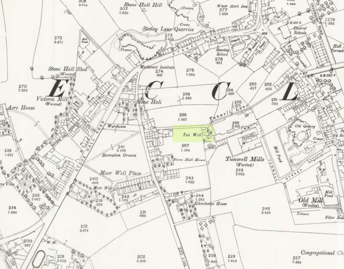
Sacred Well (destroyed):  OS Grid Reference – SE 17567 35473

Also Known as:

  1. Pendragon Well

Archaeology & History

Site on the 1893 map

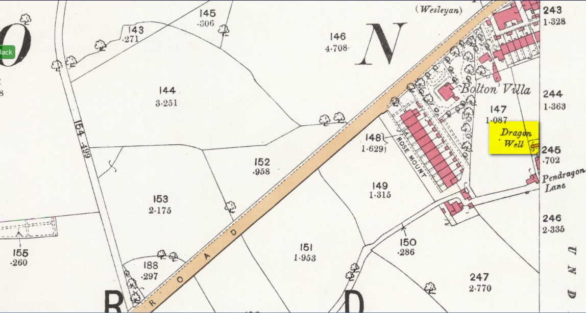
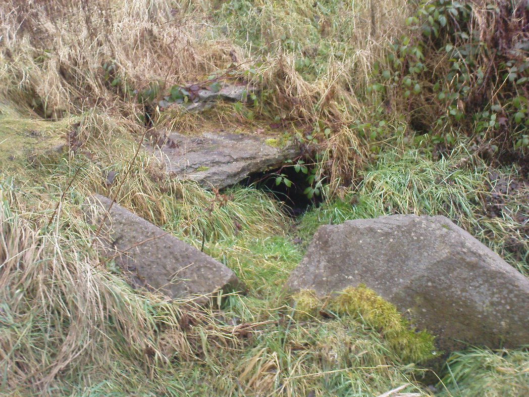
A most curious place:  this ‘Well of the Dragon’ as it was first called (on the 1852 OS-map) and subsequently the ‘Pendragon Well’ (on the 1922 map) just off Pendragon Lane, seems to have been forgotten in both folklore and history.  I grew up round here and no legends of dragons were known, either in my life, nor that of the old folks I knew; nor any pub of that name that might account for it.

Equally unexplained is the name of the adjacent ‘Pendragon Lane’, which has been known as that for some 175 years.  We have no Arthurian myths anywhere in West Yorkshire that remains in folk memory—and certainly nothing hereby that accounts for it.

As for possible landscape associations (i.e., serpentine geological features), nothing in the vicinity has any bearing on the name.  Indeed, the only thing of any potential relevance was the former existence of a healing rock known as the Wart Stone, some 100 yards to the east at Bolton Junction.  Such stones are usually possessed of naturally-worn ‘bowls’ of some sort on top of the rock—akin to large cup-markings—into which water collected that was used to rid the sufferer of warts or similar skin afflictions.  But such an association seems very unlikely.

The only thing we can say of this Dragon Well is that probably, in times gone by, a folktale or legend existed of a dragon in the neighbourhood that had some association with the waters here.  Dragons are invariably related to early animistic creation myths, and this site may have been all that remained of such a forgotten tale.  The nearest other place in West Yorkshire with dragon associations is six miles northwest of here on the south-side of Ilkley Moor.  In Britain there are a number of other Dragon Wells, the closest of which is in South Yorkshire.

© Paul BennettThe Northern Antiquarian

Tun Well, Eccleshill, Bradford, West Yorkshire

Healing Well:  OS Grid Reference – SE 1822 3593

Also Known as:

  1. Tunny Well

Archaeology & History

Tun Well, on 1893 map

First mentioned in local history accounts from 1618—as the Tunwells—it was highlighted on the first OS-map of Eccleshill in 1851.  Located on the aptly-named Tunwell Lane, it was a deep well covered by a large flat slab of stone, at the back-end the old Victorian mill.  The stone was put there to prevent children falling into it.  Some old locals thought the name of the place derived from a ‘tun’, or hundred, meaning it to be a hundred feet deep; although as A.H. Smith (1961) tells, tun could equally relate it to be one of Eccleshill’s town wells, of which there were several.  It used to be one of the principal drinking supplies for the village and was said to rarely run dry.  In William Ranger’s (1854) survey, he told this to be one of the sites to which local people relied in times of drought, where the land-owner allowed local folk to collect their supplies.

Folklore

The old cobbled Tunwell Lane was long ago supposed to be the haunt of a phantom black dog: a visionary precursor of death and Underworld guardian. Its spirit came and went into the deep well.  I remember hearing tales of this when I was a young lad, as the old women who worked in the adjacent mills spoke of it.  The ghost of a so-called ‘white lady’ was also said to walk along Tunwell Lane.

In more recent times, Val Shepherd (2002) included this in her short survey of wells in the area as being on “an alignment” with Eccleshill’s Moor Well and Holy Well.  She thought “it may be part of a ley line”, but her alignment is inaccurate and doesn’t hit the spots.

References:

  1. Crapp, H.C. & Whitehead, Thomas, History of the Congregational Church at Eccleshill, Watmoughs: Idle 1938.
  2. Ranger, William, Report to the General Board of Health on a Preliminary Inquiry into the Sewerage, Drainage, and Supply of Water, and the Sanitary Condition of the Inhabitants of the Township of Eccleshill, George Eyre: London 1854.
  3. Shepherd, Val, Holy Wells of West Yorkshire and the Dales, Lepus: Bradford 2002.
  4. Smith, A.H., The Place-Names of the West Riding of Yorkshire – volume 3, Cambridge University Press 1961.

© Paul BennettThe Northern Antiquarian


Sweet Willy Well, Wrose, Shipley, West Yorkshire

Healing Well: OS Grid Reference – SE 16561 36440

Also Known as:

  1. Lin Well
  2. Silver Stream
  3. Sugar Stream

Getting Here

Sweet Willy Well, Eccleshill

Whether you’re coming here from Wrose or Eccleshill, go along Wrose Road and turn down Livingstone Road at the traffic lights. Down here, when the road splits, head to your right until you meet with those stupid road-block marks (where you can only get one car through). Just here, walk down the slope and path on your right, and before you hit the bottom of the slope, walk down the small valley for about 20 yards until you see the small stream appear from beneath some overgrown man-made stone lintels. That’s it!

Archaeology & History

When I was a kid I used to play down this tiny valley when the waters here still had small fish swimming away (we used to call them ‘tiddlers’). The fish seem to have gone, but there are still waterboatmen on the surface, indicating that we still have fresh water here – and on my most recent visit, I cautiously tasted the waters and found them OK (the prevalence of broken bottles and beer cans from locals doesn’t inspire you to drink here though).

Initially located on the local boundary line between Eccleshill and Wrose, the waters used to be found running into a trough about 100 yards further up the small valley, but this has been lost and housing now covers its original site.  You can see how the stream has cut the valley further upstream, but now it bubbles up from beneath the rocks shown in the photo.  Bradford historian Robert Allen (1927) described the site in his survey as originally being between North Spring and South Spring Wood.

Although the name Sweet Willy Well remains a mystery, one of its other titles — the Lin Well — relates to the presence of linnets that used to be found in great numbers here.  The ‘Sugar Stream’ name is one we knew it as locally as children, due to the once sweet taste of the waters.  It is likely to have had medicinal properties, but these have been forgotten.  No archaeological survey has ever been done of this site.

References:

  1. Allen, Robert C. (ed.), The History Of Bolton In Bradford-Dale; with Notes on Bradford, Eccleshill, Idle, Undercliffe, Feather Bros: Bradford 1927.

© Paul Bennett, The Northern Antiquarian


Holy Well, Eccleshill, Bradford, West Yorkshire

Holy Well:  OS Grid Reference – SE 1878 3622

Getting Here

Take the A658 road north out of Bradford, past Undercliffe, and downhill towards Greengates.  When you meet with the large junction where Ravenscliffe Avenue turns to your right – stop!  Immediately on the left-hand side of the road is where the old well used to appear.

Archaeology & History

Old map showing Eccleshill's Holy Well
Old map showing Eccleshill’s Holy Well

In times past this was one of the most renowned holy wells in the region (we have at least 200 in West Yorkshire). First recorded as a holy well in 1585, specialist writer Edna Whelan remembers the waters here running into a stone trough at the side of Harrogate Road when she was young.

In 1932, local historian W.E. Preston described, “the remains of what was once a fine grove of trees leading up the hillside from the road to its source,” implying ritual commemoration and a procession to the site.  Today, this grove is still evidenced by the straight footpath across the main road, leading to the infamous Ravenscliffe estate.

In 1704 a court case was brought against some locals – Mr & Mrs Richard and Sarah White (and their daughter, Mary) – “for diverting the water from its ancient channel.”

In 1867 it was described in the Object Name Book:

“A considerable and well-known spring, it has the appearance of having been a bathing place. A bank has been thrown up on the east side, and a broken wall remains on the other sides. There is no tradition about it. It is likely to have been of some note…in the days of Romanism. Large trees are ranged on either side of the approach to it, forming a grove.”

Up till 1978, Andrea Smith (n.d.) reported the well to still be “protected by local tradition,” but this is no longer possible. Yorkshire Water don’t particularly give a damn about its preservation (water is money folks!) and today it’s covered by a man-hole in the garden.

References:

  1. Preston, William E., ‘Notes on the Early History of the Manor of Eccleshill,’ in Bradford Antiquary, 5, 1912.
  2. Preston, William E., ‘Some Local Holy Wells,’ in Bradford Antiquary, June 1932.
  3. Smith, Andrea, ‘Holy Wells Around Leeds, Bradford & Pontefract,’ in Wakefield Historical Journal 9, 1982.
  4. Whelan, Edna & Taylor, Ian, Yorkshire Holy Wells and Sacred Springs, Northern Lights: Pocklington 1989.

© Paul Bennett, The Northern Antiquarian