Cursus: OS Grid Reference – TL 8406 6732 to TL 8291 6876
Also known as:
- All Saints Cursus

Archaeology & History
The remains of this cursus can be found in the valley of the Lark. In Paul Devereux’s (1989) survey of these gigantic neolithic features he described how today we can only see it as crop-markings, stretching in a
“roughly northwest to southeast direction for about a mile; its width approximately 140 feet (42.5 metres). It is comprised of three straight lengths, each at slightly different orientations – there is no way of telling at present (c.1988) whether or not these segments were built at different times, as is believed to be the case at certain other cursuses where changes of direction occur. The northmost terminus has not been located, but the southern one is visible from the air and is next to a circular crop-mark.”
Some 350 yards further on from the end of the cursus is the village church of All Saints, whose old festival date centred around Halloween, or the old pre-christian New Year.
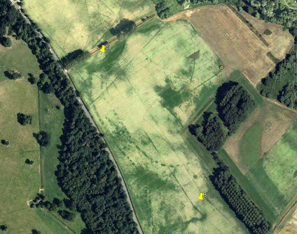
Starting at the southern end of the cursus (A), it headed northwest for more than 650 yards (0.6km) before it took its first slight change of direction. Almost all of this first section has been built over by the village; but we can see it in aerial views again on the north side of the village at the edge of the field, at TL 8365 6774 (B). Changing direction slightly, it moves more NNW for another 590 yards (539m) and then kinks again slightly more NNW at TL 8325 6809 (C), before heading onto its final change in direction 464 yards (424m) away at TL 8299 6843 (D). From this point, more recent surveys have shown it to continue further onwards, with another minor alteration in its direction to the north. It goes in a dead straight line for another 336 yards (334.5m), seemingly terminating a short distance before the old Mill Farm at Hengrave, at TL 8291 6876. Just as at the start of the cursus at point ‘A’, where the terminus is curved in a slight arc, so the northern terminus was also curved. The total length of this monument is 1.2 miles (1.9km).
As can be seen in the aerial view (above), a faded double-line of earthworks exists immediately west (left) of the cursus, intersecting and going across the monument. This is the Fornham All Saints causewayed enclosure: another early neolithic monument which may or may not be earlier than the cursus itself.
A curious architectural coincidence (?) can be seen roughly 500 yards west of the central section of the cursus. Running roughly parallel with the prehistoric earthwork is another dead straight avenue leading out, southeast, from Hengrave Hall and, near its terminus, kinks slightly left, just as the cursus monument does about 550 yards away. Fascinating…
References:
- Loveday, Roy, Inscribed Across the Landscape, Tempus: Stroud 2006.
- Oswald, A., Dyer, C. & Barber, M., The Creation of Monuments, English Heritage: Swindon 2001.
- Pennick, N. & Devereux, P., Lines on the Landscape, Robert Hale: London 1989.
© Paul Bennett, The Northern Antiquarian