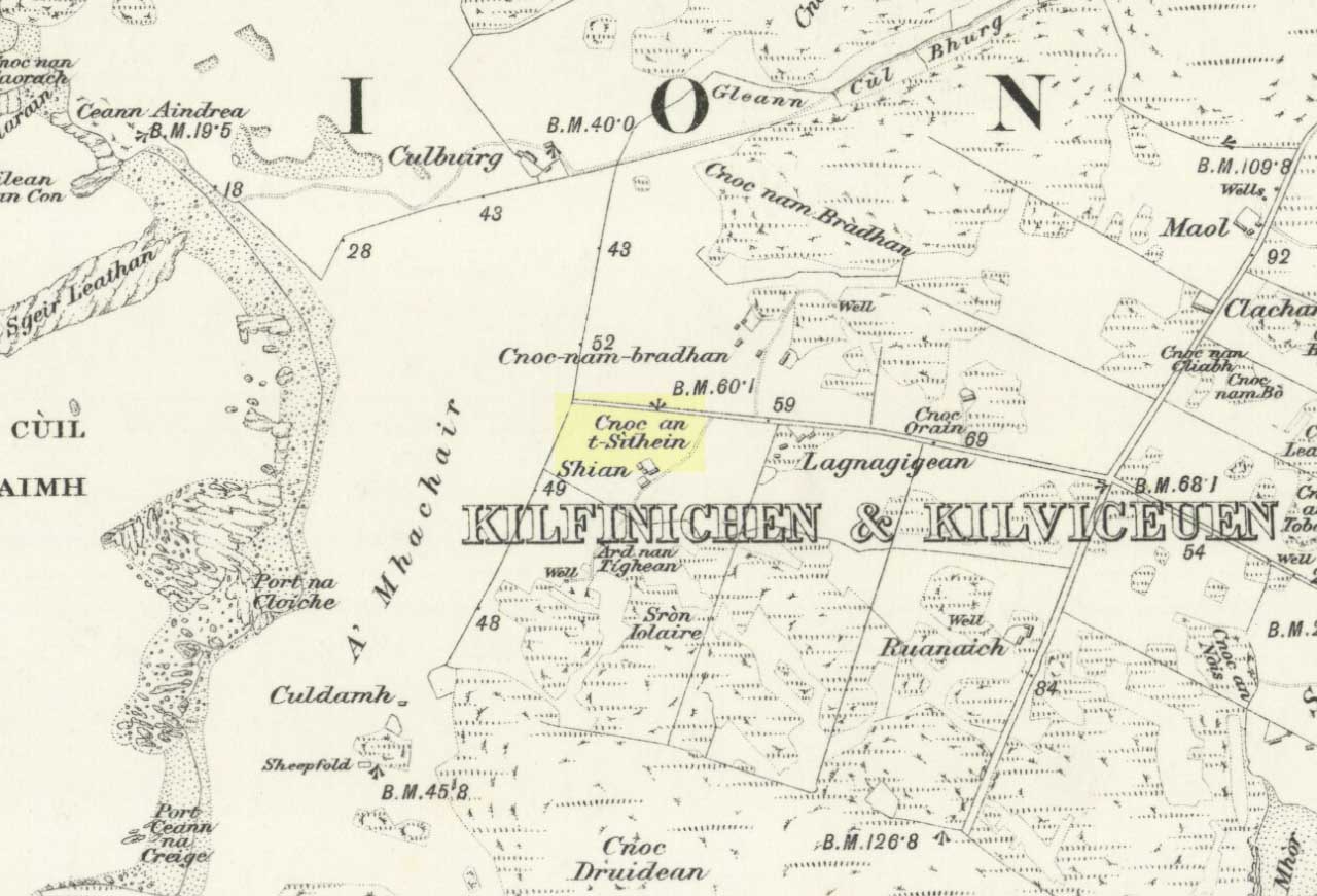
Sithean Mor, Shian, Iona

Cairn Circle (destroyed):  OS Grid Reference – NM 2721 2371

Also Known as:

  1. Angel Hill
  2. Cnoc nar-aimgeal
  3. Sithean More

Archaeology & History

There have long been rumours of stone circles on the druid’s isle of Iona, but many are dismissed as little more than errors on behalf of antiquarians, or false descriptions of hut circles and settlement remains.  The stone circle of Sithean Mor however, does seem to have existed until only a century or two ago.  It was first mentioned by the great traveller, Thomas Pennant (1776), who visited Iona more than once.  He told us:

“On my return I saw, on the right hand, on a small hill, a small circle of stones, and a little cairn in the middle, evidently druidical, but called the hill of the angels, Cnoc nar-aimgeal; from a tradition that the holy man had there a conference with those celestial beings soon after his arrival.  Bishop Pocock informed me that the natives were accustomed to bring their horses to this circle at the feast of St. Michael, and to course round it.  I conjecture that this usage originated from the custom of blessing the horses in the days of superstition, when the priest and the holy-water pot were called in: but in latter times the horses are still assembled, but the reason forgotten.”

Site of the Sithean Mor on the 1881 OS-map

The day of the “feast of St. Michael” that Pennant mentioned was our indigenous heathen New Year, or Halloween, now usurped and misrepresented by countless plastic pagans and christians alike. It would appear from Pennant’s description that the circle in question was more likely a cairn circle.  The fact that the heathen islanders celebrated annual rites here at Samhain, strongly implies there was once a hero-myth and a creation myth in evidence, but I am unaware of any remaining tales that may help confirm this.  The coming of St. Columba may be responsible for this lack of oral tradition.

More than a century after Pennant’s visit here, the ring of stones had been destroyed.  We know this from the description given by Archie MacMillan (1898) in his fine text on the antiquities of Iona, where he said,

“Angel Hill, called in the vernacular Sithean More. There was, not so very long ago, a circle of standing stones on the top of this hillock. They have been used for other purposes.”

Folklore

The most commonly recited tale of this grassy rise is that when St. Columba brought christianity to the island, he communed here with the angels.  This is a simple displacement tale: of a new faith replacing an older one. The old name of the hill, Sithean Mor, tells that the littlepeople or fairy folk once held influence here.

References:

  1. Cumming, C.F.G., In the Hebrides, Chatto & Windus: London 1883.
  2. MacMillan, Archibald, Iona: Its History and Antiquities, Houlston & Sons: London 1898.
  3. Pennant, Thomas, A Tour in Scotland, 1772 – Part 1, Benjamin White: London 1776.

© Paul Bennett, The Northern Antiquarian


Dun Dubh, Ford, Argyll

Dun:  OS Grid Reference – NM 8640 0479

Also Known as:

  1. Canmore ID 22821

Getting Here

From Ford village, take the track that goes uphill (west) running near the edge of the forest-line. Keep going until you hit the top of the forest and the large rocky hill above you (on your right) is where you need to be heading.  The rise to your left is Dun Chonallaich.  Walk around the bottom of the hill until you get to the other side (you should be 100 yards or more above the tree-line) where you’ll notice a ‘pass’ running west, with a rocky knoll above you on your right.  That’s it!

Archaeology & History

Thought to date from the Iron Age, the remains here cover an area 15 yards by about 25 yards.  Remains of walling around the edge of the summit nearly a yard wide in places define quite clearly where the ‘fort’ was centred.  The entrance to the site was found on the northwestern side.  In more recent times however, animal pens have intruded on the remains here and the archaeological remnants are much denuded.

Folklore

Samhain fires were lit on the larger ridge above this ruined fort until recent years, as some old local folk will tell you. These Halloween fires (done to celebrate the old New Year) were stopped a short time after the new ‘owner’ of the Auchinellan Estate (on whose land Dun Dubh is found) took exception to them and, for all intent and purpose, deemed them a fire hazard! The lady in question who inherited the Estate was in fact a devout christian who took exception to the local “pagan” goings-on, contrary to the beliefs of the previous Estate owner, who not only allowed such old events, but played a part in them.  Local folk hereabouts, not surprisingly, aint too keen on their part-time dictatorial christian neighbour.

The fires up here were also related to the linear cemetery at Kilmartin. Here the giant tombs all line up & point to Dun Chonallaich, behind which hides the more flattened top of Dun Dubh. When the Halloween fires were lit on top of this, the glow from behind the great pyramid of Chonallaich all the way down to Valley of the Kings, was spectacular! One wonders just how long the local people had been doing this…

References:

  1. Royal Commission on the Ancient & Historical Monuments, Scotland, Argyll – volume 6, HMSO: Edinburgh 1988.

© Paul Bennett, The Northern Antiquarian


Fornham All Saints, Bury St. Edmunds, Suffolk

Cursus:  OS Grid Reference – TL 8406 6732 to TL 8291 6876

Also known as:

  1. All Saints Cursus
The Forham All Saints Cursus (image courtesy, Paul Devereux)

Archaeology & History

The remains of this cursus can be found in the valley of the Lark.  In Paul Devereux’s (1989) survey of these gigantic neolithic features he described how today we can only see it as crop-markings, stretching in a

“roughly northwest to southeast direction for about a mile; its width approximately 140 feet (42.5 metres). It is comprised of three straight lengths, each at slightly different orientations – there is no way of telling at present (c.1988) whether or not these segments were built at different times, as is believed to be the case at certain other cursuses where changes of direction occur. The northmost terminus has not been located, but the southern one is visible from the air and is next to a circular crop-mark.”

Some 350 yards further on from the end of the cursus is the village church of All Saints, whose old festival date centred around Halloween, or the old pre-christian New Year.

Central section of cursus

Starting at the southern end of the cursus (A), it headed northwest for more than 650 yards (0.6km) before it took its first slight change of direction.  Almost all of this first section has been built over by the village; but we can see it in aerial views again on the north side of the village at the edge of the field, at TL 8365 6774 (B).  Changing direction slightly, it moves more NNW for another 590 yards (539m) and then kinks again slightly more NNW at TL 8325 6809 (C), before heading onto its final change in direction 464 yards (424m) away at TL 8299 6843 (D).  From this point, more recent surveys have shown it to continue further onwards, with another minor alteration in its direction to the north.  It goes in a dead straight line for another 336 yards (334.5m), seemingly terminating a short distance before the old Mill Farm at Hengrave, at TL 8291 6876.  Just as at the start of the cursus at point ‘A’, where the terminus is curved in a slight arc, so the northern terminus was also curved.  The total length of this monument is 1.2 miles (1.9km).

As can be seen in the aerial view (above), a faded double-line of earthworks exists immediately west (left) of the cursus, intersecting and going across the monument.  This is the Fornham All Saints causewayed enclosure: another early neolithic monument which may or may not be earlier than the cursus itself.

A curious architectural coincidence (?) can be seen roughly 500 yards west of the central section of the cursus. Running roughly parallel with the prehistoric earthwork is another dead straight avenue leading out, southeast, from Hengrave Hall and, near its terminus, kinks slightly left, just as the cursus monument does about 550 yards away. Fascinating…

References:

  1. Loveday, Roy, Inscribed Across the Landscape, Tempus: Stroud 2006.
  2. Oswald, A., Dyer, C. & Barber, M., The Creation of Monuments, English Heritage: Swindon 2001.
  3. Pennick, N. & Devereux, P., Lines on the Landscape, Robert Hale: London 1989.

© Paul BennettThe Northern Antiquarian