Stone Circle (destroyed): OS Grid Reference – NO 332 430 (approximation)
Archaeology & History
This stone circle wasn’t logged in either Barnatt (19890 or Burl’s (2000) standard megalith inventories. The only mention of it seems to be in Alex Elliott’s (1911) rare work on the region, in which he described it as being located “within the grounds of Mylnefield”. All trace of it would seem to have gone. Elliott told it to have been,
“elliptical in form and consisted of six large boulders – three at the east, three at the west, with a gap between capable of holding an equal number of stones.”
References:
Elliott Alexander, Lochee – As it Was and As it Is, J.P. Mathew: Dundee 1911.
Cup-and-Ring Stone (removed): OS Grid Reference – NO 378 308
Archaeology & History
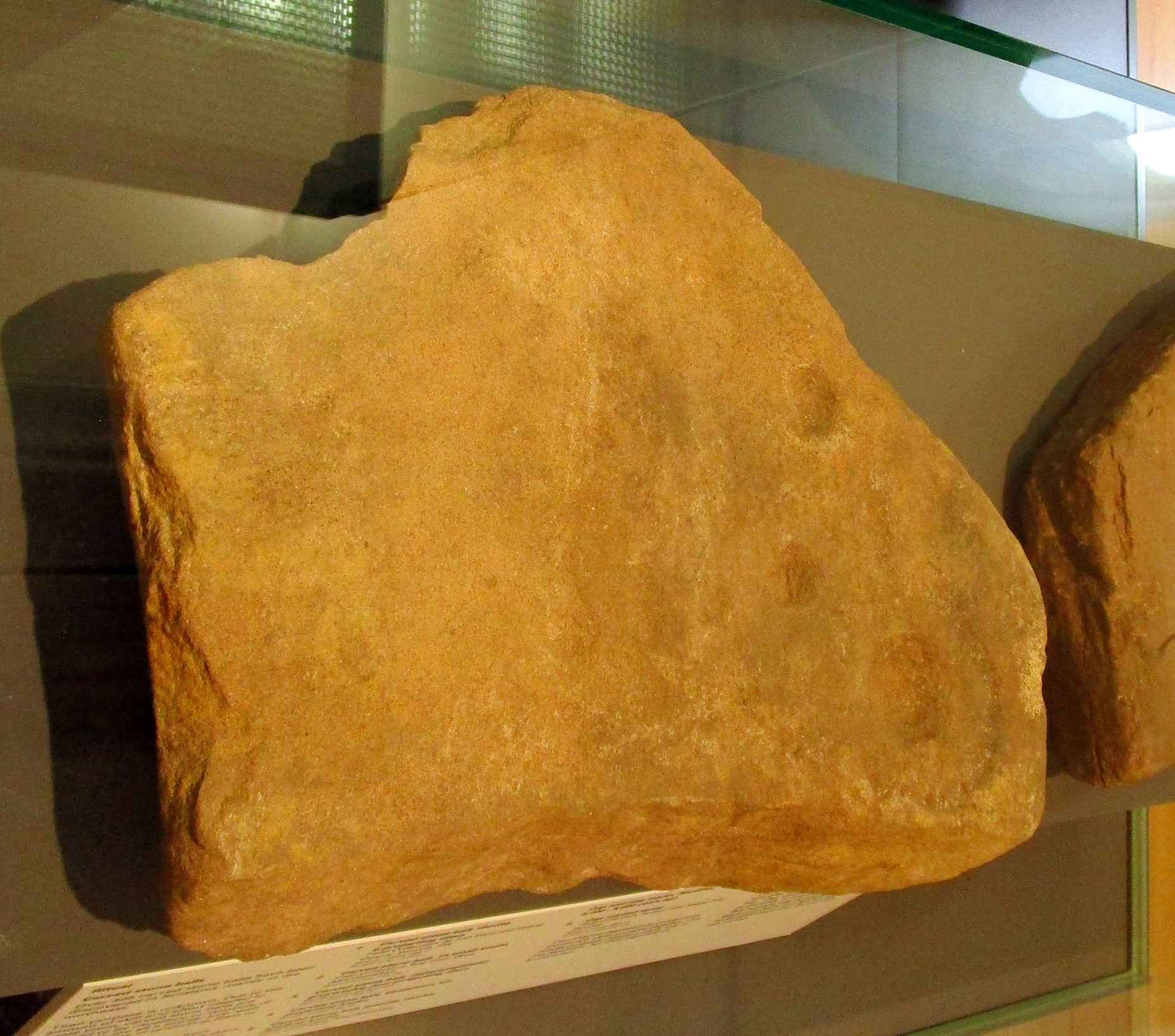
Cup & ring stone of Balgay Hill
This little-known cup-and ring stone was found at ground level sometime around 2003, near the top of Balgay Hill. A small portable stone that may have been broken from a larger slab, it has what seems to be two if not three cup-and-rings, accompanied by two or three single cup-marks. One of the rings seems to have a faint line coming out of it. Unfortunately none of this is clear in the photos I took (the one attached here is the best), as it lives under glass in Dundee Museum, so it was very difficult to get decent images. It is now housed in the McManus Museum in Dundee (a damn good place, with very helpful staff) and well worth checking out if you’re in the area.
Cup-Marked Stone (lost): OS Grid Reference – NO 3975 3340
Also Known as:
Magdalen’s Kirkton Stone
Archaeology & History
In the mid-1890s, workmen ploughing one of the fields near the steading at Magdalen’s Kirkton farm hit a large stone beneath the soil. It turned out to be the covering stone of a prehistoric burial, or cist, that was aligned east-west. Whilst the remains in the cist had all but turned to dust, the covering stone had a number of cupmarks on it. It was described only briefly by R.N. Kerr (1896), who told that,
“The stone forming the lid of the cist is cup-marked. It weighs 5 cwt., 1 qr., 21½ lbs., and its thickness varies from 9 to 12 inches. There are 40 or more cup-markings on it, varying from 1 to 3 inches in diameter.”
It would seem that no sketches were made of this carving and I’ve been unable to find any more details about it. Help!
Healing Well (destroyed): OS Grid Reference – NO 4032 3025
Archaeology & History
This old water supply had no direct ‘holy’ nature, despite its proximity to the cathedral, the old market cross and St Clement’s Well some fifty yards away! Most odd. A much more mundane story lies behind this long lost water source. The Dundee historian William Kidd (1901) told us,
“When the public wells were erected, about the year 1749, to supply the town with water from the Lady-well reservoir at foot of Hilltown, one was placed on the High Street, on the east side of the Cross, and was called the Cross Well.”
It didn’t have too long a life either—much like the old Market Cross, for,
“In the year 1777 that quaint structure was demolished. The platform and octagonal tower were carted away as rubbish, the least decayed stones being selected to be used in other buildings. The stone shaft, also, was preserved, and placed beside the Old Steeple. With the demolition of the Cross, the Cross Well was cleared away from the High Street, but, as water was an essential to the people, the well was re-erected behind the Town House in St. Clement’s Lane. In that situation it remained for nearly one hundred years, when, being rendered unnecessary by the introduction of the Lintrathen water supply, it was also demolished, along with the old buildings in the Vault and St. Clement’s Lane, to make room for the additions to the Town House.”
References:
Colville, A., Dundee Delineated, A. Colville: Dundee 1822.
Holy Well (destroyed): OS Grid Reference – NO 4007 3046
Also Known as:
Grey Friar’s Well
Archaeology & History
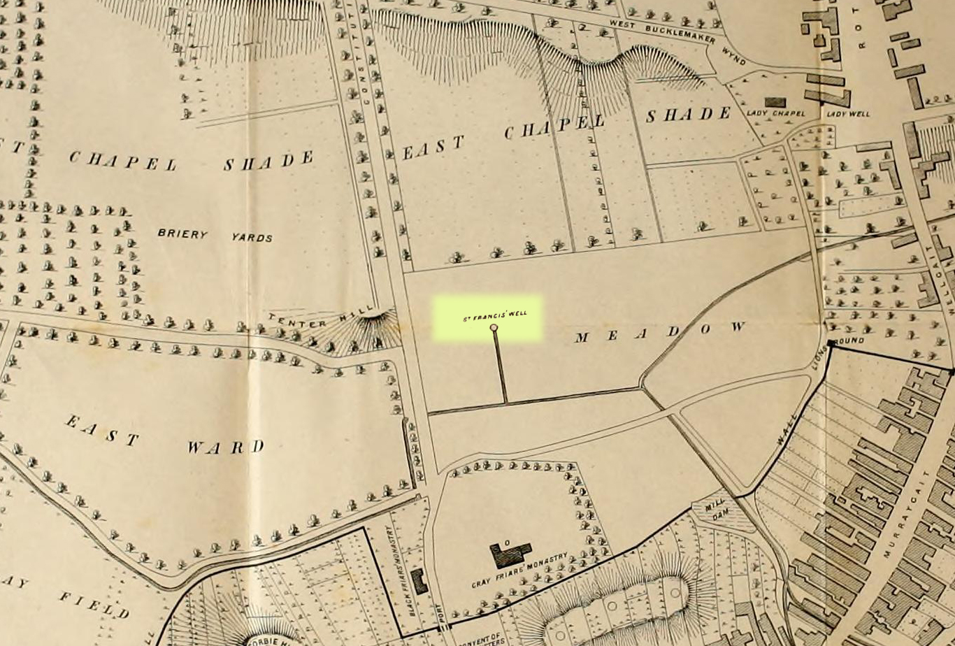
Site shown on 1776 map
This is another one of Dundee’s lost holy wells (see also the Lady Well, the Nine Wells, St Clement’s Well, St Mary’s Well and Sinavey Well), around which the town was first built. Its cold fresh waters were located less than a hundred yards north of the old Houff graveyard in the middle of town, or where Alex Maxwell (1884) described as upon “the sunny slopes of the Gray Friars’ meadows.”
Maxwell told us that this sacred site was the most favoured of the the holy wells in the area, having been dedicated to St Francis of Assisi by the monks who built the medieval Grey Friars monastery, whose ruins lie beneath the Houff graveyard. After the destruction of the priory in the 16th century, the holy well and surrounding meadows came under the ownership of the local council. The well had become ruinous and so was repaired back to its old condition, but a few decades later had become very neglected again and was ordered to be closed. It was mentioned in several early land rental documents, including this from 1630 which told,
“That haugh or meadow lying on the south side of the Tentour Hill, and on the east side of the meadow called Monorgan’s croft, togidder with the lands lying about St. Francis’ well, were set for the yearly penny mail of fifty-ane pounds.”
The most extensive description of it came from Alex Maxwell’s own pen, and I reproduce it here in full. He began by speaking of the other holy wells of Our Lady and St. Clement’s in Dundee, but told us that,
“The most important of them was the Gray Friars’ well, which came out of the rising ground westward from where the High School is built, and had been dedicated to the honour of St. Francis, the founder of the order — a man of exalted character, whom Dean Milman calls “most blameless and gentle.” The water, which ran perennially and was of singular purity, had no doubt been highly venerated in the days of the old Church, and it continued to be much esteemed, and even to maintain somewhat of its traditional sanctity, long after the memory of the good man whose name it bore had become forgotten.
“When the Friars’ house was in ruins, and the gardens laid waste, St. Francis’ well did not escape unharmed. One austere iconoclast—James Patrie was his name—had probably been offended at its sculptural reminiscences of the old faith, and he cast it down. When arraigned to answer for this,
“he confest and grantit that he took down the common well callit the Friar well, quhilk servit the haill town with guid and wholesome water, and referrit him in the Bailies’ and Council’s will thereanent; and they being advisit with his offence, declarit that he sail pay for the reparation of the said well and common warks the soum of ten pounds; always, gif he big and repair the well as Weill as it wes of before with lime mortar, or Pasch next, this pain to be remitted; otherwise, the day past and the well nocht biggit, to pay the said soum but favour.”
James, however, proved contumacious; the day did pass, and the well still lay in ruins. But he got further time, for the Council not yet having possession of the monastic lands, had not chosen to act arbitrarily, and
“James Patrie was ordained to repair the Friar well conform to the last act, under the pain contenit thereintil, betwix the date hereof and Whitsunday;”
and he probably then proceeded to restore it into good condition, as we do not find any other ordinance on the matter. He had not, however, erected it very substantially; for, before thirty years had elapsed, the structure was again ruinous, and the Council resolved
“that St. Francis’ well be of new biggit and made close, so that na common access be had thereto.”
“The meadow land of the Gray Friars which lay around the well, formed a pleasant open space for the use of the old burgh, and it was always held in much regard. Early in last century, the water from the Lady well was impounded and conveyed in pipes for supplying other cisterns throughout the town ; but St. Francis’ spring, which was softer and purer, was left undisturbed to flow down the grassy slope in its natural course ; and when the place became appropriated for homely purposes, and upon
“Its verdant braes,
The lasses used to wash and spread their claes,”
“the gossiping naiads made the meadow very lively as they plashed in the brimming basins of the Friars’ old well, or filled their pitchers at the fresh fountain, or sprinkled the water in crystal showers over their snowy linen. About the time that the ground was sacrificed for the erection of buildings, a dyer in the neighbourhood sank a well which evidently reached the source of the spring and drained it off. Years afterwards, when the place had been overbuilt, he ceased to use his well, and the stream, returning to its old course, found access into the lower part of a church which now covers the site of the fountain, much to the dismay of the deacons. The water was then carried off elsewhere, and will be seen no more ; and the remembrance of those virtues which belonged to the once famous well will soon have passed away.”
In Christian lore, St Francis’ festival day was October 4.
Holy Well (destroyed): OS Grid Reference – NO 4026 3072
Also Known as:
Ladies Well
Our Lady’s Well
Archaeology & History
Lady Well on 1776 map
One of at least five sacred wells (see also St Francis’s Well, the Nine Wells, St Clement’s Well, St Mary’s Well and Sinavey Well) that could once be visited in Dundee: like its compatriots they have all fallen under the hammer of the Industrialists and flow no more. Our Lady’s Well could once be seen near the ancient Chapel of our Lady, “flowing from under the Chapelshade Braes,” said Maxwell (1884), its waters “bright and sparkling,” but today it has been drained and laid to rest beneath the road. Its memory however, has been preserved in the modern place-names of the Ladywell Roundabout and the nearby Ladywell Avenue.
The well was mentioned as far back as 1409 when, as Alex Lamb (1895) found, it was referred to in a contract between the Constable of Dundee and the burgesses. It flowed freely until the beginning of the 18th century when, as Maxwell told us, “the water from the Lady well was impounded and conveyed in pipes for supplying other cisterns throughout the town.” Nicoll (1923) thought there may have been a well-house built around it. Previously, the water from here was one of many springs and burns that fed the larger Castle Burn down to the sea.
The generally approved idea that Lady Wells derive from St Mary was questioned in this instance in Colville’s (1822) survey, who thought, not unreasonably, that
“As a convent stood near the same place, it is more probable that it took the name of the Ladies-well, from the fair sisterhood, who must have been the guardians of it and of all the places near them.”
He may be right. Colville also brought attention to a second water supply close by that seemed to be of equal importance in a pragmatic sense as the Lady Well herself. In danger of being destroyed, the author brought attention to it and insisted on securing its survival. He wrote:
“A little to the west, and adjoining to the Lady-well, is a large garden lying on a gentle declivity, called the Lady-well Yard,— in which there is a most abundant spring of excellent water, that was never known to fail in the driest summer, even when the Lady-well was so drained as not to afford supply to the inhabitants. Should this be employed for a steam-engine in the present prosperous state of manufactures, a pit for the water would require to be sunk, which might materially injure the Lady- well. It would certainly, therefore, be of advantage to the town, if the Magistrates could procure this property,— which would prevent the Lady- well being endangered; and the addition of this copious spring would at all seasons afford a plentiful supply of excellent water to the town.”
Holy Well (lost): OS Grid Reference – NO 401 301 (approximation)
Archaeology & History
Cited just once in the “Register of the Great Seal” (Registrum Magni Sigilli) in the year 1512 CE, this Fontis Beate Marie, or Well of St. Mary has long since disappeared. Its exact location in the city has been forgotten, but it seems likely to have been close to St. Mary’s Church. Further research is needed.
Holy Well (destroyed): OS Grid Reference – NO 4035 3024
Also Known as:
Bishop’s Well
Saint’s Well
Archaeology & History
One of at least five sacred wells (see also the Lady Well, the Nine Wells, St Francis’s Well, St Mary’s Well and Sinavey Well) that formerly existed in old Dundee, this one dedicated to St. Clement was associated with the ancient church, also of his name. It could be found a short distance south of the church—itself long gone—”rising out of a knoll overhanging the river bank,” wrote Alexander Maxwell (1884) and possessing considerable renown to local people. This great Dundee historian found several early references to it in old council registers: one of which, from 1589, described a conflict regarding the building of a school on land owned by Andro Renkyne. And it was on this piece of land where St. Clement’s Well emerged. The school was built and then Rankyne built a gable up to the edge of the school but, in doing so, cut off his own access to the holy well. This somewhat short-sighted action of Renkyne’s was subsequently remedied in 1607 by Dundee Council. Maxwell told us:
“The Council “grantit him licence to strike furth ane windok in the north side wall of his tenement in St. Clement’s kirkyard, near to the well in the schoolhouse closs, or within the bounds of the said well, to the effect he may draw water furth of the well to his awn service, with this provision that he hald the windok continually close, except at sic time as the water is drawn thereat, and that he close up the windok with stane wark quhenever he beis requirit.”
The waters—”reputed to have sovereign virtues”— were protected and covered by an old well-house. When Alex Lamb (1895) came to write about it he told that it was of a circular form with “unmistakable traces of splendid workmanship.” On its stone roof was what seemed to be a somewhat crude carving of a bishop and because of this it acquired the name “Bishop’s Well.” Another title given it by some locals was the Saint’s Well.
In the middle of the 19th century the remains of the well-house could still be seen, albeit in a state of neglect between the school building and Renkeyne’s house. But their end was nigh. Maxwell continued:
“When the buildings were demolished a few years ago, the saint’s old well — its water yet pelucid and fresh — was discovered at the angle where the school joined to Andro’s house. Above it was the window which he struck furth for drawing water; but it had long before been built up and the purpose of it forgotten, and its curiously recessed position and uncouth masonry only served as a puzzle for ingenious antiquaries.”
Subsequently he lamented the demise of the well telling how it had “been covered over by the extension of the Townhouse.”
Folklore
Alexander Maxwell (1891) told how the church was used as a shrine by local people and fishermen, as St. Clement of Rome had been cast into the sea chained to an anchor and so became the patron saint of sailors. He thought such properties, “would, no doubt, be in request for the supply of ships.”
St. Clement himself was a very early, first century saint, said to have died in 99 CE. His festival date is 23 November.
References:
Lamb, Alexander C., Dundee: Its Quaint and Historic Buildings, G. Petrie: Dundee 1895.
In Mason Inglis’ (1888) fascinating history of the village of Auchterhouse, he describes a number of prehistoric antiquarian remains—some destroyed, others still in place. But this old ring of stones is another of our ancient monuments that has fallen in the wake of the Industrialists with their ‘progress’ and ecocide. Mr Inglis told,
“South of the Templelands another group of these mysterious circular stone relics of pagan times at one time stood, and was also held in much regard, and recognized as an ancient place of worship. This group, however, unfortunately was demolished during excavations for railway purposes.”
He goes on to describe the finding of other prehistoric tombs and “unhewn slabs…in regular rows and at equal distances apart” in the same area. It seems that many of these have also been destroyed.
Standing Stone (destroyed): OS Grid Reference – NO 486 339?
Archaeology & History
The only reference I can find about this site is in A.J. Warden’s (1880) massive survey of the county of Angus—previously called ‘Forfarshire’—where, in his discussion of the hillforts of the area, he told us that,
“About a quarter of a mile distant from The Laws is the Gallow Hill of Ethiebeaton. In a field, a little to the south, there formerly stood a large upright stone called Tods Stone.”
All trace of it disappeared when quarrying operations were undertaken there, also destroying a number of prehistoric tombs close by. The monolith may have had some association with the tombs, but we cannot be certain.
The name of the stone,tods, probably derives from the word ‘foxes’, although we cannot be certain of this either, as there are a variety of other Scottish dialect words relating to ‘tod’that may have had bearing on the name.
If anyone has any further information about this long lost site, we would gladly welcome it.
References:
Grant, William (ed.), The Scottish National Dictionary – volume 9, SNDA: Edinburgh 1973.
Warden, Alex J., Angus or Forfarshire – volume 1, Charles Alexander: Dundee 1880.