Take the A7 road south from Edinburgh central (off Princes Street) for several miles. It becomes known as the Old Dalkeith Road eventually, just as it passes the huge wooded ground of Craigmillar Castle on your left (east) and the Inch estate on your right. Walk along here, keeping your eyes peeled for the small path that takes you onto Ravenswood Avenue. Barely 30-40 yards from the main A7 road, the standing stone is there surrounded by railings.
Archaeology & History
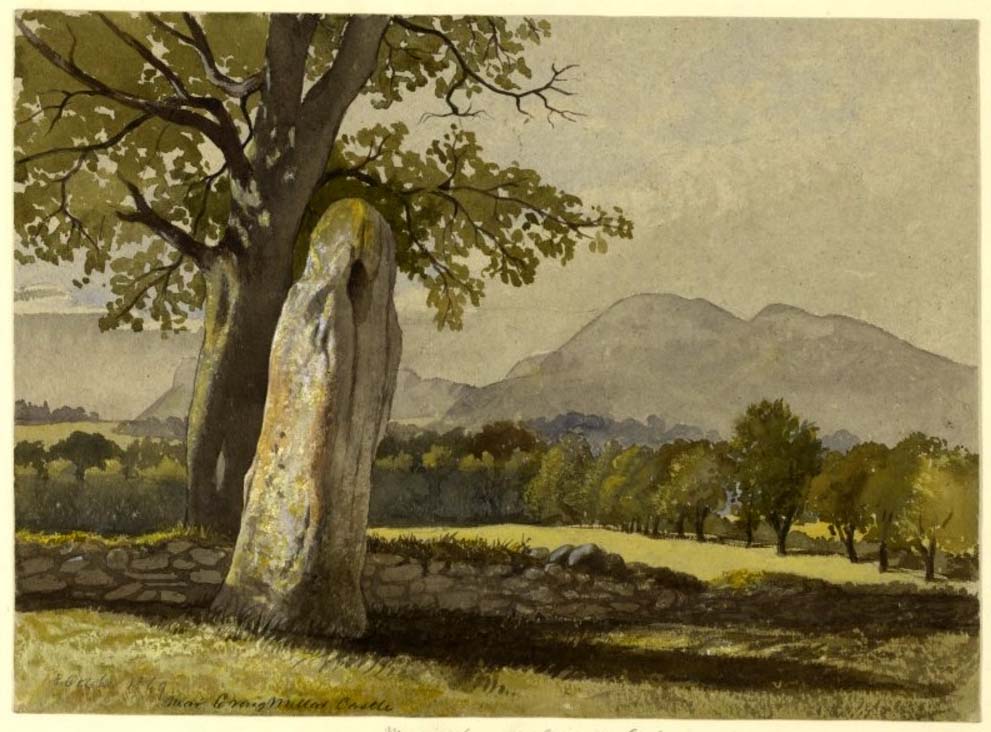
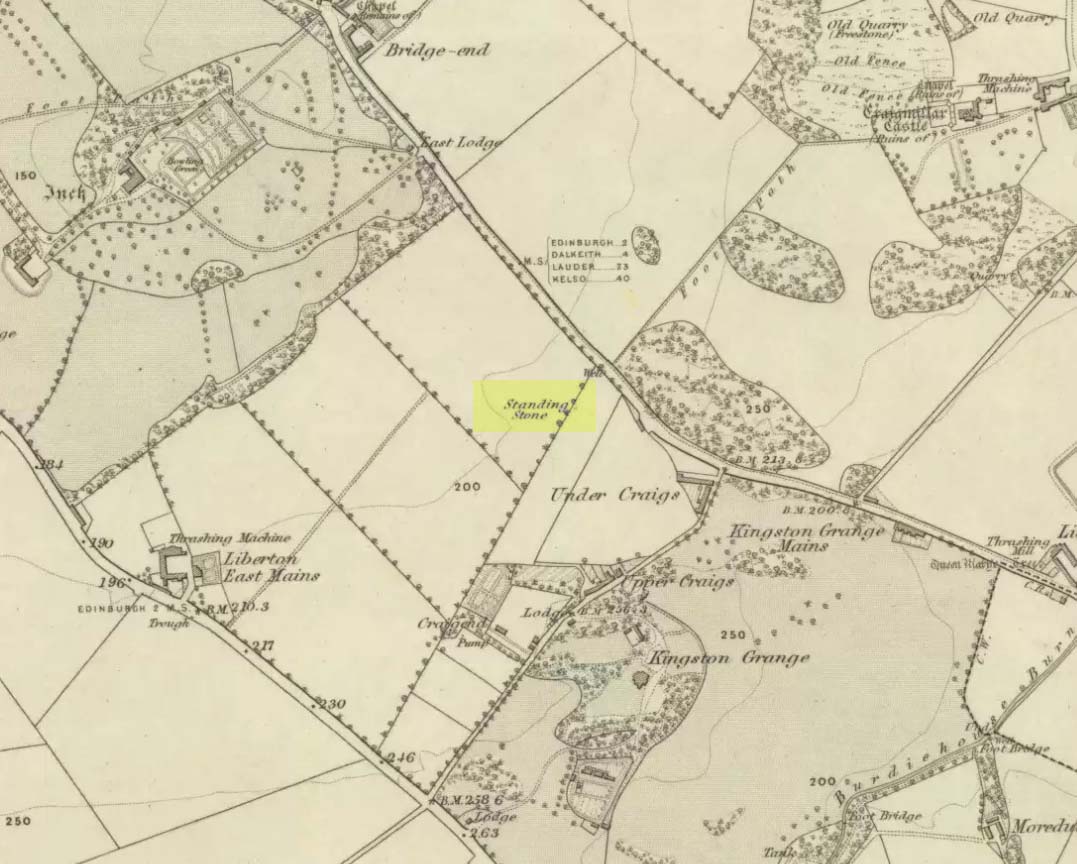
A curious place to find a standing stone – especially one that’s still alive! But that’s what we find on the Inch housing estate, thankfully. Highlighted on the 1855 Ordnance Survey map, it was one of a number of standing stones described in George Good’s (1893) fine survey on Liberton parish, which he thought commemorated ancient battles. When he wrote about it, the monolith was “built into the wall on the public road to Greenend”, just as shown on the OS-map. He told how the
“stone was taken down in the beginning of the present century (c.1801), when the road was widened, and it long lay in the field opposite, but was restored to its original place in 1891.”
When the Royal Commission (1929) lads came here many years later, they gave their own archaeocentric description, telling:
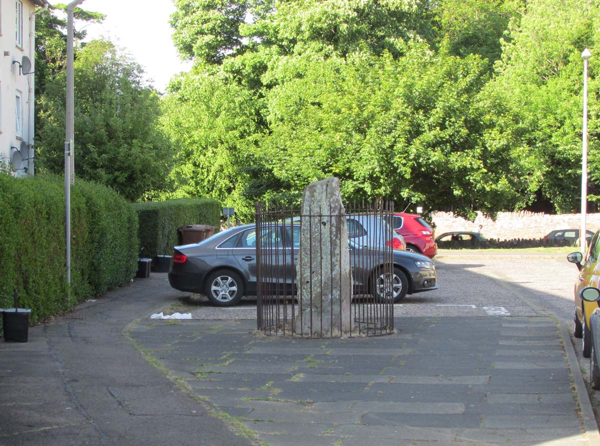
Site shown on 1855 mapThe old stone in its cage
“About 40 yards from the main road near Little France…is a standing stone, which is set up without packing, with its main axis almost due north and south, but with a slight inclination towards the east. It stands 6¾ feet above ground, and has a girth of 6 feet 5 inches at 3 feet from the base. It is of grey sandstone, badly weathered on two sides and without traces of any artificial markings or design.”
The monolith was included in Adam McLean’s (1977) megalithic survey of the area, where he rightly said how the iron fence that surrounds the stone destroys any atmosphere that might once be had here. Still, at least it’s still standing and is worth checking out if you’re in the area.
Folklore
The Ravenswood Stone
An old footpath that runs dead straight from Craigmillar Castle towards the stone was long ago said to be the pathway taken by the ghost of a white lady.
In days prior to the housing estate being built, local folk had annual bonfires here between Samhain (Halloween) and Guy Fawkes Night (Oct 31 – Nov 5).
References:
Good, George, Liberton in Ancient and Modern Times, Andrew Elliot: Edinburgh 1893.
McLean, Adam, The Standing Stones of the Lothians, Megalithic Research Publications: Edinburgh 1977.
Royal Commission on the Ancient & Historical Monuments of Scotland, Inventory of Monuments and Constructions in the Counties of Midlothianand West Lothian, HMSO: Edinburgh 1929.
In Thomas Whyte’s (1792) lengthy survey of Liberton village, as it was in the 1790s, we come across what seems to be the earliest description of this long-lost sacrede site on the northwest side of the parish. In writing of the beauty of the countryside hereby in those times, he told how,
“on the north by the rivulet called Braid’s-burn, near which there is a well which has the appellation…of the Lady’s or Virgin Mary’s well, famous for its large current, and the salubrity and lightness of its waters.”
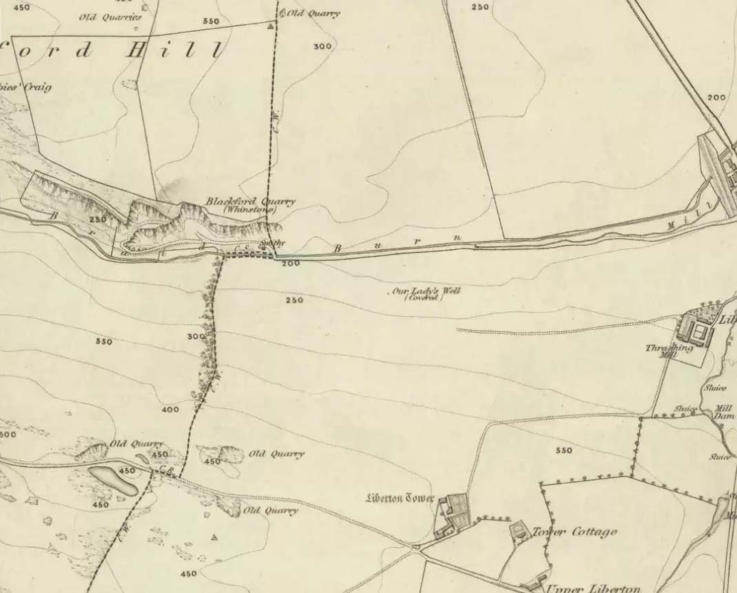
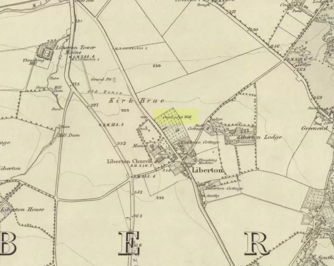
Site of Our Lady’s Well
Our Ladys Well on 1855 map
Mr Whyte believed that its dedication to Our Lady went way back, probably before Liberton parish was given to St. Cuthbert in the 11th or 12th century (whose own holy well could once be found several miles north, near Leith). Generally, wells that are dedicated to ‘Our Lady’, refer to the Virgin Mary; but prior to any christian affectation, the animistic genius loci of the waters would have been a local spirit.
It was visited and described by the Ordnance Survey lads in the Name Book of 1851, in which they said that Our Lady’s Well was,
“The site of a celebrated well situated in a hollow on the farm of Liberton Tower Mains, and dedicated to St. Mary, as it and the field is well known to be called to this day, “The lady’s Field” & Well”. This well however about 50 years ago underwent a drainage during some improvements that were making on the land. In its covered condition it takes a S.E. course till its Confluence with the Braid Burn where it is shown to this day as the water coming from the Lady’s Well, and from which a body of crystalized water flows copiously. It was supposed that a chapel was somewhere Convenient which gave rise to the name, but all traces have long since disappeared….”
“There is no tradition recorded among the County people as to whether this was a holy well, or resorted to for superstitious purposes. But it is well ascertained to have been once a remarkable well & an object well known and though now covered-in, the place is still well known, as is also the name.”
Although this holy well was shown on early and late 19th century OS-maps as ‘covered’, trying to find its exact position today has proven difficult. When Paul Hornby and I visited the site after some heavy rains in June, 2017, we found a large pool of water in the field exactly as shown on the old map. This was, however, misleading, as the owner of the land and the Blackford Glen Western Riding school—a Mr John Fyfe—told us that they had, for years, always wondered about its exact position, but been unable to ascertain it with any certainty. The pool in the field always appeared after the rains, he said. He did tell us however, that many years ago when he was digging in order that the Braid Burn stopped flooding his property, he came upon a length of ancient piping running in the direction of the burn, some 5 or 6 feet down, whose use he could not ascertain—but which might have once conducted the waters from the Lady Well away. No water was running through it though.
Near the middle of Liberton village a century or so ago, another holy well of the same name could once be seen less than a mile to the east.
Mentioned in passing by John Geddie (1926)—who was skeptical of any ‘holy’ associations here—this was one of two holy wells in Liberton parish with the same name. Whilst one is on the northwest side of the parish, this was closer to the centre of the village on the piece of land known as the Kirk Brae. It was some 200 yards northeast of the old church at the crossroads, originally dedicated to St. Cuthbert, whose feast day was March 20 — or right next to the Spring Equinox, perhaps when the waters here had greatest virtues.
Highlighted on the earliest OS-map of the region, little is known of it via the written records. Our primary account comes from the Name Book of 1852, where they told:
“An ancient well, known by more ancient settlers as the Christening Well, from the circumstance of this being the only one, from which water was taken in Ancient times for Baptizing; the water being considered the purest; hence it was dedicated to the Virgin.”